
Hillerman Map Project
Photographs of Oklahoma City

21412.B7.1, Z.P. Meyers/Barney Hillerman Photographic Collection, OHS (map #1B)
Montgomery Ward Building (OLI)
Address: 500 West Main Street
View: Southwest
Architectural Style: Art Deco (Blackburn, Henderson and Thurman 65)
Built: 1928 (Blackburn, Henderson and Thurman 65)
"The social and economic changes of the 1920s affected Oklahoma's business community in numerous ways, such as the locations of firms, construction of buildings, and the size of individual companies. The decade of change also spawned a generation of new businesses – chain department stores. One of the earliest and largest department stores to enter the Oklahoma County market was Montgomery Wards, which constructed its five-story multi-purpose building on West Main Street in 1928. This ornate art deco building was one of ten 'department' stores which the national catalog sales firm opened during the late 1920s. Montgomery Wards remained in the building until 1966, when social changes again forced a policy transition. This time it was the population shift toward the suburbs. Wards responded by constructing a new department store in a suburban mall and closing their downtown outlet." (Blackburn, Henderson and Thurman 65)

21412.B21.30, Z.P. Meyers/Barney Hillerman Photographic Collection, OHS (map #1C)
Katz Drug Store
Address: 200 West Main Street (Main and Robinson)
View: Southwest
Date: October 1944

21412.B54.40.8, Z.P. Meyers/Barney Hillerman Photographic Collection, OHS (map #1F)
Bird's-Eye View
View: Southeast
Date: October 1958
Buildings visible within this image include the Petroleum Building (left of the Liberty sign), the old Ramsey Tower (with the Liberty sign), the First National Bank Building (with the beacon) and the Biltmore Hotel (on right in the far distance.)

21412.B54.48.8, Z.P. Meyers/Barney Hillerman Photographic Collection, OHS (map #1G)
Aerial View
View: Northeast
Date: ca. early 1960s

21412.B54.54.31, Z.P. Meyers/Barney Hillerman Photographic Collection, OHS (map #1H)
Street View
View: East down 1st Street (Park Avenue) from Hudson Avenue (from Municipal Building)
Date: ca. late 1950s / early 1960

21412.B105.824, Z.P. Meyers/Barney Hillerman Photographic Collection, OHS (map #1I)
Telephone Building, Pioneer Building (OLI)
Address: 401–411 North Broadway Avenue
View: Northwest from 3rd Street and Broadway Avenue
Date: ca. 1928
Architectural Style: Telephone Building (right), Art Deco; Pioneer Building (left), Chicago (Oklahoma Landmarks Inventory)
Architect: Telephone Building, Layton, Hicks and Forsyth; Pioneer Building, William Wells (Oklahoma Landmarks Inventory)
Built: Telephone Building, 1927; Pioneer Building, 1907 (Oklahoma Landmarks Inventory)
"The expansion of Oklahoma City during the 1920s was reflected in the growth of the telephone company. As more people arrived in the booming city, more telephones were installed, new equipment was purchased, and new employees were hired. To house the expanded operations, Southwestern Bell constructed the sixteen story Telephone Building just north of the Pioneer Building. Designed by Solomon Layton, the buff-brick structure included set-backs, a tower, and ornate terra cotta." (Blackburn, Henderson and Thurman 72)
"The telephone came to Oklahoma City in 1893 with the arrival of the Missouri-Kansas Telephone Company. For about ten years this firm held a monopoly, but then came competition: Pioneer Telephone Company, a new and energetic organization which in a few short years had swallowed up a number of the small town exchanges, and now was challenging Missouri-Kansas for the city's telephone business. For a time it was necessary for citizens to subscribe to the services of both companies if they wanted to insure communication links with all other residents and businesses in town, but in 1905 this inconvenience was eliminated when Pioneer bought out Missouri-Kansas. Three years later the surviving company moved into this new headquarters building at Northwest Third and Broadway." (Edwards and Ottaway, Vanished Splendor 85)

21412.B132.3, Z.P. Meyers/Barney Hillerman Photographic Collection, OHS (map #1J)
YWCA Building
Address: 320 Northwest 1st Street (Park Avenue)
View: South
Built: 1931-1932 (Edwards and Ottaway, Vanished Splendor 53)
Destroyed: 1979 (Edwards and Ottaway, Vanished Splendor 53)
"In 1931-32 a new and enlarged YWCA Building was opened at First and Hudson, and this enabled the organization to offer living quarters for young women for the first time. There was a small auditorium, various activity and religious areas, and a cafeteria that was open to the public. This large building was demolished in 1979…" (Edwards and Ottaway, Vanished Splendor 53)

21412.BH441, Z.P. Meyers/Barney Hillerman Photographic Collection, OHS (map #1K)
Rock Island Railroad Depot
Address: North of Skirvin Hotel
View: Southeast
Date: 1930
Destroyed: 1930 (Griffin 128)

21412.BH519, Z.P. Meyers/Barney Hillerman Photographic Collection, OHS (map #1L)
First National Bank Building
Address: 120 North Robinson (and Northwest 1st Street)
View: Southeast
Architectural Style: Art Deco (Oklahoma Landmarks Inventory)
Architect: Weary and Alford (Oklahoma Landmarks Inventory)
Built: 1931 (Oklahoma Landmarks Inventory)
"The largest and costliest building constructed during the oil boom era was the First National Bank Building. Erected at a cost exceeding $5,000,000, the thirty-three story building housed the bank on the first several levels and offices on the upper floors. Size and cost were not the structure's only unique characteristics, however, for the combination of wood, metal and art deco ornamentation in the entryway and lobby made the building one of the most awe-inspiring structures in Oklahoma City." (Blackburn, Henderson and Thurman 74)

21412.M500.8, Z.P. Meyers/Barney Hillerman Photographic Collection, OHS (map #1Q)
Oklahoma Club Building
Address: 202–208 West Grand Avenue (Sheridan Avenue)
View: South
Architect: Hawk and Parr (Edwards and Ottaway, Vanished Splendor 72)
Built: 1921 (Edwards and Ottaway, Vanished Splendor 72)
"Built in 1921 and opened to its members in 1922, the Oklahoma Club Building was a delight to everyone. Designed by Oklahoma City architects Hawk and Parr, the structure was seven stories high with a light red brick veneer, white stone trim, and a red tile roof. The main floor had a spacious lounge, a cigar stand, and the manager's office. The club's main dining room was on the second floor and the members' wives and daughters enjoyed a ladies' parlor and five private dining rooms on the third floor. The fourth, fifth and sixth floors had apartments for members and their out-of-town guests. The top floor had one of the city's most beautiful ballrooms, available to members for dances or to outside organizations on rental basis. Located twenty-five feet west of Robinson, it was on the south side of the street at 202-208 West Grand. [Last] remembered as the Tivoli Inn, the entire building has disappeared." (Edwards and Ottaway, Vanished Splendor 72)
"Perhaps no where was the enthusiasm for Pei's plan more evident than at the Oklahoma Club, which got its start as an oasis for drinkers and gamblers during the heyday of national prohibition. The lower lobby of the club was described as a 'little Las Vegas,' filled with the sound of marbles rolling around roulette wheels, the mechanical chink of slot machines, and dice skipping across felt. The private club's membership included legislators and political power brokers, enough to encourage police to look the other way. With the end of prohibition and the growth of the suburbs and country clubs, the Oklahoma Club declined and finally closed in 1959." (Lackmeyer and Money 22)

21412.M202.9, Z.P. Meyers/Barney Hillerman Photographic Collection, OHS (map #1T)
Ramsey Tower (City National Bank Building)
Address: 204 North Robinson Avenue
View: Northeast
Architect: Clair F. Drury (Oklahoma Landmarks Inventory)
Built: 1931 (Oklahoma Landmarks Inventory)
"In 1928 the Oklahoma City oil boom fueled a new spirit in office building construction. One of the most ambitious plans was formulated by W.R. Ramsey, an oil man who had made a fortune during the boom. Designed by Clair Drury, the building was to be 33 stories tall with a series of set-backs. Total cost of the project exceeded $3,000,000." (Blackburn, Henderson and Thurman 74)
"To build his dream, Ramsey singled out New York's Starrett Brothers Corp., which had erected none other than the Empire State Building. In a heated race toward completion with First National Bank, construction was finished in a mere nine months." (Lott 16)

21412.BH2274, Z.P. Meyers/Barney Hillerman Photographic Collection, OHS (map #1V)
Street View
View: Northeast on Main Street
Date: March 1960

21412.BH2275, Z.P. Meyers/Barney Hillerman Photographic Collection, OHS (map #1W)
Street View
View: Southeast on the 200 block of West Main

21412.BH2382, Z.P. Meyers/Barney Hillerman Photographic Collection, OHS (map #1X)
Commerce Exchange Building
Address: 130 West Grand Avenue (Sheridan Avenue)
View: Southeast
Date: August 1955
Architect: Hawk and Parr (Griffith 13)
"The Southeast corner of Grand and Robinson has seen several changes since 1890, when Henry Overholser built his first opera house there. In 1903, after Overholser erected a new theatre one-half block or so to the west, the Tradesmen's Bank took over the corner, but in 1927 the old structure was razed to make room for the Commerce Exchange Building. This modern office building lasted a few years longer than the opera house, but it too is gone, and the corner is now a part of the four-block tract which forms the site of the Myriad Convention Center [Cox Convention Center]." (Edwards and Ottaway, Vanished Splendor 67)

21412.M3.1, Z.P. Meyers/Barney Hillerman Photographic Collection, OHS (map #1Y)
Wright Building
Address: 301 North Broadway Avenue
View: Northwest

21412.M9.4, Z.P. Meyers/Barney Hillerman Photographic Collection, OHS (map #1Z)
Colcord Building / Beverly's Chicken in the Rough Grill
Address: 15 North Robinson Avenue
View: Northeast
Date: September 1944
Architectural Style: Chicago (Lott 28)
Architect: William Wells (Oklahoma Landmarks Inventory)
Built: 1910 (Oklahoma Landmarks Inventory)
"The Colcord Building…stands as a reminder of the statehood building boom in Oklahoma City. Constructed in 1909 by early-day lawman, real estate developer, and oilman Charles Colcord, the structure for years has served as a model of excellence for architectural students. The Sullivanesque design, coupled with the intricate ornamentation, was the product of William A. Wells, one of Oklahoma City's most important architects." (Blackburn, Henderson and Thurman 26)
"Commissioned by Charles F. Colcord, the Colcord owes its strength to his noting that only those San Francisco structures of reinforced concrete survived that city's devastating earthquake and fire of 1906." (Lott 28)

21412.M12.3, Z.P. Meyers/Barney Hillerman Photographic Collection, OHS (map #2A)
Hales Building
Address: 201–203 West Main Street (Main Street and Robinson Avenue)
View: Northwest
Date: July 1941
Architect: Seldon Breck (Oklahoma Landmarks Inventory)
Built: 1910 (Oklahoma Landmarks Inventory)
Originally the State National Bank Building

21412.M30.22, Z.P. Meyers/Barney Hillerman Photographic Collection, OHS (map #2B)
Huckins Hotel; Huckins Garage
Address: 22 North Broadway Avenue
View: Southeast on Broadway Avenue from Main Street
Date: August 1952
Built: 1909 (The Oklahoman; Date 1971 Jul 12; Page 2)
Destroyed: 1971 (The Oklahoman; Date 1971 Jul 12; Page 1)
"The Annex was redesigned and opened in the early 1930s as a connecting garage to the Huckins Hotel, with the advertising slogan: 'Drive Right Into the Huckins Hotel.' Originally an extension with more hotel rooms, this seven-story garage held two hundred automobiles, and guests were able to drive in, register, and be taken at once to their rooms. By [this] time...the hotels were probably starting to feel the competition of the auto courts and early motels that permitted people easy access to their automobiles. At the Huckins you had the best of both worlds, and had the advantage of being near the center of downtown Oklahoma City as well." (Edwards and Ottaway, Vanished Splendor II 275)

21412.M32.41, Z.P. Meyers/Barney Hillerman Photographic Collection, OHS (map #2C)
The American National Building
Address: 140 West Main Street (Main Street and Robinson Avenue)
View: Southeast on Robinson Avenue from Main Street
Date: December 1954
Built: 1910 (Griffith 53)

21412.M41.1, Z.P. Meyers/Barney Hillerman Photographic Collection, OHS (map #2D)
Kirkpatrick Hotel
Address: 620 North Robinson Avenue
View: Southeast

21412.M45.13, Z.P. Meyers/Barney Hillerman Photographic Collection, OHS (map #2E)
Braniff Building
Address: 324 North Robinson Avenue
View: Southeast
Date: April 1941
Architect: Layton, Hicks and Forsyth (Blackburn, Henderson and Thurman 56)
Built: 1923 (Oklahoma Landmarks Inventory)
"One of Oklahoma City's most aggressive businessmen during the early 1920s was Thomas E. Braniff. In 1923, after making a fortune in the insurance business, he constructed the Braniff Building on North Robinson. Designed by the famous architectural firm of Layton, Hicks and Forsythe, the ten-story buff-brick building was a good example of neo-classical ornamentation typical of the period. Braniff's business career expanded even quicker after moving into his new building. The most famous of his accomplishments, and one which brought benefits to himself, Oklahoma City, and the nation, was the development of Braniff Airlines. Begun with only a five-place Stinson Detroiter, the first Braniff flight took off on June 20, 1928, bound for Tulsa. By the early 1940s the company had expanded to 270 employees, 10,000 route miles, and international connections, all directed from the Braniff Building." (Blackburn, Henderson and Thurman 56)

21412.M50.10, Z.P. Meyers/Barney Hillerman Photographic Collection, OHS (map #2F)
Street View
Address: 200 block Northwest 1st Street (Park Avenue)
View: Southwest
Date: 1946
21412.M50.12, Z.P. Meyers/Barney Hillerman Photographic Collection, OHS (map #2G)
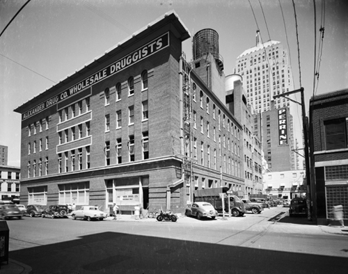
Alexander Drug Co.
Address: 218–232 Northwest 1st Street (Park Avenue)
View: Northeast from Harvey Avenue
Date: 1946

21412.M50.48, Z.P. Meyers/Barney Hillerman Photographic Collection, OHS (map #2H)
Street View
View: West on Northwest 1st Street (Park) from Broadway Avenue
Date: July 1956
The Skirvin Tower is on the right, across the street from the Skirvin Hotel. In the distance on the right is the Ramsey Tower; on the left is the First National Bank Building. The County Courthouse is seen at the end of the street.

21412.M50.32, Z.P. Meyers/Barney Hillerman Photographic Collection, OHS (map #2I)
Street View
View: Northwest on Northwest 1st Street (Park Avenue) towards Municipal Building
Date: October 1942

21412.M61.2, Z.P. Meyers/Barney Hillerman Photographic Collection, OHS (map #2L)
Perrine Building (Cravens Building)
Address: 113–125 North Robinson Avenue
View: Southwest
Date: before 1930
Architectural Style: Commercial Style
Architect: Hawk and Parr (Oklahoma Landmarks Inventory)
Built: 1927 (Oklahoma Landmarks Inventory)
"Built in 1927 by the family of James K. Perrine, the old Perrine Building [stood] on the site of the original Perrine Stables. Perrine came to Oklahoma City in 1891 and established his stables, an operation which was famous for its fine carriages and dependable horses. The U-shaped structure, which was built by Perrine's widow, was designed for the optimal ventilation and lighting, both important factors before the age of air conditioning and fluorescent lighting." (Blackburn, Henderson and Thurman 66)

21412.M66.1, Z.P. Meyers/Barney Hillerman Photographic Collection, OHS (map #2M)
The Herskowitz Building
Address: 25 West Grand Avenue (Sheridan Avenue)
View: Northeast on Grand Avenue
Destroyed: 1970 (Griffith 60)

21412.M71.1, Z.P. Meyers/Barney Hillerman Photographic Collection, OHS (map #2O)
Elks Lodge Building (Key Building, Oklahoma Natural Gas Building)
Address: 401 North Harvey Avenue
View: Northwest
Date: September 1944
Architectural Style: Italian Renaissance (Blackburn, Henderson and Thurman 59)
Architect: Sorey, Hill and Sorey (Blackburn, Henderson and Thurman 59)
Built: 1926 (Blackburn, Henderson and Thurman 59)
"The cultural and social climate of the 1920s encouraged participation in fraternal organizations. One of the most active and prosperous groups was The Benevolent and Protective Order of the Elks, which had organized their first lodge in Oklahoma City in 1898. Not until the 1920s, however, could the lodge afford to construct a large meeting hall. In 1925, with members pledging $500,000, the lodge hired the architectural firm of Sorey, Hill and Sorey to construct a twelve-story hall. Begun in March of 1926, construction progressed until five stories were erected: then the cash was exhausted. The resulting building's dominant style was Italian Renaissance, with cut limestone, double-arched windows, and wrought-iron balconies. The Elks remained in the building for five years before suffering the same fate as the Masons. The economic depression forced the lodge to sell the ornate structure to the Oklahoma Natural Gas Company. In 1947 the gas distribution firm purchased the structure." (Blackburn, Henderson and Thurman 59)

21412.M100.15, Z.P. Meyers/Barney Hillerman Photographic Collection, OHS (map #2P)
Street View
Address: L. to R.: Colcord, Liberty Theatre, Hales Building, First National Building, State Theatre, Baum Building
View: North on Robinson from Grand Avenue

21412.M101.5, Z.P. Meyers/Barney Hillerman Photographic Collection, OHS (map #2Q)
Farmer's National Bank Building
Address: 200 West Grand Avenue (Sheridan Avenue)
View: Southwest
Architect: Hawk and Parr (Griffith 13)

21412.M114.1, Z.P. Meyers/Barney Hillerman Photographic Collection, OHS (map #2R)
Security National Bank
Address: 109 North Broadway Avenue
View: Southwest
"The initial home of the Security National Bank appears to have been the 'busy corner' that formerly had been the location of the Roach & Veazey Drug Store. By 1915, the bank moved to the stately structure. The bank referred to these new quarters as 'the finest banking room in Oklahoma, at 109 N. Broadway.' A decade later, the Security National Bank moved in again, occupying the entire first floor of the new and impressive Medical Arts Building on the southwest corner of First (Park Ave.) and Broadway." (Edwards and Ottaway, Vanished Splendor II 207)
"The Liberty Plan Company of Oklahoma, founded in 1933 by company president Earnest H. Gill, occupied these quarters at 109 N. Broadway from 1944 until 1955. The imposing neo-classical structure had formerly been the home of the Security National Bank. The Liberty Plan Company was unusual in that it was investor-owned: common and preferred shares were offered for sale to the public. The advertising stressed that loans were made to employed people, 'women as well as men.' Loans ranging from $25 to $250 could be quickly obtained, with a repayment plan to fit the borrower's budget. The company moved to new quarters at 325 Northwest 2nd (Kerr) in 1955. The concern did well for several years, but, after the Gill family retired from active management in 1965, went into a rapid decline and soon ceased operations." (Edwards, Oliphant and Ottaway 443)

21412.M115.3, Z.P. Meyers/Barney Hillerman Photographic Collection, OHS (map #2S)
Criterion Theatre
Address: 116–120 West Main Street
View: Southwest
Date: ca. late 1929
"The Criterion Theater was built in 1921 with 'French DeLuxe' Styling. It was the last building to come down in the 100 block of West Main to make room for the Century Center Plaza." (Lackmeyer and Money 45)

21412.M124.1, Z.P. Meyers/Barney Hillerman Photographic Collection, OHS (map #2T)
Wells Roberts Hotel
Address: 11–15 North Broadway Avenue
View: Southwest
Date: ca. 1930

21412.M129.1, Z.P. Meyers/Barney Hillerman Photographic Collection, OHS (map #2U)
Empire Building
Address: 124–126 West Main Street
View: Southeast

21412.M137.55, Z.P. Meyers/Barney Hillerman Photographic Collection, OHS (map #2V)
Magnolia Petroleum Company Building
Address: 801 North Broadway
View: Southeast
Architect: Hawk and Parr (Blackburn, Henderson and Thurman 47)
"As the automobile industry blossomed, demands for gasoline and oil increased. New wells had to be drilled, more pipeline had to be laid, and new retail outlets had to be built. One company which represented all three phases of the new, active oil industry was the Magnolia Petroleum Company. Organized before 1900 in Texas, Magnolia became the Southwest's largest pipeline/distribution firm. Expanding into Oklahoma, the aggressive company entered the exploration field and retail sales operations. By 1918 the firm's operations in Oklahoma mandated a large, centralized headquarters building, so company officials hired the architectural firm of Hawk and Parr to design a suitable building. The result was a five-story brick office building with a drive-through filling station on the ground level. The structure's arches and stonework made it a landmark on the north side of town. Magnolia remained in the building until 1960, when Mobil Oil Company purchased the company. After 1960 the archways were filled with cinder blocks in an attempt to attract a new tenant, all to no avail. After sitting empty for more than fifteen years, the old structure was listed on the National Register of Historic Places and is finally being renovated for office space." (Blackburn, Henderson and Thurman 47)
21412.M138.3, Z.P. Meyers/Barney Hillerman Photographic Collection, OHS (map #2W)
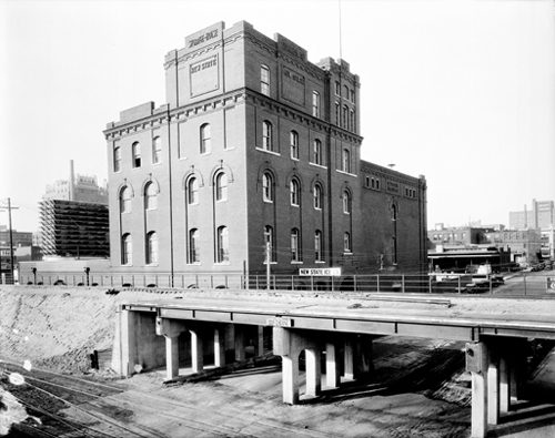
New State Ice Storage House
Address: 2 Northwest 2nd Street
View: Southwest
Date: before 1931

21412.M142.18, Z.P. Meyers/Barney Hillerman Photographic Collection, OHS (map #2X)
Hightower Building
Address: 105 North Hudson Avenue
View: Northwest
Date: July 1954
Architect: Hawk and Parr (Oklahoma Landmarks Inventory)
Built: 1920 (Oklahoma Landmarks Inventory)
"As Oklahoma City expanded, the central business district spread north and west. As a result of this movement, a three-story brick structure was built at the corner of Main and Hudson in 1920. Known as the Shops Building, the structure housed a variety of retail stores. In 1928 Frank P. Johnson, president of the American National Bank, purchased the building and added eight more levels. Later, the structure was acquired by Wilber E. Hightower, Johnson's son-in-law. Today, the ornate building appears much as it did in 1929." (Blackburn, Henderson and Thurman 69)

21412.M165.7, Z.P. Meyers/Barney Hillerman Photographic Collection, OHS (map #2Y)
The Biltmore Hotel
Address: 228 West Grand Avenue
View: Southeast
Date: October 1952
Architect: Hawk and Parr (Edwards and Ottaway, Vanished Splendor 49)
Built: 1932 (Edwards and Ottaway, Vanished Splendor 49)
Destroyed: 1977 (Lackmeyer 36)
"Located on the southeast corner of Grand and Harvey, the Biltmore Hotel was conceived and built during the Great Depression by prominent civic leaders, headed by Charles F. Colcord. Designed by architects Hawk and Parr, by the time it was completed in 1932, the Biltmore was thirty-three stories high and was heralded as the state's tallest building. Financial woes plagued the hotel throughout most of its life and the doors were closed in June 1973. Thousands of citizens turned out to watch as the massive structure was dynamited on October 16, 1977. Many cried openly, knowing that they were witnessing a singular episode of the destruction of historic Oklahoma City." (Edwards and Ottaway, Vanished Splendor 49)
"The Oklahoma Biltmore was without a doubt one of the finest hotels in the post-oil boom days of Oklahoma City. There were 619 rooms, each offering free radio, circulating ice water, ceiling fans with up-and-down draft, and later, air conditioning. In 1936 the Biltmore was headquarters for 104 conventions, served 284,604 meals, and had 114,171 guests! H.P. 'Johnnie' Johnson, manager, always said in the advertising, 'On your next visit to the Oil Capital be sure to register at the Biltmore.' 'On October 16, 1977 the Hotel Biltmore was demolished by a team of demolition specialists. Hundreds of low-yield explosives were planted throughout the building so that it would collapse and fall inward into an acceptable area only slightly larger than the hotel's foundation. The purpose was both to break the materials into smaller pieces that would be easily transported away, and to contain the blast and debris within the area, in order to minimize damage to surrounding structures. The razing was recorded by hundreds of camera buffs.'" (Edwards and Ottaway, Vanished Splendor II 287-288)
"After a $3 million renovation in the mid-1960s [the Biltmore] was renamed the Sheraton-Oklahoma Hotel. I.M. Pei envisioned keeping the hotel, and his sketches and models all showed the tower overlooking the surrounding 'Tivoli Gardens.' By 1973, the Sheraton brand was lost, and the Urban Renewal authority agreed with owners the Biltmore had outlived its useful life. The hotel was one of the largest demolitions in the country to date when it was blown up in 1977 to make way for the 'Myriad Gardens.'" (Lackmeyer and Money 36)

21412.M184.12, Z.P. Meyers/Barney Hillerman Photographic Collection, OHS (map #3A)
Oklahoma County Courthouse
Address: 321 Northwest 1st Street (Park Avenue)
View: Northeast
Date: September 1944
Architectural Style: PWA Deco (Lott 23)
Architect: Layton and Forsyth (Spangler)
Built: 1936-1937 (Lott 23)

21412.M192.4, Z.P. Meyers/Barney Hillerman Photographic Collection, OHS (map #3B)
U.S. Post Office
Address: Northwest 3rd Street between Harvey Avenue and Robinson Avenue
View: Northwest
Architect: James Knox Taylor (Lott 21)

21412.M195.2, Z.P. Meyers/Barney Hillerman Photographic Collection, OHS (map #3C)
Mercantile Building (Levy Building)
Address: 30 North Hudson Avenue
View: Southeast
Architect: Layton (Griffith 13)
Destroyed: February 29, 1976 (The Oklahoman; Date 1976 March 1; Page 1)
"Constructed as the Levy Building and later renamed the Mercantile Building, this five-story structure was located on the southeast corner of Main and Hudson. The office space was popular with attorneys, geologists, and real estate developers." (Edwards and Ottaway, Vanished Splendor 14)
"With 250 pounds of dynamite strategically placed inside the eight-story building, the Mercantile was expected to fall fairly easily….The building withstood three detonations before finally succumbing. 'Before each attempt, police nudged back the crowd which thronged the area, sirens shrieked and a loudspeaker sounded the countdown...three, two, one- but each time, nothing happened,' [Lynn] Hamilton reported." (Lackmeyer and Money 42)
"The Mercantile was built by the original owners, brothers Sam and Leon Levy, who constructed the first five stories in 1910. In 1926, they added three more floors." (The Oklahoman; Date 1976 March 1; Page 2)

21412.M210.3, Z.P. Meyers/Barney Hillerman Photographic Collection, OHS (map #3H)
Baum Building
Address: Grand (Sheridan Avenue) and Robinson Avenue
View: Northeast
Date: October 1950
Architectural Style: Venetian (Lackmeyer 29)
Architect: Layton and Smith (Edwards and Ottaway, Vanished Splendor 48)
Built: 1909 (Welge 16)
Destroyed: 1973 (Edwards and Ottaway, Vanished Splendor 48)
"Built in 1909 and completed by 1910, [the Baum Building] was patterned after the Doges Palace in Venice, Italy. It symbolized the growing economic boom after Oklahoma became a state. However, by the late 1960s, its fate was sealed with urban renewal as it was destroyed. Two of the cupolas have been preserved, one by the State Historical Society, the other by the Oklahoma City/County Historical Society." (Welge 16)
"The Baum Building, erected in 1910 at the northeast corner of Grand and Robinson, was a striking example of Italian-style architecture. The Doge's Palace in Venice is said to have provided architects Layton and Smith with the inspiration for its arches, towers, a vaulted ceilings, and marble veneer, all of which combined to make this one of the most beautiful commercial structures in the country. From 1923-1957, the Fidelity National Bank occupied the building. During these years the building carried the bank's name rather than that of the original owner. The wrecker's ball ended of existence of the Baum Building in 1973, although some of the decorative stone work has been preserved." (Edwards and Ottaway, Vanished Splendor 48)
"I.M. Pei wanted to clear the Venetian Style Baum Building in order to straighten Robinson Avenue." (Lackmeyer and Money 29)
"The Baum Building, patterned after the Doges Palace in Venice, Italy, was an early victim of urban renewal...To businessmen and investors during the early years of the century, functionalism in building design was not enough; their buildings had to be distinctive and unique. The original owners of the Baum building were the most successful in achieving that objective." (Blackburn, Henderson and Thurman 30)

21412.M211.3, Z.P. Meyers/Barney Hillerman Photographic Collection, OHS (map #3I)
Fidelity Bank / Park Harvey Apartments
Address: Northeast corner of Northwest 1st Street (Park Avenue) and Harvey Avenue
View: Northeast
Date: March 1958
This building was used for many years as headquarters for Kerr McGee. It recently was rehabilitated as inner city apartments.

21412.M221.5, Z.P. Meyers/Barney Hillerman Photographic Collection, OHS (map #3J)
Street View
View: North on Broadway Avenue
Date: October 4, 1947

21412.M234.4, Z.P. Meyers/Barney Hillerman Photographic Collection, OHS (map #3K)
Sooner Theatre
Address: 125 West Grand Avenue (Sheridan Avenue)
View: North
Date: August 1957

21412.M234.19, Z.P. Meyers/Barney Hillerman Photographic Collection, OHS (map #3L)
Street View
View: East on Main Street
Date: September 1944

21412.M258.6, Z.P. Meyers/Barney Hillerman Photographic Collection, OHS (map #3N)
Hotel Black
Address: 5–11 North Hudson Avenue
View: Northwest
Date: June 1947
Built: 1930 (Blackburn, Henderson and Thurman 76)
"The eleven story Black Hotel, constructed in 1930 by Lucian Black at a cost of $600,000, was only one of several ornate hotels constructed in Oklahoma City after the oil boom of 1928. Luring guests with a daily rate of $2 to $3 a day, the hotel for years competed with the Skirvin, Huckins, and Biltmore as the most appealing hotel in Oklahoma City. One feature which distinguished the Black from other hotels was its blend of geometric and Indian-design ornamentation. This unique design was continued on the American Motor Hotel directly to the north. Built by Oliver P. Kernadle, who pioneered the automobile hotel business in Oklahoma City, the eight-story structure housed automobiles for surrounding businesses, including the Black Hotel." (Blackburn, Henderson and Thurman 76)

21412.M264.1, Z.P. Meyers/Barney Hillerman Photographic Collection, OHS (map #3P)
Midwest Theatre
Address: 16 North Harvey Avenue
View: Northeast
Date: before 1930
"The Greek-born [John] Sinopoulos built the Midwest Theatre along Harvey between Main and Sheridan in the late 1920s. As the building was being torn down decades later, he could still remember the theatre's opening night. 'The ceiling was designed so that the 'stars' in it really blinked,' he said. "We released pigeons into the auditorium on the opening night and they landed everywhere, even on the paintings - it was a beautiful sight." Lackmeyer and Money 42)

21412.M281.1, Z.P. Meyers/Barney Hillerman Photographic Collection, OHS (map #3R)
Franklin Building
Address: 116 Northwest 2nd Street

21412.M299.2, Z.P. Meyers/Barney Hillerman Photographic Collection, OHS (map #3S)
Manly Office Supply Co.
Address: 214 West 1st Street (Park Avenue)
Date: ca. 1931-1936

21412.M308.1, Z.P. Meyers/Barney Hillerman Photographic Collection, OHS (map #3U)
Insurance Building
Address: 114 North Broadway Avenue
View: Northeast
Date: before 1930
Architect: Layton, Smith and Hawk (Griffith 61)
Built: 1910 (Griffith 53)
"Situated on the east side of the street at 114 North Broadway was the Insurance Building. Prior to its actual construction, various architectural firms drew plans for a building of similar size for this same space and postcards with these conceptions, labeled the Norton Building or the Bass and Harbour Building, still exist. Instead, the Insurance Building was constructed about 1910. The Oklahoma Gas & Electric Co. had offices to the south and in a short time the need for additional space led the company to extend its occupancy to the Insurance Building. People still recall the enormous electric sign on the roof with its hundreds of light bulbs spelling out 'Light & Power.' The building has been destroyed, and today its former site is part of the Santa Fe Plaza and Liberty Bank complex." (Edwards and Ottaway, Vanished Splendor 47)

21412.M312.7, Z.P. Meyers/Barney Hillerman Photographic Collection, OHS (map #3X)
Municipal Auditorium
Address: 201 North Walker Avenue
View: West
Date: October 1957
Architect: J.O. Parr (Spangler)
Built: 1937 (Lott 25)

21412.M322.2, Z.P. Meyers/Barney Hillerman Photographic Collection, OHS (map #3Z)
Capitol Federal Savings and Loan
Address: 302 North Robinson Avenue
Date: November 1955

21412.M322.6, Z.P. Meyers/Barney Hillerman Photographic Collection, OHS (map #4A)
Federal Reserve Bank
Address: 226 Northwest 3rd Street (3rd Street and Harvey Avenue)
View: East
Date: March 1960

21412.M322.13, Z.P. Meyers/Barney Hillerman Photographic Collection, OHS (map #4B)
Kerr-McGee Building
Address: Robinson and Northwest 2nd Street
View: Northeast
Date: March 1960

21412.M331.14, Z.P. Meyers/Barney Hillerman Photographic Collection, OHS (map #4C)
Patterson and Hoffman Wholesale Cigars and Pipes
Address: 10 West Main Street
Date: April 1953

21412.M341.2, Z.P. Meyers/Barney Hillerman Photographic Collection, OHS (map #4H)
Britling Cafeteria
Address: 221 Northwest 1st Street (Park Avenue)
Date: ca. 1938

21412.M352.44, Z.P. Meyers/Barney Hillerman Photographic Collection, OHS (map #4I)
Santa Fe Railroad Station
View: Southeast
Date: April 1944
Built: 1932 (Lott 34)

21412.M357.15, Z.P. Meyers/Barney Hillerman Photographic Collection, OHS (map #4J)
Bird's-Eye View of Civic Center and Oklahoma County Courthouse
View: West
Date: June 1956

21412.M358.1, Z.P. Meyers/Barney Hillerman Photographic Collection, OHS (map #4K)
Rockwall Apartments
Address: 424 Northwest 6th Street
View: Southeast

21412.M397.98, Z.P. Meyers/Barney Hillerman Photographic Collection, OHS (map #4M)
Parade on Broadway
View: North

21412.M432.2, Z.P. Meyers/Barney Hillerman Photographic Collection, OHS (map #4Q)
Public Warehouse Company
Address: 1 West Main Street
View: Northwest

21412.M480.2, Z.P. Meyers/Barney Hillerman Photographic Collection, OHS (map #4U)
Hotel Kingkade
Address: 17–19 West Grand Avenue (Sheridan Avenue)
View: Northeast
Built: 1912 (Edwards and Ottaway, Vanished Splendor 70-71)
"Andrew Kingkade arrived in Oklahoma City in 1908, intending to go into the insurance and mortgage loan business. He soon became interested in building a hotel with his friend E.L. Lawrence. Each man built his own hotel, both opening in 1912. Kingkade's was at 19 West Grand and the Lawrence Hotel at 17 West Grand. Calling itself a 'quiet refined place to stop when in Capitol City,' the new hotel evidently tried to distinguish itself from some of its more boisterous competitors. Political meetings made the Lee-Huckins, for instance, a lively spot, especially during the years immediately prior to statehood, but the Kingkade sought to establish a more sedate image, although a number of state legislators lived there, and a certain amount of politicking must have gone on. When it first opened, Lorenzo Rardin was president and Clarence T. Williams was vice president and manager….Originally an eight-story structure, the Kingkade soon expanded upward with the addition of three more floors, while the Lawrence remained the same height. After World War II the Kingkade gradually declined along with downtown hotels all over the country, until the coming of the Myriad Convention Center brought its history to an end. After the 1968 Thanksgiving dinner served in its coffee shop, the Kingkade ceased operations and was soon razed." (Edwards and Ottaway, Vanished Splendor 70-71)

21412.M534.2, Z.P. Meyers/Barney Hillerman Photographic Collection, OHS (map #4W)
Milner Hotel
Address: 15 West Grand Avenue (Sheridan Avenue)

21412.M545.1, Z.P. Meyers/Barney Hillerman Photographic Collection, OHS (map #4X)
Motor Hotel
Address: 17–19 North Hudson Avenue

21412.M928.2, Z.P. Meyers/Barney Hillerman Photographic Collection, OHS (map #4Y)
Gene Jones Motor Co.
Address: 709 North Broadway Avenue
Date: 1946

21412.M944.2, Z.P. Meyers/Barney Hillerman Photographic Collection, OHS (map #4Z)
Cotton-Exchange Building (Leonhardt Building)
Address: 218 North Harvey Avenue
View: Southeast
Date: August 1946
Architect: Hawk and Parr (Blackburn, Henderson and Thurman 57)
Built: 1923 (National Register of Historic Places in Oklahoma)
"As late as the early 1920s Oklahoma's economy still was predominately agricultural, with the cotton industry being the most important cash crop. By 1923, twenty-three cotton companies maintained purchasing agents in Oklahoma City, operating from dispersed buildings and offices. To centralize this specialized trade, city builder James W. Mann constructed the Cotton Exchange Building. For the design, Mann chose the architectural firm Hawk and Parr, which had gained a reputation with their design of the Masonic Temple in Guthrie and the Magnolia Petroleum Building in Oklahoma City. The building's role as a center for the cotton industry was short lived, however, for by 1930 the price of cotton had dropped more than 50% due to a combination of record harvests, declining markets, and economic depression. In 1945, with a few tenants associated with the cotton industry, the building was sold to H.E. Leonhardt, a local pioneer in the lumber industry. Today, the structure appears much as it did when it served the cotton trade in Oklahoma, a reminder of a past economic boom which equaled the importance of cattle and oil." (Blackburn, Henderson and Thurman 57)

21412.M944.10, Z.P. Meyers/Barney Hillerman Photographic Collection, OHS (map #5A)
Bird's-Eye View
View: Southeast
Date: July 1963

21412.M968.5, Z.P. Meyers/Barney Hillerman Photographic Collection, OHS (map #5B)
Street View
View: West on Grand Avenue toward Biltmore

21412.M1376.15, Z.P. Meyers/Barney Hillerman Photographic Collection, OHS (map #5D)
Street View
View: South on Robinson Avenue across Northwest 1st Street
Date: March 1950

21412.M203.1, Z.P. Meyers/Barney Hillerman Photographic Collection, OHS (map #5E)
Majestic Building
Address: 101–111 North Harvey Avenue
View: Northwest
Architect: J.W. Hawk (Edwards and Ottaway, Vanished Splendor 42)
Built: 1910 (Edwards and Ottaway, Vanished Splendor 42)
"The Majestic Building was designed by J. W. Hawk and built in 1910 by Tom O'Keefe, who specialized in reinforced concrete construction. This grand though narrow seven-story building was fireproof, had tile floors in its corridors and lobbies, was lighted by electricity, and steam heated by the vacuum system. The cornice was copper, with white terra cotta ornamentation. The walls were brick, and plans included 'ample provision for excellent ventilation.' While a few stores occupied the ground level, the upper floors were designed for office space." (Edwards and Ottaway, Vanished Splendor 42)

21412.M1393.3, Z.P. Meyers/Barney Hillerman Photographic Collection, OHS (map #5F)
Baltimore Building
Address: 2–12 North Harvey Avenue (Harvey Avenue and Grand)
Date: October 1944
"The Baltimore Building was on the busy northwest corner of Grand and Harvey and was serviced by two streetcar lines which met at this intersection. The Weaver & Seaver Druggists occupied the ground level for a number of years and offered drugs, cigars, and toilet articles on their counters and shelves. The 1910 City Directory reveals an ad that reads: 'Meet me at the Weaver Fountain,' which revives memories of the time when drugstores always featured the soda fountain with ice cream, cool drinks, and light lunches. The Draughon's Practical Business College was on the fifth floor. Other tenants included attorneys, real estate offices, and grain companies." (Edwards and Ottaway, Vanished Splendor 15)

21412.M3498.3, Z.P. Meyers/Barney Hillerman Photographic Collection, OHS (map #5H)
Federal Building
Address: 200 Northwest 4th Street
View: Southwest
Date: February 1963
Built: 1960 (Oklahoma Landmarks Inventory)

21412.M365.30, Z.P. Meyers/Barney Hillerman Photographic Collection, OHS (map #5I)
Skirvin Tower
Address: 101 Northwest 1st Street (Park Avenue)
View: Southeast
Architect: Layton, Hicks and Forsyth (Edwards, Oliphant and Ottaway 454)
"Construction of the Skirvin Tower at First and Broadway across the street from its sister hotel, the Skirvin, began in January 1931. Architects were Layton, Hicks and Forsyth. An underground tunnel connected the sister hotels...The hotel housed 'smart' shops on its lower floors. During the years of the Urban Renewal mania, the structure underwent a radical exterior face lifting, and today still stands as the modernistic-looking 101 Park Avenue Building." (Edwards, Oliphant and Ottaway 454)

21412.M156.12, Z.P. Meyers/Barney Hillerman Photographic Collection, OHS (map #5J)
Petroleum Building
Address: 218 North Robinson Avenue
View: Northeast
Date: ca. 1947
Architectural Style: Art Deco (Oklahoma Landmarks Inventory)
Architect: Layton and Forsyth (Edwards and Ottaway, Vanished Splendor 50)
Built: 1926 (Edwards and Ottaway, Vanished Splendor 50)
"Construction on the eighteen-story Petroleum Building was begun in 1926 and completed the following year on the corner of Northwest 2nd (Robert S. Kerr Avenue) and Robinson. Designed by Layton and Forsyth, the structure was built of marble, stone and terra cotta brick. The façade is Coldstream granite from Minnesota, and Rosata marble, quarried in Italy, was used to finish the walls in the lobby. On top of this skyscraper was an illuminated fifty foot high oil derrick that could be seen for a distance of fifteen miles from Oklahoma City. At night it was lit with colored lights. The building continues to be used although the name has been changed..." (Edwards and Ottaway, Vanished Splendor 50)

21412.M58.1, Z.P. Meyers/Barney Hillerman Photographic Collection, OHS (map #5L)
Campbell Building
Address: 10 North Broadway Avenue
View: Northeast
Date: October 1942
Architect: Frank D. Hyde (Griffith 105)
Built: 1926
"The Campbell Building at 10 North Broadway appears to be squeezed into space left between the Lee-Huckins Annex on the north and the Wells Fargo Company on the south. Designed by Chicago architect Frank D. Hyde, it was twenty-five feet by forty feet and was eleven stories high. The structural parts were entirely of reinforced concrete, the 'Kahn System,' with the façade being finished in white Portland cement. The ground floors above were devoted to offices. Two elevators were in service and its 'fireproof construction throughout' was a selling point to anyone seeking office space...the Lee-Huckins Hotel [was] rebuilt after it burned to the ground in August, 1908." (Edwards and Ottaway, Vanished Splendor 44)

21412.M78.1, Z.P. Meyers/Barney Hillerman Photographic Collection, OHS (map #5M)
Ford Motor Company Assembly Plant
Address: 900 West Main Street
View: Southwest
(Lott 31)Built: 1915 (Griffith 95)
"Vehicle assembly in the building was divided between the floors, with automobiles working their way upward, and then back down. The first floor contained the motor and chassis assembly, as well as the showroom." (Lott 31)
21412.BH579, Z.P. Meyers/Barney Hillerman Photographic Collection, OHS (map #5N)
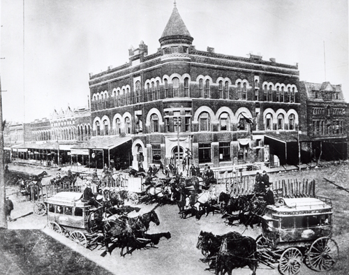
Masonic Temple
Address: 101 West Main Street (Main Street and Broadway Avenue)
View: Northwest
"This grand, round-cornered three-story building served a multitude of occupants over the years, and in 1902 one of the upper floors was indeed the Masonic Temple...Located on the northwest corner of Main and Broadway, the ground floor level was the home of the Western National Bank. Diagonally across the street from the Lee-Huckins Hotel, this building was certainly located on one of the busier intersections in Oklahoma City. It survived until 1923, when it was demolished to make way for construction of an office building." (Edwards and Ottaway, Vanished Splendor 91)

21412.BH696.1, Z.P. Meyers/Barney Hillerman Photographic Collection, OHS (map #5S)
Old County Courthouse
Address: 520 West Main Street (Main Street and Dewey)
View: Southeast
Architectural Style: Massive Romanesque (Edwards and Ottaway, Vanished Splendor, inside cover)
Architect: Willam A. Wells and George Burlinghof (Edwards and Ottaway, Vanished Splendor, inside cover)
Built: 1906 (Edwards and Ottaway, Vanished Splendor, inside cover)
Destroyed: 1950 (Edwards and Ottaway, Vanished Splendor, inside cover)
"Perhaps no other building symbolizes Oklahoma more than the Oklahoma County Courthouse. Construction began on November 4, 1904, and was completed in 1906. It was designed by architects William A. Wells and his partner George Burlinghof in a style designated as Massive Romanesque. No sooner had plans been announced and the plot of land acquired, than a controversy developed between the business interests on Main and Grand. Each street had influential spokesmen and each side wanted the Court House to face on its street. A compromise was finally reached and the building was placed so that it faced west on Dewey between Grand and Main. In reality this meant that few people actually used the front entrance, but opted for the preferred side and back entrances instead. Exterior walls were constructed of Indiana limestone with the interior floors of granite and the walls and stairways of Vermont marble. The city literally outgrew the building and quite soon after it was completed, governing agencies were forced to rent office space in buildings outside of the Courthouse. The County moved in 1938 to a new Court House that was built in the Civic Center complex. The old Court House building was used by the federal government to house a group of wartime agencies during World War II, but a fire in 1944 caused the building to be abandoned and boarded up. Demolition began late in 1950 and was completed the following year. The land was used for a time as a parking lot and later sold to the Holiday Inn Corporation for a downtown motel." (Edwards and Ottaway, Vanished Splendor, interior cover)

21412.BH1796.3, Z.P. Meyers/Barney Hillerman Photographic Collection, OHS (map #5T)
Skirvin Hotel
Address: 1 Northwest 1st (Park Avenue)
Date: July 1963
Architect: Solomon Layton (Griffith 13)
Built: 1911 (Lott 17)
"When ground was broken for the hotel bearing oilman W.B. Skirvin's name, the structure was planned to stand just six stories tall. By the time the doors opened, that grew to 10, and in 1930, rose again to 14 floors, for a total of 525 rooms." (Lott 17)

21412.M397.11, Z.P. Meyers/Barney Hillerman Photographic Collection, OHS (map #5X)
Masonic Temple (Home State Life Building, Journal Record Building)
Address: Northwest 6th Street and Robinson Avenue
Date: April 1941

21412.M439.15, Z.P. Meyers/Barney Hillerman Photographic Collection, OHS (map #5Y)
Lerner
Address: 321 West Main Street
Date: February 1954

21412.M158.7, Z.P. Meyers/Barney Hillerman Photographic Collection, OHS (map #5Z)
Kress
Address: 218 West Main Street
View: Northeast
Date: November 1948
Built: 1910 (Griffith 57)
"Prior to statehood, the S.H. Kress & Co. opened for business in [a] small three-story building. By 1910, the store had expanded to incorporate the Illinois Hotel building." " (Griffith 57)

21412.M196.65, Z.P. Meyers/Barney Hillerman Photographic Collection, OHS (map #6A)
Aerial View
Address: Broadway Circle
View: South
Date: October 1959

21412.M97.2, Z.P. Meyers/Barney Hillerman Photographic Collection, OHS (map #6B)
Plaza Court
Address: 1100 Classen Drive
View: North
Architect: Hawk and Parr (National Register of Historic Places in Oklahoma)
Built: 1927 (National Register of Historic Places in Oklahoma)
Click points or areas on the map to view historic photographs of downtown Oklahoma City.
- •
- Ford Assembling Plant
- •
- Municipal Auditorium
- •
- Bird’s Eye View of Civic Center and Courthouse
- •
- Old County Courthouse
- •
- Montgomery Ward Building
- •
- Hotel Black
- •
- Motor Hotel
- •
- Plaza Court
- •
- Gene Jones Motor Co.
- •
- Magnolia Petroleum Company
- •
- Rockwell Apartments
- •
- Masonic Temple (Home State Life Building)
- •
- Kirkpatrick Hotel
- •
- Elks Lodge (Key Building, ONG Building)
- •
- Federal Building
- •
- US Post Office
- •
- Federal Reserve Bank
- •
- Cotton-Exchange Building
- •
- Oklahoma County Courthouse
- •
- YWCA
- •
- Hightower Building
- •
- Mercantile Building (Levy Building)
- •
- Majestic Building
- •
- First National Building
- •
- Wright Building
- •
- Skirvin Tower
- •
- Rock Island Railroad Depot
- •
- Skirvin Hotel
- •
- Insurance Building
- •
- Public Warehouse Company
- •
- Patterson and Hoffman Wholesale Cigars and Pipes
- •
- Milner Hotel
- •
- Hotel Kingkade
- •
- Herskowitz Building
- •
- Santa Fe Railroad Station
- •
- Wells Roberts Hotel
- •
- Sooner Theatre
- •
- Colcord Building
- •
- Baltimore Building
- •
- Midwest Theatre
- •
- Kress
- •
- Lerner
- •
- Katz Drug
- •
- The American National Building
- •
- Empire Building
- •
- Criterion Theatre
- •
- Biltmore Hotel
- •
- Oklahoma Club Building
- •
- Farmer's National Bank Building
- •
- Commerce Exchange Building
- •
- Huckins Hotel, Huckins Garage
- •
- Campbell Building
- •
- Hales Building
- •
- Fidelity Bank
- •
- Britling Cafeteria
- •
- Manly Office Supply Company
- •
- Perrine Building, Cravens Building
- •
- Baum Building
- •
- Security National Building
- •
- Ramsey Tower, City National Building
- •
- Petroleum Building
- •
- Franklin Building
- •
- Braniff Building
- •
- Kerr-McGee Building
- •
- Capitol Federal Savings and Loan
- •
- Telephone, Pioneer, Southwestern Bell
- •
- Street View
- •
- Street View
- •
- Street View
- •
- Street View
- •
- Street View
- •
- Street View
- •
- Street View
- •
- Street View
- •
- Street View
- •
- Parade on Broadway
- •
- Street View
- •
- Street View
- •
- Aerial View
- •
- Bird’s Eye View
- •
- Bird’s Eye View
- •
- Bird’s Eye View
The Z. P. Meyers/Barney Hillerman Photographic Collection
The Z. P. Meyers/Barney Hillerman Photographic Collection includes thousands of images, many of which depict businesses in Oklahoma City. Many photographs in the collection are from the Meyers Photo Shop, which employed Barney Hillerman and other photographers. This map highlights significant buildings in the downtown Oklahoma City area, as well as street and aerial views. The map features images dating from the late 1920s to the 1960s.
This project was made possible by a grant from the Pauline Dwyer Macklanburg and Robert A. Macklanburg Jr. Foundation.
You can view more images from the Z. P. Meyers/Barney Hillerman Photographic Collection on The Gateway to Oklahoma History.
Visit The Gateway to Oklahoma History.