
Home | About OHS | Historical Marker Program
Location: 1/2 mile east of junction of OK-8 and OK-11, north of Cherokee
Coordinates: 36.805565, -98.245647
Material: Stone with bronze plaque
Topics: American Indians, Government, Environmental/Cultural Ecology, Settlement Patterns
Sibley, an Osage Indian agent, and two others were believed to be the first whites to view the Great Salt Plains on an expedition to the area in the summer of 1811. Sibley called the geological phenomenon "a perfect level plain covered in dry hot weather from two to six inches deep with a beautiful clean white salt.
Location: on the northwest corner of Sod House Museum grounds
Coordinates: 36.472370, -98.426225
Location: on OK-8, five miles north of Cleo Springs at Sod House Museum
Coordinates: 36.472189, -98.425992
Material: Granite
Topics: Settlement Patterns, Environmental/Cultural Ecology, Territorial Period 1861–1907, Agriculture, Land Openings
This is the only complete, restored, and intact sod house remaining in Oklahoma. As Oklahoma was settled, homesteaders cut long furrows of sod into blocks and stacked them to form walls. Openings were left for windows and doors. Thousands of sod houses once dotted the prairie but eventually were destroyed by the harsh climate of the Great Plains. This house, constructed by Marshall McCully, was protected by trees and a frame building.
Location: on OK-11, two miles east of junction with US-64, north of Cherokee
Coordinates: 36.797050, -98.324543
Material: Aluminum
Topics: Religion/Philosophy, Territorial Period 1861–1907, Education, Settlement Patterns, Transportation
Buildings near here from 1897. Under auspices of Friends Church, the Academy was noted for high moral, spiritual and scholastic standards. Closed 1922. Named for the teacher of first school (1893) in this vicinity, a sod house near Stella Church in Cherokee Strip.
Le Flore County
Lincoln County
Logan County
Love County
Marshall County
Mayes County
McClain County
McCurtain County
McIntosh County
Murray County
Muskogee County
Noble County
Okfuskee County
Oklahoma County
Okmulgee County
Osage County
Ottawa County
Pawnee County
Payne County
Pittsburg County
Pontotoc County
Pottawatomie County
Pushmataha County
Roger Mills County
Rogers County
Seminole County
Sequoyah County
Stephens County
Texas County
Tillman County
Tulsa County
Wagoner County
Washington County
Washita County
Woods County
Woodward County
Historical Marker Program
Search Results
Your search returned 4 results.
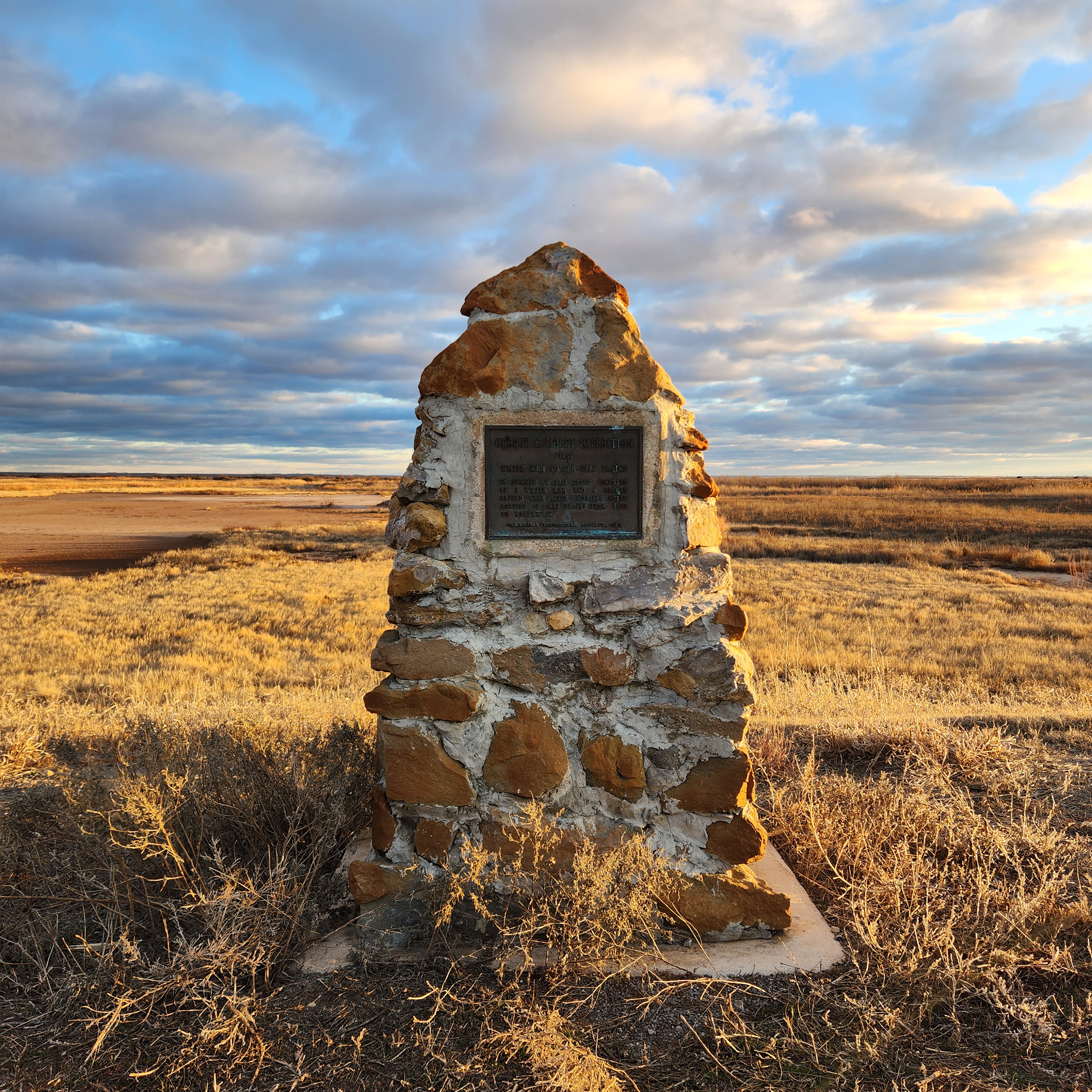
George C. Sibley Expedition
Alfalfa CountyLocation: 1/2 mile east of junction of OK-8 and OK-11, north of Cherokee
Coordinates: 36.805565, -98.245647
Material: Stone with bronze plaque
Topics: American Indians, Government, Environmental/Cultural Ecology, Settlement Patterns
Sibley, an Osage Indian agent, and two others were believed to be the first whites to view the Great Salt Plains on an expedition to the area in the summer of 1811. Sibley called the geological phenomenon "a perfect level plain covered in dry hot weather from two to six inches deep with a beautiful clean white salt.
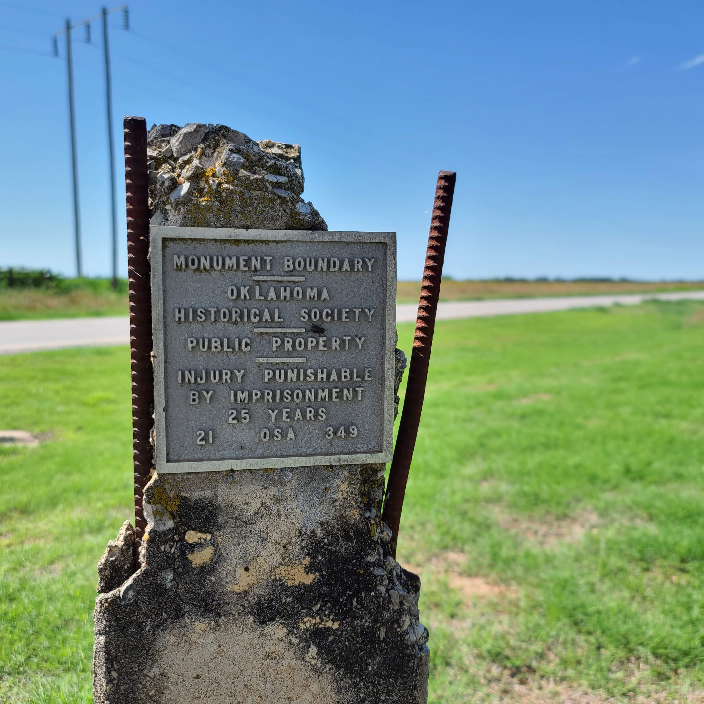
Monument Boundary
Alfalfa CountyLocation: on the northwest corner of Sod House Museum grounds
Coordinates: 36.472370, -98.426225
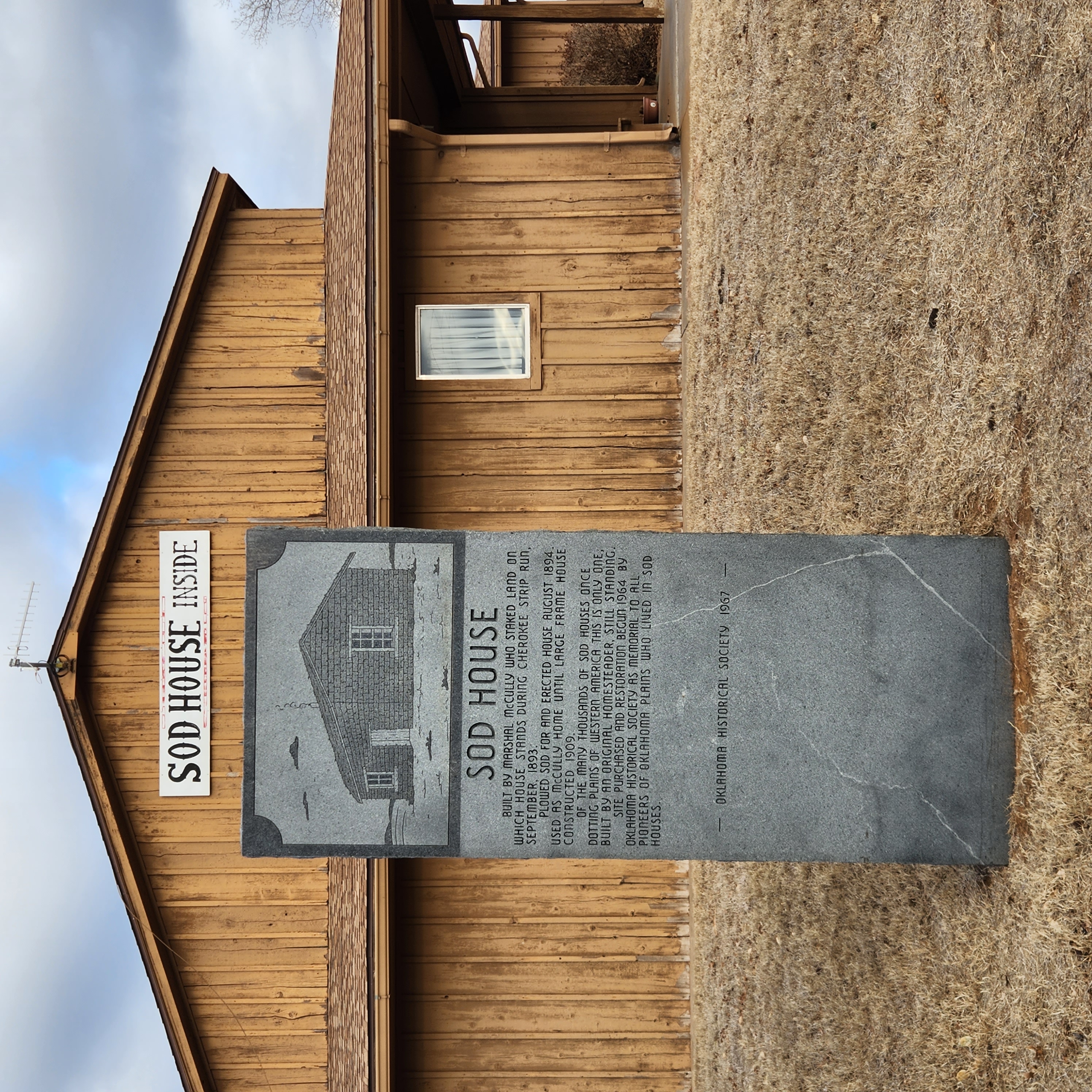
Sod House
Alfalfa CountyLocation: on OK-8, five miles north of Cleo Springs at Sod House Museum
Coordinates: 36.472189, -98.425992
Material: Granite
Topics: Settlement Patterns, Environmental/Cultural Ecology, Territorial Period 1861–1907, Agriculture, Land Openings
This is the only complete, restored, and intact sod house remaining in Oklahoma. As Oklahoma was settled, homesteaders cut long furrows of sod into blocks and stacked them to form walls. Openings were left for windows and doors. Thousands of sod houses once dotted the prairie but eventually were destroyed by the harsh climate of the Great Plains. This house, constructed by Marshall McCully, was protected by trees and a frame building.
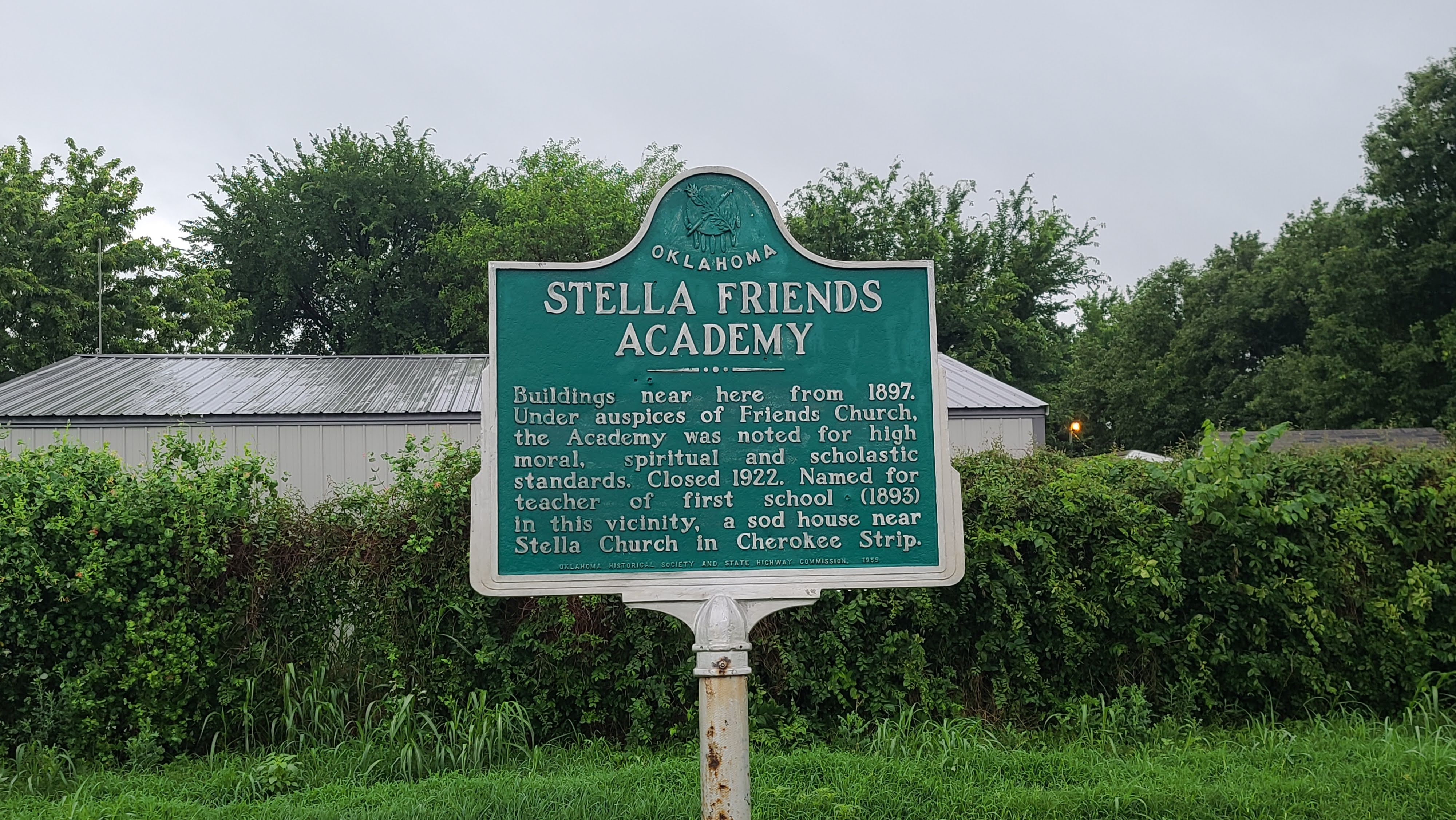
Stella Friends Academy
Alfalfa CountyLocation: on OK-11, two miles east of junction with US-64, north of Cherokee
Coordinates: 36.797050, -98.324543
Material: Aluminum
Topics: Religion/Philosophy, Territorial Period 1861–1907, Education, Settlement Patterns, Transportation
Buildings near here from 1897. Under auspices of Friends Church, the Academy was noted for high moral, spiritual and scholastic standards. Closed 1922. Named for the teacher of first school (1893) in this vicinity, a sod house near Stella Church in Cherokee Strip.
(Page 1 of 1)
Search for Markers
Search by keyword or browse by county to learn about more than 600 historical markers created to recognize key locations, events, and people in Oklahoma history.
Please note that some markers listed in this database may have been moved, damaged, or are no longer standing.
Browse by County
Adair County
Alfalfa County
Atoka County
Beaver County
Beckham County
Blaine County
Bryan County
Caddo County
Canadian County
Carter County
Cherokee County
Choctaw County
Cimarron County
Cleveland County
Comanche County
Cotton County
Craig County
Creek County
Custer County
Delaware County
Dewey County
Ellis County
Garfield County
Garvin County
Grady County
Grant County
Greer County
Harmon County
Harper County
Haskell County
Hughes County
Jackson County
Jefferson County
Johnston County
Kay County
Kingfisher County
Kiowa County
Latimer CountyAlfalfa County
Atoka County
Beaver County
Beckham County
Blaine County
Bryan County
Caddo County
Canadian County
Carter County
Cherokee County
Choctaw County
Cimarron County
Cleveland County
Comanche County
Cotton County
Craig County
Creek County
Custer County
Delaware County
Dewey County
Ellis County
Garfield County
Garvin County
Grady County
Grant County
Greer County
Harmon County
Harper County
Haskell County
Hughes County
Jackson County
Jefferson County
Johnston County
Kay County
Kingfisher County
Kiowa County
Le Flore County
Lincoln County
Logan County
Love County
Marshall County
Mayes County
McClain County
McCurtain County
McIntosh County
Murray County
Muskogee County
Noble County
Okfuskee County
Oklahoma County
Okmulgee County
Osage County
Ottawa County
Pawnee County
Payne County
Pittsburg County
Pontotoc County
Pottawatomie County
Pushmataha County
Roger Mills County
Rogers County
Seminole County
Sequoyah County
Stephens County
Texas County
Tillman County
Tulsa County
Wagoner County
Washington County
Washita County
Woods County
Woodward County
Contact Us
If you have questions, please contact:
Matthew Pearce
Oklahoma Historical Society
800 Nazih Zuhdi Drive
Oklahoma City, OK 73105
405-522-8659
matthew.pearce@history.ok.gov