
Home | About OHS | Historical Marker Program
Location: on OK-66 in Texola
Material: Aluminum
Topics: Government, Settlement Patterns
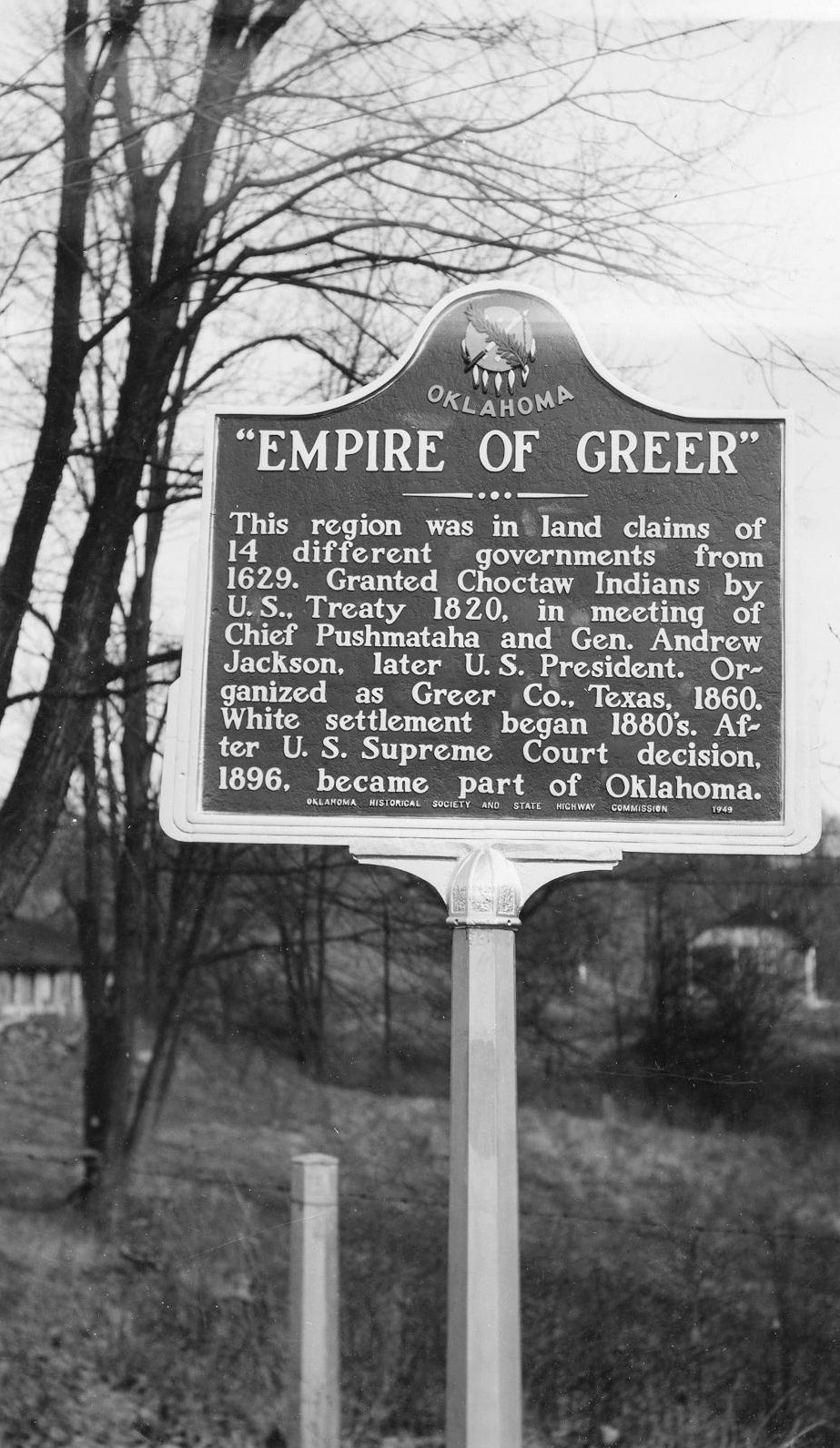
This marker is on the 100th Meridian, now the west boundary of Oklahoma. Under the terms of the Adams-Onis Treaty of 1819 it was the international boundary between the United States and Spanish Territory. Ownership of Old Greer County (the area between the North Fork of Red River and Red River) was claimed by fourteen different governments from 1629 to 1896 when the US Supreme Court declared the area part of Oklahoma Territory.
Location: four miles south and one mile west of intersection of OK-6 and 152 south of Elk City
Material: Granite
Topics: Retail, Territorial Period 1861–1907, Early Statehood 1907–1941, Education
The Highway community was founded in 1892. At one time the town contained two general stores, a barber shop, a blacksmith shop, and a grain mill. A new consolidated school building was dedicated in 1922. The school closed in 1957.
Location: on US H66, in the roadside park, one mile south of Sayre
Topics: Empire Period 1541–1803, Settlement Patterns, Government
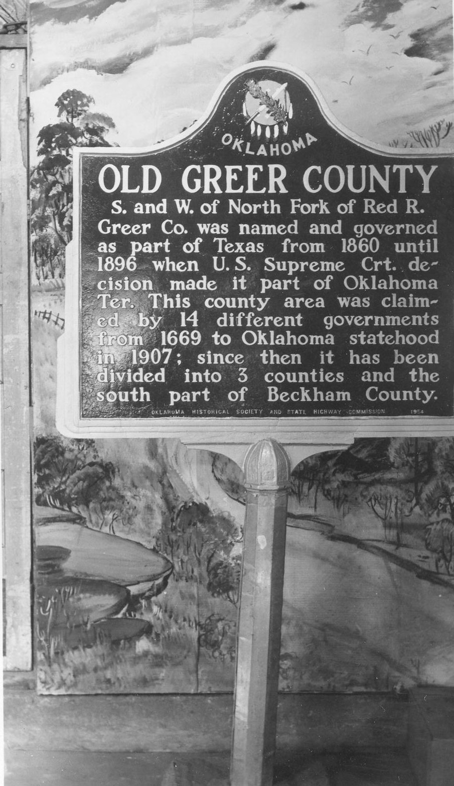
Greer County was named and governed as part of Texas from 1860 until 1896 when a US Supreme Court decision made it part of Oklahoma Territory. This county area was claimed by fourteen different governments from 1669 to Oklahoma statehood in 1907; since then it has been divided into three counties and the south part of Beckham County.
Location: on Hwy 283 north of Sayre
Sponsored by: Chrissy MacDougall c/o Charlies Abernathy
Topics: Empire Period 1541–1803, Transportation, Government, Indian and Frontier Trade
The Spaniards developed the first-known trail in Oklahoma. Deep, indelible ruts were cut into the prairie by heavily laden wooden carts. Known as the Great Spanish Road to Red River, it connected Santa Fe and Natchitoches. The real beginning of highway construction was under Governor Holloway with Alvin Moore as State Senator.
Le Flore County
Lincoln County
Logan County
Love County
Marshall County
Mayes County
McClain County
McCurtain County
McIntosh County
Murray County
Muskogee County
Noble County
Okfuskee County
Oklahoma County
Okmulgee County
Osage County
Ottawa County
Pawnee County
Payne County
Pittsburg County
Pontotoc County
Pottawatomie County
Pushmataha County
Roger Mills County
Rogers County
Seminole County
Sequoyah County
Stephens County
Texas County
Tillman County
Tulsa County
Wagoner County
Washington County
Washita County
Woods County
Woodward County
Historical Marker Program
Search Results
Your search returned 4 results.
Empire of Greer
Beckham CountyLocation: on OK-66 in Texola
Material: Aluminum
Topics: Government, Settlement Patterns
This marker is on the 100th Meridian, now the west boundary of Oklahoma. Under the terms of the Adams-Onis Treaty of 1819 it was the international boundary between the United States and Spanish Territory. Ownership of Old Greer County (the area between the North Fork of Red River and Red River) was claimed by fourteen different governments from 1629 to 1896 when the US Supreme Court declared the area part of Oklahoma Territory.
HWY-OK
Beckham CountyLocation: four miles south and one mile west of intersection of OK-6 and 152 south of Elk City
Material: Granite
Topics: Retail, Territorial Period 1861–1907, Early Statehood 1907–1941, Education
The Highway community was founded in 1892. At one time the town contained two general stores, a barber shop, a blacksmith shop, and a grain mill. A new consolidated school building was dedicated in 1922. The school closed in 1957.
Old Greer County
Beckham CountyLocation: on US H66, in the roadside park, one mile south of Sayre
Topics: Empire Period 1541–1803, Settlement Patterns, Government
Greer County was named and governed as part of Texas from 1860 until 1896 when a US Supreme Court decision made it part of Oklahoma Territory. This county area was claimed by fourteen different governments from 1669 to Oklahoma statehood in 1907; since then it has been divided into three counties and the south part of Beckham County.
Spanish Road Crossing
Beckham CountyLocation: on Hwy 283 north of Sayre
Sponsored by: Chrissy MacDougall c/o Charlies Abernathy
Topics: Empire Period 1541–1803, Transportation, Government, Indian and Frontier Trade
The Spaniards developed the first-known trail in Oklahoma. Deep, indelible ruts were cut into the prairie by heavily laden wooden carts. Known as the Great Spanish Road to Red River, it connected Santa Fe and Natchitoches. The real beginning of highway construction was under Governor Holloway with Alvin Moore as State Senator.
(Page 1 of 1)
Search for Markers
Search by keyword or browse by county to learn about more than 600 historical markers created to recognize key locations, events, and people in Oklahoma history.
Please note that some markers listed in this database may have been moved, damaged, or are no longer standing.
Browse by County
Adair County
Alfalfa County
Atoka County
Beaver County
Beckham County
Blaine County
Bryan County
Caddo County
Canadian County
Carter County
Cherokee County
Choctaw County
Cimarron County
Cleveland County
Comanche County
Cotton County
Craig County
Creek County
Custer County
Delaware County
Dewey County
Ellis County
Garfield County
Garvin County
Grady County
Grant County
Greer County
Harmon County
Harper County
Haskell County
Hughes County
Jackson County
Jefferson County
Johnston County
Kay County
Kingfisher County
Kiowa County
Latimer CountyAlfalfa County
Atoka County
Beaver County
Beckham County
Blaine County
Bryan County
Caddo County
Canadian County
Carter County
Cherokee County
Choctaw County
Cimarron County
Cleveland County
Comanche County
Cotton County
Craig County
Creek County
Custer County
Delaware County
Dewey County
Ellis County
Garfield County
Garvin County
Grady County
Grant County
Greer County
Harmon County
Harper County
Haskell County
Hughes County
Jackson County
Jefferson County
Johnston County
Kay County
Kingfisher County
Kiowa County
Le Flore County
Lincoln County
Logan County
Love County
Marshall County
Mayes County
McClain County
McCurtain County
McIntosh County
Murray County
Muskogee County
Noble County
Okfuskee County
Oklahoma County
Okmulgee County
Osage County
Ottawa County
Pawnee County
Payne County
Pittsburg County
Pontotoc County
Pottawatomie County
Pushmataha County
Roger Mills County
Rogers County
Seminole County
Sequoyah County
Stephens County
Texas County
Tillman County
Tulsa County
Wagoner County
Washington County
Washita County
Woods County
Woodward County
Contact Us
If you have questions, please contact:
Matthew Pearce
Oklahoma Historical Society
800 Nazih Zuhdi Drive
Oklahoma City, OK 73105
405-522-8659
matthew.pearce@history.ok.gov