
Home | About OHS | Historical Marker Program
Location: on Sunset Drive in Ardmore
Topics: Urban Development, Transportation
Ardmore's beginning is traced to the establishment of the 700 Ranch. In 1870, the Roff log house was the first building erected within what would become the city limits of Ardmore. The house was moved to its present site in 1991.
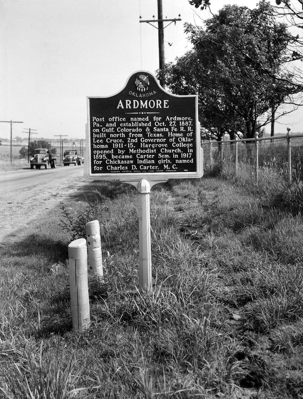
Location: on US Highway 77, north of Ardmore, Carter County
Topics: Religion/Philosophy, Education, American Indians, Territorial Period 1861–1907, Government
The Ardmore post office was named for Ardmore, Pennsylvania, and established on October 27, 1887, on the Gulf, Colorado & Santa Fe Railroad, built north from Texas. Ardmore was the home of Lee Cruce, second governor of Oklahoma from 1911–1915. Hargrove College was opened by the Methodist Church in 1895 and became Carter Seminary in 1917 for Chickasaw girls. It was named for Charles D. Carter, M.C.
Location: on OK-53, on the corner of Ardmore Industrial Airpark (See Ardmore Army Air Field)
Topics: Transportation, Military, Modern Period 1982–present
On April 22, 1966, six soldiers and a crew of six died when an American Flyers Company Electra turboprop airplane crashed in the Arbuckle Mountains about "two miles and two hills" east of the Ardmore Airpark. Seventeen survived the crash. The plane was en route from Fort Ord, California, to Fort Benning, Georgia.
Location: at Ardmore Industrial Airpark, seven miles east of Exit 40 on I-35
Topics: Military, Industrial Period 1841–1892
The Ardmore Army Air Field base was built to train airmen from 1942 to 1946. From 1953 to 1958, the facility was known as the Ardmore Air Force Base. A nearby marker honors the trainees who were casualties in World War II and the Korean War.
Location: at 117 West Broadway in Ardmore
Topics: Urban Development, Early Statehood 1907–1941, Social/Cultural, Retail
This five-story building erected in 1930 was originally called the Gilbert Building. Four radio stations, a television station, law offices, dentists, and the Ardmore Little Theater have called the building home.
Location: at 100 West Main Street in Ardmore
Topics: Petroleum, Territorial Period 1861–1907, Social/Cultural
Built in 1905, the building became a casual meeting place for early oil men seeking deals.
Location: on Poolville Road, six miles north of OK-53
Coordinates: 34.419800, -97.399538
Material: Aluminum
Topics: Territorial Period 1861–1907, Government
In 1894, US Marshal Selden Lindsey shot famous outlaw Bill Dalton here.
Location: one mile north of US-77 and OK-142 in Ardmore
Topics: Natural Resources
On the ten-mile stretch of US-77 north of Ardmore are markers noting the unique geological features of the area. The markers include the Woodford Shale and Chert Outcropping, Chimney Hill Limestone Outcropping, Viola Limestone Outcropping, Tulip Creek and Third Bromide Sandstone Outcropping, Basil McLish Sandstone Outcropping, and the Arbuckle-West Spring Creek Lime Outcropping.
Location: in Lake Murray State Park
Material: Granite
Topics: Early Statehood 1907–1941, Recreational/Service, Government
The men of the Civilian Conservation Corps (CCC) Companies 1813 and 849 lived and worked in a camp during the Great Depression and built Lake Murray State Park. The CCC was a make-work program created by Congress at the suggestion of President Franklin D. Roosevelt to help alleviate the shortage of jobs in America. Three hundred young men worked for seven years carving the rock for the Lake Murray dam, built shelters, picnic tables, roads, and trails and landscaped the park.
Location: at 107 East Main in Ardmore
Topics: Urban Development, Retail
Established at this location in the early twentieth century, the Daube's Department Store was the cornerstone around which Ardmore was built. The business closed in 1990 after 102 years as Oklahoma's oldest, privately owned, family-operated business.
Location: at 15 East Main in Ardmore
Topics: Government, Early Statehood 1907–1941
This sidewalk stone recounts the infamous shooting of US Marshal Dow Brazil by Deputy Sheriff Bud Ballew in 1918.
Location: in Lake Murray State Park
Topics: Transportation
E. J. Johnson designed the Memorial Bridge at Lake Murray
Location: in Greater Southwest Historical Museum, 35 Sunset Drive, Ardmore
Topics: Family/Household, Territorial Period 1861–1907, Petroleum
James Eaves built this one-room log cabin in 1898 and later added a second room. The cabin is typical of a pioneer home in southern Oklahoma. The Brady family, descendants of James Eaves, donated the cabin to the museum. It was disassembled and rebuilt in the museum in 2000. In the area adjacent to the museum is a marker honoring early oil well drillers.
Location: at 200 West Main in Ardmore
Topics: Government, Territorial Period 1861–1907
Carter County's only official hanging took place outside the jail that was built in 1898.
Location: at 15 West Main in Ardmore
Topics: Industry/Business
Ardmore's oldest financial institution occupied this building from 1918 to 1975.
Location: at OK-76 and Fourth Street in Healdton
Topics: Petroleum, Early Statehood 1907–1941
In 1913, Wirt Franklin brought this well in, marking the beginning of the great Healdton Field discovery. The well produced 100 barrels a day at 1,076 feet.
Location: at 500 Lake Murray Drive Southeast in Ardmore
Topics: Ranching, Early Statehood 1907–1941, Social/Cultural
Hardy Murphy gained international fame with his training of Buck, Silver Cloud, and other horses from 1930 to 1943. Ardmore's coliseum is named for Murphy.
Location: at 9th Avenue and D Street Northwest in Ardmore
Topics: Religion/Philosophy, Territorial Period 1861–1907, Education
Named for Bishop Robert H. Hargrove, this Methodist college was established here in 1894. After it burned in 1907, the college was rebuilt north of Ardmore.
Location: on OK-76 in Healdton
Topics: Urban Development, Petroleum, Government, Territorial Period 1861–1907, Early Statehood 1907–1941
Healdton was named for prominent citizen C. H. Healdton. The first post office was established in 1883. The Healdton Oil Field (1913) made the area one of the famous oil drilling sites in Oklahoma.
Location: at 15 North Washington in Ardmore
Topics: Industry/Business, Recreational/Service, Territorial Period 1861–1907, American Indians
Hotel Wisnor, a fifty-room, three-story hotel built in 1884, was named in honor of Benjamin Wisnor Carter, the prominent Chickasaw Indian for whom Carter County is named. In 1903, the Carter-Booker Building was constructed at this location, providing offices for the Cotton Exchange.
Location: on US-70 at Daisy Lane in Dickson
Topics: Arts
Joseph Callaway gained international recognition as a director, critic, and Shakespearean actor.
Location: at entrance to lodge in Lake Murray State Park
Topics: Industry/Business, Recreational/Service, Industrial Period 1841–1892
Lake Murray Lodge was built in 1951 during the administration of Governor Roy Turner.
Location: at 500 Lake Murray Drive Southeast in Ardmore
Topics: Industry/Business, Transportation, Early Statehood 1907–1941
Locomotive 1108 brought doctors and nurses to Ardmore after the 1915 explosion that leveled most of the town's downtown business district.
Location: at 214 West Main in Ardmore
Topics: Retail, Territorial Period 1861–1907, Transportation
In 1893, E. B. Luke opened his store that sold everything from victrolas to pianos. He kept six teams of horses and mules to deliver pianos and organs to customers.
Location: at 1 West Main in Ardmore
Topics: Industry/Business, Social/Cultural, Territorial Period 1861–1907
Built in 1896, the First National Bank originally occupied the first two floors of the Masonic Temple Building with the Masons on the third floor. Later, the Masons used the entire building and converted the third floor into a ballroom that served Ardmore residents for social events for many years.
Location: at 128 West Main in Ardmore
Topics: Petroleum, Retail, Territorial Period 1861–1907
Noble Brothers Hardware moved to this location in 1902 from East Main Street. One of the brothers, Sam, was the father of Lloyd Noble, who established the Noble Drilling Company, Samedan Oil Company, and the Samuel Roberts Noble Foundation.
Location: across from Noble Foundation campus in Ardmore
Topics: Agriculture, Government, Family/Household, Early Statehood 1907–1941
The two-story Noble farmhouse was built in 1922 on land originally allotted by the Dawes Commission.
Location: at 2610 Noble Parkway in Ardmore
Topics: Recreational/Service, Industrial Period 1841–1892
Dedicated in 1952, the core of this building remains the oldest operational building on the campus of the Noble Foundation.
Location: at Healdton Oil Museum
Topics: Petroleum, Government
Healdtown was the first oilfield regulated by the Oklahoma Corporation Commission.
Location: on county road seven miles west and one mile north of exit 42 on I-35
During the settlement of Oklahoma, early travelers used this water. Later residents used the water for medicinal, drinking, and household needs.
Location: at 209 West Main in Ardmore
Topics: Folklife, Early Statehood 1907–1941, Government, Petroleum, Social/Cultural
Jake Hamon was shot in the Randol Hotel where huge oil deals were consummated. The hotel burned in 1925.
Location: at US-70 and Daisy Lane in Dickson
Topics: American Indians, Arts
Rosella Hightower is one of the state's five American Indian prima ballerinas depicted in a mural in the State Capitol in Oklahoma City. A world-renowned Chickasaw ballerina, she was born near Dickson.
Location: at 400 West Main in Ardmore
Topics: Petroleum, Industrial Period 1841–1892
Noble Drilling Corporation secretly sent Oklahoma drilling crews to tap oil under the Sherwood Forest in England in 1943 during World War II.
Location: in community of Tatums
Topics: Ethnic Diversity, Territorial Period 1861–1907, Early Statehood 1907–1941
Tatums is one of thirteen All-Black towns, out of more than fifty that once existed, remaining in Oklahoma. While Tullahassee is reportedly the oldest, most were established between 1889 and 1907 as African Americans sought security and control of their destiny in a segregated world. Most of the towns began to decline in the 1920s and 1930s as rural African Americans faced economic hardships and began to move to urban areas. Tatums was established in 1896 and is named for Lee Tatum, the first postmaster and a United States marshal.
Le Flore County
Lincoln County
Logan County
Love County
Marshall County
Mayes County
McClain County
McCurtain County
McIntosh County
Murray County
Muskogee County
Noble County
Okfuskee County
Oklahoma County
Okmulgee County
Osage County
Ottawa County
Pawnee County
Payne County
Pittsburg County
Pontotoc County
Pottawatomie County
Pushmataha County
Roger Mills County
Rogers County
Seminole County
Sequoyah County
Stephens County
Texas County
Tillman County
Tulsa County
Wagoner County
Washington County
Washita County
Woods County
Woodward County
Historical Marker Program
Search Results
Your search returned 34 results.
700 Ranch House
Carter CountyLocation: on Sunset Drive in Ardmore
Topics: Urban Development, Transportation
Ardmore's beginning is traced to the establishment of the 700 Ranch. In 1870, the Roff log house was the first building erected within what would become the city limits of Ardmore. The house was moved to its present site in 1991.
Ardmore
Carter CountyLocation: on US Highway 77, north of Ardmore, Carter County
Topics: Religion/Philosophy, Education, American Indians, Territorial Period 1861–1907, Government
The Ardmore post office was named for Ardmore, Pennsylvania, and established on October 27, 1887, on the Gulf, Colorado & Santa Fe Railroad, built north from Texas. Ardmore was the home of Lee Cruce, second governor of Oklahoma from 1911–1915. Hargrove College was opened by the Methodist Church in 1895 and became Carter Seminary in 1917 for Chickasaw girls. It was named for Charles D. Carter, M.C.
Ardmore Air Crash
Carter CountyLocation: on OK-53, on the corner of Ardmore Industrial Airpark (See Ardmore Army Air Field)
Topics: Transportation, Military, Modern Period 1982–present
On April 22, 1966, six soldiers and a crew of six died when an American Flyers Company Electra turboprop airplane crashed in the Arbuckle Mountains about "two miles and two hills" east of the Ardmore Airpark. Seventeen survived the crash. The plane was en route from Fort Ord, California, to Fort Benning, Georgia.
Ardmore Army Air Field
Carter CountyLocation: at Ardmore Industrial Airpark, seven miles east of Exit 40 on I-35
Topics: Military, Industrial Period 1841–1892
The Ardmore Army Air Field base was built to train airmen from 1942 to 1946. From 1953 to 1958, the facility was known as the Ardmore Air Force Base. A nearby marker honors the trainees who were casualties in World War II and the Korean War.
Ardmoreite Building
Carter CountyLocation: at 117 West Broadway in Ardmore
Topics: Urban Development, Early Statehood 1907–1941, Social/Cultural, Retail
This five-story building erected in 1930 was originally called the Gilbert Building. Four radio stations, a television station, law offices, dentists, and the Ardmore Little Theater have called the building home.
Bankers National Bank Building
Carter CountyLocation: at 100 West Main Street in Ardmore
Topics: Petroleum, Territorial Period 1861–1907, Social/Cultural
Built in 1905, the building became a casual meeting place for early oil men seeking deals.
Bill Dalton Killing
Carter CountyLocation: on Poolville Road, six miles north of OK-53
Coordinates: 34.419800, -97.399538
Material: Aluminum
Topics: Territorial Period 1861–1907, Government
In 1894, US Marshal Selden Lindsey shot famous outlaw Bill Dalton here.
Bostwick Conglomerate Outcropping
Carter CountyLocation: one mile north of US-77 and OK-142 in Ardmore
Topics: Natural Resources
On the ten-mile stretch of US-77 north of Ardmore are markers noting the unique geological features of the area. The markers include the Woodford Shale and Chert Outcropping, Chimney Hill Limestone Outcropping, Viola Limestone Outcropping, Tulip Creek and Third Bromide Sandstone Outcropping, Basil McLish Sandstone Outcropping, and the Arbuckle-West Spring Creek Lime Outcropping.
CCC-Lake Murray State Park
Carter CountyLocation: in Lake Murray State Park
Material: Granite
Topics: Early Statehood 1907–1941, Recreational/Service, Government
The men of the Civilian Conservation Corps (CCC) Companies 1813 and 849 lived and worked in a camp during the Great Depression and built Lake Murray State Park. The CCC was a make-work program created by Congress at the suggestion of President Franklin D. Roosevelt to help alleviate the shortage of jobs in America. Three hundred young men worked for seven years carving the rock for the Lake Murray dam, built shelters, picnic tables, roads, and trails and landscaped the park.
Daube's Department Store
Carter CountyLocation: at 107 East Main in Ardmore
Topics: Urban Development, Retail
Established at this location in the early twentieth century, the Daube's Department Store was the cornerstone around which Ardmore was built. The business closed in 1990 after 102 years as Oklahoma's oldest, privately owned, family-operated business.
Dow Brazil Killing
Carter CountyLocation: at 15 East Main in Ardmore
Topics: Government, Early Statehood 1907–1941
This sidewalk stone recounts the infamous shooting of US Marshal Dow Brazil by Deputy Sheriff Bud Ballew in 1918.
E. J. Johnson
Carter CountyLocation: in Lake Murray State Park
Topics: Transportation
E. J. Johnson designed the Memorial Bridge at Lake Murray
Eaves-Brady Log Cabin
Carter CountyLocation: in Greater Southwest Historical Museum, 35 Sunset Drive, Ardmore
Topics: Family/Household, Territorial Period 1861–1907, Petroleum
James Eaves built this one-room log cabin in 1898 and later added a second room. The cabin is typical of a pioneer home in southern Oklahoma. The Brady family, descendants of James Eaves, donated the cabin to the museum. It was disassembled and rebuilt in the museum in 2000. In the area adjacent to the museum is a marker honoring early oil well drillers.
Federal Courthouse and Jail
Carter CountyLocation: at 200 West Main in Ardmore
Topics: Government, Territorial Period 1861–1907
Carter County's only official hanging took place outside the jail that was built in 1898.
First National Bank
Carter CountyLocation: at 15 West Main in Ardmore
Topics: Industry/Business
Ardmore's oldest financial institution occupied this building from 1918 to 1975.
Franklin No. 1
Carter CountyLocation: at OK-76 and Fourth Street in Healdton
Topics: Petroleum, Early Statehood 1907–1941
In 1913, Wirt Franklin brought this well in, marking the beginning of the great Healdton Field discovery. The well produced 100 barrels a day at 1,076 feet.
Hardy Murphy
Carter CountyLocation: at 500 Lake Murray Drive Southeast in Ardmore
Topics: Ranching, Early Statehood 1907–1941, Social/Cultural
Hardy Murphy gained international fame with his training of Buck, Silver Cloud, and other horses from 1930 to 1943. Ardmore's coliseum is named for Murphy.
Hargrove College
Carter CountyLocation: at 9th Avenue and D Street Northwest in Ardmore
Topics: Religion/Philosophy, Territorial Period 1861–1907, Education
Named for Bishop Robert H. Hargrove, this Methodist college was established here in 1894. After it burned in 1907, the college was rebuilt north of Ardmore.
Healdton Oil Museum
Carter CountyLocation: on OK-76 in Healdton
Topics: Urban Development, Petroleum, Government, Territorial Period 1861–1907, Early Statehood 1907–1941
Healdton was named for prominent citizen C. H. Healdton. The first post office was established in 1883. The Healdton Oil Field (1913) made the area one of the famous oil drilling sites in Oklahoma.
Hotel Wisnor/Carter-Booker Building
Carter CountyLocation: at 15 North Washington in Ardmore
Topics: Industry/Business, Recreational/Service, Territorial Period 1861–1907, American Indians
Hotel Wisnor, a fifty-room, three-story hotel built in 1884, was named in honor of Benjamin Wisnor Carter, the prominent Chickasaw Indian for whom Carter County is named. In 1903, the Carter-Booker Building was constructed at this location, providing offices for the Cotton Exchange.
Joseph Callaway
Carter CountyLocation: on US-70 at Daisy Lane in Dickson
Topics: Arts
Joseph Callaway gained international recognition as a director, critic, and Shakespearean actor.
Lake Murray Lodge
Carter CountyLocation: at entrance to lodge in Lake Murray State Park
Topics: Industry/Business, Recreational/Service, Industrial Period 1841–1892
Lake Murray Lodge was built in 1951 during the administration of Governor Roy Turner.
Locomotive 1108
Carter CountyLocation: at 500 Lake Murray Drive Southeast in Ardmore
Topics: Industry/Business, Transportation, Early Statehood 1907–1941
Locomotive 1108 brought doctors and nurses to Ardmore after the 1915 explosion that leveled most of the town's downtown business district.
Luke's Music Store
Carter CountyLocation: at 214 West Main in Ardmore
Topics: Retail, Territorial Period 1861–1907, Transportation
In 1893, E. B. Luke opened his store that sold everything from victrolas to pianos. He kept six teams of horses and mules to deliver pianos and organs to customers.
Masonic Temple Building
Carter CountyLocation: at 1 West Main in Ardmore
Topics: Industry/Business, Social/Cultural, Territorial Period 1861–1907
Built in 1896, the First National Bank originally occupied the first two floors of the Masonic Temple Building with the Masons on the third floor. Later, the Masons used the entire building and converted the third floor into a ballroom that served Ardmore residents for social events for many years.
Noble Brothers Hardware
Carter CountyLocation: at 128 West Main in Ardmore
Topics: Petroleum, Retail, Territorial Period 1861–1907
Noble Brothers Hardware moved to this location in 1902 from East Main Street. One of the brothers, Sam, was the father of Lloyd Noble, who established the Noble Drilling Company, Samedan Oil Company, and the Samuel Roberts Noble Foundation.
Noble Farmhouse
Carter CountyLocation: across from Noble Foundation campus in Ardmore
Topics: Agriculture, Government, Family/Household, Early Statehood 1907–1941
The two-story Noble farmhouse was built in 1922 on land originally allotted by the Dawes Commission.
Noble Foundation
Carter CountyLocation: at 2610 Noble Parkway in Ardmore
Topics: Recreational/Service, Industrial Period 1841–1892
Dedicated in 1952, the core of this building remains the oldest operational building on the campus of the Noble Foundation.
Oklahoma's First Regulated Oilfield
Carter CountyLocation: at Healdton Oil Museum
Topics: Petroleum, Government
Healdtown was the first oilfield regulated by the Oklahoma Corporation Commission.
Old Sulphur Spring
Carter CountyLocation: on county road seven miles west and one mile north of exit 42 on I-35
During the settlement of Oklahoma, early travelers used this water. Later residents used the water for medicinal, drinking, and household needs.
Randol Hotel
Carter CountyLocation: at 209 West Main in Ardmore
Topics: Folklife, Early Statehood 1907–1941, Government, Petroleum, Social/Cultural
Jake Hamon was shot in the Randol Hotel where huge oil deals were consummated. The hotel burned in 1925.
Rosella Hightower
Carter CountyLocation: at US-70 and Daisy Lane in Dickson
Topics: American Indians, Arts
Rosella Hightower is one of the state's five American Indian prima ballerinas depicted in a mural in the State Capitol in Oklahoma City. A world-renowned Chickasaw ballerina, she was born near Dickson.
Sherwood Forest
Carter CountyLocation: at 400 West Main in Ardmore
Topics: Petroleum, Industrial Period 1841–1892
Noble Drilling Corporation secretly sent Oklahoma drilling crews to tap oil under the Sherwood Forest in England in 1943 during World War II.
Tatums
Carter CountyLocation: in community of Tatums
Topics: Ethnic Diversity, Territorial Period 1861–1907, Early Statehood 1907–1941
Tatums is one of thirteen All-Black towns, out of more than fifty that once existed, remaining in Oklahoma. While Tullahassee is reportedly the oldest, most were established between 1889 and 1907 as African Americans sought security and control of their destiny in a segregated world. Most of the towns began to decline in the 1920s and 1930s as rural African Americans faced economic hardships and began to move to urban areas. Tatums was established in 1896 and is named for Lee Tatum, the first postmaster and a United States marshal.
(Page 1 of 1)
Search for Markers
Search by keyword or browse by county to learn about more than 600 historical markers created to recognize key locations, events, and people in Oklahoma history.
Please note that some markers listed in this database may have been moved, damaged, or are no longer standing.
Browse by County
Adair County
Alfalfa County
Atoka County
Beaver County
Beckham County
Blaine County
Bryan County
Caddo County
Canadian County
Carter County
Cherokee County
Choctaw County
Cimarron County
Cleveland County
Comanche County
Cotton County
Craig County
Creek County
Custer County
Delaware County
Dewey County
Ellis County
Garfield County
Garvin County
Grady County
Grant County
Greer County
Harmon County
Harper County
Haskell County
Hughes County
Jackson County
Jefferson County
Johnston County
Kay County
Kingfisher County
Kiowa County
Latimer CountyAlfalfa County
Atoka County
Beaver County
Beckham County
Blaine County
Bryan County
Caddo County
Canadian County
Carter County
Cherokee County
Choctaw County
Cimarron County
Cleveland County
Comanche County
Cotton County
Craig County
Creek County
Custer County
Delaware County
Dewey County
Ellis County
Garfield County
Garvin County
Grady County
Grant County
Greer County
Harmon County
Harper County
Haskell County
Hughes County
Jackson County
Jefferson County
Johnston County
Kay County
Kingfisher County
Kiowa County
Le Flore County
Lincoln County
Logan County
Love County
Marshall County
Mayes County
McClain County
McCurtain County
McIntosh County
Murray County
Muskogee County
Noble County
Okfuskee County
Oklahoma County
Okmulgee County
Osage County
Ottawa County
Pawnee County
Payne County
Pittsburg County
Pontotoc County
Pottawatomie County
Pushmataha County
Roger Mills County
Rogers County
Seminole County
Sequoyah County
Stephens County
Texas County
Tillman County
Tulsa County
Wagoner County
Washington County
Washita County
Woods County
Woodward County
Contact Us
If you have questions, please contact:
Matthew Pearce
Oklahoma Historical Society
800 Nazih Zuhdi Drive
Oklahoma City, OK 73105
405-522-8659
matthew.pearce@history.ok.gov