
Home | About OHS | Historical Marker Program
Location: on OK-325, 16 miles west and 3 1/2 miles north of Boise City
Topics: Religion/Philosophy, Settlement Patterns, Westward Expansion 1803–1861
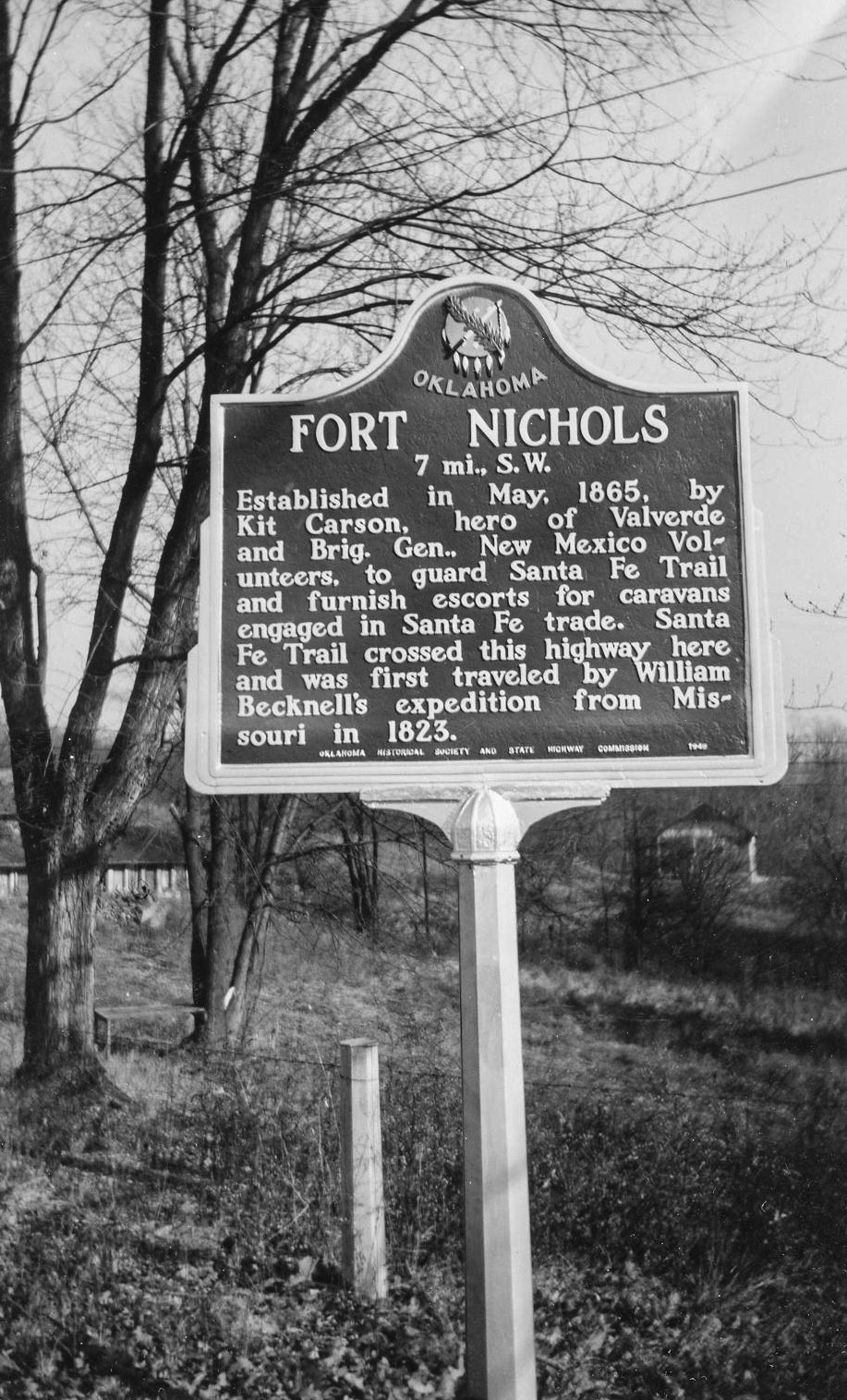
Frontier legend Kit Carson established Fort Nichols in 1865 to guard travelers along the Santa Fe Trail. Stone buildings were constructed. Troops occupied the fort for less than a year. One can see a fine trace of the Santa Fe Trail from the site.
Location: on the Santa Fe Trail northwest of Boise
The Mormon Battalion crossed into present-day Oklahoma on September 19, 1846, and camped just north and west of Boise City enroute to Mexico as part of General Kearney's Army during the War with Mexico. When they reached Mexico the war was over. The Army was ordered to form a trail to San Diego. At San Diego they built a courthouse. They were then ordered to Los Angeles, then back to San Diego, where they were discharged.
Location: on OK-325, 16 miles west and 3 1/2 miles north of Boise City
Material: Granite
Topics: Transportation, Indian and Frontier Trade, Westward Expansion 1803–1861, Territorial Period 1861–1907
The Santa Fe Trail provided one of the earliest contacts with the Southwest. Running 780 miles from Independence, Missouri, to Santa Fe, New Mexico, it cut across the Oklahoma Panhandle and became an important trade route that was patrolled by army troops. The heaviest traffic came in 1849 as Easterners headed for the gold fields in California. The trail remained in use until the railroads came in 1880.
Location: on county road at Oklahoma-New Mexico state line 27 miles west and one mile south of Boise City (DAR)
Sponsored by: Daughters of the American Revolution
See Santa Fe Trail
Location: on OK-287, nine miles north of Boise City.
See Santa Fe Trail
Le Flore County
Lincoln County
Logan County
Love County
Marshall County
Mayes County
McClain County
McCurtain County
McIntosh County
Murray County
Muskogee County
Noble County
Okfuskee County
Oklahoma County
Okmulgee County
Osage County
Ottawa County
Pawnee County
Payne County
Pittsburg County
Pontotoc County
Pottawatomie County
Pushmataha County
Roger Mills County
Rogers County
Seminole County
Sequoyah County
Stephens County
Texas County
Tillman County
Tulsa County
Wagoner County
Washington County
Washita County
Woods County
Woodward County
Historical Marker Program
Search Results
Your search returned 5 results.
Fort Nichols
Cimarron CountyLocation: on OK-325, 16 miles west and 3 1/2 miles north of Boise City
Topics: Religion/Philosophy, Settlement Patterns, Westward Expansion 1803–1861
Frontier legend Kit Carson established Fort Nichols in 1865 to guard travelers along the Santa Fe Trail. Stone buildings were constructed. Troops occupied the fort for less than a year. One can see a fine trace of the Santa Fe Trail from the site.
Mormon Battalion
Cimarron CountyLocation: on the Santa Fe Trail northwest of Boise
The Mormon Battalion crossed into present-day Oklahoma on September 19, 1846, and camped just north and west of Boise City enroute to Mexico as part of General Kearney's Army during the War with Mexico. When they reached Mexico the war was over. The Army was ordered to form a trail to San Diego. At San Diego they built a courthouse. They were then ordered to Los Angeles, then back to San Diego, where they were discharged.
Santa Fe Trail
Cimarron CountyLocation: on OK-325, 16 miles west and 3 1/2 miles north of Boise City
Material: Granite
Topics: Transportation, Indian and Frontier Trade, Westward Expansion 1803–1861, Territorial Period 1861–1907
The Santa Fe Trail provided one of the earliest contacts with the Southwest. Running 780 miles from Independence, Missouri, to Santa Fe, New Mexico, it cut across the Oklahoma Panhandle and became an important trade route that was patrolled by army troops. The heaviest traffic came in 1849 as Easterners headed for the gold fields in California. The trail remained in use until the railroads came in 1880.
Santa Fe Trail
Cimarron CountyLocation: on county road at Oklahoma-New Mexico state line 27 miles west and one mile south of Boise City (DAR)
Sponsored by: Daughters of the American Revolution
See Santa Fe Trail
Santa Fe Trail
Cimarron CountyLocation: on OK-287, nine miles north of Boise City.
See Santa Fe Trail
(Page 1 of 1)
Search for Markers
Search by keyword or browse by county to learn about more than 600 historical markers created to recognize key locations, events, and people in Oklahoma history.
Please note that some markers listed in this database may have been moved, damaged, or are no longer standing.
Browse by County
Adair County
Alfalfa County
Atoka County
Beaver County
Beckham County
Blaine County
Bryan County
Caddo County
Canadian County
Carter County
Cherokee County
Choctaw County
Cimarron County
Cleveland County
Comanche County
Cotton County
Craig County
Creek County
Custer County
Delaware County
Dewey County
Ellis County
Garfield County
Garvin County
Grady County
Grant County
Greer County
Harmon County
Harper County
Haskell County
Hughes County
Jackson County
Jefferson County
Johnston County
Kay County
Kingfisher County
Kiowa County
Latimer CountyAlfalfa County
Atoka County
Beaver County
Beckham County
Blaine County
Bryan County
Caddo County
Canadian County
Carter County
Cherokee County
Choctaw County
Cimarron County
Cleveland County
Comanche County
Cotton County
Craig County
Creek County
Custer County
Delaware County
Dewey County
Ellis County
Garfield County
Garvin County
Grady County
Grant County
Greer County
Harmon County
Harper County
Haskell County
Hughes County
Jackson County
Jefferson County
Johnston County
Kay County
Kingfisher County
Kiowa County
Le Flore County
Lincoln County
Logan County
Love County
Marshall County
Mayes County
McClain County
McCurtain County
McIntosh County
Murray County
Muskogee County
Noble County
Okfuskee County
Oklahoma County
Okmulgee County
Osage County
Ottawa County
Pawnee County
Payne County
Pittsburg County
Pontotoc County
Pottawatomie County
Pushmataha County
Roger Mills County
Rogers County
Seminole County
Sequoyah County
Stephens County
Texas County
Tillman County
Tulsa County
Wagoner County
Washington County
Washita County
Woods County
Woodward County
Contact Us
If you have questions, please contact:
Matthew Pearce
Oklahoma Historical Society
800 Nazih Zuhdi Drive
Oklahoma City, OK 73105
405-522-8659
matthew.pearce@history.ok.gov