
Home | About OHS | Historical Marker Program
Location: on East Taft Avenue near South Division Street in Sapulpa (DAR)
Sponsored by: Daughters of the American Revolution
Topics: Social/Cultural, American Indians, Indian and Frontier Trade, Territorial Period 1861–1907
Chief Sapulpa Cemetery, one block south of the marker, is named for a full-blood Creek Indian named "Chief" Sapulpa, although he was not a chief. He owned an early trading post and was a Confederate officer in the Civil War. His real name was Sepulcher, but over time the name became corrupted to Sapulpa. The local DAR chapter purchased the burial ground in 1923.
Location: on corner of Coonrod Drive and SH-51, Mannford
Sponsored by: Keystone Crossroads Historical Society
Topics: Environmental/Cultural Ecology, American Indians, Government, Folklife
Located approximately 3.3 miles west is a cave where, according to the 1930s WPA Guide to Oklahoma, Creek Indian Tom Bartee sheltered and fed the Daltons when they were pursued by deputy US marshals.
Location: on grounds of Sapulpa Junior High School at Lee Avenue and Mission Street
Material: Granite
Topics: Religion/Philosophy, Education, Territorial Period 1861–1907, Industrial Period 1841–1892
In 1891, the Presbyterian Mission Board established a school for the children of Euchees in the area. The school opened with fifty students in 1894 and was located one mile east of Sapulpa. Euchee and Methodist minister Noah Gregory was the first superintendent of the school. The school closed in 1947, and the land and buildings were sold to the local public school district.
Location: two miles southeast of Drumright
Sponsored by: Leonard Shelton
Topics: Petroleum, Industry/Business
The Jackson Barnett #11 oil well was the first oil well in the world to produce one million barrels of oil in a one year period. It is on the National Register of Historic Places.
Location: east site of SH-48, north the 48/51 junction at the turnoff into old Mannford Ramp Park
Topics: Settlement Patterns, Transportation, American Indians
The original townsite of Mannford began 1/4 mile east of the creek headrights of Tom and Hazel Mann. The town was named for Mann's Ford across the Cimarron River in 1895. G. M. Evans leased this ninety acres and surrounding land. The Arkansas Valley and Western Railway (AV&W RR/Frisco) came in 1902, and a post office was established on April 11, 1903. Hall C. Miller bought the ninety acres for the townsite on February 21, 1906. The townsite was relocated in 1962–63 due to the Keystone Dam.
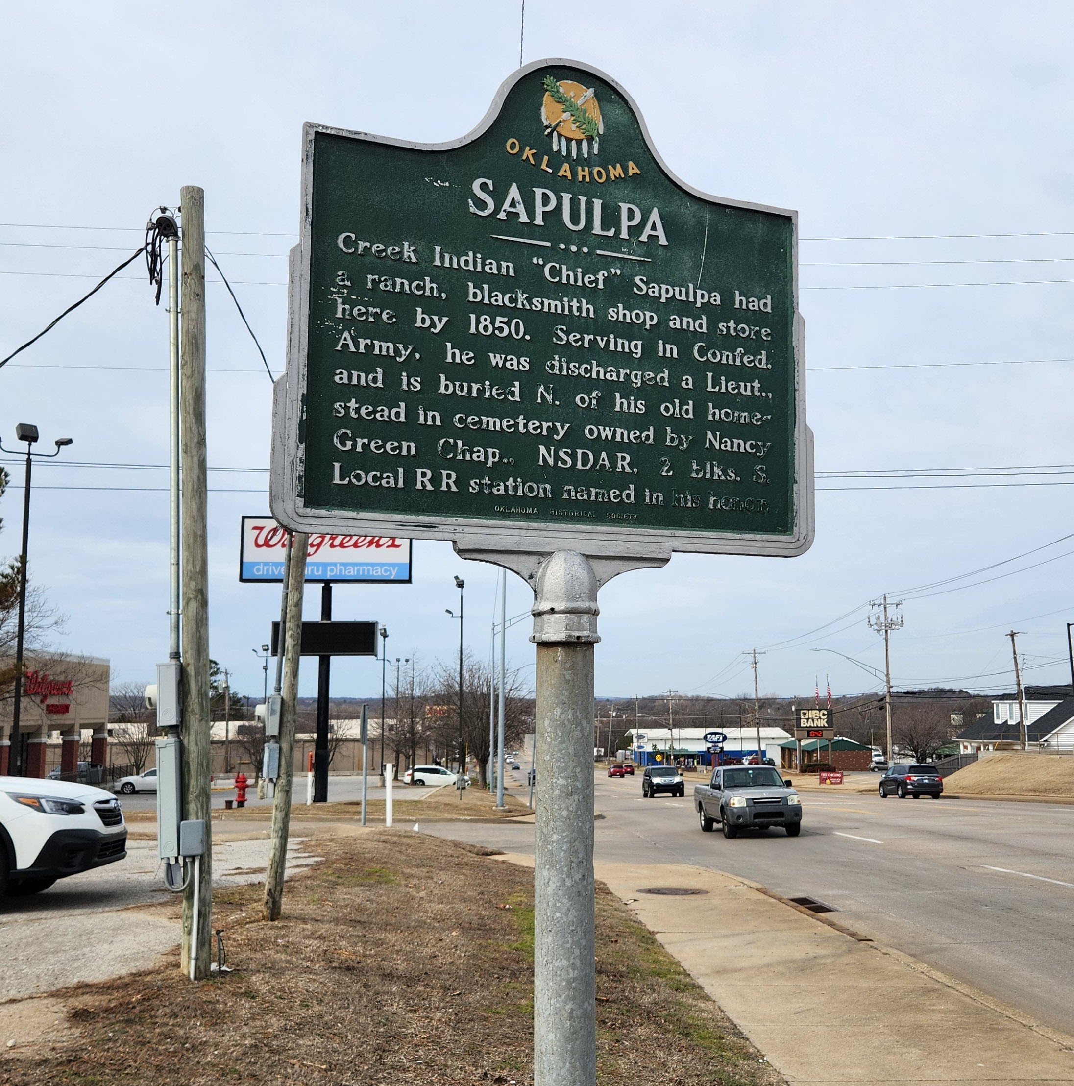
Location: Near the corner of Taft Avenue and Division Street in Sapulpa
Coordinates: 35.988244, -96.100699
Material: Aluminum
Topics: American Indians, Military, Westward Expansion 1803–1861, Settlement Patterns, Social/Cultural
Creek Indian "Chief" Sapulpa had a ranch, blacksmith shop, and store here by 1850. Serving in Confederate Army, he was discharged a lieutenant, and is buried north of his old homestead in a cemetery owned by the Nancy Green Chapter, NSDAR.
Location: one mile west and 1/2 mile north of Intersection of US-75 and 171st Street on Tulsa/Creek County Road.
Material: Aluminum
Topics: Transportation, American Indians, Territorial Period 1861–1907, Retail
Twin Mounds Cemetery was named for the prominent landmark 3/4 mile northeast of where the town of Twin Mounds sat. The town was moved to a new place in 1903 as the railroad bypassed the first site. William Gilcrease ran the store in Posey, and Tom Gilcrease's allotment was nearby.
Location: one mile west and 1/2 mile north of intersection of US-75 and 171st Street on Tulsa/Creek County Road.
Material: Aluminum
Topics: Social/Cultural, American Indians, Transportation, Retail, Petroleum
This was the first cemetery in the area. Twin Mounds, first called Posey for Creek poet Alex Posey, sat 3/4 mile northeast between mounds used as landmarks. The town moved to Mounds in 1903 when the railroad bypassed it. William Gilcrease owned the store in Posey; Thomas Gilcrease's allotment was 1/4 mile north. Glenn Pool oil find of 1905 started the boom.
Le Flore County
Lincoln County
Logan County
Love County
Marshall County
Mayes County
McClain County
McCurtain County
McIntosh County
Murray County
Muskogee County
Noble County
Okfuskee County
Oklahoma County
Okmulgee County
Osage County
Ottawa County
Pawnee County
Payne County
Pittsburg County
Pontotoc County
Pottawatomie County
Pushmataha County
Roger Mills County
Rogers County
Seminole County
Sequoyah County
Stephens County
Texas County
Tillman County
Tulsa County
Wagoner County
Washington County
Washita County
Woods County
Woodward County
Historical Marker Program
Search Results
Your search returned 8 results.
Chief Sapulpa Cemetery
Creek CountyLocation: on East Taft Avenue near South Division Street in Sapulpa (DAR)
Sponsored by: Daughters of the American Revolution
Topics: Social/Cultural, American Indians, Indian and Frontier Trade, Territorial Period 1861–1907
Chief Sapulpa Cemetery, one block south of the marker, is named for a full-blood Creek Indian named "Chief" Sapulpa, although he was not a chief. He owned an early trading post and was a Confederate officer in the Civil War. His real name was Sepulcher, but over time the name became corrupted to Sapulpa. The local DAR chapter purchased the burial ground in 1923.
Dalton Cave
Creek CountyLocation: on corner of Coonrod Drive and SH-51, Mannford
Sponsored by: Keystone Crossroads Historical Society
Topics: Environmental/Cultural Ecology, American Indians, Government, Folklife
Located approximately 3.3 miles west is a cave where, according to the 1930s WPA Guide to Oklahoma, Creek Indian Tom Bartee sheltered and fed the Daltons when they were pursued by deputy US marshals.
Euchee
Creek CountyLocation: on grounds of Sapulpa Junior High School at Lee Avenue and Mission Street
Material: Granite
Topics: Religion/Philosophy, Education, Territorial Period 1861–1907, Industrial Period 1841–1892
In 1891, the Presbyterian Mission Board established a school for the children of Euchees in the area. The school opened with fifty students in 1894 and was located one mile east of Sapulpa. Euchee and Methodist minister Noah Gregory was the first superintendent of the school. The school closed in 1947, and the land and buildings were sold to the local public school district.
Jackson Barnett #11 Oil Well
Creek CountyLocation: two miles southeast of Drumright
Sponsored by: Leonard Shelton
Topics: Petroleum, Industry/Business
The Jackson Barnett #11 oil well was the first oil well in the world to produce one million barrels of oil in a one year period. It is on the National Register of Historic Places.
Original Townsite of Mannford
Creek CountyLocation: east site of SH-48, north the 48/51 junction at the turnoff into old Mannford Ramp Park
Topics: Settlement Patterns, Transportation, American Indians
The original townsite of Mannford began 1/4 mile east of the creek headrights of Tom and Hazel Mann. The town was named for Mann's Ford across the Cimarron River in 1895. G. M. Evans leased this ninety acres and surrounding land. The Arkansas Valley and Western Railway (AV&W RR/Frisco) came in 1902, and a post office was established on April 11, 1903. Hall C. Miller bought the ninety acres for the townsite on February 21, 1906. The townsite was relocated in 1962–63 due to the Keystone Dam.
Sapulpa
Creek CountyLocation: Near the corner of Taft Avenue and Division Street in Sapulpa
Coordinates: 35.988244, -96.100699
Material: Aluminum
Topics: American Indians, Military, Westward Expansion 1803–1861, Settlement Patterns, Social/Cultural
Creek Indian "Chief" Sapulpa had a ranch, blacksmith shop, and store here by 1850. Serving in Confederate Army, he was discharged a lieutenant, and is buried north of his old homestead in a cemetery owned by the Nancy Green Chapter, NSDAR.
Twin Mounds Cemetery
Creek CountyLocation: one mile west and 1/2 mile north of Intersection of US-75 and 171st Street on Tulsa/Creek County Road.
Material: Aluminum
Topics: Transportation, American Indians, Territorial Period 1861–1907, Retail
Twin Mounds Cemetery was named for the prominent landmark 3/4 mile northeast of where the town of Twin Mounds sat. The town was moved to a new place in 1903 as the railroad bypassed the first site. William Gilcrease ran the store in Posey, and Tom Gilcrease's allotment was nearby.
Twin Mounds Community
Creek CountyLocation: one mile west and 1/2 mile north of intersection of US-75 and 171st Street on Tulsa/Creek County Road.
Material: Aluminum
Topics: Social/Cultural, American Indians, Transportation, Retail, Petroleum
This was the first cemetery in the area. Twin Mounds, first called Posey for Creek poet Alex Posey, sat 3/4 mile northeast between mounds used as landmarks. The town moved to Mounds in 1903 when the railroad bypassed it. William Gilcrease owned the store in Posey; Thomas Gilcrease's allotment was 1/4 mile north. Glenn Pool oil find of 1905 started the boom.
(Page 1 of 1)
Search for Markers
Search by keyword or browse by county to learn about more than 600 historical markers created to recognize key locations, events, and people in Oklahoma history.
Please note that some markers listed in this database may have been moved, damaged, or are no longer standing.
Browse by County
Adair County
Alfalfa County
Atoka County
Beaver County
Beckham County
Blaine County
Bryan County
Caddo County
Canadian County
Carter County
Cherokee County
Choctaw County
Cimarron County
Cleveland County
Comanche County
Cotton County
Craig County
Creek County
Custer County
Delaware County
Dewey County
Ellis County
Garfield County
Garvin County
Grady County
Grant County
Greer County
Harmon County
Harper County
Haskell County
Hughes County
Jackson County
Jefferson County
Johnston County
Kay County
Kingfisher County
Kiowa County
Latimer CountyAlfalfa County
Atoka County
Beaver County
Beckham County
Blaine County
Bryan County
Caddo County
Canadian County
Carter County
Cherokee County
Choctaw County
Cimarron County
Cleveland County
Comanche County
Cotton County
Craig County
Creek County
Custer County
Delaware County
Dewey County
Ellis County
Garfield County
Garvin County
Grady County
Grant County
Greer County
Harmon County
Harper County
Haskell County
Hughes County
Jackson County
Jefferson County
Johnston County
Kay County
Kingfisher County
Kiowa County
Le Flore County
Lincoln County
Logan County
Love County
Marshall County
Mayes County
McClain County
McCurtain County
McIntosh County
Murray County
Muskogee County
Noble County
Okfuskee County
Oklahoma County
Okmulgee County
Osage County
Ottawa County
Pawnee County
Payne County
Pittsburg County
Pontotoc County
Pottawatomie County
Pushmataha County
Roger Mills County
Rogers County
Seminole County
Sequoyah County
Stephens County
Texas County
Tillman County
Tulsa County
Wagoner County
Washington County
Washita County
Woods County
Woodward County
Contact Us
If you have questions, please contact:
Matthew Pearce
Oklahoma Historical Society
800 Nazih Zuhdi Drive
Oklahoma City, OK 73105
405-522-8659
matthew.pearce@history.ok.gov