
Home | About OHS | Historical Marker Program
Location: on US-59 at Buffalo Creek
Material: Aluminum
Topics: American Indians, Settlement Patterns, Government
In 1831, more than 400 members of the Seneca Tribe in Ohio gave up their reservation land in exchange for a tract of land in the northeastern part of the Cherokee Nation. This was the boundary between the Cherokee land and the Seneca territory that comprised an area of 67,000 acres, seven miles by fifteen miles.
Location: on SH20, about one mile west of Arkansas line
Material: Aluminum
Topics: Military, Settlement Patterns, Westward Expansion 1803–1861, American Indians
Fort Wayne was originally intended as a link in the great line of forts extending north and south to afford protection on the frontier of the unknown West. It was soon realized that such extensive precautions were not necessary, and the locations were abandoned. One building had been completed, with four more under construction. These improvements were given to the Cherokee Nation and were in use until after the War Between the States. The exact site is known, but the buildings no longer exist and today nothing remains to mark the location of this frontier army post.
Location: New Springplace Mission near Oaks
Location: at New Springplace Mission near Oaks
Topics: American Indians, Westward Expansion 1803–1861, Religion/Philosophy, Territorial Period 1861–1907
Established as a Cherokee mission in 1842 by the Moravian Church, the institution was an outgrowth of a similar mission in Georgia, which was begun in 1802. Closed during the Civil War, the mission reopened afterward and continued to operate until 1902, when it was transferred to the Danish Lutheran Church. Only the walled spring and the gravestones of the cemetery, where many of the early missionaries were buried, remain.
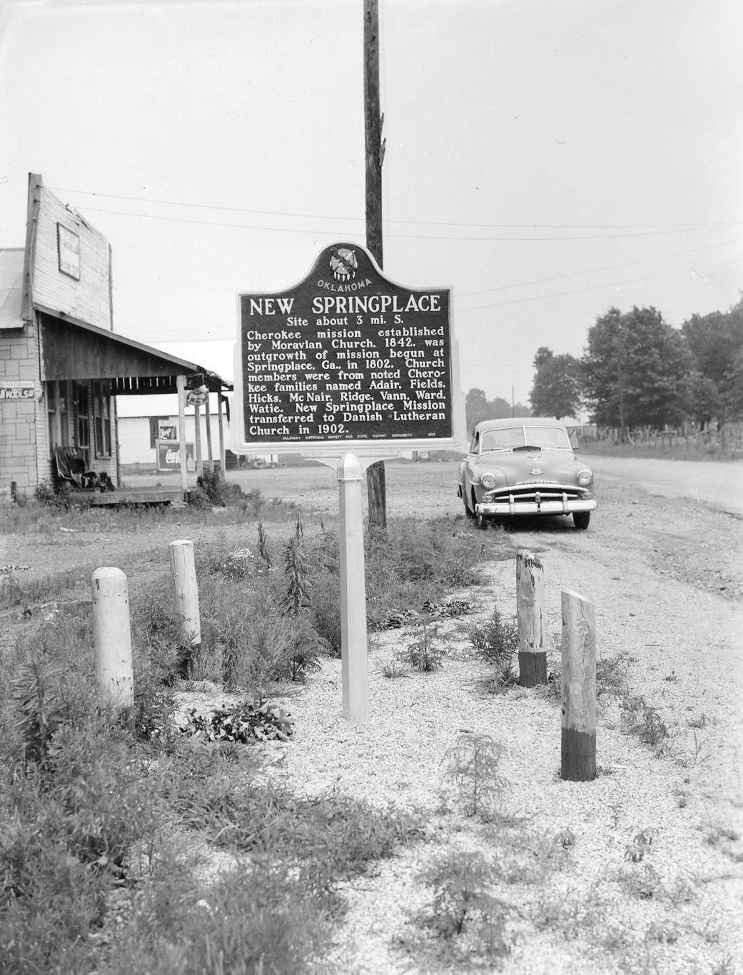
Location: on OK-412A, three miles north of Oaks
Material: Aluminum
Topics: Westward Expansion 1803–1861, Religion/Philosophy, Social/Cultural, American Indians
Established by the Moravian Church in 1842, the old mission was closed during the Civil War after missionary James Ward was ambushed and killed. Prominent Cherokee families such as Adair, Fields, Ridge, Vann, and Watie attended the mission.
Location: in Polson Cemetery, two miles northwest of South West City, Missouri
Material: Granite
Topics: American Indians, Military, Government, Territorial Period 1861–1907
Stand Watie, a leader of the pro-removal faction of Cherokees in the southeastern United States, was the first Indian commissioned in the Civil War as a general officer. At the close of the conflict, he commanded all Confederate troops in the Department of Indian Territory. In May of 1865, he surrendered to Union troops near Fort Towson, the last Confederate general to lay down his arms.
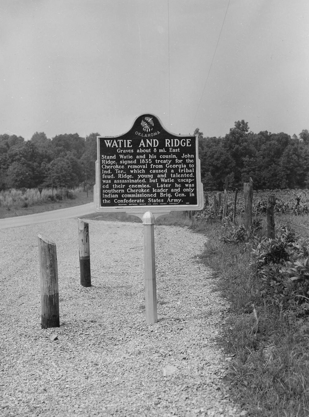
Location: on US-59, 1/2 mile south of Grove
Material: Aluminum
Topics: American Indians, Settlement Patterns, Government, Military
Watie and his cousin, John Ridge, were signers of the 1835 treaty that brought about the removal of the Cherokees from Georgia to Indian Territory. Ridge was killed by opponents of removal, but Watie escaped and became a general in the Confederate Army during the Civil War. See Stand Watie.
Le Flore County
Lincoln County
Logan County
Love County
Marshall County
Mayes County
McClain County
McCurtain County
McIntosh County
Murray County
Muskogee County
Noble County
Okfuskee County
Oklahoma County
Okmulgee County
Osage County
Ottawa County
Pawnee County
Payne County
Pittsburg County
Pontotoc County
Pottawatomie County
Pushmataha County
Roger Mills County
Rogers County
Seminole County
Sequoyah County
Stephens County
Texas County
Tillman County
Tulsa County
Wagoner County
Washington County
Washita County
Woods County
Woodward County
Historical Marker Program
Search Results
Your search returned 7 results.
Cherokee-Seneca Boundary
Delaware CountyLocation: on US-59 at Buffalo Creek
Material: Aluminum
Topics: American Indians, Settlement Patterns, Government
In 1831, more than 400 members of the Seneca Tribe in Ohio gave up their reservation land in exchange for a tract of land in the northeastern part of the Cherokee Nation. This was the boundary between the Cherokee land and the Seneca territory that comprised an area of 67,000 acres, seven miles by fifteen miles.
Fort Wayne
Delaware CountyLocation: on SH20, about one mile west of Arkansas line
Material: Aluminum
Topics: Military, Settlement Patterns, Westward Expansion 1803–1861, American Indians
Fort Wayne was originally intended as a link in the great line of forts extending north and south to afford protection on the frontier of the unknown West. It was soon realized that such extensive precautions were not necessary, and the locations were abandoned. One building had been completed, with four more under construction. These improvements were given to the Cherokee Nation and were in use until after the War Between the States. The exact site is known, but the buildings no longer exist and today nothing remains to mark the location of this frontier army post.
Moravian Mission Cemetery
Cherokee / Delaware CountyLocation: New Springplace Mission near Oaks
Moravian Mission Cemetery
Delaware CountyLocation: at New Springplace Mission near Oaks
Topics: American Indians, Westward Expansion 1803–1861, Religion/Philosophy, Territorial Period 1861–1907
Established as a Cherokee mission in 1842 by the Moravian Church, the institution was an outgrowth of a similar mission in Georgia, which was begun in 1802. Closed during the Civil War, the mission reopened afterward and continued to operate until 1902, when it was transferred to the Danish Lutheran Church. Only the walled spring and the gravestones of the cemetery, where many of the early missionaries were buried, remain.
New Springplace Cherokee Mission
Delaware CountyLocation: on OK-412A, three miles north of Oaks
Material: Aluminum
Topics: Westward Expansion 1803–1861, Religion/Philosophy, Social/Cultural, American Indians
Established by the Moravian Church in 1842, the old mission was closed during the Civil War after missionary James Ward was ambushed and killed. Prominent Cherokee families such as Adair, Fields, Ridge, Vann, and Watie attended the mission.
Stand Watie
Delaware CountyLocation: in Polson Cemetery, two miles northwest of South West City, Missouri
Material: Granite
Topics: American Indians, Military, Government, Territorial Period 1861–1907
Stand Watie, a leader of the pro-removal faction of Cherokees in the southeastern United States, was the first Indian commissioned in the Civil War as a general officer. At the close of the conflict, he commanded all Confederate troops in the Department of Indian Territory. In May of 1865, he surrendered to Union troops near Fort Towson, the last Confederate general to lay down his arms.
Watie and Ridge
Delaware CountyLocation: on US-59, 1/2 mile south of Grove
Material: Aluminum
Topics: American Indians, Settlement Patterns, Government, Military
Watie and his cousin, John Ridge, were signers of the 1835 treaty that brought about the removal of the Cherokees from Georgia to Indian Territory. Ridge was killed by opponents of removal, but Watie escaped and became a general in the Confederate Army during the Civil War. See Stand Watie.
(Page 1 of 1)
Search for Markers
Search by keyword or browse by county to learn about more than 600 historical markers created to recognize key locations, events, and people in Oklahoma history.
Please note that some markers listed in this database may have been moved, damaged, or are no longer standing.
Browse by County
Adair County
Alfalfa County
Atoka County
Beaver County
Beckham County
Blaine County
Bryan County
Caddo County
Canadian County
Carter County
Cherokee County
Choctaw County
Cimarron County
Cleveland County
Comanche County
Cotton County
Craig County
Creek County
Custer County
Delaware County
Dewey County
Ellis County
Garfield County
Garvin County
Grady County
Grant County
Greer County
Harmon County
Harper County
Haskell County
Hughes County
Jackson County
Jefferson County
Johnston County
Kay County
Kingfisher County
Kiowa County
Latimer CountyAlfalfa County
Atoka County
Beaver County
Beckham County
Blaine County
Bryan County
Caddo County
Canadian County
Carter County
Cherokee County
Choctaw County
Cimarron County
Cleveland County
Comanche County
Cotton County
Craig County
Creek County
Custer County
Delaware County
Dewey County
Ellis County
Garfield County
Garvin County
Grady County
Grant County
Greer County
Harmon County
Harper County
Haskell County
Hughes County
Jackson County
Jefferson County
Johnston County
Kay County
Kingfisher County
Kiowa County
Le Flore County
Lincoln County
Logan County
Love County
Marshall County
Mayes County
McClain County
McCurtain County
McIntosh County
Murray County
Muskogee County
Noble County
Okfuskee County
Oklahoma County
Okmulgee County
Osage County
Ottawa County
Pawnee County
Payne County
Pittsburg County
Pontotoc County
Pottawatomie County
Pushmataha County
Roger Mills County
Rogers County
Seminole County
Sequoyah County
Stephens County
Texas County
Tillman County
Tulsa County
Wagoner County
Washington County
Washita County
Woods County
Woodward County
Contact Us
If you have questions, please contact:
Matthew Pearce
Oklahoma Historical Society
800 Nazih Zuhdi Drive
Oklahoma City, OK 73105
405-522-8659
matthew.pearce@history.ok.gov