
Home | About OHS | Historical Marker Program
Location: at intersection of 13th Street and South Avenue in Ponca City (DAR)
Sponsored by: Daughters of the American Revolution
Topics: Water, Westward Expansion 1803–1861, Territorial Period 1861–1907, Urban Development
Indians and explorers used this water supply before it became the main water supply for Ponca City, a village established after the opening of the Cherokee Outlet in 1892.
Location: Pioneer Woman Museum
Material: Granite
Topics: Petroleum, Government, Early Statehood 1907–1941, Natural Resources, Environmental/Cultural Ecology
Original plans for creating Interstate Compact to conserve oil and gas were developed on December 4, 1934, at the home of Governor-elect E.W. Marland, located one half mile northeast of this spot. Participants from twelve oil-producing states took part in these discussions of national and international significance. The purpose was to form a compact for bringing about conservation and prevention of waste in petroleum resources, through coordinated efforts of States Compact, creating the Interstate Oil Compact Commission. It was approved on February 16, 1935, in Dallas, Texas, and was ratified the same year by the legislatures of Oklahoma, Texas, New Mexico, Colorado, Illinois, Kansas, and consented to by Congress on August 27, 1935. By 1966, thirty states were active members, and three were associate members. Official observers included representatives from Alberta and Saskatchewan in Canada; Colombia and Venezuela in South America; US Department of Defense and Interior; and the Federal Power Commission. The headquarters of the Compact Commission were established on Capitol grounds in Oklahoma City.
Location: at intersection of Fourth Street and Grand Avenue in Ponca City (DAR)
Sponsored by: Daughters of the American Revolution
Topics: Water, Early Statehood 1907–1941, Social/Cultural
The first watering fountain in Ponca City once stood near the Marland Estate stables. Mrs. George Fluke, the designer of the Oklahoma state flag, repainted the relief daises on the fountain.
Location: at Top of Oklahoma Historical Museum, 303 South Main Street, Blackwell
Topics: Social/Cultural, Land Openings, Mining, Territorial Period 1861–1907
Markers honor the centennial of Blackwell in 1993, the homesteaders who made the run into the Cherokee Outlet in 1893, and employees of Blackwell Zinc Company who served in World War II.
Location: original entrance into the camp, which is north of Tonkawa between Public and Main Streets
Topics: Military, Social/Cultural, Government, Ethnic Diversity, Agriculture, Industrial Period 1841–1892
Between October and December of 1942 more than nine hundred construction workers labored twenty-four hours a day to build Camp Tonkawa on the quarter section immediately north of this marker (SE1/2 Sec. 28-26N-1W). The 160-acre site contained more than 180 wooden structures for 3,000 German prisoners of war (POWs), as well as five hundred US Army guard troops, service personnel, and civilian employees. Activated in January 1943, the post received its first POWs in August: German troops of the Afrika Corps captured in North Africa. The facility operated at or near capacity throughout its existence. Prisoners worked on area farms and ranches as well as at an alfalfa dryer plant in Tonkawa. In November 1943, a disturbance among the prisoners resulted in the death of one German soldier. Eight POWs escaped from the camp but all were recaptured. Camp Tonkawa closed in September 1945, and the POWs were returned to Europe.
Location: on US-77 at Oklahoma-Kansas border (DAR)
Sponsored by: Daughters of the American Revolution
Topics: Land Openings, Territorial Period 1861–1907, Settlement Patterns
The east-west line marks the northern border of the Cherokee Outlet, opened for settlement on September 16, 1893.
Location: east of junction of US-177 and US-60, south of Ponca City
Material: Granite
Topics: American Indians, Settlement Patterns
The Nez Perce Indians were removed to this area from their native lands in Idaho (1878–1884).
Location: on US-77, three miles south of the Kansas border
Material: Granite
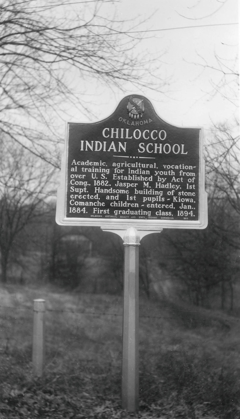
Topics: Education, American Indians, Territorial Period 1861–1907, Industrial Period 1841–1892, Ethnic Diversity
Congress authorized this school for Indian children in 1882. Before its closing in the 1970s, Chilocco was one of the largest Indian schools in the United States. On part of the original 9,000 acres set aside for the school, a major archaeological find proved the existence of Ferdinandina, a French trading post established around 1746 and considered to be the first white settlement in what would become Oklahoma.
Location: on US-77 south of Salt Fork of the Arkansas River
Topics: Recreational/Service, Ranching, Industry/Business
Zack Miller of the famous 101 Ranch gave this property to the Cherokee Strip Cowpunchers Association in 1930 to use as a location for annual reunions of "those who had ridden the range" in the Cherokee Strip. The site was later given to the Oklahoma Historical Society to maintain the graves of Miller and trick-shop performer Jack Webb.
Location: on grounds of Marland Estate, 901 Monument Road, Ponca City
Topics: Government, Petroleum, Natural Resources, Environmental/Cultural Ecology, Early Statehood 1907–1941
Governor Ernest W. Marland helped found the compact in 1935 among the oil and gas producing states. The compact was the beginning of efforts to conserve the nation's oil and gas reserves.
Location: at entrance to Kaw City Museum, 910 Washunga Drive, Kaw City
Topics: Government, Natural Resources, Environmental/Cultural Ecology, Territorial Period 1861–1907, Industrial Period 1841–1892, Urban Development, Land Openings, Petroleum, Social/Cultural, Natural Resources
The "old" town of Kaw City was covered by the waters of Kaw Lake in the 1970s and the new town rebuilt on higher ground nearby. The only commercial building moved was the 1902 train depot which became the home of the Kaw City Museum. Kaw City native Kenneth Brill made a fortune in the oil and gas business and contributed much to preserve Kaw City history.
Location: at 1000 East Grand Avenue, Ponca City (DAR)
Sponsored by: Daughters of the American Revolution
Topics: Family/Household, Early Statehood 1907–1941, Natural Resources, Industry/Business, Government
Plaques at the flagpole and on a bird bath recall the grandeur of the first home built by oilman E. W. Marland in 1916. Before he was elected governor of Oklahoma, Marland founded what became Conoco and at one time controlled 10 percent of the nation's oil production.
Location: in downtown pocket parks in Newkirk
Topics: Land Openings, Settlement Patterns, Petroleum, Urban Development, Ethnic Diversity, Recreational/Service
Enameled historical markers with photographs commemorate the Cherokee Outlet, Cherokee allotments, the Oil Boom, the Fire of 1901, Newkirk Country Club, Kay County Fair, Newkirk African-Americans, and the history of Newkirk.
Location: on grounds of Top of Oklahoma Historical Museum, 303 South Main Street, Blackwell
Topics: Education, Religion/Philosophy, Territorial Period 1861–1907, Early Statehood 1907–1941
The Oklahoma Baptist College was founded in 1899 by the Oklahoma Baptist Convention. The school opened in 1901 and closed in 1913. Top enrollment was 208 in 1911.
Location: in downtown Blackwell (OBHC)
Topics: Education, Religion/Philosophy
The college was a forerunner of Oklahoma Baptist University in Shawnee.
Location: on US-77 just south of Kansas line, Kay County
Material: Aluminum
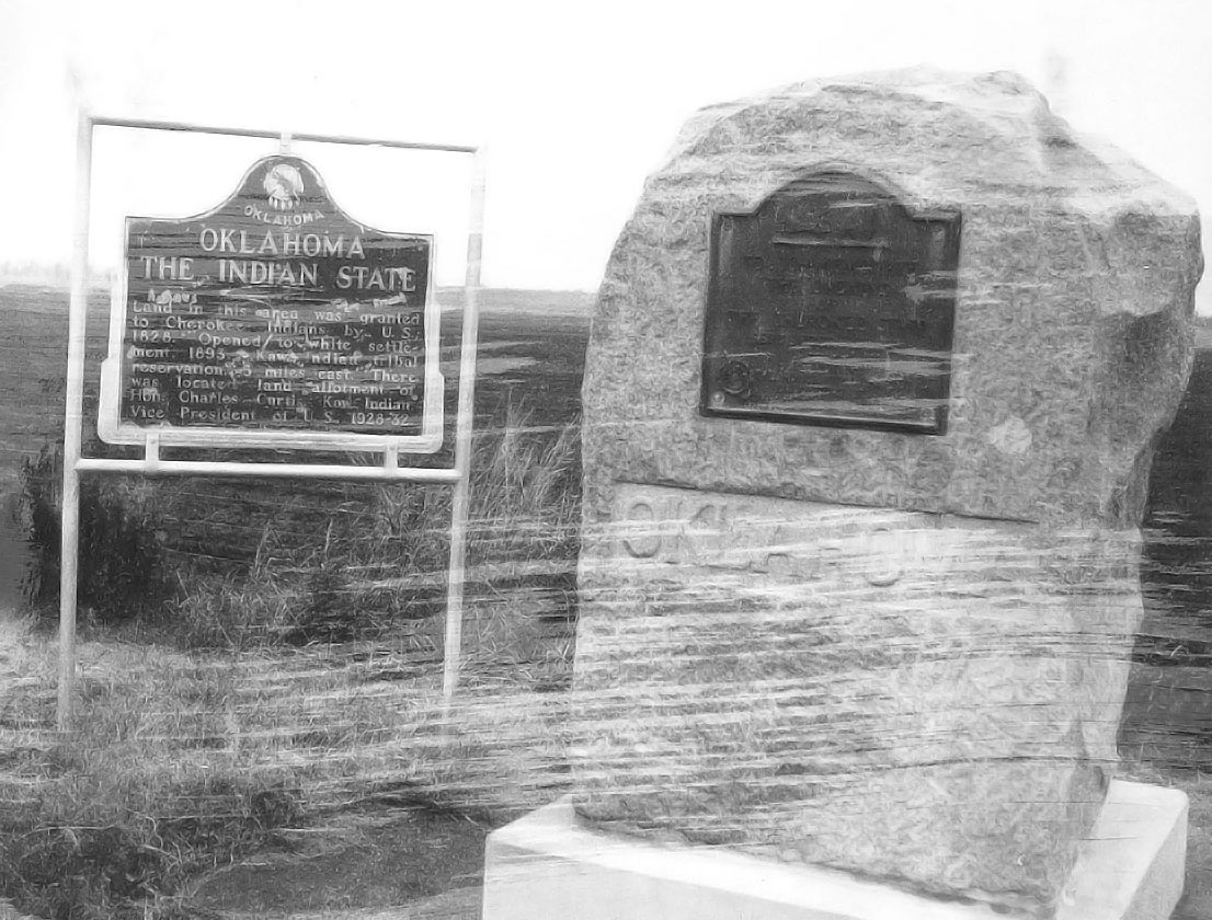
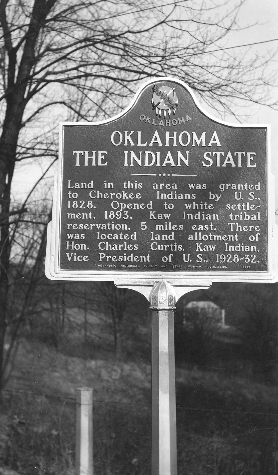
Topics: Settlement Patterns, American Indians, Government, Land Openings, Westward Expansion 1803–1861, Territorial Period 1861–1907
Land in this area was granted to Cherokee Indians by the US in 1828. It opened to white settlement in 1893. The Kaw Indian Tribal Reservation is located five miles east. There was located the land allotment of the Honorable Charles Curtis, Kaw Indian, Vice President of the United States, 1928–32.
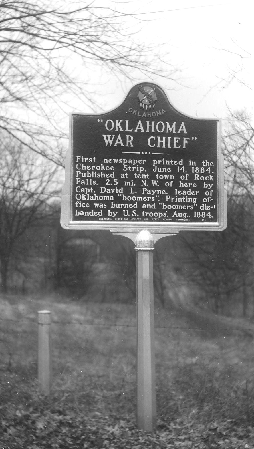
Location: on US-177 west of Braman
Topics: Settlement Patterns, Land Openings, Mass Communication, Military, Territorial Period 1861–1907
Captain David L. Payne published the first newspaper in the Cherokee Outlet, the Oklahoma War Chief, on June 14, 1884, in a printing plant in a tent in this area. The printing office was burned by federal troops two months later.
Location: on North Fifth Street in Ponca City
Topics: Petroleum, Natural Resources, Industry/Business
Pioneer Park's gate honors pioneer oil and gas prospector C.H. Ruby. The city's first gas supply came from wells located on the present site of North Park.
Location: on the grounds of the Pioneer Woman Museum in Ponca City
Location: 1501-1509 Summers Place, Ponca City, OK
Material: Aluminum
Topics: Military, Education, Industry/Business
Ponca Military Academy was established in 1940 by the late Colonel William V. Cox and his wife Blanche. PMA made a vibrant contribution to the Ponca City community and to the state of Oklahoma. Dedicated to the growth and advancement of young men, Ponca Military Academy opened their doors to not only young men from Oklahoma, but throughout the country. Originally located on 56 acres of land, the academy occupied what was a former training facility and country club for E.W. Marland's oil company which became the Continental Oil Company (Conoco). An administration building, barracks, gym, parade grounds, athletic fields, tennis courts, and a playground encompassed the academy. They were located one-half mile south of this location at the end of Academy Road and along Cadet Road. At its height PMA had 150 student cadets and 14 faculty. After 34 years of operation the decision was made to close the academy in 1974. Approximately 4,000 young men attended PMA through its 34 years.
Location: in IOOF Cemetery on South Waverly Avenue in Ponca City
Topics: Military, Social/Cultural, Transportation, Urban Development, Settlement Patterns, Territorial Period 1861–1907, Industrial Period 1892–1941
England's Royal Air Force fliers trained in Ponca City as they prepared to defend the United Kingdom in World War II. The cemetery also contains a flagpole dedicated to Jack Barrington, an Englishman who trained in Ponca City, married a local girl, and returned to live out his life there. There is also a large memorial in the cemetery that honors men and women who served in the armed forces.
Le Flore County
Lincoln County
Logan County
Love County
Marshall County
Mayes County
McClain County
McCurtain County
McIntosh County
Murray County
Muskogee County
Noble County
Okfuskee County
Oklahoma County
Okmulgee County
Osage County
Ottawa County
Pawnee County
Payne County
Pittsburg County
Pontotoc County
Pottawatomie County
Pushmataha County
Roger Mills County
Rogers County
Seminole County
Sequoyah County
Stephens County
Texas County
Tillman County
Tulsa County
Wagoner County
Washington County
Washita County
Woods County
Woodward County
Historical Marker Program
Search Results
Your search returned 21 results.
Big Spring
Kay CountyLocation: at intersection of 13th Street and South Avenue in Ponca City (DAR)
Sponsored by: Daughters of the American Revolution
Topics: Water, Westward Expansion 1803–1861, Territorial Period 1861–1907, Urban Development
Indians and explorers used this water supply before it became the main water supply for Ponca City, a village established after the opening of the Cherokee Outlet in 1892.
Birthplace of Interstate Oil Compact Commission
Kay CountyLocation: Pioneer Woman Museum
Material: Granite
Topics: Petroleum, Government, Early Statehood 1907–1941, Natural Resources, Environmental/Cultural Ecology
Original plans for creating Interstate Compact to conserve oil and gas were developed on December 4, 1934, at the home of Governor-elect E.W. Marland, located one half mile northeast of this spot. Participants from twelve oil-producing states took part in these discussions of national and international significance. The purpose was to form a compact for bringing about conservation and prevention of waste in petroleum resources, through coordinated efforts of States Compact, creating the Interstate Oil Compact Commission. It was approved on February 16, 1935, in Dallas, Texas, and was ratified the same year by the legislatures of Oklahoma, Texas, New Mexico, Colorado, Illinois, Kansas, and consented to by Congress on August 27, 1935. By 1966, thirty states were active members, and three were associate members. Official observers included representatives from Alberta and Saskatchewan in Canada; Colombia and Venezuela in South America; US Department of Defense and Interior; and the Federal Power Commission. The headquarters of the Compact Commission were established on Capitol grounds in Oklahoma City.
Black Iron Fountain
Kay CountyLocation: at intersection of Fourth Street and Grand Avenue in Ponca City (DAR)
Sponsored by: Daughters of the American Revolution
Topics: Water, Early Statehood 1907–1941, Social/Cultural
The first watering fountain in Ponca City once stood near the Marland Estate stables. Mrs. George Fluke, the designer of the Oklahoma state flag, repainted the relief daises on the fountain.
Blackwell Museum
Kay CountyLocation: at Top of Oklahoma Historical Museum, 303 South Main Street, Blackwell
Topics: Social/Cultural, Land Openings, Mining, Territorial Period 1861–1907
Markers honor the centennial of Blackwell in 1993, the homesteaders who made the run into the Cherokee Outlet in 1893, and employees of Blackwell Zinc Company who served in World War II.
Camp Tonkawa Prisoner of War Camp
Kay CountyLocation: original entrance into the camp, which is north of Tonkawa between Public and Main Streets
Topics: Military, Social/Cultural, Government, Ethnic Diversity, Agriculture, Industrial Period 1841–1892
Between October and December of 1942 more than nine hundred construction workers labored twenty-four hours a day to build Camp Tonkawa on the quarter section immediately north of this marker (SE1/2 Sec. 28-26N-1W). The 160-acre site contained more than 180 wooden structures for 3,000 German prisoners of war (POWs), as well as five hundred US Army guard troops, service personnel, and civilian employees. Activated in January 1943, the post received its first POWs in August: German troops of the Afrika Corps captured in North Africa. The facility operated at or near capacity throughout its existence. Prisoners worked on area farms and ranches as well as at an alfalfa dryer plant in Tonkawa. In November 1943, a disturbance among the prisoners resulted in the death of one German soldier. Eight POWs escaped from the camp but all were recaptured. Camp Tonkawa closed in September 1945, and the POWs were returned to Europe.
Cherokee Strip Opening
Kay CountyLocation: on US-77 at Oklahoma-Kansas border (DAR)
Sponsored by: Daughters of the American Revolution
Topics: Land Openings, Territorial Period 1861–1907, Settlement Patterns
The east-west line marks the northern border of the Cherokee Outlet, opened for settlement on September 16, 1893.
Chief Joseph
Kay CountyLocation: east of junction of US-177 and US-60, south of Ponca City
Material: Granite
Topics: American Indians, Settlement Patterns
The Nez Perce Indians were removed to this area from their native lands in Idaho (1878–1884).
Chilocco Indian School
Kay CountyLocation: on US-77, three miles south of the Kansas border
Material: Granite
Topics: Education, American Indians, Territorial Period 1861–1907, Industrial Period 1841–1892, Ethnic Diversity
Congress authorized this school for Indian children in 1882. Before its closing in the 1970s, Chilocco was one of the largest Indian schools in the United States. On part of the original 9,000 acres set aside for the school, a major archaeological find proved the existence of Ferdinandina, a French trading post established around 1746 and considered to be the first white settlement in what would become Oklahoma.
Cowboy Hill
Kay CountyLocation: on US-77 south of Salt Fork of the Arkansas River
Topics: Recreational/Service, Ranching, Industry/Business
Zack Miller of the famous 101 Ranch gave this property to the Cherokee Strip Cowpunchers Association in 1930 to use as a location for annual reunions of "those who had ridden the range" in the Cherokee Strip. The site was later given to the Oklahoma Historical Society to maintain the graves of Miller and trick-shop performer Jack Webb.
Interstate Oil Compact Commission
Kay CountyLocation: on grounds of Marland Estate, 901 Monument Road, Ponca City
Topics: Government, Petroleum, Natural Resources, Environmental/Cultural Ecology, Early Statehood 1907–1941
Governor Ernest W. Marland helped found the compact in 1935 among the oil and gas producing states. The compact was the beginning of efforts to conserve the nation's oil and gas reserves.
Kenneth Brill
Kay CountyLocation: at entrance to Kaw City Museum, 910 Washunga Drive, Kaw City
Topics: Government, Natural Resources, Environmental/Cultural Ecology, Territorial Period 1861–1907, Industrial Period 1841–1892, Urban Development, Land Openings, Petroleum, Social/Cultural, Natural Resources
The "old" town of Kaw City was covered by the waters of Kaw Lake in the 1970s and the new town rebuilt on higher ground nearby. The only commercial building moved was the 1902 train depot which became the home of the Kaw City Museum. Kaw City native Kenneth Brill made a fortune in the oil and gas business and contributed much to preserve Kaw City history.
Marland's Grand Home
Kay CountyLocation: at 1000 East Grand Avenue, Ponca City (DAR)
Sponsored by: Daughters of the American Revolution
Topics: Family/Household, Early Statehood 1907–1941, Natural Resources, Industry/Business, Government
Plaques at the flagpole and on a bird bath recall the grandeur of the first home built by oilman E. W. Marland in 1916. Before he was elected governor of Oklahoma, Marland founded what became Conoco and at one time controlled 10 percent of the nation's oil production.
Newkirk
Kay CountyLocation: in downtown pocket parks in Newkirk
Topics: Land Openings, Settlement Patterns, Petroleum, Urban Development, Ethnic Diversity, Recreational/Service
Enameled historical markers with photographs commemorate the Cherokee Outlet, Cherokee allotments, the Oil Boom, the Fire of 1901, Newkirk Country Club, Kay County Fair, Newkirk African-Americans, and the history of Newkirk.
Oklahoma Baptist College
Kay CountyLocation: on grounds of Top of Oklahoma Historical Museum, 303 South Main Street, Blackwell
Topics: Education, Religion/Philosophy, Territorial Period 1861–1907, Early Statehood 1907–1941
The Oklahoma Baptist College was founded in 1899 by the Oklahoma Baptist Convention. The school opened in 1901 and closed in 1913. Top enrollment was 208 in 1911.
Oklahoma Baptist College
Kay CountyLocation: in downtown Blackwell (OBHC)
Topics: Education, Religion/Philosophy
The college was a forerunner of Oklahoma Baptist University in Shawnee.
Oklahoma the Indian State
Kay CountyLocation: on US-77 just south of Kansas line, Kay County
Material: Aluminum
Topics: Settlement Patterns, American Indians, Government, Land Openings, Westward Expansion 1803–1861, Territorial Period 1861–1907
Land in this area was granted to Cherokee Indians by the US in 1828. It opened to white settlement in 1893. The Kaw Indian Tribal Reservation is located five miles east. There was located the land allotment of the Honorable Charles Curtis, Kaw Indian, Vice President of the United States, 1928–32.
Oklahoma War Chief
Kay CountyLocation: on US-177 west of Braman
Topics: Settlement Patterns, Land Openings, Mass Communication, Military, Territorial Period 1861–1907
Captain David L. Payne published the first newspaper in the Cherokee Outlet, the Oklahoma War Chief, on June 14, 1884, in a printing plant in a tent in this area. The printing office was burned by federal troops two months later.
Pioneer Park
Kay CountyLocation: on North Fifth Street in Ponca City
Topics: Petroleum, Natural Resources, Industry/Business
Pioneer Park's gate honors pioneer oil and gas prospector C.H. Ruby. The city's first gas supply came from wells located on the present site of North Park.
Pioneer Woman
Kay CountyLocation: on the grounds of the Pioneer Woman Museum in Ponca City
Ponca City Military Academy
Kay CountyLocation: 1501-1509 Summers Place, Ponca City, OK
Material: Aluminum
Topics: Military, Education, Industry/Business
Ponca Military Academy was established in 1940 by the late Colonel William V. Cox and his wife Blanche. PMA made a vibrant contribution to the Ponca City community and to the state of Oklahoma. Dedicated to the growth and advancement of young men, Ponca Military Academy opened their doors to not only young men from Oklahoma, but throughout the country. Originally located on 56 acres of land, the academy occupied what was a former training facility and country club for E.W. Marland's oil company which became the Continental Oil Company (Conoco). An administration building, barracks, gym, parade grounds, athletic fields, tennis courts, and a playground encompassed the academy. They were located one-half mile south of this location at the end of Academy Road and along Cadet Road. At its height PMA had 150 student cadets and 14 faculty. After 34 years of operation the decision was made to close the academy in 1974. Approximately 4,000 young men attended PMA through its 34 years.
Royal Air Force
Kay CountyLocation: in IOOF Cemetery on South Waverly Avenue in Ponca City
Topics: Military, Social/Cultural, Transportation, Urban Development, Settlement Patterns, Territorial Period 1861–1907, Industrial Period 1892–1941
England's Royal Air Force fliers trained in Ponca City as they prepared to defend the United Kingdom in World War II. The cemetery also contains a flagpole dedicated to Jack Barrington, an Englishman who trained in Ponca City, married a local girl, and returned to live out his life there. There is also a large memorial in the cemetery that honors men and women who served in the armed forces.
(Page 1 of 1)
Search for Markers
Search by keyword or browse by county to learn about more than 600 historical markers created to recognize key locations, events, and people in Oklahoma history.
Please note that some markers listed in this database may have been moved, damaged, or are no longer standing.
Browse by County
Adair County
Alfalfa County
Atoka County
Beaver County
Beckham County
Blaine County
Bryan County
Caddo County
Canadian County
Carter County
Cherokee County
Choctaw County
Cimarron County
Cleveland County
Comanche County
Cotton County
Craig County
Creek County
Custer County
Delaware County
Dewey County
Ellis County
Garfield County
Garvin County
Grady County
Grant County
Greer County
Harmon County
Harper County
Haskell County
Hughes County
Jackson County
Jefferson County
Johnston County
Kay County
Kingfisher County
Kiowa County
Latimer CountyAlfalfa County
Atoka County
Beaver County
Beckham County
Blaine County
Bryan County
Caddo County
Canadian County
Carter County
Cherokee County
Choctaw County
Cimarron County
Cleveland County
Comanche County
Cotton County
Craig County
Creek County
Custer County
Delaware County
Dewey County
Ellis County
Garfield County
Garvin County
Grady County
Grant County
Greer County
Harmon County
Harper County
Haskell County
Hughes County
Jackson County
Jefferson County
Johnston County
Kay County
Kingfisher County
Kiowa County
Le Flore County
Lincoln County
Logan County
Love County
Marshall County
Mayes County
McClain County
McCurtain County
McIntosh County
Murray County
Muskogee County
Noble County
Okfuskee County
Oklahoma County
Okmulgee County
Osage County
Ottawa County
Pawnee County
Payne County
Pittsburg County
Pontotoc County
Pottawatomie County
Pushmataha County
Roger Mills County
Rogers County
Seminole County
Sequoyah County
Stephens County
Texas County
Tillman County
Tulsa County
Wagoner County
Washington County
Washita County
Woods County
Woodward County
Contact Us
If you have questions, please contact:
Matthew Pearce
Oklahoma Historical Society
800 Nazih Zuhdi Drive
Oklahoma City, OK 73105
405-522-8659
matthew.pearce@history.ok.gov