
Home | About OHS | Historical Marker Program
Location: the west side of US-81, four miles south of Hennessey
Coordinates: 36.0564576,-97.8995264
Material: Granite
Topics: Ranching, Territorial Period 1861–1907
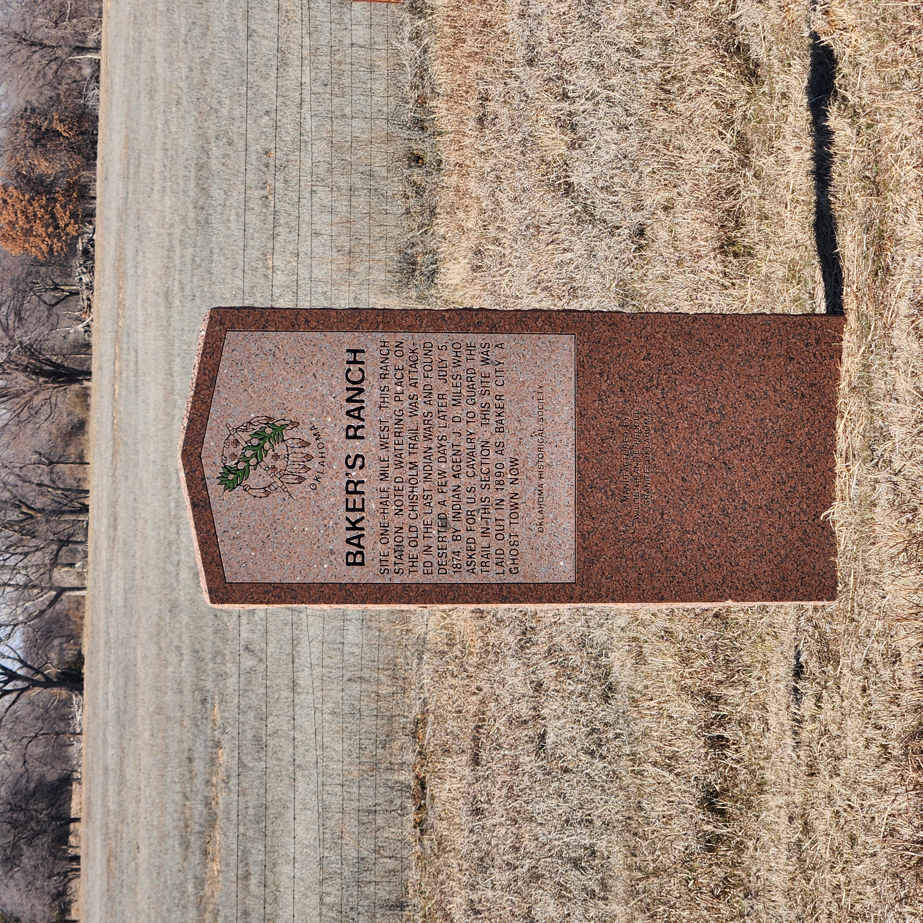
Site one-half mile west. This ranch station, noted water place on the old Chisholm Trail, was attacked in the last Indian Wars and found deserted a few days later, July 5, 1874, by Indian Agent J. D. Miles, who asked for U.S. Cavalry to guard the trail in this section. This site was laid out in 1890 as Baker City, a ghost town now.
Location: east of Kingfisher on State Hwy 33 on SE corner of SE 1/4 of 14-16-6
Coordinates: 35.856528, -97.798852
Material: Granite
Big Four School, located three miles north, was formed on March 17, 1920, by a special election vote to consolidate the districts of White Cap, Twilight, Wandell, and Bird Creek. The school graduated its first senior class in 1924; its last in 1968. It continued as a grade school until closing in May 1978.
Location: west of US-81 in Bull Foot Park, Hennessey
Coordinates: 36.1003327,-97.9004032
Material: Granite
Topics: Water, Ranching, Transportation, Folklife
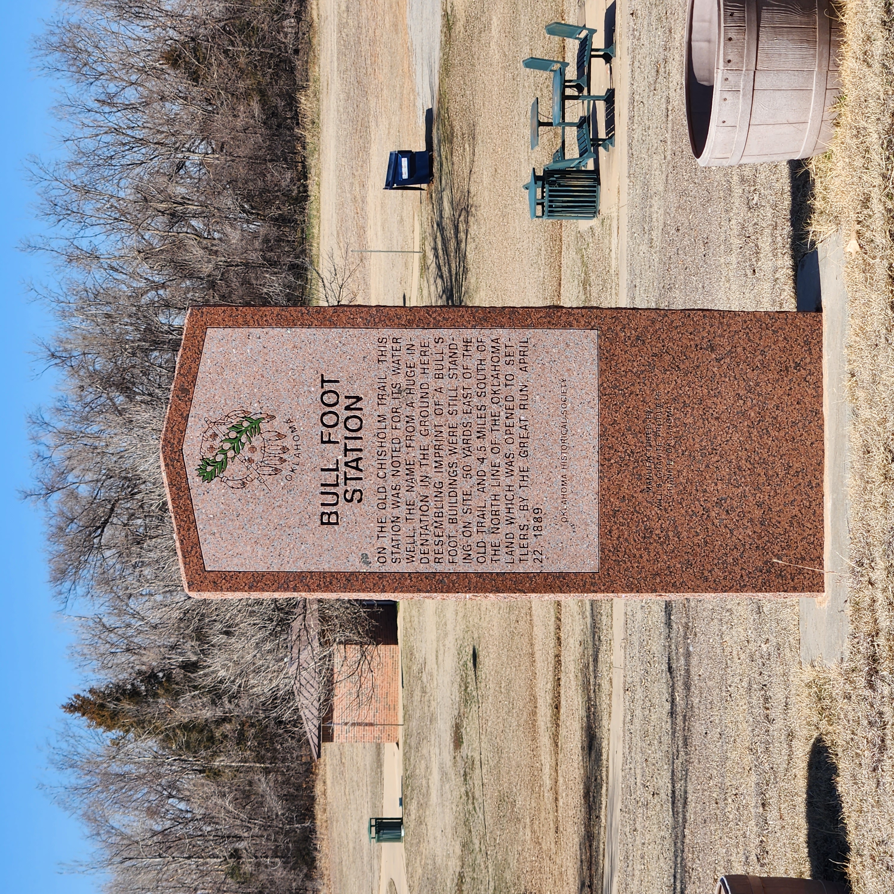
On the old Chisholm Trail, this station was noted for its water well. The name from a huge indentation in the ground here, resembling imprint of a bull's foot. Buildings were still standing on site, 50 yards east of the old trail, and 4.5 miles south of the north line of the Oklahoma land, which was opened to settlers by the great run, April 22, 1889.
Location: on US-81 at north edge of Dover
Material: Granite
Note: Marker may be missing
Topics: American Indians, Indian and Frontier Trade, Transportation, Ranching, Westward Expansion 1803–1861
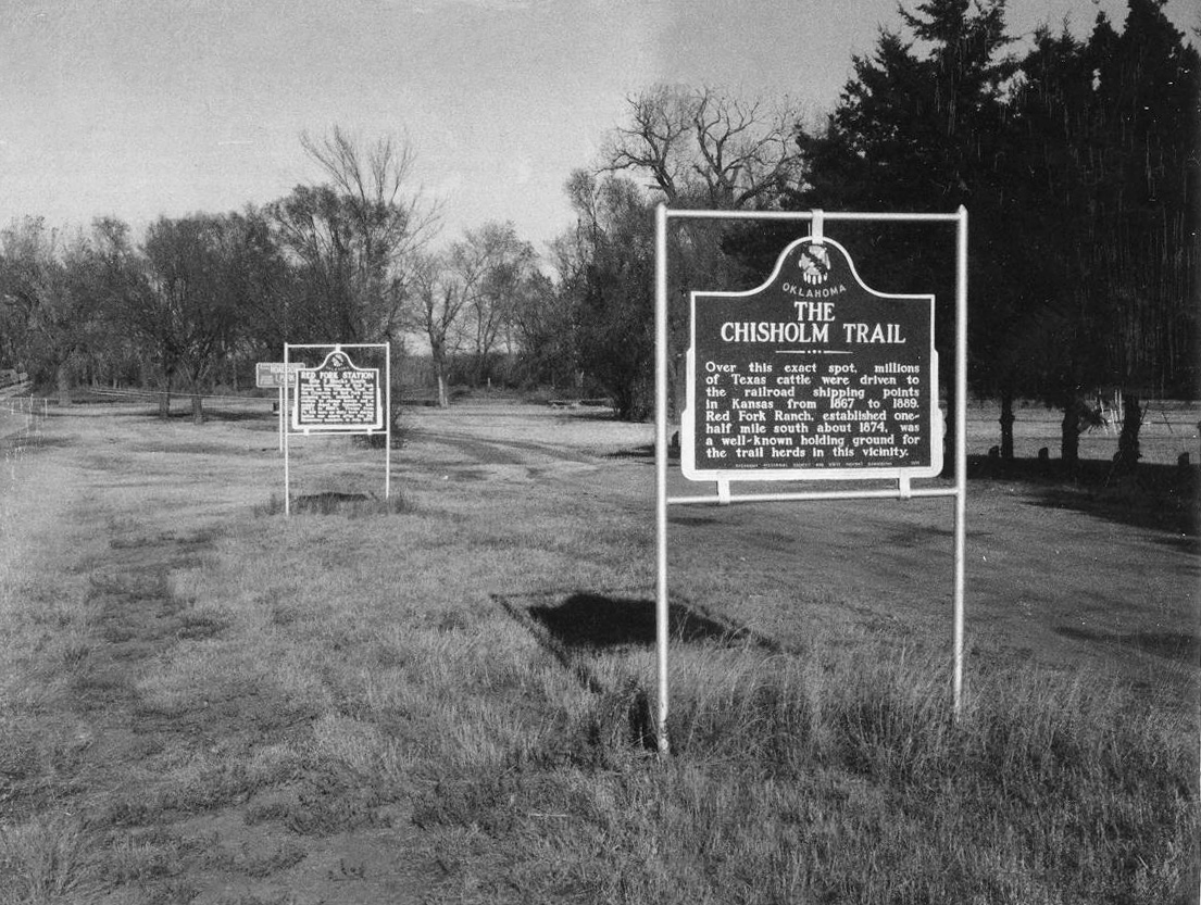
A pioneer merchant, trader, and explorer, Jesse Chisholm, a mix-blood Cherokee, established a trail through western Indian Territory before the Civil War. Texas cattlemen used the trail until the late 1880s to move millions of cattle to northern markets. The trail ran from Montague County, Texas, to Abilene, Kansas.
Location: on US-81 in Memorial Park in Hennessey
Coordinates: 36.1108233,-97.8993253
Material: Aluminum
Topics: Government, Mass Communication, Transportation, Territorial Period 1861–1907
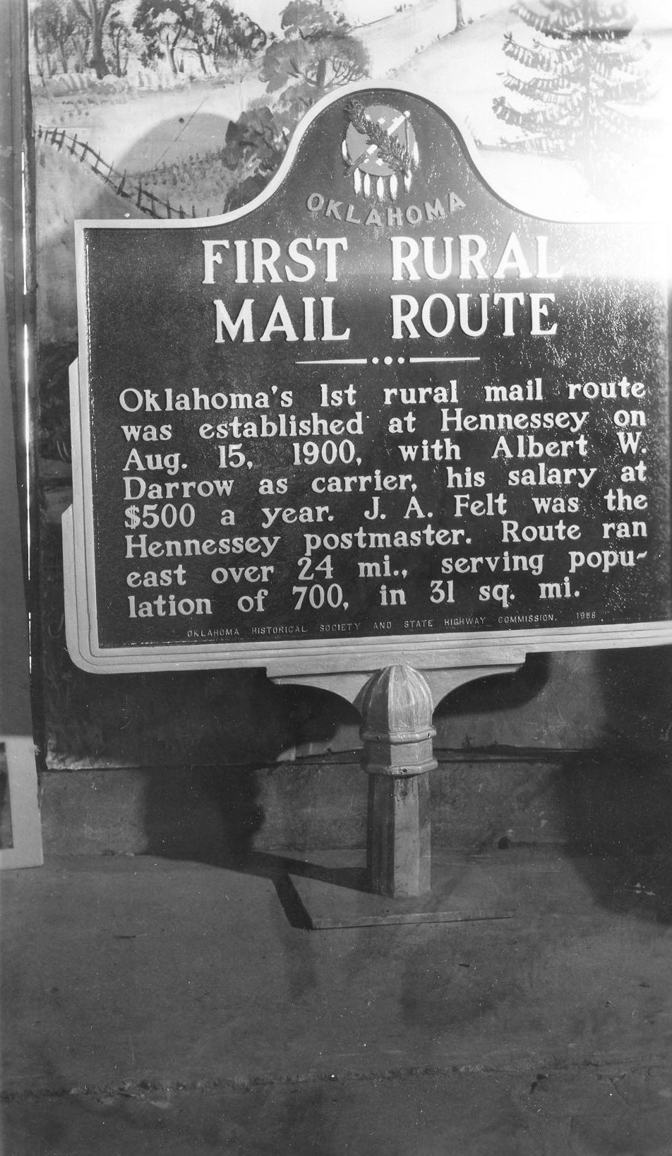
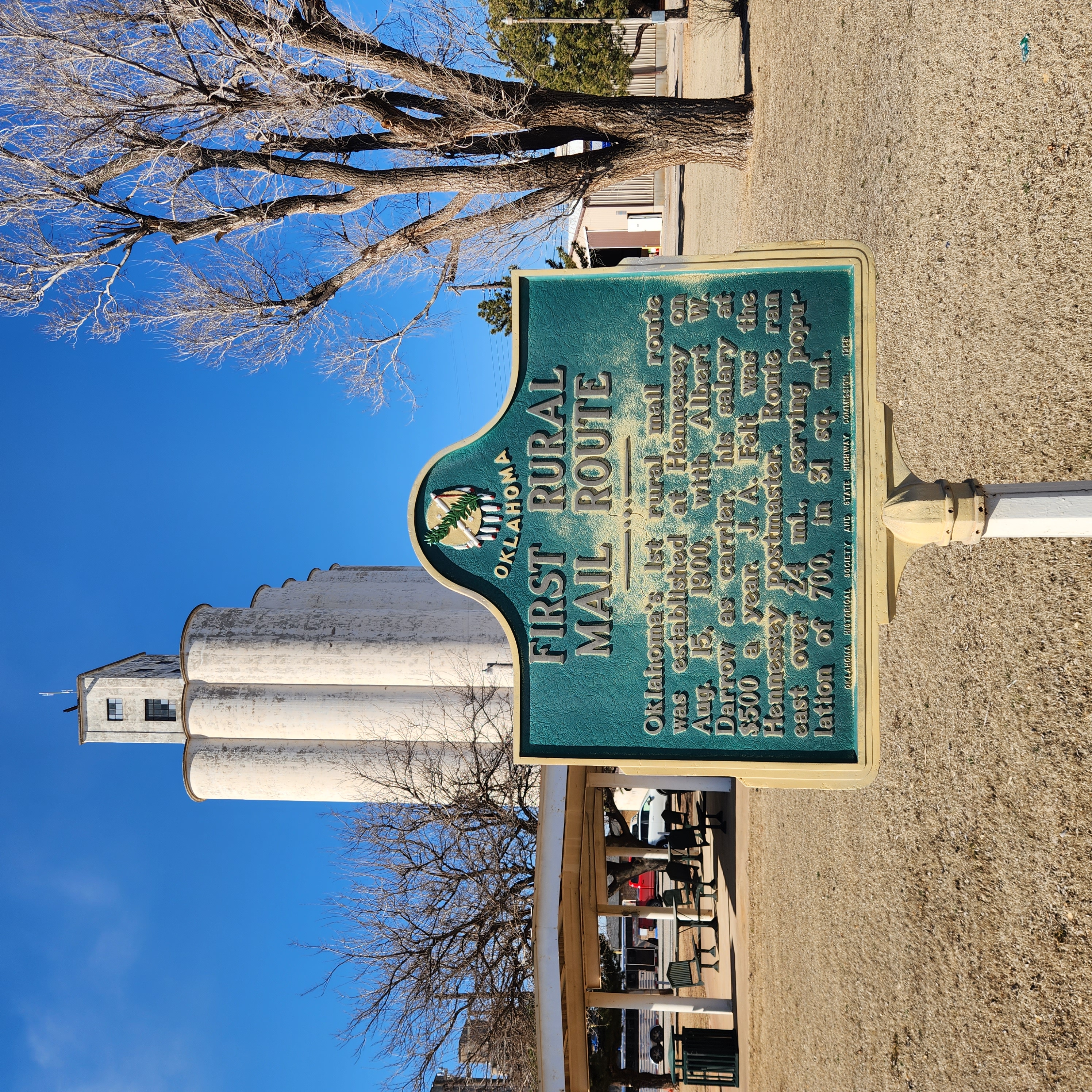
Oklahoma's 1st rural mail route was established at Hennessey on August 15, 1900, with Albert W. Darrow as carrier, his salary at $500 a year. J. A. Felt was the Hennessey postmaster. Route ran east over 24 miles, serving population of 700, in 31 square miles.
Location: on US-81, present grounds of the post office in Kingfisher
Coordinates: 35.8643008,-97.9328127
Material: Aluminum
Topics: Transportation, Social/Cultural, Territorial Period 1861–1907, Ranching, Land Openings
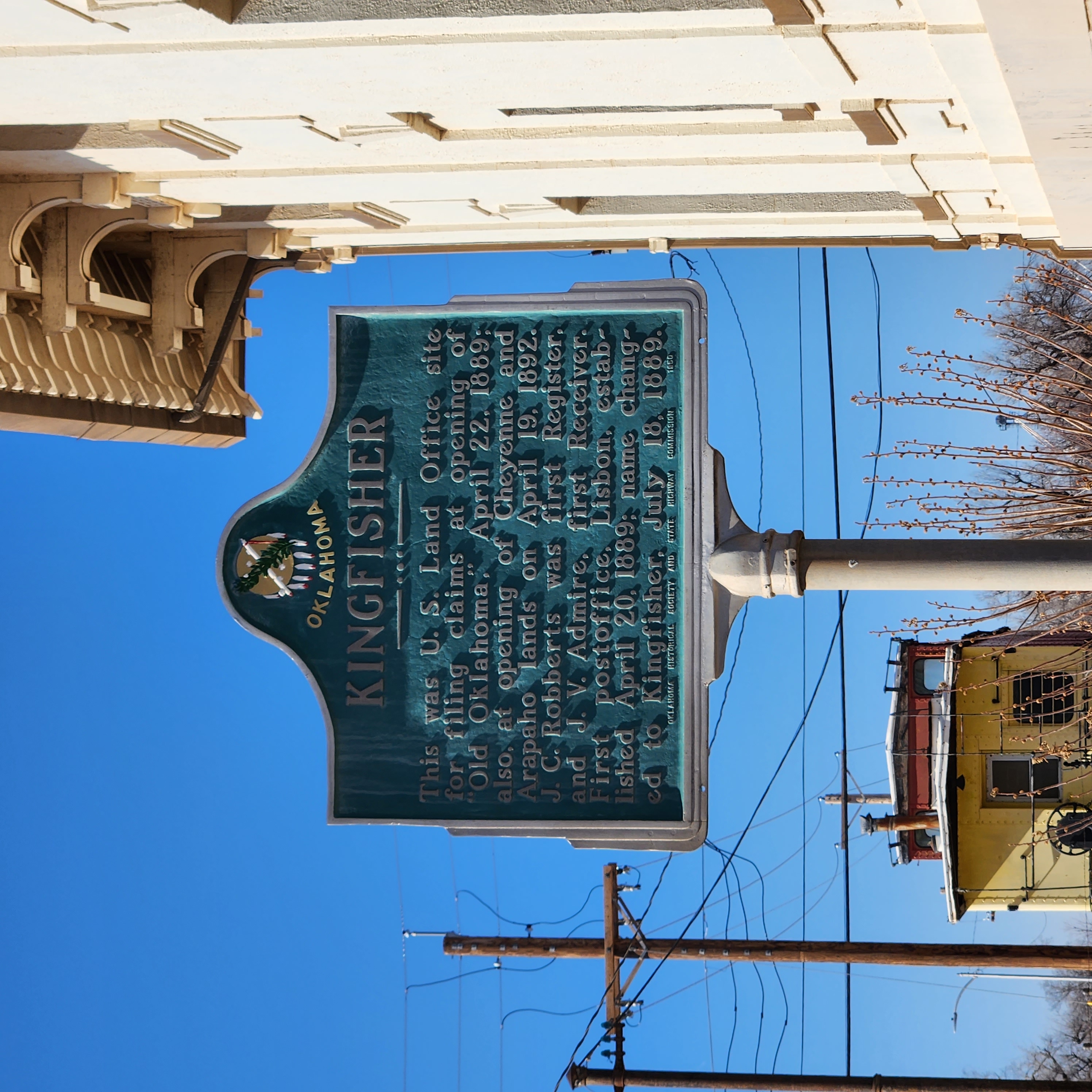
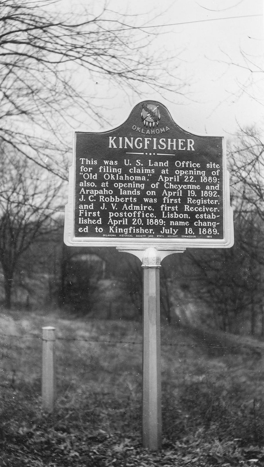
This was U.S. Land Office site for filing claims at opening of "Old Oklahoma," April 22, 1889; also, at opening of Cheyenne and Arapaho lands on April 19, 1892. J. C. Robberts was first Register and J. V. Admire, first Receiver. First post office, Lisbon, established April 20, 1899; name changed to Kingfisher, July 18, 1889.
Location: on OK-33 on east side of Kingfisher
Coordinates: 35.856833, -97.906900
Material: Aluminum
Topics: Education, Religion/Philosophy, Territorial Period 1861–1907, Early Statehood 1907–1941
The Congregationalists founded the Kingfisher College in 1890. When the school closed in 1922, its endowment was transferred to the University of Oklahoma to fund the Kingfisher Chair of Religion and Ethics.
Location: on OK-33, one mile west of Kingfisher
Coordinates: 35.860633, -97.941133
Material: Aluminum
Topics: Transportation, Ranching, Urban Development, Social/Cultural, Land Openings, Government, Settlement Patterns
This stage stop on the old Chisholm Trail from 1867 to 1889 and the town were named for King Fisher, owner of the station. See Chisholm Trail.
Location: on US-81 on grounds of Kingfisher post office
Material: Aluminum
Note: Marker may be missing
From a land office at this location, the federal government prescribed rules and regulations governing the opening of the Unassigned Lands in central Oklahoma on April 22, 1889. The office also registered claims for the April 19, 1892, opening of Cheyenne and Arapaho lands.
Location: on OK-51, ten miles west of Hennessey
Coordinates: 36.116037, -98.085605
Material: Granite
Topics: Government, Social/Cultural, Land Openings, Settlement Patterns
The town of Lacey was named for Congressman John F. Lacey of Iowa, chairman of the House Public Lands Committee, who crafted much of the legislation that allowed the opening of lands in Oklahoma to public settlement.
Location: on US-81 in Memorial Park in Hennessey
Coordinates: 36.111395, -97.899118
Material: Aluminum
Topics: Transportation, Indian and Frontier Trade, Territorial Period 1861–1907, American Indians
Freighter Pat Hennessey's charred body tied to his wagon wheel was found in a smoldering fire near 3 of his drivers, all killed on Jul 6, 1874, in last Indian wars when his train was on way along Chisholm Trail to Kiowa Agency. Grave is 2 blocks west.

Location: on grounds of county courthouse at Kingfisher
Coordinates: 35.860717, -97.932500
Material: Aluminum
Topics: Mass Communication, Social/Cultural, Territorial Period 1861–1907
The Oklahoma Press Association founded the Oklahoma Historical Society (OHS) at its convention in Kingfisher on May 27, 1893. The purpose of the new organization was to preserve files on all publications of Oklahoma and Indian territories and documents relating to the history of the region. The OHS headquarters remained in Kingfisher until 1895 when it was moved to Norman. The OHS moved to Oklahoma City in 1901.
Location: at Hwy-81 and Red Ford Drive, Dover
Sponsored by: Citizens and Friends of Dover, 1998
Material: Granite
Note: Marker may be missing
Topics: Indian and Frontier Trade, Ranching, Territorial Period 1861–1907, Land Openings, Agriculture, Urban Development
On this site once stood the trading post known as the Red Fork Ranch. The original ranch building was constructed in 1872 by the Lee and Reynolds Company. Over the following years, the ranch was operated by a number of different individuals, the last being John G. Chapin, who was operating the ranch when the Unassigned Lands were opened on April 22, 1889. Chapin formally claimed the homestead which included the townsite of Dover and which was platted by him in 1892. John Chapin could well be characterized as "the father of Dover".
Location: on US-81 in Dover
Coordinates: 35.9868352,-97.9087232
Material: Aluminum
Topics: Transportation, Indian and Frontier Trade, Ranching, Military, American Indians
The stage station and supply depot was an important shipping point for cattle moving up to the Chisholm Trail. Soldiers from Fort Sill fortified Red Fork during the Cheyenne and Arapaho uprising in 1874. The station was named for the first name of the Cimarron River-Red Fork of the Arkansas. See Chisholm Trail.
Location: on US-81 in Memorial Park in Hennessey
Coordinates: 36.111145, -97.899130
Material: Aluminum
Topics: Social/Cultural, Territorial Period 1861–1907, Military
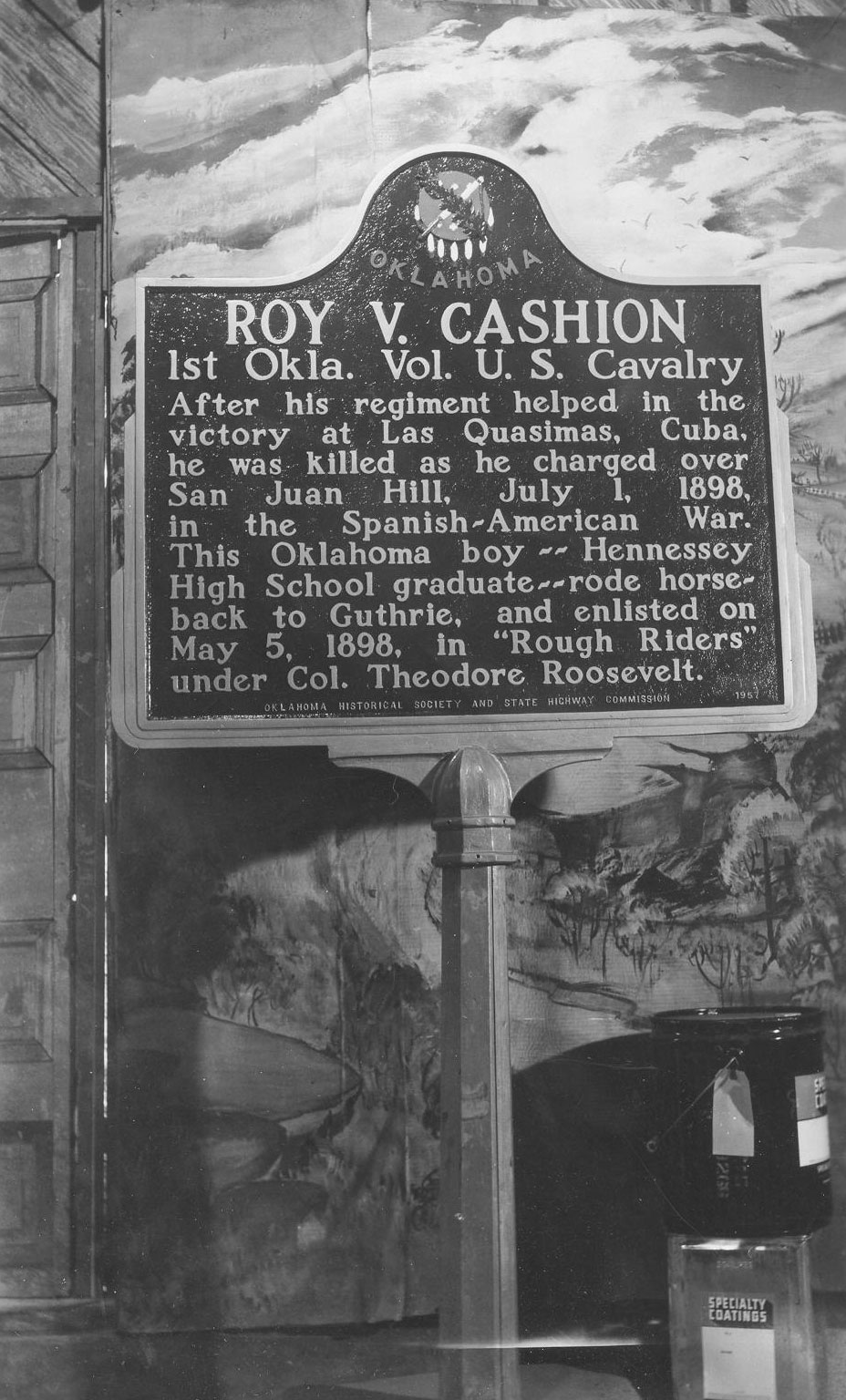
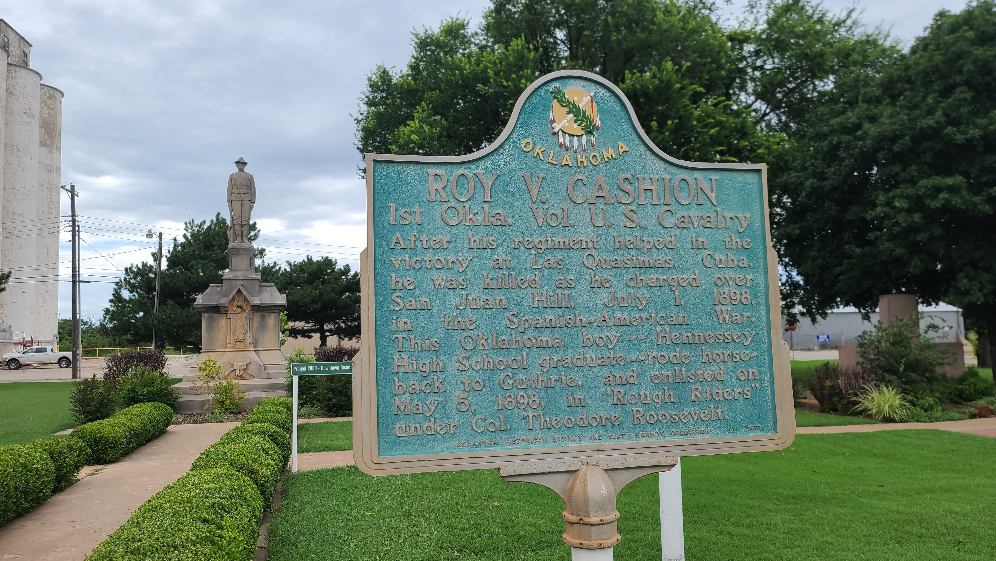
Roy V. Cashion, 1st Okla. Vol. U.S. Cavalry. After his regiment helped in the victory at Las Quasimas, Cuba, he was killed as he charged over San Juan Hill, July 1, 1898, in the Spanish-American War. This Oklahoma boy Hennessey High School graduate rode horseback to Guthrie, and enlisted on May 5, 1898, in Rough Riders under Col. Theodore Roosevelt.
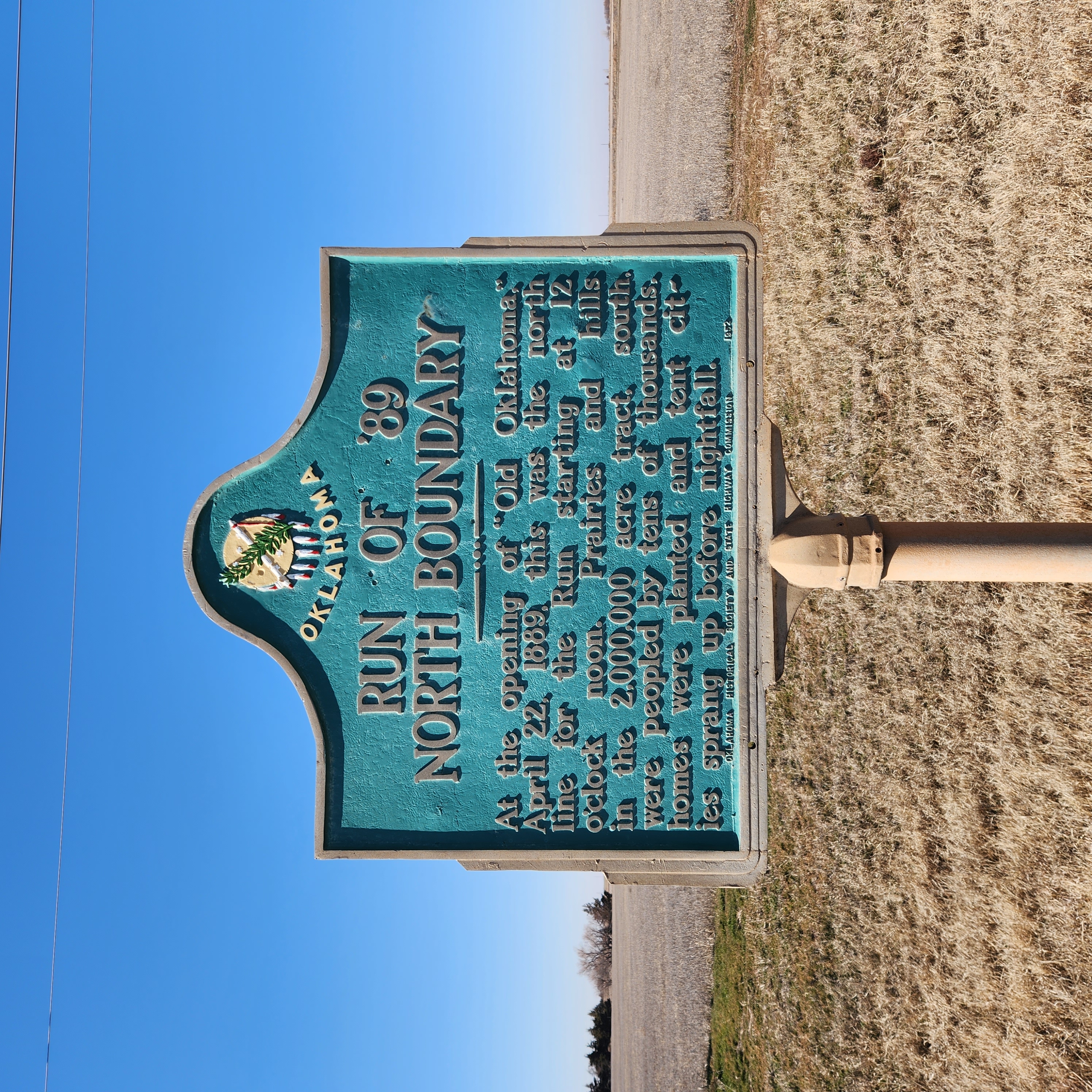
Location: on US-81, three miles north of Hennessey on Garfield-Kingfisher County line
Coordinates: 36.1643744,-97.8900608
Material: Aluminum
At the opening of "Old Oklahoma," April 22, 1889, this was the north line for the RUn starting at 12 o'clock noon. Prairies and hills in the 2,000,000 acre tract, south, were peopled by tens of thousands, homes were planted and tent cities sprang up before nightfall.
Location: on OK-3/OK-33 three miles west of Kingfisher, next to the Run of ’92 marker
Coordinates: 35.8549, -97.958200
Topics: Land Openings, Settlement Patterns, Territorial Period 1861–1907
The north-south line marked the west boundary of the two million acres of the Unassigned Lands settled by land run on April 22, 1889.
Location: on OK-33, two miles west of intersection with US-81
Coordinates: 35.854917, -97.958167
Material: Aluminum
Topics: American Indians, Land Openings, Settlement Patterns, Territorial Period 1861–1907
The Cheyenne-Arapaho lands were opened to public settlement on April 19, 1892, by land run. The east boundary of the area was longitude 98 degrees west at this location.
Location: on US-81, three miles north of Hennessey on Garfield-Kingfisher County line
Note: Marker may be missing
Topics: Land Openings, Settlement Patterns, Government
This site marks the east-west boundary line between the Unassigned Lands, opened on April 22, 1889, and the Cherokee Outlet, opened on September 16, 1893.
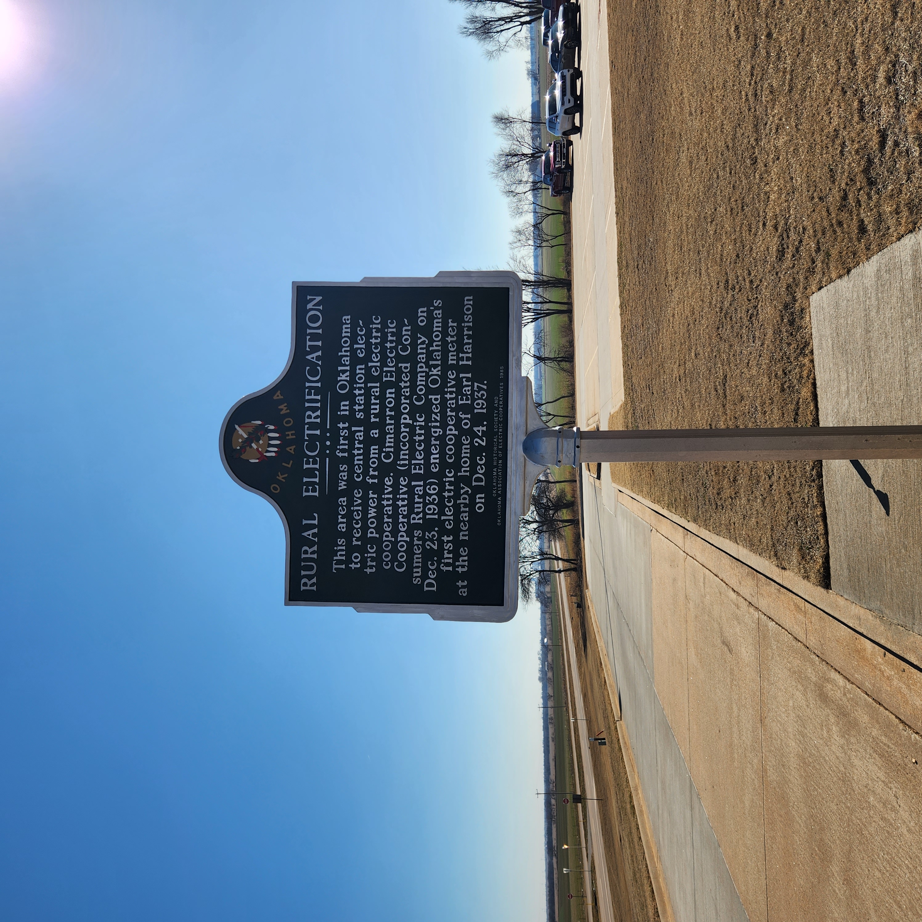
Location: on US-81, one mile north of Kingfisher
Coordinates: 35.8943648,-97.9336192
Material: Aluminum
Topics: Industry/Business, Social/Cultural, Agriculture, Early Statehood 1907–1941
Consumers Rural Electric Company was formed on December 23, 1936, and established the first rural electric cooperative in Oklahoma (later known as Cimarron Electric Cooperative). On Christmas Eve of 1937, the first home in Oklahoma to receive power from a rural electric cooperative was that of Earl Harrison.
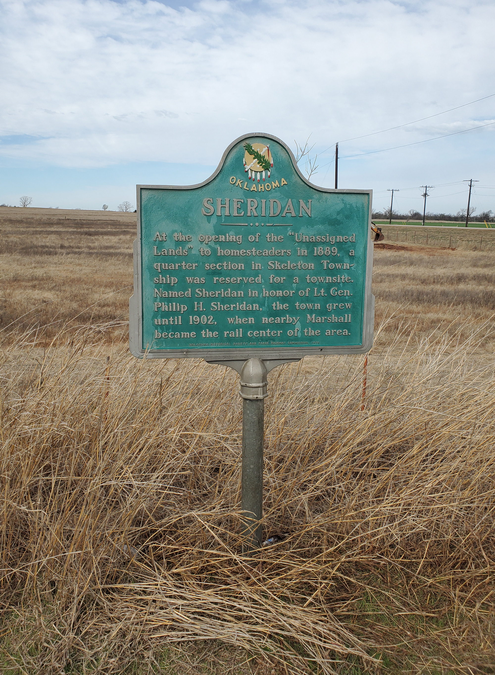
Location: on OK-51, ten miles east of Hennessey
Coordinates: 36.115622, -97.711296
Material: Aluminum
Topics: Land Openings, Settlement Patterns, Urban Development, Territorial Period 1861–1907
At the opening of the Unassigned Lands to homesteaders on April 22, 1889, a quarter-section in the Skeleton Township was reserved for a townsite named in honor of Lieutenant General Philip H. Sheridan. The town flourished until 1902 when Marshall became the rail center of the area.
Location: 3 1/2 miles north of Hennessey on the east side of US-81
Note: Marker may be missing
Topics: Land Openings
Le Flore County
Lincoln County
Logan County
Love County
Marshall County
Mayes County
McClain County
McCurtain County
McIntosh County
Murray County
Muskogee County
Noble County
Okfuskee County
Oklahoma County
Okmulgee County
Osage County
Ottawa County
Pawnee County
Payne County
Pittsburg County
Pontotoc County
Pottawatomie County
Pushmataha County
Roger Mills County
Rogers County
Seminole County
Sequoyah County
Stephens County
Texas County
Tillman County
Tulsa County
Wagoner County
Washington County
Washita County
Woods County
Woodward County
Historical Marker Program
Search Results
Your search returned 22 results.
Baker's Ranch
Kingfisher CountyLocation: the west side of US-81, four miles south of Hennessey
Coordinates: 36.0564576,-97.8995264
Material: Granite
Topics: Ranching, Territorial Period 1861–1907
Site one-half mile west. This ranch station, noted water place on the old Chisholm Trail, was attacked in the last Indian Wars and found deserted a few days later, July 5, 1874, by Indian Agent J. D. Miles, who asked for U.S. Cavalry to guard the trail in this section. This site was laid out in 1890 as Baker City, a ghost town now.
Big Four School
Kingfisher CountyLocation: east of Kingfisher on State Hwy 33 on SE corner of SE 1/4 of 14-16-6
Coordinates: 35.856528, -97.798852
Material: Granite
Big Four School, located three miles north, was formed on March 17, 1920, by a special election vote to consolidate the districts of White Cap, Twilight, Wandell, and Bird Creek. The school graduated its first senior class in 1924; its last in 1968. It continued as a grade school until closing in May 1978.
Bull Foot Station
Kingfisher CountyLocation: west of US-81 in Bull Foot Park, Hennessey
Coordinates: 36.1003327,-97.9004032
Material: Granite
Topics: Water, Ranching, Transportation, Folklife
On the old Chisholm Trail, this station was noted for its water well. The name from a huge indentation in the ground here, resembling imprint of a bull's foot. Buildings were still standing on site, 50 yards east of the old trail, and 4.5 miles south of the north line of the Oklahoma land, which was opened to settlers by the great run, April 22, 1889.
Chisholm Trail
Kingfisher CountyLocation: on US-81 at north edge of Dover
Material: Granite
Note: Marker may be missing
Topics: American Indians, Indian and Frontier Trade, Transportation, Ranching, Westward Expansion 1803–1861
A pioneer merchant, trader, and explorer, Jesse Chisholm, a mix-blood Cherokee, established a trail through western Indian Territory before the Civil War. Texas cattlemen used the trail until the late 1880s to move millions of cattle to northern markets. The trail ran from Montague County, Texas, to Abilene, Kansas.
First Rural Mail Route
Kingfisher CountyLocation: on US-81 in Memorial Park in Hennessey
Coordinates: 36.1108233,-97.8993253
Material: Aluminum
Topics: Government, Mass Communication, Transportation, Territorial Period 1861–1907
Oklahoma's 1st rural mail route was established at Hennessey on August 15, 1900, with Albert W. Darrow as carrier, his salary at $500 a year. J. A. Felt was the Hennessey postmaster. Route ran east over 24 miles, serving population of 700, in 31 square miles.
Kingfisher
Kingfisher CountyLocation: on US-81, present grounds of the post office in Kingfisher
Coordinates: 35.8643008,-97.9328127
Material: Aluminum
Topics: Transportation, Social/Cultural, Territorial Period 1861–1907, Ranching, Land Openings
This was U.S. Land Office site for filing claims at opening of "Old Oklahoma," April 22, 1889; also, at opening of Cheyenne and Arapaho lands on April 19, 1892. J. C. Robberts was first Register and J. V. Admire, first Receiver. First post office, Lisbon, established April 20, 1899; name changed to Kingfisher, July 18, 1889.
Kingfisher College
Kingfisher CountyLocation: on OK-33 on east side of Kingfisher
Coordinates: 35.856833, -97.906900
Material: Aluminum
Topics: Education, Religion/Philosophy, Territorial Period 1861–1907, Early Statehood 1907–1941
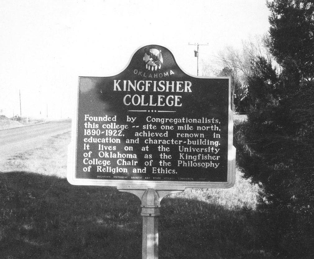
The Congregationalists founded the Kingfisher College in 1890. When the school closed in 1922, its endowment was transferred to the University of Oklahoma to fund the Kingfisher Chair of Religion and Ethics.
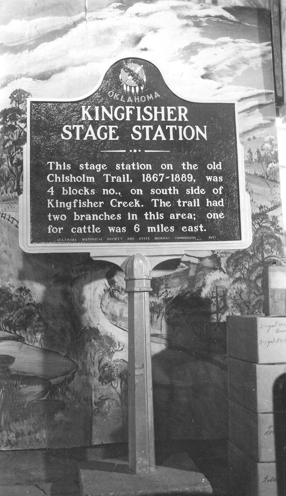
Kingfisher Stage Station
Kingfisher CountyLocation: on OK-33, one mile west of Kingfisher
Coordinates: 35.860633, -97.941133
Material: Aluminum
Topics: Transportation, Ranching, Urban Development, Social/Cultural, Land Openings, Government, Settlement Patterns
This stage stop on the old Chisholm Trail from 1867 to 1889 and the town were named for King Fisher, owner of the station. See Chisholm Trail.
Kingfisher-US Land Office
Kingfisher CountyLocation: on US-81 on grounds of Kingfisher post office
Material: Aluminum
Note: Marker may be missing
From a land office at this location, the federal government prescribed rules and regulations governing the opening of the Unassigned Lands in central Oklahoma on April 22, 1889. The office also registered claims for the April 19, 1892, opening of Cheyenne and Arapaho lands.
Lacey
Kingfisher CountyLocation: on OK-51, ten miles west of Hennessey
Coordinates: 36.116037, -98.085605
Material: Granite
Topics: Government, Social/Cultural, Land Openings, Settlement Patterns
The town of Lacey was named for Congressman John F. Lacey of Iowa, chairman of the House Public Lands Committee, who crafted much of the legislation that allowed the opening of lands in Oklahoma to public settlement.
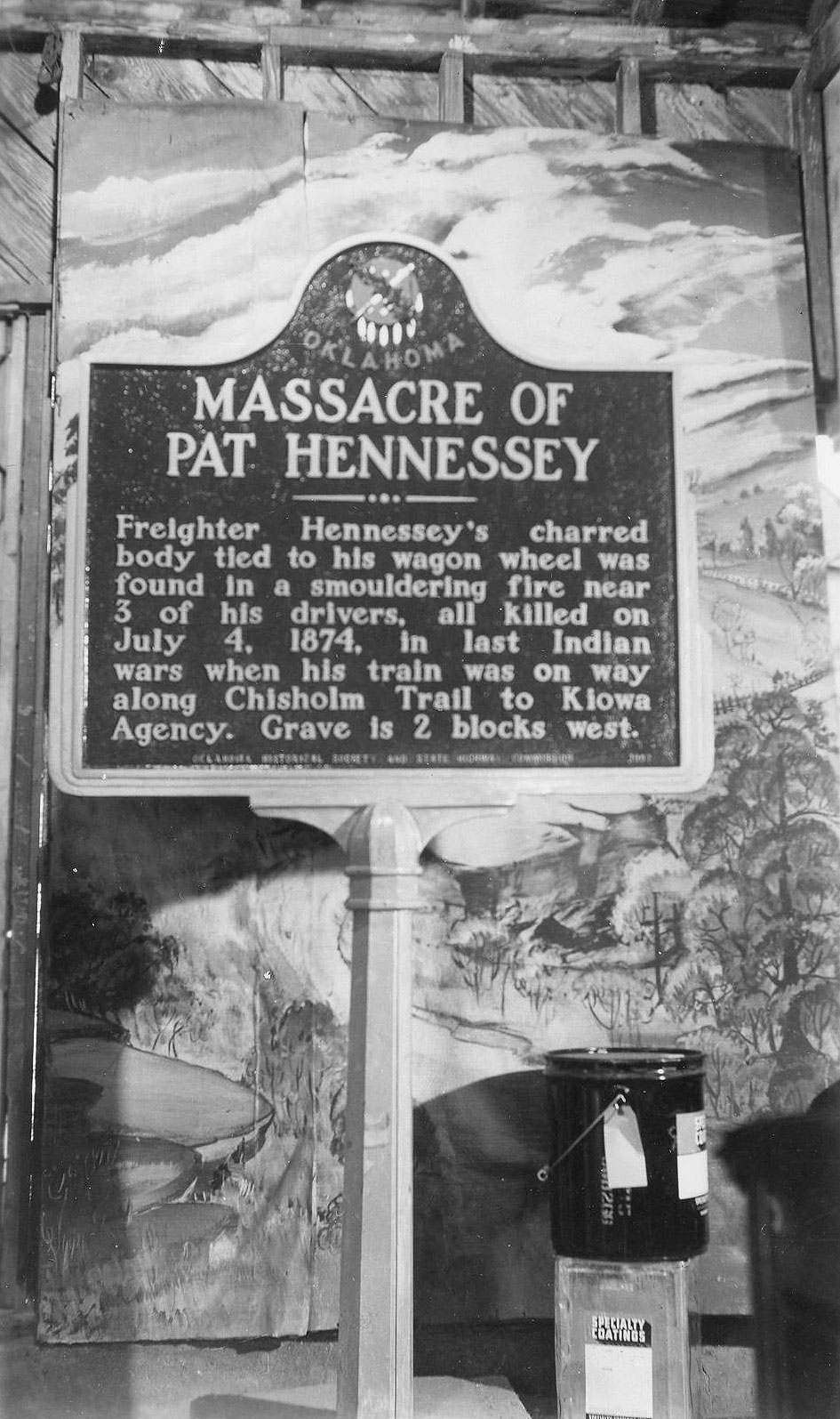
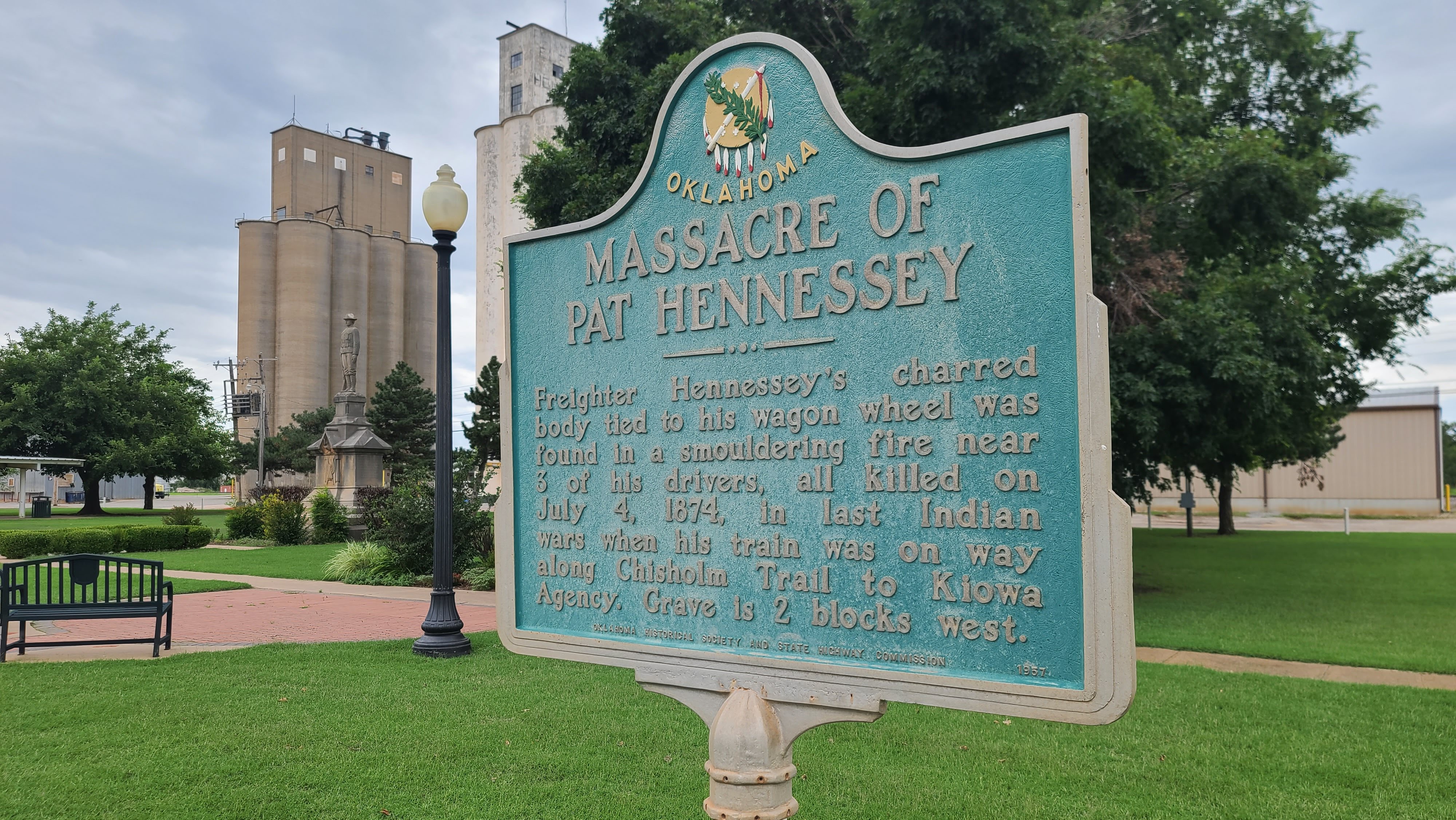
Massacre of Pat Hennessey
Kingfisher CountyLocation: on US-81 in Memorial Park in Hennessey
Coordinates: 36.111395, -97.899118
Material: Aluminum
Topics: Transportation, Indian and Frontier Trade, Territorial Period 1861–1907, American Indians
Freighter Pat Hennessey's charred body tied to his wagon wheel was found in a smoldering fire near 3 of his drivers, all killed on Jul 6, 1874, in last Indian wars when his train was on way along Chisholm Trail to Kiowa Agency. Grave is 2 blocks west.
Oklahoma Historical Society Birthplace
Kingfisher CountyLocation: on grounds of county courthouse at Kingfisher
Coordinates: 35.860717, -97.932500
Material: Aluminum
Topics: Mass Communication, Social/Cultural, Territorial Period 1861–1907
The Oklahoma Press Association founded the Oklahoma Historical Society (OHS) at its convention in Kingfisher on May 27, 1893. The purpose of the new organization was to preserve files on all publications of Oklahoma and Indian territories and documents relating to the history of the region. The OHS headquarters remained in Kingfisher until 1895 when it was moved to Norman. The OHS moved to Oklahoma City in 1901.
Red Fork Ranch 1872–1889
Kingfisher CountyLocation: at Hwy-81 and Red Ford Drive, Dover
Sponsored by: Citizens and Friends of Dover, 1998
Material: Granite
Note: Marker may be missing
Topics: Indian and Frontier Trade, Ranching, Territorial Period 1861–1907, Land Openings, Agriculture, Urban Development
On this site once stood the trading post known as the Red Fork Ranch. The original ranch building was constructed in 1872 by the Lee and Reynolds Company. Over the following years, the ranch was operated by a number of different individuals, the last being John G. Chapin, who was operating the ranch when the Unassigned Lands were opened on April 22, 1889. Chapin formally claimed the homestead which included the townsite of Dover and which was platted by him in 1892. John Chapin could well be characterized as "the father of Dover".
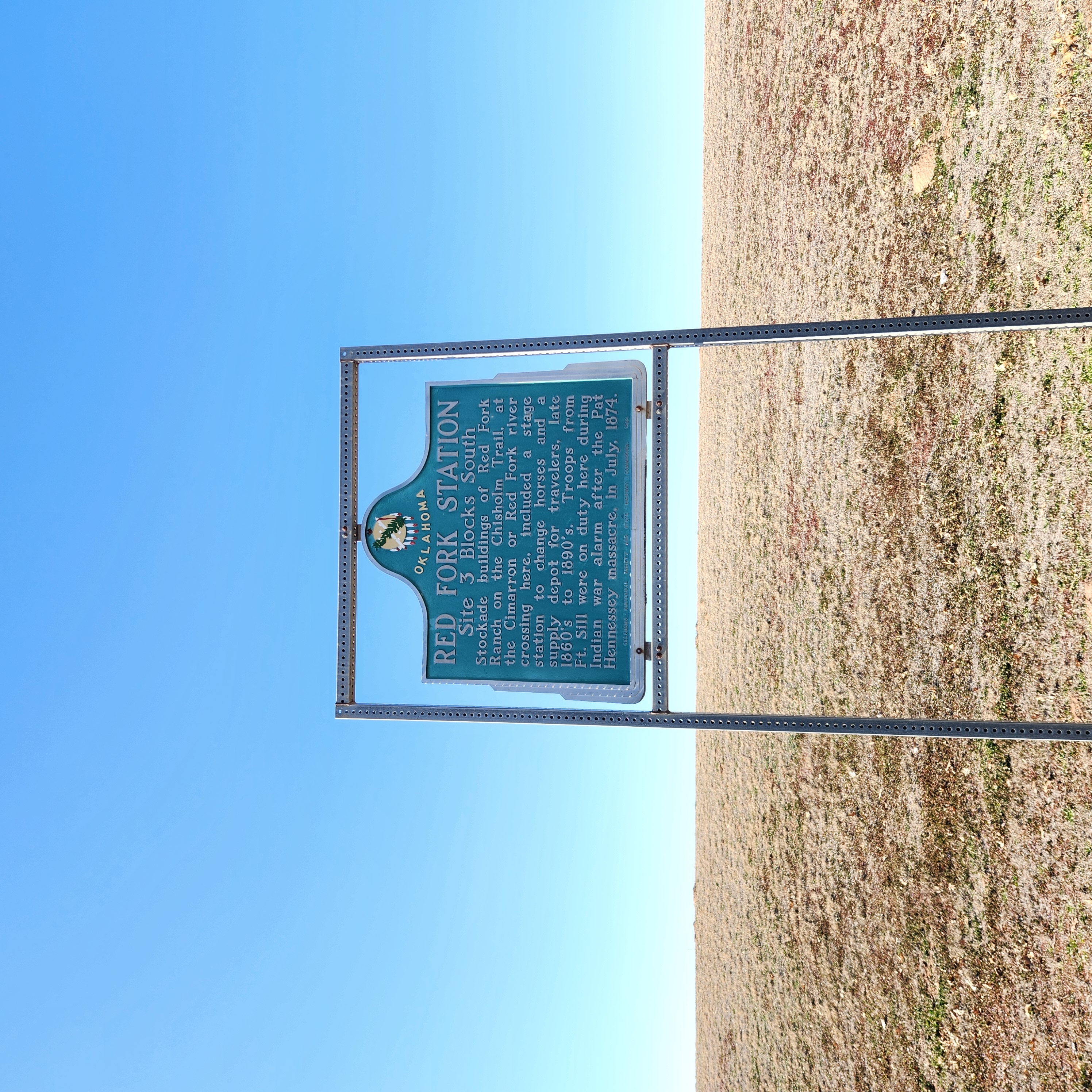
Red Fork Station
Kingfisher CountyLocation: on US-81 in Dover
Coordinates: 35.9868352,-97.9087232
Material: Aluminum
Topics: Transportation, Indian and Frontier Trade, Ranching, Military, American Indians
The stage station and supply depot was an important shipping point for cattle moving up to the Chisholm Trail. Soldiers from Fort Sill fortified Red Fork during the Cheyenne and Arapaho uprising in 1874. The station was named for the first name of the Cimarron River-Red Fork of the Arkansas. See Chisholm Trail.
Roy V. Cashion
Kingfisher CountyLocation: on US-81 in Memorial Park in Hennessey
Coordinates: 36.111145, -97.899130
Material: Aluminum
Topics: Social/Cultural, Territorial Period 1861–1907, Military
Roy V. Cashion, 1st Okla. Vol. U.S. Cavalry. After his regiment helped in the victory at Las Quasimas, Cuba, he was killed as he charged over San Juan Hill, July 1, 1898, in the Spanish-American War. This Oklahoma boy Hennessey High School graduate rode horseback to Guthrie, and enlisted on May 5, 1898, in Rough Riders under Col. Theodore Roosevelt.
Run of '89 North Boundary
Kingfisher CountyLocation: on US-81, three miles north of Hennessey on Garfield-Kingfisher County line
Coordinates: 36.1643744,-97.8900608
Material: Aluminum
At the opening of "Old Oklahoma," April 22, 1889, this was the north line for the RUn starting at 12 o'clock noon. Prairies and hills in the 2,000,000 acre tract, south, were peopled by tens of thousands, homes were planted and tent cities sprang up before nightfall.
Run of '89 West Boundary
Kingfisher CountyLocation: on OK-3/OK-33 three miles west of Kingfisher, next to the Run of ’92 marker
Coordinates: 35.8549, -97.958200
Topics: Land Openings, Settlement Patterns, Territorial Period 1861–1907
The north-south line marked the west boundary of the two million acres of the Unassigned Lands settled by land run on April 22, 1889.
Run of '92
Kingfisher CountyLocation: on OK-33, two miles west of intersection with US-81
Coordinates: 35.854917, -97.958167
Material: Aluminum
Topics: American Indians, Land Openings, Settlement Patterns, Territorial Period 1861–1907
The Cheyenne-Arapaho lands were opened to public settlement on April 19, 1892, by land run. The east boundary of the area was longitude 98 degrees west at this location.
Run of '93 South Boundary
Kingfisher CountyLocation: on US-81, three miles north of Hennessey on Garfield-Kingfisher County line
Note: Marker may be missing
Topics: Land Openings, Settlement Patterns, Government
This site marks the east-west boundary line between the Unassigned Lands, opened on April 22, 1889, and the Cherokee Outlet, opened on September 16, 1893.
Rural Electrification
Kingfisher CountyLocation: on US-81, one mile north of Kingfisher
Coordinates: 35.8943648,-97.9336192
Material: Aluminum
Topics: Industry/Business, Social/Cultural, Agriculture, Early Statehood 1907–1941
Consumers Rural Electric Company was formed on December 23, 1936, and established the first rural electric cooperative in Oklahoma (later known as Cimarron Electric Cooperative). On Christmas Eve of 1937, the first home in Oklahoma to receive power from a rural electric cooperative was that of Earl Harrison.
Sheridan
Kingfisher CountyLocation: on OK-51, ten miles east of Hennessey
Coordinates: 36.115622, -97.711296
Material: Aluminum
Topics: Land Openings, Settlement Patterns, Urban Development, Territorial Period 1861–1907
At the opening of the Unassigned Lands to homesteaders on April 22, 1889, a quarter-section in the Skeleton Township was reserved for a townsite named in honor of Lieutenant General Philip H. Sheridan. The town flourished until 1902 when Marshall became the rail center of the area.
Unassigned Lands
Kingfisher CountyLocation: 3 1/2 miles north of Hennessey on the east side of US-81
Note: Marker may be missing
Topics: Land Openings
(Page 1 of 1)
Search for Markers
Search by keyword or browse by county to learn about more than 600 historical markers created to recognize key locations, events, and people in Oklahoma history.
Please note that some markers listed in this database may have been moved, damaged, or are no longer standing.
Browse by County
Adair County
Alfalfa County
Atoka County
Beaver County
Beckham County
Blaine County
Bryan County
Caddo County
Canadian County
Carter County
Cherokee County
Choctaw County
Cimarron County
Cleveland County
Comanche County
Cotton County
Craig County
Creek County
Custer County
Delaware County
Dewey County
Ellis County
Garfield County
Garvin County
Grady County
Grant County
Greer County
Harmon County
Harper County
Haskell County
Hughes County
Jackson County
Jefferson County
Johnston County
Kay County
Kingfisher County
Kiowa County
Latimer CountyAlfalfa County
Atoka County
Beaver County
Beckham County
Blaine County
Bryan County
Caddo County
Canadian County
Carter County
Cherokee County
Choctaw County
Cimarron County
Cleveland County
Comanche County
Cotton County
Craig County
Creek County
Custer County
Delaware County
Dewey County
Ellis County
Garfield County
Garvin County
Grady County
Grant County
Greer County
Harmon County
Harper County
Haskell County
Hughes County
Jackson County
Jefferson County
Johnston County
Kay County
Kingfisher County
Kiowa County
Le Flore County
Lincoln County
Logan County
Love County
Marshall County
Mayes County
McClain County
McCurtain County
McIntosh County
Murray County
Muskogee County
Noble County
Okfuskee County
Oklahoma County
Okmulgee County
Osage County
Ottawa County
Pawnee County
Payne County
Pittsburg County
Pontotoc County
Pottawatomie County
Pushmataha County
Roger Mills County
Rogers County
Seminole County
Sequoyah County
Stephens County
Texas County
Tillman County
Tulsa County
Wagoner County
Washington County
Washita County
Woods County
Woodward County
Contact Us
If you have questions, please contact:
Matthew Pearce
Oklahoma Historical Society
800 Nazih Zuhdi Drive
Oklahoma City, OK 73105
405-522-8659
matthew.pearce@history.ok.gov