
Home | About OHS | Historical Marker Program
Location: in Hobart Cemetery
Topics: Education, Social/Cultural, Government
On Christmas Eve in 1924, thirty-six men, women, and children died in a fire that raged through the country school during a Christmas program. Candles ignited a Christmas tree and spread to new paint on the walls. The doors were built to open inward, and when people crowded them to escape, they were trampled. The fire resulted in new laws that required school exit doors to open outward.
Location: on US-183, one mile north of Mountain Park
Topics: Military, American Indians, Government, Westward Expansion 1803–1861
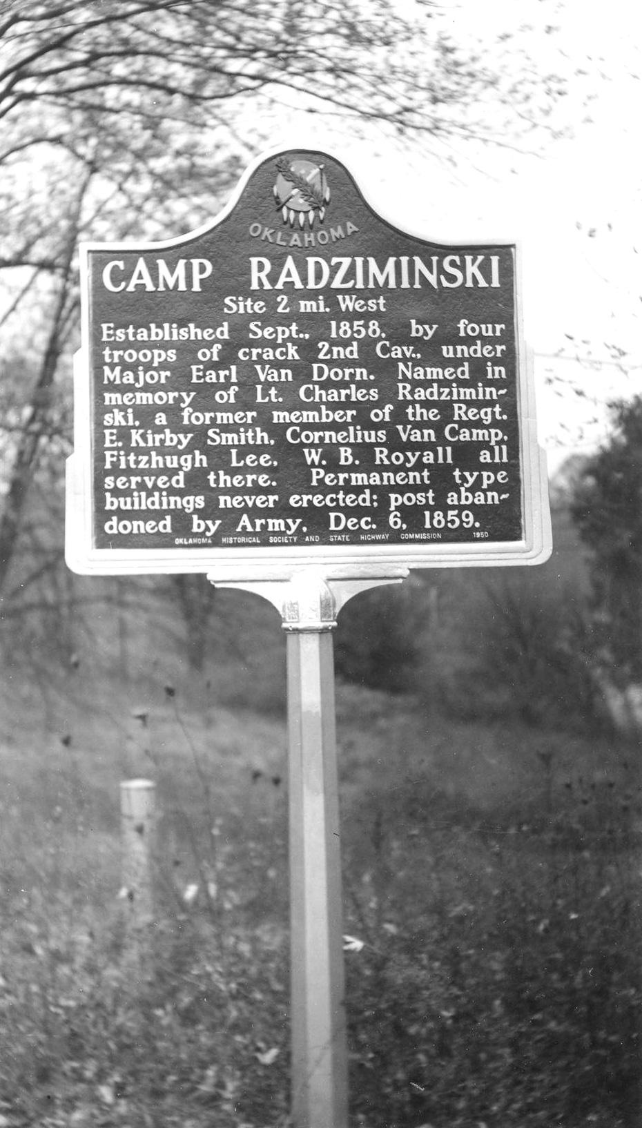
This frontier army post was manned by troops resisting hostile Indians. The camp was named for Lieutenant Charles Radziminski, a former member of the 2nd Cavalry under the command of Major Earl Van Dorn. Established in September of 1858, the post was used only a short time.
Location: in Quartz Mountain State Park
Topics: Government, Environmental/Cultural Ecology, Natural Resources, Social/Cultural, Recreational/Service
Members of Company 2810 of the Civilian Conservation Corps (CCC) built the state park from 1937 to 1939. Approximately 150 young men lived in tents and were paid $30 per month, of which $25 was sent to their homes. CCC members built trails, roads, shelters, picnic tables, and cabins, and landscaped the park.
Location: in Quartz Mountain State Park
Material: Granite
Topics: Military, Social/Cultural, Folklife
On March 5, 1869, William Gruber, the popular young bugler of the 19th Kansas Cavalry, was killed in a hunting accident while his regiment was in bivouac in the area. He was buried at dawn with the honors of war.
Material: Granite
Topics: Education, Settlement Patterns
Commemorating the dedication, foresight, and skill of teachers, administrators, and early residents who built these schools and the Con 8 community.
Location: in Quartz Mountain State Park
Material: Granite
Topics: Military, Transportation, American Indians, Government, Territorial Period 1861–1907
On March 5, 1869, General George Armstrong Custer and two cavalry regiments met a large supply train dispatched from Camp Supply by General Philip H. Sheridan. Three days earlier, Custer and his troops had departed Medicine Creek Camp, later Fort Sill, on an expedition against Plains Indians.
Location: on OK-54, two miles south of Cooperton
Topics: American Indians, Westward Expansion 1803–1861
In the spring of 1833, an Osage war party attacked an undefended Kiowa camp nearby, killing many elderly men, women, and children. Young braves had left the camp days earlier to hunt buffalo in the Quartz Mountains.
Location: at 600 South Dunn Street, Roosevelt
Sponsored by: Brook Roberts
Topics: Education, Territorial Period 1861–1907
The Fairview School House was one of the largest pioneer schools in Kiowa County. Constructed in 1903, it was a one-room school until 1916 when another room was added. It was located on R. W. and Alice Henderson's land in the northwest corner of Section 17 Township 4 Range 16. The school was transferred to Roosevelt School property in town when the prairie schools consolidated to Roosevelt High School.
Location: in Great Plains State Park
Topics: Mining, Natural Resources, Early Statehood 1907–1941, Industry/Business
The Gold Belle (or Bell) was one of several gold-mining shafts in the Wichita Mountains during a flurry of prospecting activity in the early twentieth century. The Gold Belle shaft was capitalized for $500,000 in 1903 but failed to produce paying ore. It was abandoned by 1914.
Location: on the west side of Hwy 44 near the Lugert grain elevator
Sponsored by: Terri Stern
Topics: Ethnic Diversity, Land Openings, Government, Retail, Territorial Period 1861–1907, Early Statehood 1907–1941, Industrial Period 1892–1941
Austrian immigrant Frank Lugert (1868–1958) founded the town of Lugert when the Kiowa-Comanche-Apache Reservation opened for settlement in 1901. Mr. Lugert ran the post office, train depot, and a general store. The town thrived until 1912 when a tornado destroyed it. In 1947 the dam was completed, covering the townsite.
Location: at intersection of OK-9 and OK-115, one mile east of Mountain View
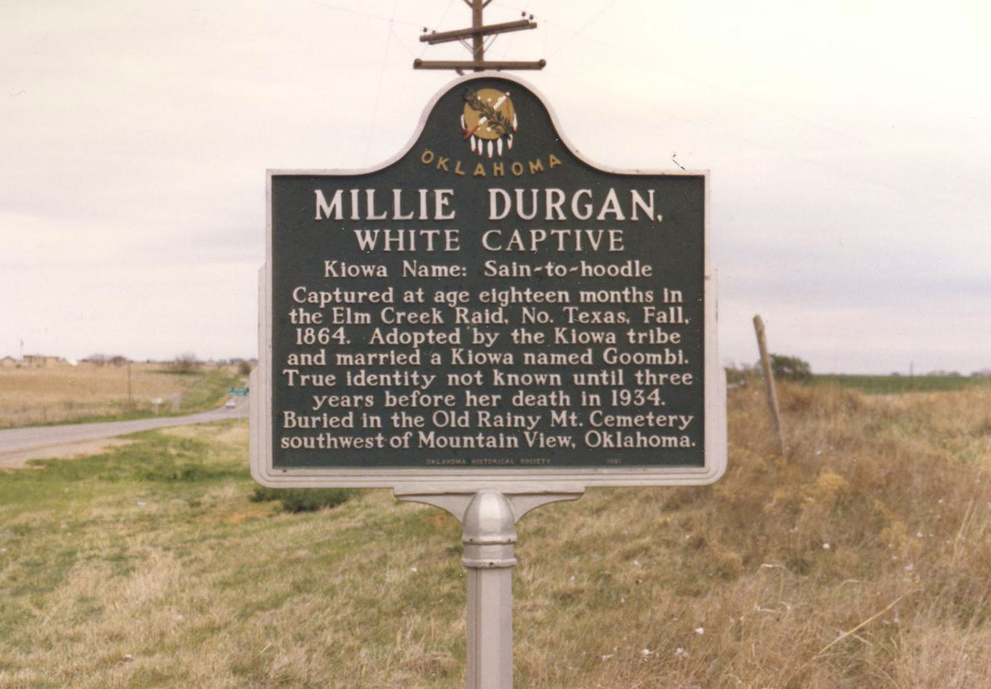
Topics: American Indians, Social/Cultural, Territorial Period 1861–1907
Millie Durgan was 18 months old when she was captured by Kiowa Indians in the Elm Creek Raid in north Texas in 1864. The girl was adopted by the Kiowa tribe and later married a Kiowa.
Location: on OK-115, 1 1/2 miles north of Mountain View
Topics: Government, Settlement Patterns, Territorial Period 1861–1907, Urban Development
Because of an error in the original survey, Mountain View was established in Washita County in 1899. When the error was discovered, the town was moved two miles southwest into Kiowa County because the legal proceedings to approve the first site were invalid.
Location: on US-62, eleven miles west of Cache
Material: Granite
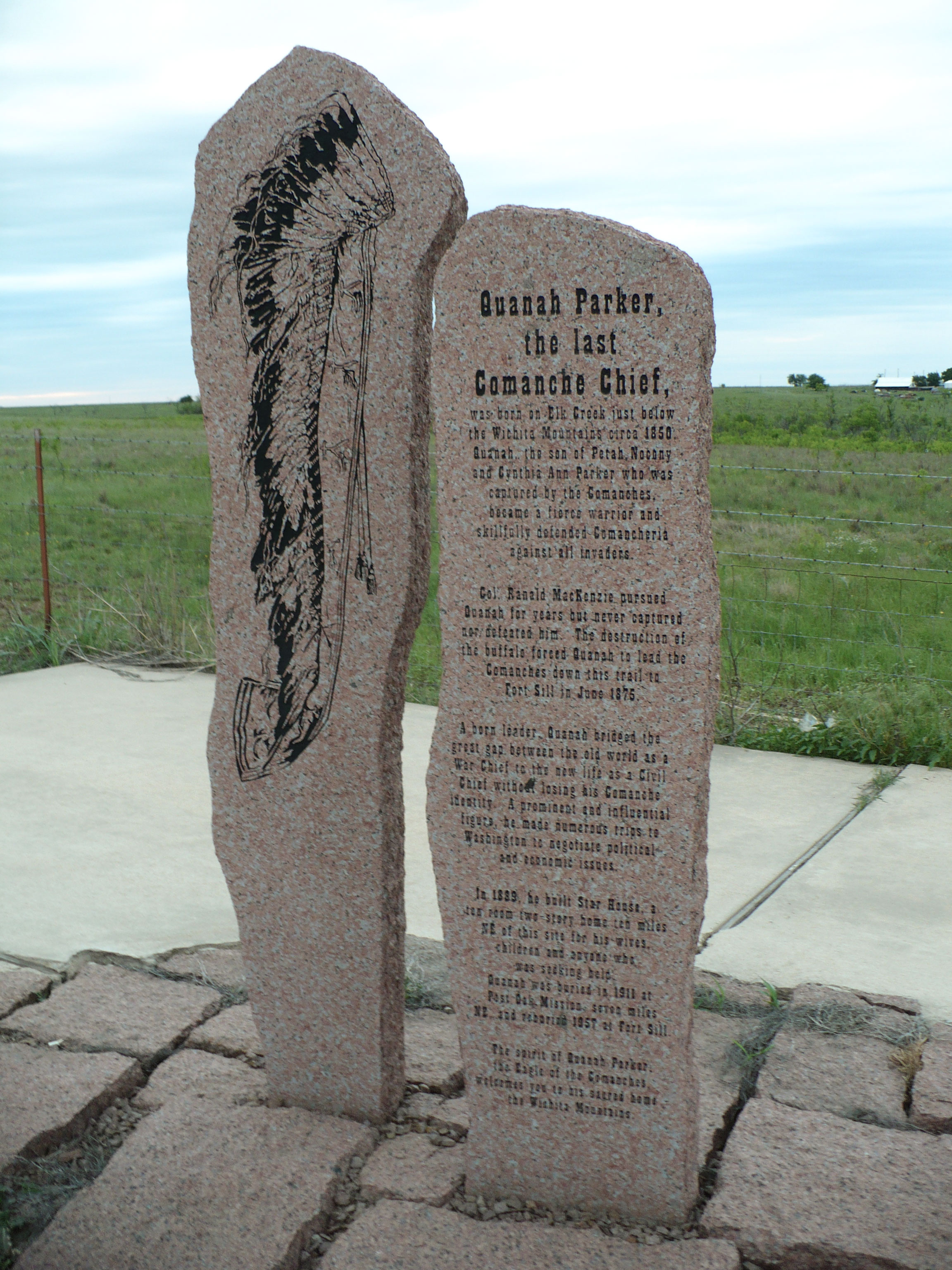
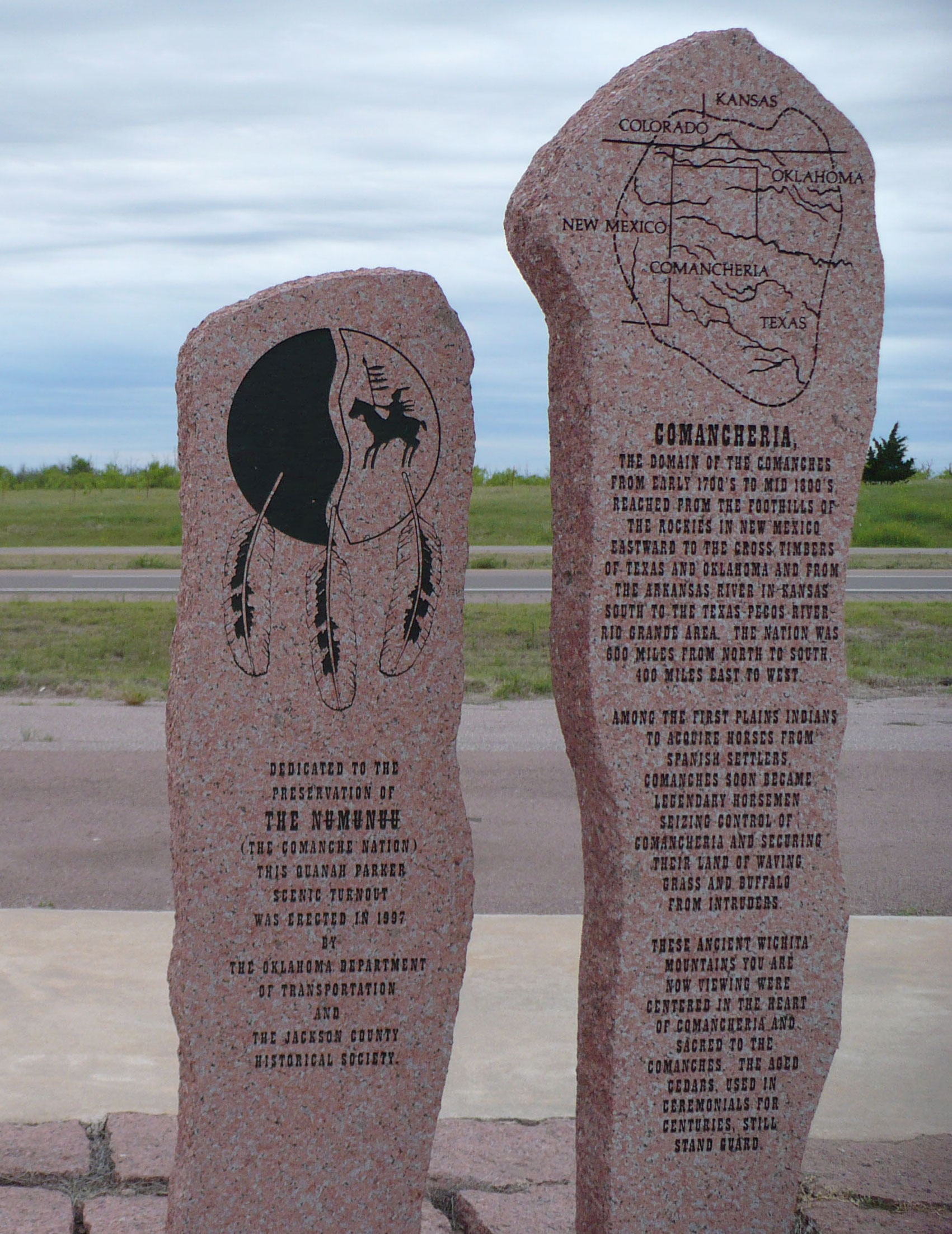
Topics: American Indians, Westward Expansion 1803–1861, Territorial Period 1861–1907, Family/Household
The last Comanche chief, born in 1850 in the Wichita Mountains, bridged the gap between the old world as a war chief and the new world as a civil chief without losing his Comanche identity. Parker avoided capture for many years before leading the Comanche peacefully to Fort Sill in 1875. In 1889, he built Star House, a ten-room home, for his wives and children. He died in 1911 and was buried at Post Oak Mission. His remains were moved to Fort Sill in 1957.
Location: south of Gotebo Hwy 54 near Rainy Mountain
Topics: American Indians, Education
Le Flore County
Lincoln County
Logan County
Love County
Marshall County
Mayes County
McClain County
McCurtain County
McIntosh County
Murray County
Muskogee County
Noble County
Okfuskee County
Oklahoma County
Okmulgee County
Osage County
Ottawa County
Pawnee County
Payne County
Pittsburg County
Pontotoc County
Pottawatomie County
Pushmataha County
Roger Mills County
Rogers County
Seminole County
Sequoyah County
Stephens County
Texas County
Tillman County
Tulsa County
Wagoner County
Washington County
Washita County
Woods County
Woodward County
Historical Marker Program
Search Results
Your search returned 14 results.
Babbs Switch Fire
Kiowa CountyLocation: in Hobart Cemetery
Topics: Education, Social/Cultural, Government
On Christmas Eve in 1924, thirty-six men, women, and children died in a fire that raged through the country school during a Christmas program. Candles ignited a Christmas tree and spread to new paint on the walls. The doors were built to open inward, and when people crowded them to escape, they were trampled. The fire resulted in new laws that required school exit doors to open outward.
Camp Radziminski
Kiowa CountyLocation: on US-183, one mile north of Mountain Park
Topics: Military, American Indians, Government, Westward Expansion 1803–1861
This frontier army post was manned by troops resisting hostile Indians. The camp was named for Lieutenant Charles Radziminski, a former member of the 2nd Cavalry under the command of Major Earl Van Dorn. Established in September of 1858, the post was used only a short time.
CCC-Quartz Mountain State Park
Kiowa CountyLocation: in Quartz Mountain State Park
Topics: Government, Environmental/Cultural Ecology, Natural Resources, Social/Cultural, Recreational/Service
Members of Company 2810 of the Civilian Conservation Corps (CCC) built the state park from 1937 to 1939. Approximately 150 young men lived in tents and were paid $30 per month, of which $25 was sent to their homes. CCC members built trails, roads, shelters, picnic tables, and cabins, and landscaped the park.
Chief Bugler's Grave
Kiowa CountyLocation: in Quartz Mountain State Park
Material: Granite
Topics: Military, Social/Cultural, Folklife
On March 5, 1869, William Gruber, the popular young bugler of the 19th Kansas Cavalry, was killed in a hunting accident while his regiment was in bivouac in the area. He was buried at dawn with the honors of war.
Consolidated Dist. No. 8
Kiowa CountyMaterial: Granite
Topics: Education, Settlement Patterns
Commemorating the dedication, foresight, and skill of teachers, administrators, and early residents who built these schools and the Con 8 community.
Custer's Rendezvous
Kiowa CountyLocation: in Quartz Mountain State Park
Material: Granite
Topics: Military, Transportation, American Indians, Government, Territorial Period 1861–1907
On March 5, 1869, General George Armstrong Custer and two cavalry regiments met a large supply train dispatched from Camp Supply by General Philip H. Sheridan. Three days earlier, Custer and his troops had departed Medicine Creek Camp, later Fort Sill, on an expedition against Plains Indians.
Cut Throat Gap Massacre
Kiowa CountyLocation: on OK-54, two miles south of Cooperton
Topics: American Indians, Westward Expansion 1803–1861
In the spring of 1833, an Osage war party attacked an undefended Kiowa camp nearby, killing many elderly men, women, and children. Young braves had left the camp days earlier to hunt buffalo in the Quartz Mountains.
Fairview School House
Kiowa CountyLocation: at 600 South Dunn Street, Roosevelt
Sponsored by: Brook Roberts
Topics: Education, Territorial Period 1861–1907
The Fairview School House was one of the largest pioneer schools in Kiowa County. Constructed in 1903, it was a one-room school until 1916 when another room was added. It was located on R. W. and Alice Henderson's land in the northwest corner of Section 17 Township 4 Range 16. The school was transferred to Roosevelt School property in town when the prairie schools consolidated to Roosevelt High School.
Gold Belle Mine
Kiowa CountyLocation: in Great Plains State Park
Topics: Mining, Natural Resources, Early Statehood 1907–1941, Industry/Business
The Gold Belle (or Bell) was one of several gold-mining shafts in the Wichita Mountains during a flurry of prospecting activity in the early twentieth century. The Gold Belle shaft was capitalized for $500,000 in 1903 but failed to produce paying ore. It was abandoned by 1914.
Lugert
Kiowa CountyLocation: on the west side of Hwy 44 near the Lugert grain elevator
Sponsored by: Terri Stern
Topics: Ethnic Diversity, Land Openings, Government, Retail, Territorial Period 1861–1907, Early Statehood 1907–1941, Industrial Period 1892–1941
Austrian immigrant Frank Lugert (1868–1958) founded the town of Lugert when the Kiowa-Comanche-Apache Reservation opened for settlement in 1901. Mr. Lugert ran the post office, train depot, and a general store. The town thrived until 1912 when a tornado destroyed it. In 1947 the dam was completed, covering the townsite.
Millie Durgan
Kiowa CountyLocation: at intersection of OK-9 and OK-115, one mile east of Mountain View
Topics: American Indians, Social/Cultural, Territorial Period 1861–1907
Millie Durgan was 18 months old when she was captured by Kiowa Indians in the Elm Creek Raid in north Texas in 1864. The girl was adopted by the Kiowa tribe and later married a Kiowa.
Old Mountain View Townsite
Kiowa CountyLocation: on OK-115, 1 1/2 miles north of Mountain View
Topics: Government, Settlement Patterns, Territorial Period 1861–1907, Urban Development
Because of an error in the original survey, Mountain View was established in Washita County in 1899. When the error was discovered, the town was moved two miles southwest into Kiowa County because the legal proceedings to approve the first site were invalid.
Quanah Parker
Kiowa CountyLocation: on US-62, eleven miles west of Cache
Material: Granite
Topics: American Indians, Westward Expansion 1803–1861, Territorial Period 1861–1907, Family/Household
The last Comanche chief, born in 1850 in the Wichita Mountains, bridged the gap between the old world as a war chief and the new world as a civil chief without losing his Comanche identity. Parker avoided capture for many years before leading the Comanche peacefully to Fort Sill in 1875. In 1889, he built Star House, a ten-room home, for his wives and children. He died in 1911 and was buried at Post Oak Mission. His remains were moved to Fort Sill in 1957.
Rainey Mountain Boarding School
Kiowa CountyLocation: south of Gotebo Hwy 54 near Rainy Mountain
Topics: American Indians, Education
(Page 1 of 1)
Search for Markers
Search by keyword or browse by county to learn about more than 600 historical markers created to recognize key locations, events, and people in Oklahoma history.
Please note that some markers listed in this database may have been moved, damaged, or are no longer standing.
Browse by County
Adair County
Alfalfa County
Atoka County
Beaver County
Beckham County
Blaine County
Bryan County
Caddo County
Canadian County
Carter County
Cherokee County
Choctaw County
Cimarron County
Cleveland County
Comanche County
Cotton County
Craig County
Creek County
Custer County
Delaware County
Dewey County
Ellis County
Garfield County
Garvin County
Grady County
Grant County
Greer County
Harmon County
Harper County
Haskell County
Hughes County
Jackson County
Jefferson County
Johnston County
Kay County
Kingfisher County
Kiowa County
Latimer CountyAlfalfa County
Atoka County
Beaver County
Beckham County
Blaine County
Bryan County
Caddo County
Canadian County
Carter County
Cherokee County
Choctaw County
Cimarron County
Cleveland County
Comanche County
Cotton County
Craig County
Creek County
Custer County
Delaware County
Dewey County
Ellis County
Garfield County
Garvin County
Grady County
Grant County
Greer County
Harmon County
Harper County
Haskell County
Hughes County
Jackson County
Jefferson County
Johnston County
Kay County
Kingfisher County
Kiowa County
Le Flore County
Lincoln County
Logan County
Love County
Marshall County
Mayes County
McClain County
McCurtain County
McIntosh County
Murray County
Muskogee County
Noble County
Okfuskee County
Oklahoma County
Okmulgee County
Osage County
Ottawa County
Pawnee County
Payne County
Pittsburg County
Pontotoc County
Pottawatomie County
Pushmataha County
Roger Mills County
Rogers County
Seminole County
Sequoyah County
Stephens County
Texas County
Tillman County
Tulsa County
Wagoner County
Washington County
Washita County
Woods County
Woodward County
Contact Us
If you have questions, please contact:
Matthew Pearce
Oklahoma Historical Society
800 Nazih Zuhdi Drive
Oklahoma City, OK 73105
405-522-8659
matthew.pearce@history.ok.gov