
Home | About OHS | Historical Marker Program
Location: 1001 N. Pennsylvania Oklahoma City, OK
Material: Aluminum
Topics: Industry/Business, Retail, Social/Cultural, Urban Development
A pioneer of the warehouse club retail industry, AMC was established by the Homsey brothers and operated on this site from 1961 until 1987. The Homseys fought in court to give business owners the right to set their own prices without interference by producers, won in the Oklahoma Supreme Court on April 18, 1961, and thus changed Oklahoma's retail environment.
Location: on the grounds of the Wiley Post Building, 2100 North Lincoln Boulevard, Oklahoma City
Material: Granite
Topics: Social/Cultural, Urban Development, Early Statehood 1907–1941, Government, Education
Oklahoma's premier pioneer architect, Layton designed the State Capitol (1914), the Oklahoma Historical Society building (1930), and other early Oklahoma City structures, including the Mid-Continent Life Insurance Building. Statewide, Layton and his associates designed more than a hundred buildings, including thirty-two buildings at six colleges (plus at least one in Texas), twenty-one government buildings, and more than forty schools. He also designed residences in a number of communities and even a subdivision in Ponca City for the Marland Company.
Location: on State Highway 66 between Luther and Arcadia
Location: at the southeast corner of Northwest 63rd Street and Pennsylvania Avenue in Oklahoma City (OBHC)
Topics: Social/Cultural, Territorial Period 1861–1907, Education
In 1903, J. A. Scott founded an orphans' home here. The name was changed to the Oklahoma Baptist Children's Home in 1936. In 1983 the property was sold, and a new campus opened on South Western Avenue in Oklahoma City.
Location: at Second Street and Boulevard in Edmond
Material: Aluminum
Topics: Education
The Oklahoma Territorial Legislature established the school for the training of teachers in December of 1890. Known as Central State Teachers College, Central State College, and Central State University, the institution is now the University of Central Oklahoma. Old North, built in 1892, is the oldest building on campus.
Location: on grounds of Wiley Post Building, 2100 North Lincoln Boulevard, Oklahoma City
Material: Aluminum
Topics: Military, Arts, Early Statehood 1907–1941
This three-inch, muzzle-loading field cannon was used in battle by the New Jersey Volunteer Artillery and for entertainment by Pawnee Bill's Wild West Show. Major Gordon W. Lillie (Pawnee Bill) gave the cannon to his long-time publicist Frank Stuart who kept it at his Nichols Hills home before bequeathing it to the Oklahoma Historical Society.
Location: five miles east, at Lacey and Sheridan
Topics: Agriculture, Government, Mass Communication, Transportation, Settlement Patterns
Located five miles to the east in old Oklahoma Territory, this agricultural community was the site of a post office from February 21, 1890, to February 28, 1913. Named for a local merchant, Columbus Fash, the town disappeared after being bypassed by the railroad.
Location: near Northwest Tenth Street and the North Canadian River in Bethany (DAR)
Coordinates: 35.479047, -97.663289
Sponsored by: Daughters of the American Revolution
Topics: American Indians, Indian and Frontier Trade, Westward Expansion 1803–1861, Military
Jesse Chisholm opened a trading post here in 1858. In 1865, Comanche and Kiowa met nearby with Confederate leaders. Barracks were constructed on the site to house soldiers to clear timber for the construction of Fort Reno.
Location: on West Reno Avenue in Oklahoma City
Material: Granite
Topics: Education, Territorial Period 1861–1907, Early Statehood 1907–1941, Mass Communication, Government
This was one of the first schools in Oklahoma County. It was later moved by wagon to the corner of Melrose Lane and Council Road. A second building was constructed in 1900 and the present red brick structure was completed in 1938. A post office was established at Council Grove on June 11, 1892. Two years later, the post office became Council but closed in 1906.
Location: on West Reno Avenue and South Western Avenue near the Oklahoma River in Oklahoma City
Material: Granite
Topics: Recreational/Service, Social/Cultural, Folklife, Territorial Period 1861–1907, Early Statehood 1907–1941
Once reportedly the largest amusement park west of the Mississippi River, Delmar Garden occupied 140 acres along the North Canadian River. The magnificent park, which boasted an outdoor theater, beer garden, dance hall, swimming pool, baseball park, and race track, opened barely a dozen years after Oklahoma City was carved out of a prairie. The park operated from 1902 to 1910 when a mosquito epidemic caused by high water closed the park. Apache Chief Geronimo once signed autographs here.
Location: on Broadway North of 2nd Street, Edmond
Material: Granite
Topics: Transportation
The Atchison, Topeka, and Santa Fe Railroad gave birth to Edmond, Oklahoma, in terms of location and name on April 22, 1889. During road construction it was known as Mile 103 or "Summit," a side stop on a high point (elev. 1198 feet) of the railway grade between the Cimarron and the North Canadian Rivers. On March 28, 1887, the stop was officially named "Edmond Station" for Edmond Burdick, the Santa Fe's traveling freight agent, and full train service began in June. The AT&SF's first coaling barn for the Unassigned Lands was located here. John N. Steen, the first permanent resident, completed the water well for the steam locomotives in May of 1888. The conical-covered well, pump house, water tower, depot, telegraph and express office that were along the railroad right-of-way from Third Street to north of west Second and the coaling barn near Fifth were "Edmond" before the land run. The name was retained by the '89ers who established the town around the station.
Location: Oklahoma Historical Society grounds
Topics: Timber, Folklife, Social/Cultural
Transplanted from Colonel A. P. Chouteau's post at Salina, Oklahoma's first permanent settlement, this tree is a descendant of the first trees planted in present-day Oklahoma by Chouteau in the early nineteenth century.
Location: southwest corner of Second and Boulevard in Edmond
Sponsored by: Edmond Historical Preservation Trust (City of Edmond)
Topics: Education, Social/Cultural
One of the first recognized official Oklahoma Centennial Projects was the preservation of Oklahoma Territory's first public schoolhouse, located in Edmond.
Location: on Tinker Air Force Base
Topics: Military, Industrial Period 1841–1892, Natural Resources
On March 25, 1948, two Tinker Air Force Base officers issued the first tornado forecast several hours before a tornado struck the base. Major Ernest J. Fawbush and Captain Robert C. Miller developed tornado forecasting techniques still in use today. Their work brought national attention to warning the public of potential danger of severe weather.
Location: on East Main Street at Museum
Sponsored by: Harrah Historical Society
Topics: American Indians, Westward Expansion 1803–1861, Transportation, Settlement Patterns, Territorial Period 1861–1907, Urban Development
The present site of Harrah was first settled in 1876 by French-Potawatomi Indian, Louis Navarre. In 1892, E. W. Sweeney built a bridge at a strategic ford across the North Canadian River, increasing the settlement's prospects. The railroad's arrival in 1896 assured success. Entrepreneur, Frank Harrah, purchased eighty acres from Navarre of which a portion was used for development. A forty-acre tract was surveyed, platted, and officially entered as the town of Harrah on February 18, 1899. This marker stands within the original tract in the heart of the town's early business district.
Location: in Rose Hill Cemetery, Oklahoma City
Material: Granite
Topics: Social/Cultural, Government, Territorial Period 1861–1907, Early Statehood 1907–1941
Joseph Thoburn (1866–1941), Oklahoma's pioneer historian, was born in Bellaire, Ohio, and reared and educated in Kansas. Thoburn was secretary of the Oklahoma Commercial Club and the Oklahoma Territorial Board of Agriculture. He was the director of the Oklahoma Historical Society for thirty-eight years and admitted to the Oklahoma Hall of Fame in 1932. He was also active in religious, educational, and civic works.
Location: in Gracelawn Cemetery in Edmond
Material: Granite
Topics: Mass Communication, Land Openings, Settlement Patterns, Folklife, Government, Territorial Period 1861–1907
Publisher and founder of the Edmond Sun, Milton W. "Kicking Bird" Reynolds was a nationally known newspaperman who promoted opening the Unassigned Lands in the 1880s. He made the Land Run of 1889 by train and is credited as being the first to call Oklahoma "Land of the Fair God." He was a member of Oklahoma's first territorial legislature. He died in 1890.
Location: Oklahoma Historical Society grounds
Material: Granite
Topics: Empire Period 1541–1803, Government, Settlement Patterns
The charter of 1663 granted a large section of land from the east coast to the west coast to eight Lords Proprietors and supporters of Charles II. Much of present-day Oklahoma is included in the proposed boundaries of this charter.
Location: on Second Street at the entrance to Holiday Inn Express
Topics: Settlement Patterns, Land Openings, Agriculture, Industry/Business, Transportation, Early Statehood 1907–1941
James and Katherine Kunc and son, William, made the run and homesteaded a quarter section on the southwest corner of Second and Sooner on April 22, 1889. In 1923, Everett Bradbury purchased one acre of land on the northeast corner of the homestead and established a campground and filling station. This intersection was the junction of US Highway 66 and US Highway 77 and became known as Bradbury Corner.
Location: on the grounds of the Oklahoma History Center, 800 Nazih Zuhdi Drive, Oklahoma City
Material: Granite
Topics: Government, Social/Cultural, Industrial Period 1841–1892
For the 1950 US Independence Savings Bond Drive, the government ordered one Liberty Bell replica for each state. Cast in France, this bell was transported around the state on a flatbed truck to promote the sale of savings bonds. It was originally located at the Wiley Post building in Oklahoma City, and was later moved to the Oklahoma History Center grounds.
Location: at 212 Northwest 15th Street in Oklahoma City (DAR)
Sponsored by: Daughters of the American Revolution
Topics: Recreational/Service, Social/Cultural, Folklife
The Oklahoma City Chapter of the Daughters of the American Revolution was organized in 1904 in the home of Mrs. Robert Carpenter.
Location: near the intersection of Southeast 59th and Bryant
Material: Granite
Topics: Petroleum, Natural Resources, Industry/Business, Early Statehood 1907–1941
On December 4, 1928, the Oklahoma City No. 1 blew, opening Oklahoma's most productive oil and gas field and the sixth largest in the nation. It was drilled by the Indian Territory Illuminating Oil Company, a subsidiary of Cities Service Oil Company and the Foster Petroleum Company. The well was deeded to the State of Oklahoma as a historic site after producing over a million barrels of oil.
Location: northeast corner of the Flag Plaza at State Capitol
Material: Granite
Topics: Petroleum, Natural Resources, Industry/Business, Early Statehood 1907–1941
The discovery of the famous Oklahoma City Oil Field was made by H. V. Foster, president of the Indian Territory Illuminating Oil Company, on December 4, 1928, when Oklahoma City No. 1 began production. Located at Southeast 57th Street and Indian Territory Illuminating Oil Company Boulevard, this well marked the beginning of a great rush for "black gold" in the area. The site is now under the control of the Oklahoma Historical Society.
Location: at Oklahoma City Zoo, NE 50th and Eastern in Oklahoma City
Material: Granite
Topics: Recreational/Service, Social/Cultural, Territorial Period 1861–1907
First in the southwest, the Oklahoma City Zoo was established in Wheeler Park in 1904. It was destroyed by the flood of 1923. It was then moved to Lincoln Park.
Location: at 800 Nazih Zudhi Drive, Oklahoma City
Topics: Recreational/Service, Social/Cultural, Early Statehood 1907–1941, Government
Containing one of the finer collections of Indian artifacts in the United States, this museum is the headquarters of the Oklahoma Historical Society. It portrays all aspects of Oklahoma's heritage, from its prehistoric Indian culture exhibits to its "Oklahoma in Space" display.
Location: at the Henry and Anna Overholser Mansion, 405 Northwest 15th Street in Oklahoma City
Material: Granite
Topics: Urban Development, Land Openings, Settlement Patterns, Arts, Family/Household, Transportation
Henry Overholser arrived in Oklahoma as an '89er and soon became a prominent civic leader. He worked tirelessly to bring several railroads to Oklahoma City and operated the Overholser Opera House for many years. He constructed this Victorian mansion in 1904. It became a showplace and the center of the city's social and cultural life.
Location: near intersection of Stanton L. Young and Lindsey in Oklahoma City (DAR)
Sponsored by: Daughters of the American Revolution
Topics: Transportation, Water, Land Openings
A nearby spring provided water for cattlemen and Indians prior to settlement. The campground was a favorite of Captain David L. Payne, the early leader of the Boomer movement for opening the Unassigned Lands.
Location: at 1401 NW 3rd Street, Oklahoma City
Topics: Manufacturing
On this site in 1936 R. W. Robberson located the Robberson Steel Company, opening a new industrial area in Oklahoma City. Beginning his career in 1913 with John Kline, 110 N. Francis, he acquired ownership in 1928. His foresight and initiative have for sixty-four years contributed to the industrial growth and progress of Oklahoma.
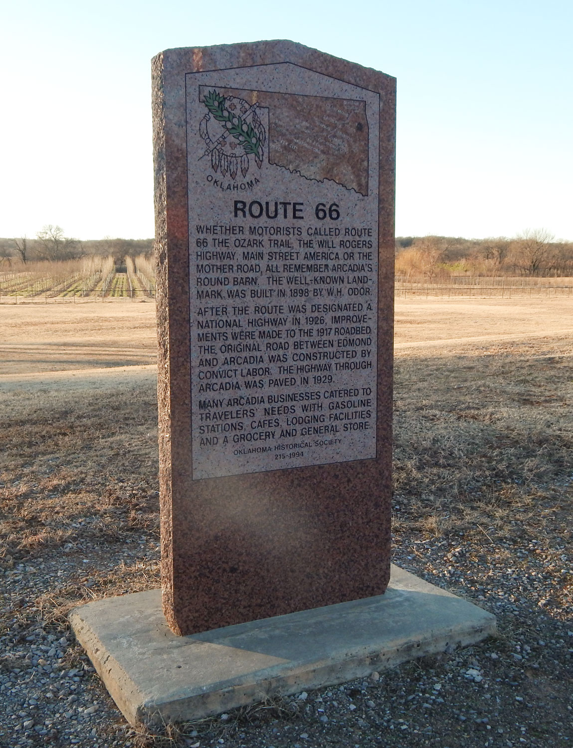
Location: on Route 66 in Arcadia, across from Round Barn
Material: Granite
Topics: Transportation
Whether motorists called Route 66 the Ozark Trail, the Will Rogers Highway, Main Street America or the Mother Road, all remember Arcadia's Round Barn. The well-known landmark was built in 1898 by W. H. Odor. After the route was designated a national highway in 1926, improvements were made to the 1917 roadbed. The original road between Edmond and Arcadia was constructed by convict labor. The highway through Arcadia was paved in 1929. Many Arcadia businesses catered to travelers' needs with gasoline stations, cafes, lodging facilities and a grocery and general store.
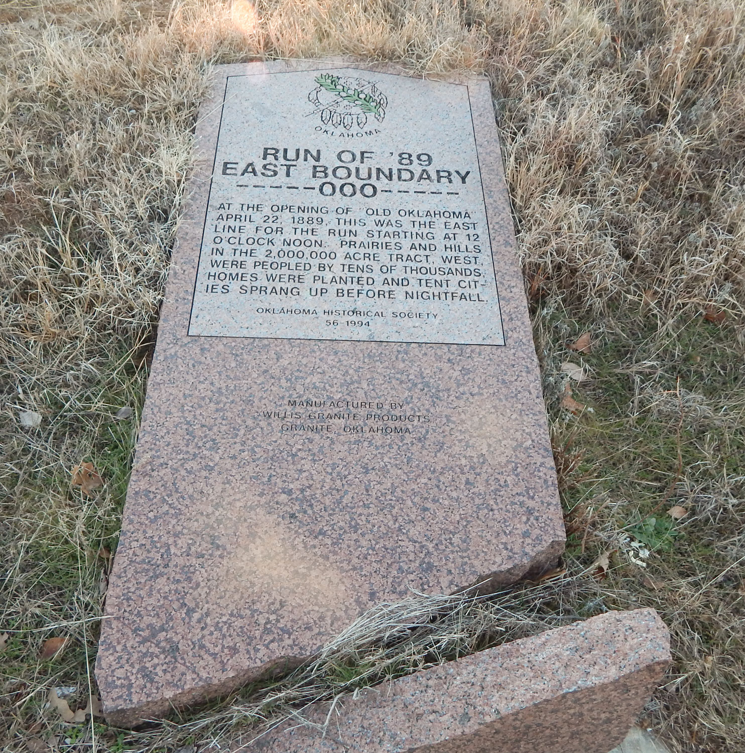
Location: on OK-66, four miles east of Arcadia
Topics: American Indians, Government
The eastern boundary of the Unassigned Lands was the western border of the Iowa, Sac and Fox, Kickapoo, Pottawatomi, and Absentee Shawnee reservations.
Location: 1 1/2 miles north of North Council Road and Northwest 234th Street in Oklahoma City
Topics: Religion/Philosophy, Territorial Period 1861–1907
As a mission of St. John the Baptist Catholic Church in Edmond, St. Patrick was reportedly the first rural church of any denomination to be built in the Unassigned Lands following the Run of 1889, with the cornerstone being placed in 1891. Known by several names over the years (Kerry Patch, Deer Creek, and Lockridge), the church was abandoned in the 1930s and no longer stands.
Location: 50 Broadway Circle, Oklahoma City
Sponsored by: Goldring/Woldenberg Institute of Southern Jewish Life; Jewish American Society for Historical Preservation.
Topics: Ethnic Diversity, Territorial Period 1861–1907, Religion/Philosophy
Jews have lived in Oklahoma since the mid-nineteenth century. In 1903, Jews in Oklahoma City organized Temple B'Nai Israel. During its first few years, the congregation met at several local churches. The synagogue, located at 50 Broadway Circle, was dedicated on January 17, 1908. Temple B'Nai Israel remained in this building until 1955, when they moved to a new synagogue on North Pennsylvania Street. Temple B'Nai Israel affirmed the American principals of freedom of religion and assembly in Oklahoma.
Location: at Oklahoma City Zoo
Material: Granite
Topics: Recreational/Service, Government, Early Statehood 1907–1941, Social/Cultural
This park was created between 1933 and 1936 by members of Civilian Conservation Corps No. 875 and 895. These companies were two of many such companies organized by the federal government during the Great Depression to provide useful employment for thousands of young men and to develop and save the nation's natural resources.
Location: on Avenue D, west of building 1, TAFB
Topics: Military, Industrial Period 1841–1892, Government
Established in March 1942 as the Oklahoma City Air Depot for the maintenance and repair of B-17, B-24, and B-29 bombers and named for Oklahoma Native Major General Clarence L. Tinker in October 1942. The base has provided important logistical support for the US war efforts in Korea, Vietnam and the Middle East.
Location: in Campbell Park
Sponsored by: Oklahoma City Community Foundation
Topics: Military, Early Statehood 1907–1941, Government
Commissioned in 1916, the USS Oklahoma was revered as one of the great naval vessels of the times. The USS Oklahoma had the distinction of being the first ship in the history of the US Navy to be christened for peace and not for war. After seeing limited action toward the end of World War I, the USS Oklahoma escorted President Woodrow Wilson on his voyages to France for the peace negotiations.
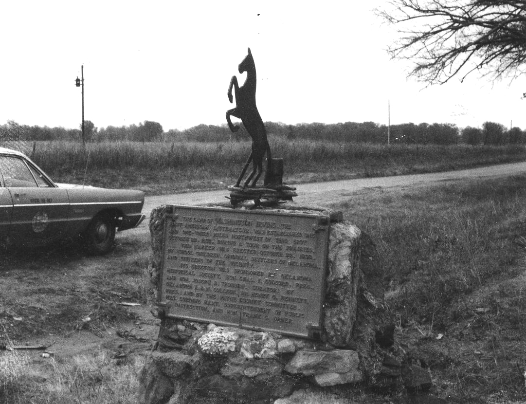
Location: on OK-66 in Arcadia
Material: Aluminum
Topics: Arts, Westward Expansion 1803–1861, Folklife
Washington Irving camped in this area in October 1832. During his tour of the prairies, Irving and his fellow explorers hunted wild horses. His description of the hunt filled a chapter of his classic, A Tour on the Prairies.
Location: in Memorial Park Cemetery at Memorial Road and Broadway Extension in Oklahoma City
Material: Granite
Topics: Recreational/Service, Social/Cultural, Industry/Business, Early Statehood 1907–1941
The "Father of Modern Aviation," Wiley Post, in 1933, was the first person to fly alone around the world. This self-taught scientist grew up in Oklahoma, discovered the jet stream, and invented the pressurized flying suit. Post's 1935 funeral was the largest in Oklahoma history; 75,000 people gathered.
Location: in Will Rogers Park, 3500 North Portland, Oklahoma City
Topics: Government, Social/Cultural, Recreational/Service, Early Statehood 1907–1941
Civilian Conservation Corps Companies 872, 875,and 895 built this vast city park during the Great Depression from 1933 to 1942. The young men planted trees and built roads and nurseries. The park is widely known for its flower gardens.
Le Flore County
Lincoln County
Logan County
Love County
Marshall County
Mayes County
McClain County
McCurtain County
McIntosh County
Murray County
Muskogee County
Noble County
Okfuskee County
Oklahoma County
Okmulgee County
Osage County
Ottawa County
Pawnee County
Payne County
Pittsburg County
Pontotoc County
Pottawatomie County
Pushmataha County
Roger Mills County
Rogers County
Seminole County
Sequoyah County
Stephens County
Texas County
Tillman County
Tulsa County
Wagoner County
Washington County
Washita County
Woods County
Woodward County
Historical Marker Program
Search Results
Your search returned 38 results.
American Mutual Company
Oklahoma CountyLocation: 1001 N. Pennsylvania Oklahoma City, OK
Material: Aluminum
Topics: Industry/Business, Retail, Social/Cultural, Urban Development
A pioneer of the warehouse club retail industry, AMC was established by the Homsey brothers and operated on this site from 1961 until 1987. The Homseys fought in court to give business owners the right to set their own prices without interference by producers, won in the Oklahoma Supreme Court on April 18, 1961, and thus changed Oklahoma's retail environment.
Andrew Solomon Layton
Oklahoma CountyLocation: on the grounds of the Wiley Post Building, 2100 North Lincoln Boulevard, Oklahoma City
Material: Granite
Topics: Social/Cultural, Urban Development, Early Statehood 1907–1941, Government, Education
Oklahoma's premier pioneer architect, Layton designed the State Capitol (1914), the Oklahoma Historical Society building (1930), and other early Oklahoma City structures, including the Mid-Continent Life Insurance Building. Statewide, Layton and his associates designed more than a hundred buildings, including thirty-two buildings at six colleges (plus at least one in Texas), twenty-one government buildings, and more than forty schools. He also designed residences in a number of communities and even a subdivision in Ponca City for the Marland Company.
Arcadia Historical Marker
Oklahoma CountyLocation: on State Highway 66 between Luther and Arcadia
Baptist Orphans' Home
Oklahoma CountyLocation: at the southeast corner of Northwest 63rd Street and Pennsylvania Avenue in Oklahoma City (OBHC)
Topics: Social/Cultural, Territorial Period 1861–1907, Education
In 1903, J. A. Scott founded an orphans' home here. The name was changed to the Oklahoma Baptist Children's Home in 1936. In 1983 the property was sold, and a new campus opened on South Western Avenue in Oklahoma City.
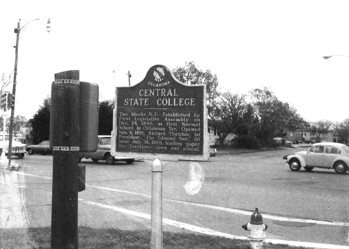
Central State College
Oklahoma CountyLocation: at Second Street and Boulevard in Edmond
Material: Aluminum
Topics: Education
The Oklahoma Territorial Legislature established the school for the training of teachers in December of 1890. Known as Central State Teachers College, Central State College, and Central State University, the institution is now the University of Central Oklahoma. Old North, built in 1892, is the oldest building on campus.
Civil War 10-Pounder
Oklahoma CountyLocation: on grounds of Wiley Post Building, 2100 North Lincoln Boulevard, Oklahoma City
Material: Aluminum
Topics: Military, Arts, Early Statehood 1907–1941
This three-inch, muzzle-loading field cannon was used in battle by the New Jersey Volunteer Artillery and for entertainment by Pawnee Bill's Wild West Show. Major Gordon W. Lillie (Pawnee Bill) gave the cannon to his long-time publicist Frank Stuart who kept it at his Nichols Hills home before bequeathing it to the Oklahoma Historical Society.
Columbia
Oklahoma CountyLocation: five miles east, at Lacey and Sheridan
Topics: Agriculture, Government, Mass Communication, Transportation, Settlement Patterns
Located five miles to the east in old Oklahoma Territory, this agricultural community was the site of a post office from February 21, 1890, to February 28, 1913. Named for a local merchant, Columbus Fash, the town disappeared after being bypassed by the railroad.
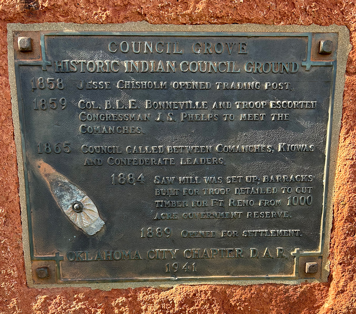
Council Grove
Oklahoma CountyLocation: near Northwest Tenth Street and the North Canadian River in Bethany (DAR)
Coordinates: 35.479047, -97.663289
Sponsored by: Daughters of the American Revolution
Topics: American Indians, Indian and Frontier Trade, Westward Expansion 1803–1861, Military
Jesse Chisholm opened a trading post here in 1858. In 1865, Comanche and Kiowa met nearby with Confederate leaders. Barracks were constructed on the site to house soldiers to clear timber for the construction of Fort Reno.
Council Grove School
Oklahoma CountyLocation: on West Reno Avenue in Oklahoma City
Material: Granite
Topics: Education, Territorial Period 1861–1907, Early Statehood 1907–1941, Mass Communication, Government
This was one of the first schools in Oklahoma County. It was later moved by wagon to the corner of Melrose Lane and Council Road. A second building was constructed in 1900 and the present red brick structure was completed in 1938. A post office was established at Council Grove on June 11, 1892. Two years later, the post office became Council but closed in 1906.
Delmar Garden
Oklahoma CountyLocation: on West Reno Avenue and South Western Avenue near the Oklahoma River in Oklahoma City
Material: Granite
Topics: Recreational/Service, Social/Cultural, Folklife, Territorial Period 1861–1907, Early Statehood 1907–1941
Once reportedly the largest amusement park west of the Mississippi River, Delmar Garden occupied 140 acres along the North Canadian River. The magnificent park, which boasted an outdoor theater, beer garden, dance hall, swimming pool, baseball park, and race track, opened barely a dozen years after Oklahoma City was carved out of a prairie. The park operated from 1902 to 1910 when a mosquito epidemic caused by high water closed the park. Apache Chief Geronimo once signed autographs here.
Edmond Station, Indian Territory
Oklahoma CountyLocation: on Broadway North of 2nd Street, Edmond
Material: Granite
Topics: Transportation
The Atchison, Topeka, and Santa Fe Railroad gave birth to Edmond, Oklahoma, in terms of location and name on April 22, 1889. During road construction it was known as Mile 103 or "Summit," a side stop on a high point (elev. 1198 feet) of the railway grade between the Cimarron and the North Canadian Rivers. On March 28, 1887, the stop was officially named "Edmond Station" for Edmond Burdick, the Santa Fe's traveling freight agent, and full train service began in June. The AT&SF's first coaling barn for the Unassigned Lands was located here. John N. Steen, the first permanent resident, completed the water well for the steam locomotives in May of 1888. The conical-covered well, pump house, water tower, depot, telegraph and express office that were along the railroad right-of-way from Third Street to north of west Second and the coaling barn near Fifth were "Edmond" before the land run. The name was retained by the '89ers who established the town around the station.
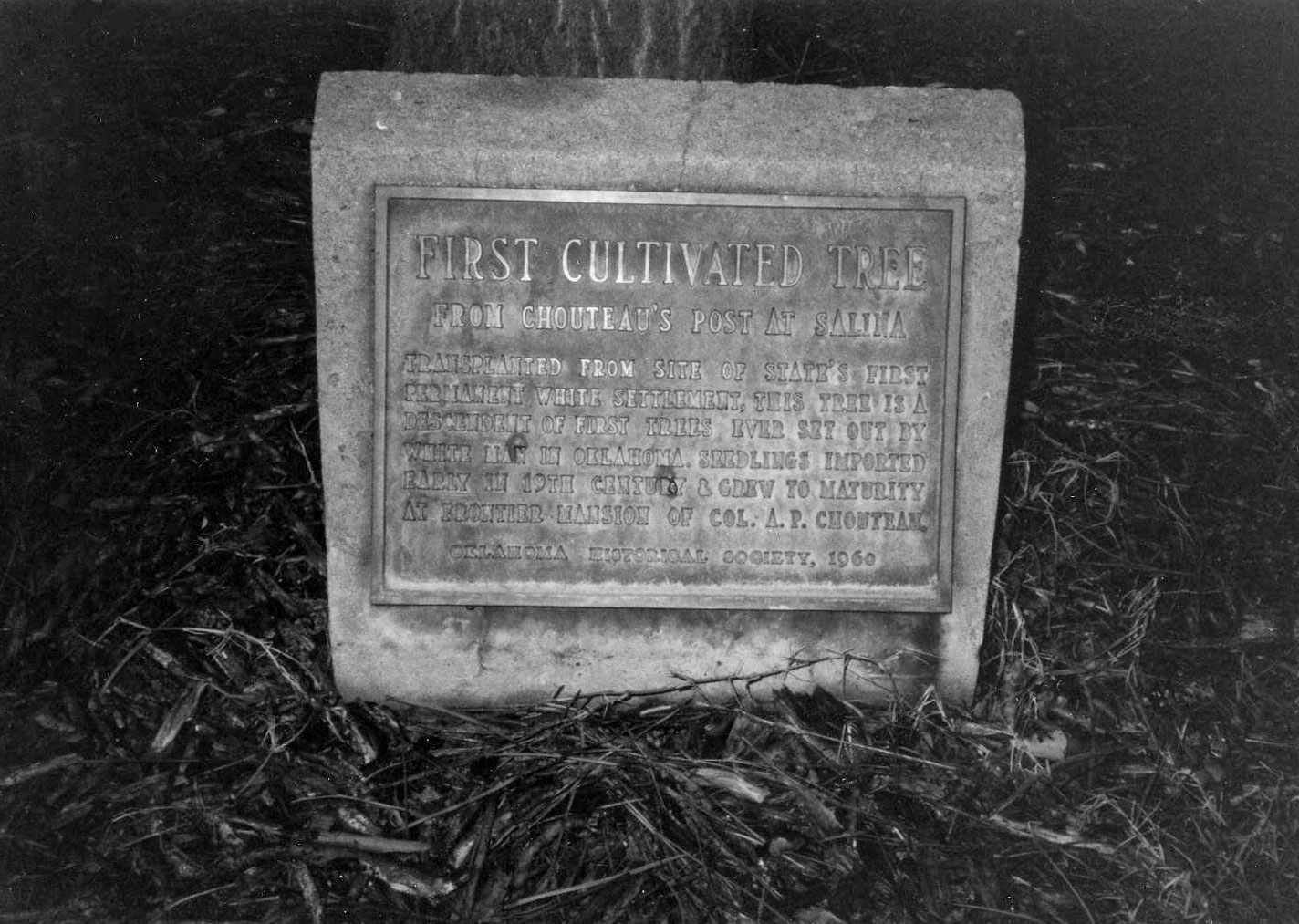
First Cultivated Tree
Oklahoma CountyLocation: Oklahoma Historical Society grounds
Topics: Timber, Folklife, Social/Cultural
Transplanted from Colonel A. P. Chouteau's post at Salina, Oklahoma's first permanent settlement, this tree is a descendant of the first trees planted in present-day Oklahoma by Chouteau in the early nineteenth century.
First Public Schoolhouse
Oklahoma CountyLocation: southwest corner of Second and Boulevard in Edmond
Sponsored by: Edmond Historical Preservation Trust (City of Edmond)
Topics: Education, Social/Cultural
One of the first recognized official Oklahoma Centennial Projects was the preservation of Oklahoma Territory's first public schoolhouse, located in Edmond.
First Tornado Forecast
Oklahoma CountyLocation: on Tinker Air Force Base
Topics: Military, Industrial Period 1841–1892, Natural Resources
On March 25, 1948, two Tinker Air Force Base officers issued the first tornado forecast several hours before a tornado struck the base. Major Ernest J. Fawbush and Captain Robert C. Miller developed tornado forecasting techniques still in use today. Their work brought national attention to warning the public of potential danger of severe weather.
Harrah
Oklahoma CountyLocation: on East Main Street at Museum
Sponsored by: Harrah Historical Society
Topics: American Indians, Westward Expansion 1803–1861, Transportation, Settlement Patterns, Territorial Period 1861–1907, Urban Development
The present site of Harrah was first settled in 1876 by French-Potawatomi Indian, Louis Navarre. In 1892, E. W. Sweeney built a bridge at a strategic ford across the North Canadian River, increasing the settlement's prospects. The railroad's arrival in 1896 assured success. Entrepreneur, Frank Harrah, purchased eighty acres from Navarre of which a portion was used for development. A forty-acre tract was surveyed, platted, and officially entered as the town of Harrah on February 18, 1899. This marker stands within the original tract in the heart of the town's early business district.
Joseph Bradfield Thoburn
Oklahoma CountyLocation: in Rose Hill Cemetery, Oklahoma City
Material: Granite
Topics: Social/Cultural, Government, Territorial Period 1861–1907, Early Statehood 1907–1941
Joseph Thoburn (1866–1941), Oklahoma's pioneer historian, was born in Bellaire, Ohio, and reared and educated in Kansas. Thoburn was secretary of the Oklahoma Commercial Club and the Oklahoma Territorial Board of Agriculture. He was the director of the Oklahoma Historical Society for thirty-eight years and admitted to the Oklahoma Hall of Fame in 1932. He was also active in religious, educational, and civic works.
Kicking Bird
Oklahoma CountyLocation: in Gracelawn Cemetery in Edmond
Material: Granite
Topics: Mass Communication, Land Openings, Settlement Patterns, Folklife, Government, Territorial Period 1861–1907
Publisher and founder of the Edmond Sun, Milton W. "Kicking Bird" Reynolds was a nationally known newspaperman who promoted opening the Unassigned Lands in the 1880s. He made the Land Run of 1889 by train and is credited as being the first to call Oklahoma "Land of the Fair God." He was a member of Oklahoma's first territorial legislature. He died in 1890.
King Charles II Charter
Oklahoma CountyLocation: Oklahoma Historical Society grounds
Material: Granite
Topics: Empire Period 1541–1803, Government, Settlement Patterns
The charter of 1663 granted a large section of land from the east coast to the west coast to eight Lords Proprietors and supporters of Charles II. Much of present-day Oklahoma is included in the proposed boundaries of this charter.
Kunc Family Homestead/Bradbury Corner Historical Marker
Oklahoma CountyLocation: on Second Street at the entrance to Holiday Inn Express
Topics: Settlement Patterns, Land Openings, Agriculture, Industry/Business, Transportation, Early Statehood 1907–1941
James and Katherine Kunc and son, William, made the run and homesteaded a quarter section on the southwest corner of Second and Sooner on April 22, 1889. In 1923, Everett Bradbury purchased one acre of land on the northeast corner of the homestead and established a campground and filling station. This intersection was the junction of US Highway 66 and US Highway 77 and became known as Bradbury Corner.
Liberty Bell Replica
Oklahoma CountyLocation: on the grounds of the Oklahoma History Center, 800 Nazih Zuhdi Drive, Oklahoma City
Material: Granite
Topics: Government, Social/Cultural, Industrial Period 1841–1892
For the 1950 US Independence Savings Bond Drive, the government ordered one Liberty Bell replica for each state. Cast in France, this bell was transported around the state on a flatbed truck to promote the sale of savings bonds. It was originally located at the Wiley Post building in Oklahoma City, and was later moved to the Oklahoma History Center grounds.
Oklahoma City DAR Chapter
Oklahoma CountyLocation: at 212 Northwest 15th Street in Oklahoma City (DAR)
Sponsored by: Daughters of the American Revolution
Topics: Recreational/Service, Social/Cultural, Folklife
The Oklahoma City Chapter of the Daughters of the American Revolution was organized in 1904 in the home of Mrs. Robert Carpenter.
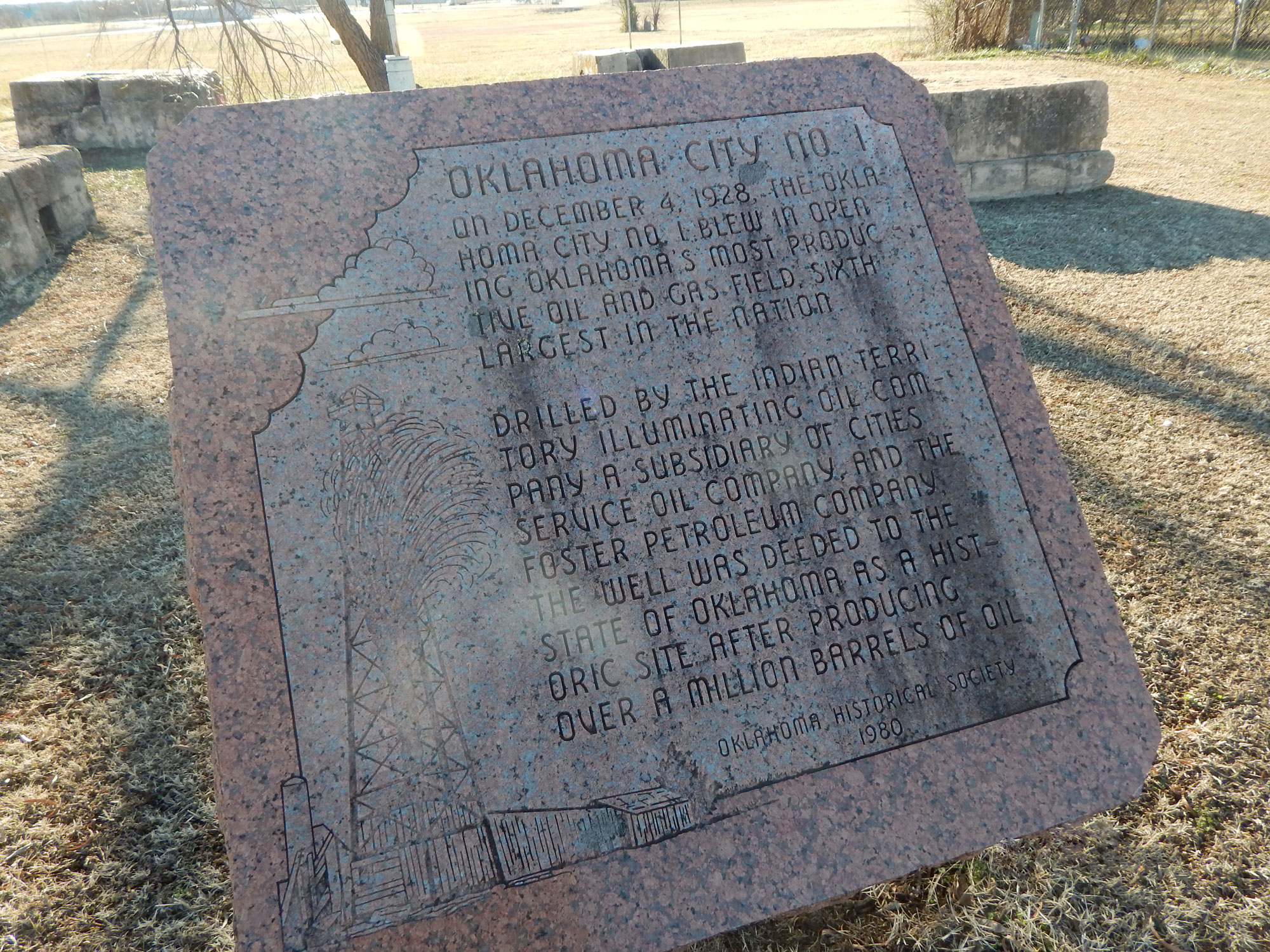
Oklahoma City No. 1
Oklahoma CountyLocation: near the intersection of Southeast 59th and Bryant
Material: Granite
Topics: Petroleum, Natural Resources, Industry/Business, Early Statehood 1907–1941
On December 4, 1928, the Oklahoma City No. 1 blew, opening Oklahoma's most productive oil and gas field and the sixth largest in the nation. It was drilled by the Indian Territory Illuminating Oil Company, a subsidiary of Cities Service Oil Company and the Foster Petroleum Company. The well was deeded to the State of Oklahoma as a historic site after producing over a million barrels of oil.
Oklahoma City Oil Field
Oklahoma CountyLocation: northeast corner of the Flag Plaza at State Capitol
Material: Granite
Topics: Petroleum, Natural Resources, Industry/Business, Early Statehood 1907–1941
The discovery of the famous Oklahoma City Oil Field was made by H. V. Foster, president of the Indian Territory Illuminating Oil Company, on December 4, 1928, when Oklahoma City No. 1 began production. Located at Southeast 57th Street and Indian Territory Illuminating Oil Company Boulevard, this well marked the beginning of a great rush for "black gold" in the area. The site is now under the control of the Oklahoma Historical Society.
Oklahoma City Zoo
Oklahoma CountyLocation: at Oklahoma City Zoo, NE 50th and Eastern in Oklahoma City
Material: Granite
Topics: Recreational/Service, Social/Cultural, Territorial Period 1861–1907
First in the southwest, the Oklahoma City Zoo was established in Wheeler Park in 1904. It was destroyed by the flood of 1923. It was then moved to Lincoln Park.
Oklahoma Historical Society Museum
Oklahoma CountyLocation: at 800 Nazih Zudhi Drive, Oklahoma City
Topics: Recreational/Service, Social/Cultural, Early Statehood 1907–1941, Government
Containing one of the finer collections of Indian artifacts in the United States, this museum is the headquarters of the Oklahoma Historical Society. It portrays all aspects of Oklahoma's heritage, from its prehistoric Indian culture exhibits to its "Oklahoma in Space" display.
Overholser Mansion
Oklahoma CountyLocation: at the Henry and Anna Overholser Mansion, 405 Northwest 15th Street in Oklahoma City
Material: Granite
Topics: Urban Development, Land Openings, Settlement Patterns, Arts, Family/Household, Transportation
Henry Overholser arrived in Oklahoma as an '89er and soon became a prominent civic leader. He worked tirelessly to bring several railroads to Oklahoma City and operated the Overholser Opera House for many years. He constructed this Victorian mansion in 1904. It became a showplace and the center of the city's social and cultural life.
Payne Campsite
Oklahoma CountyLocation: near intersection of Stanton L. Young and Lindsey in Oklahoma City (DAR)
Sponsored by: Daughters of the American Revolution
Topics: Transportation, Water, Land Openings
A nearby spring provided water for cattlemen and Indians prior to settlement. The campground was a favorite of Captain David L. Payne, the early leader of the Boomer movement for opening the Unassigned Lands.
Robberson Steel Company
Oklahoma CountyLocation: at 1401 NW 3rd Street, Oklahoma City
Topics: Manufacturing
On this site in 1936 R. W. Robberson located the Robberson Steel Company, opening a new industrial area in Oklahoma City. Beginning his career in 1913 with John Kline, 110 N. Francis, he acquired ownership in 1928. His foresight and initiative have for sixty-four years contributed to the industrial growth and progress of Oklahoma.
Route 66
Oklahoma CountyLocation: on Route 66 in Arcadia, across from Round Barn
Material: Granite
Topics: Transportation
Whether motorists called Route 66 the Ozark Trail, the Will Rogers Highway, Main Street America or the Mother Road, all remember Arcadia's Round Barn. The well-known landmark was built in 1898 by W. H. Odor. After the route was designated a national highway in 1926, improvements were made to the 1917 roadbed. The original road between Edmond and Arcadia was constructed by convict labor. The highway through Arcadia was paved in 1929. Many Arcadia businesses catered to travelers' needs with gasoline stations, cafes, lodging facilities and a grocery and general store.
Run of '89 East Boundary
Oklahoma CountyLocation: on OK-66, four miles east of Arcadia
Topics: American Indians, Government
The eastern boundary of the Unassigned Lands was the western border of the Iowa, Sac and Fox, Kickapoo, Pottawatomi, and Absentee Shawnee reservations.
Saint Patrick's Church
Oklahoma CountyLocation: 1 1/2 miles north of North Council Road and Northwest 234th Street in Oklahoma City
Topics: Religion/Philosophy, Territorial Period 1861–1907
As a mission of St. John the Baptist Catholic Church in Edmond, St. Patrick was reportedly the first rural church of any denomination to be built in the Unassigned Lands following the Run of 1889, with the cornerstone being placed in 1891. Known by several names over the years (Kerry Patch, Deer Creek, and Lockridge), the church was abandoned in the 1930s and no longer stands.
Temple B'Nai Israel
Oklahoma CountyLocation: 50 Broadway Circle, Oklahoma City
Sponsored by: Goldring/Woldenberg Institute of Southern Jewish Life; Jewish American Society for Historical Preservation.
Topics: Ethnic Diversity, Territorial Period 1861–1907, Religion/Philosophy
Jews have lived in Oklahoma since the mid-nineteenth century. In 1903, Jews in Oklahoma City organized Temple B'Nai Israel. During its first few years, the congregation met at several local churches. The synagogue, located at 50 Broadway Circle, was dedicated on January 17, 1908. Temple B'Nai Israel remained in this building until 1955, when they moved to a new synagogue on North Pennsylvania Street. Temple B'Nai Israel affirmed the American principals of freedom of religion and assembly in Oklahoma.
The CCC and OKC Zoological Park and Amphitheater
Oklahoma CountyLocation: at Oklahoma City Zoo
Material: Granite
Topics: Recreational/Service, Government, Early Statehood 1907–1941, Social/Cultural
This park was created between 1933 and 1936 by members of Civilian Conservation Corps No. 875 and 895. These companies were two of many such companies organized by the federal government during the Great Depression to provide useful employment for thousands of young men and to develop and save the nation's natural resources.
Tinker Air Force Base
Oklahoma CountyLocation: on Avenue D, west of building 1, TAFB
Topics: Military, Industrial Period 1841–1892, Government
Established in March 1942 as the Oklahoma City Air Depot for the maintenance and repair of B-17, B-24, and B-29 bombers and named for Oklahoma Native Major General Clarence L. Tinker in October 1942. The base has provided important logistical support for the US war efforts in Korea, Vietnam and the Middle East.
USS Oklahoma Anchor
Oklahoma CountyLocation: in Campbell Park
Sponsored by: Oklahoma City Community Foundation
Topics: Military, Early Statehood 1907–1941, Government
Commissioned in 1916, the USS Oklahoma was revered as one of the great naval vessels of the times. The USS Oklahoma had the distinction of being the first ship in the history of the US Navy to be christened for peace and not for war. After seeing limited action toward the end of World War I, the USS Oklahoma escorted President Woodrow Wilson on his voyages to France for the peace negotiations.
Washington Irving's Camp
Oklahoma CountyLocation: on OK-66 in Arcadia
Material: Aluminum
Topics: Arts, Westward Expansion 1803–1861, Folklife
Washington Irving camped in this area in October 1832. During his tour of the prairies, Irving and his fellow explorers hunted wild horses. His description of the hunt filled a chapter of his classic, A Tour on the Prairies.
Wiley Post Monument
Oklahoma CountyLocation: in Memorial Park Cemetery at Memorial Road and Broadway Extension in Oklahoma City
Material: Granite
Topics: Recreational/Service, Social/Cultural, Industry/Business, Early Statehood 1907–1941
The "Father of Modern Aviation," Wiley Post, in 1933, was the first person to fly alone around the world. This self-taught scientist grew up in Oklahoma, discovered the jet stream, and invented the pressurized flying suit. Post's 1935 funeral was the largest in Oklahoma history; 75,000 people gathered.
Will Rogers Park
Oklahoma CountyLocation: in Will Rogers Park, 3500 North Portland, Oklahoma City
Topics: Government, Social/Cultural, Recreational/Service, Early Statehood 1907–1941
Civilian Conservation Corps Companies 872, 875,and 895 built this vast city park during the Great Depression from 1933 to 1942. The young men planted trees and built roads and nurseries. The park is widely known for its flower gardens.
(Page 1 of 1)
Search for Markers
Search by keyword or browse by county to learn about more than 600 historical markers created to recognize key locations, events, and people in Oklahoma history.
Please note that some markers listed in this database may have been moved, damaged, or are no longer standing.
Browse by County
Adair County
Alfalfa County
Atoka County
Beaver County
Beckham County
Blaine County
Bryan County
Caddo County
Canadian County
Carter County
Cherokee County
Choctaw County
Cimarron County
Cleveland County
Comanche County
Cotton County
Craig County
Creek County
Custer County
Delaware County
Dewey County
Ellis County
Garfield County
Garvin County
Grady County
Grant County
Greer County
Harmon County
Harper County
Haskell County
Hughes County
Jackson County
Jefferson County
Johnston County
Kay County
Kingfisher County
Kiowa County
Latimer CountyAlfalfa County
Atoka County
Beaver County
Beckham County
Blaine County
Bryan County
Caddo County
Canadian County
Carter County
Cherokee County
Choctaw County
Cimarron County
Cleveland County
Comanche County
Cotton County
Craig County
Creek County
Custer County
Delaware County
Dewey County
Ellis County
Garfield County
Garvin County
Grady County
Grant County
Greer County
Harmon County
Harper County
Haskell County
Hughes County
Jackson County
Jefferson County
Johnston County
Kay County
Kingfisher County
Kiowa County
Le Flore County
Lincoln County
Logan County
Love County
Marshall County
Mayes County
McClain County
McCurtain County
McIntosh County
Murray County
Muskogee County
Noble County
Okfuskee County
Oklahoma County
Okmulgee County
Osage County
Ottawa County
Pawnee County
Payne County
Pittsburg County
Pontotoc County
Pottawatomie County
Pushmataha County
Roger Mills County
Rogers County
Seminole County
Sequoyah County
Stephens County
Texas County
Tillman County
Tulsa County
Wagoner County
Washington County
Washita County
Woods County
Woodward County
Contact Us
If you have questions, please contact:
Matthew Pearce
Oklahoma Historical Society
800 Nazih Zuhdi Drive
Oklahoma City, OK 73105
405-522-8659
matthew.pearce@history.ok.gov