
Home | About OHS | Historical Marker Program
Location: in community of Brooksville
Topics: Ethnic Diversity, Urban Development, Territorial Period 1861–1907, Early Statehood 1907–1941, Settlement Patterns, Land Openings
Brooksville is one of thirteen All-Black towns, out of more than fifty that once existed, remaining in Oklahoma. While Tullahassee is reportedly the oldest, most were established between 1889 and 1907 as African Americans sought security and control of their own destiny in a segregated world. Most of the towns began to decline in the 1920s and 1930s as rural African Americans faced economic hardships and began to move to urban areas. Brooksville had a post office from 1909 to 1955 and is named for the first postmaster, Alfred H. Brooks.
Location: at 103 North Main Street, Miami
Topics: Arts, Early Statehood 1907–1941
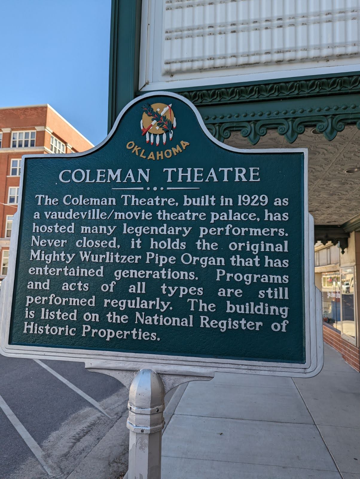
The Coleman Theatre, built in 1929 as a vaudeville/movie theatre palace, has hosted many legendary performers. Never closed, it holds the original Mighty Wurlitzer Pipe Organ that has entertained generations. Programs and acts of all types are still performed regularly.
Location: on US-69 Alternate just south of Kansas-Oklahoma border
Topics: American Indians, Settlement Patterns, Westward Expansion 1803–1861
This area was granted to the Quapaw tribe in 1833. Nearby, members of twenty other tribes received lands from the federal government.
Location: on Main Street (Route 66) south of downtown Miami
Coordinates: 36.871467, -94.877467
Material: Aluminum
Note: UD,TN,ES
Topics: Urban Development, Transportation, Early Statehood 1907-1941
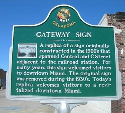
A replica of a sign originally constructed in the 1900's that spanned Central and C Street adjacent to the railroad station. For many years this sign welcomed visitors to downtown Miami. The original sign was removed during the 1930's. Today's replica welcomes visitors to a revitalized downtown Miami.
Location: off Hwy. 69-one mile north of Narcissa, 1/2 mile after the water tower, turn right
Topics: Transportation
Location: on OK-18 in Fairview Cemetery in Shawnee
Coordinates: 35.343130, -96.911991
Sponsored by: Oklahoma Historical Society/Oklahoma Department of Transportation
Material: Aluminum
Topics: Arts, Social/Cultural, Territorial Period 1861–1907, Early Statehood 1907–1941
Dr. Brewster Higley died in Shawnee in 1911, several years before his song, "Home on the Range," was declared an American frontier ballad. The words to the song were first printed in a newspaper in 1873. Dr. Higley never saw a printed copy of the song or received a penny's royalty.
Location: On OK-39, two miles east of Asher
Coordinates: 34.985850, -96.887380
Sponsored by: Carrie Boggs and Pottawatomie County Historical Society
Material: Stone
Topics: Westward Expansion 1803–1861, American Indians, American Indian and Frontier Trade
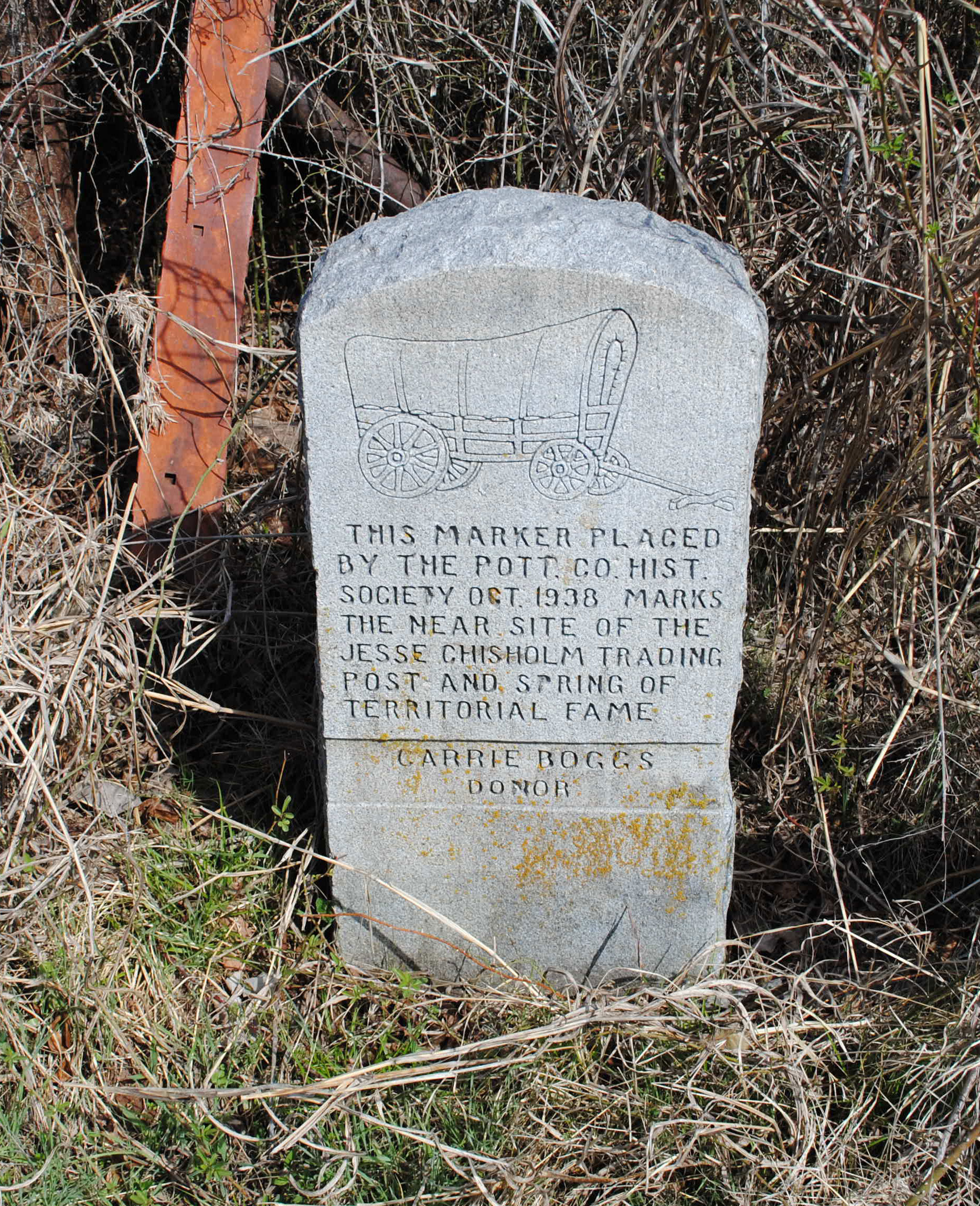
This marker placed by the Pottawatomie County Historical Society Oct. 1938 marks the near site of the Jesse Chisholm Trading Post and Spring of territorial fame.
Location: approx. 6 miles southwest of Prague and approx. 5 miles south of US 62 on NS Rd 3510
Coordinates: 35.421941, -96.753523
Sponsored by: BancFirst of Prague and the Oklahoma Historical Society
Material: Granite
Topics: American Indians, Social/Cultural, Recreational/Service, Early Statehood 1907–1941
James Francis Thorpe, a Sac and Fox, was born as Wa-tho-huck or "bright path." He dominated the 1912 Olympics, winning both the decathlon and pentathlon events. He played major league baseball and professional football. He was the first president of the National Football League and is a member of Professional Football Hall of Fame. The Associated Press voted him the world's greatest male athlete of the first half of the twentieth century.

Location: on OK-99 north of North Canadian River
Note: Marker reported missing
Topics: American Indians, Territorial Period 1861–1907, Settlement Patterns, Urban Development, Social/Cultural
After the land run into the Sac and Fox Reservation on September 22, 1891, the Keokuk Falls town site became an important settlement in Indian Territory. The boomtown boasted two distilleries and many saloons.
Location: on Hy 177 north of Shawnee and Tecumseh
Note: Presumed missing
Topics: Military, Recreational/Service, Industry/Business, Industrial Period 1841–1892
Leroy Cooper was one of the first seven American astronauts named in 1959. He flew one of the early missions into space aboard Faith 7 in 1963. His 22 orbits around the earth became the longest space flight at that time in history. Cooper died in 2004.
Location: on grounds of Pottawatomie County Museum on East Main Street in Shawnee
Coordinates: 35.327583, -96.916033
Sponsored by: Wunagisa Chapter Daughters of the American Revolution
Material: Granite
Topics: Arts, Government, Social/Cultural, Recreational/Service, Folklife
Louise Funk Fluke (1900–1986), designer of the State Flag of Oklahoma, was born in Arkansas and raised in Shawnee. She entered the winning flag design in a statewide contest in 1925 through the Wunagisa Chapter, Daughters of the American Revolution. She is buried at Fairview Cemetery.
Location: 1/4 mile south of Hwy 10C in Ottawa
Topics: American Indians, Settlement Patterns, Social/Cultural, Government
All that remains of the original 4,000-acre Modoc Reservation is this 4 1/2 acre cemetery, the final resting place of Scarfaced Charley, Shacknasty Jim, James Long, Long George, and other leaders of California's Modoc War. Fought over 100 years ago in lava beds near Tulelake, California, this full-scale military campaign against "Captain Jack" and his band is famous in annals of Indian Wars. Today, the rolls of the vanishing Modoc contain only fifty-two descendants of those who peacefully exiled to the Quapaw Agency as prisoners-of-war in November 1873.
Location: near intersection of Central and Main Streets, Miami
Topics: Transportation, Social/Cultural, Early Statehood 1907–1941
The Ozark Trails Movement, founded in 1913, played an early role promoting east-west highways and the future US 66 in Oklahoma, Texas, and New Mexico. This obelisk was originally located in the intersection of Main and Central Street. It was constructed in 1920 and removed in the late 1920s as a traffic hazard.
Location: 1 1/2 mile south of Picher at Junction 69 north and 66 east and west
Topics: Mining, Early Statehood 1907–1941, Industrial Period 1841–1892, Military
From 1917 to 1967 Picher Mining Field yielded 450 million tons of ore, 21 million tons of concentrate, 11 million tons of metal; from 1921 to 1946, it was known as the world's largest and richest lead and zinc field. Picher Mining Field and people who worked here produced key materials for World Wars I and II and the Korean Conflict.
Location: on OK-39, six miles east of Asher
Sponsored by: Oklahoma Historical Society and the Oklahoma Department of Transportation
Material: Aluminum
Note: No longer extant
Topics: American Indians, Religion/Philosophy, Education, Territorial Period 1861–1907
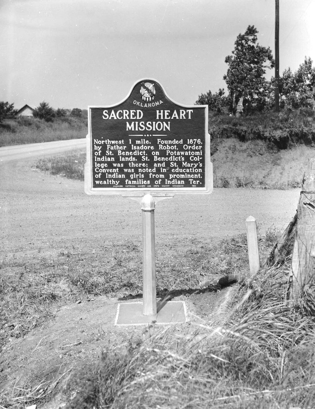
Founded in 1876 by Father Isidore Robot on Potawatomi Indian lands, the mission served both the educational and spiritual needs of the Native Americans in the region. The educational work was eventually transferred to St. Gregory's College in Shawnee.
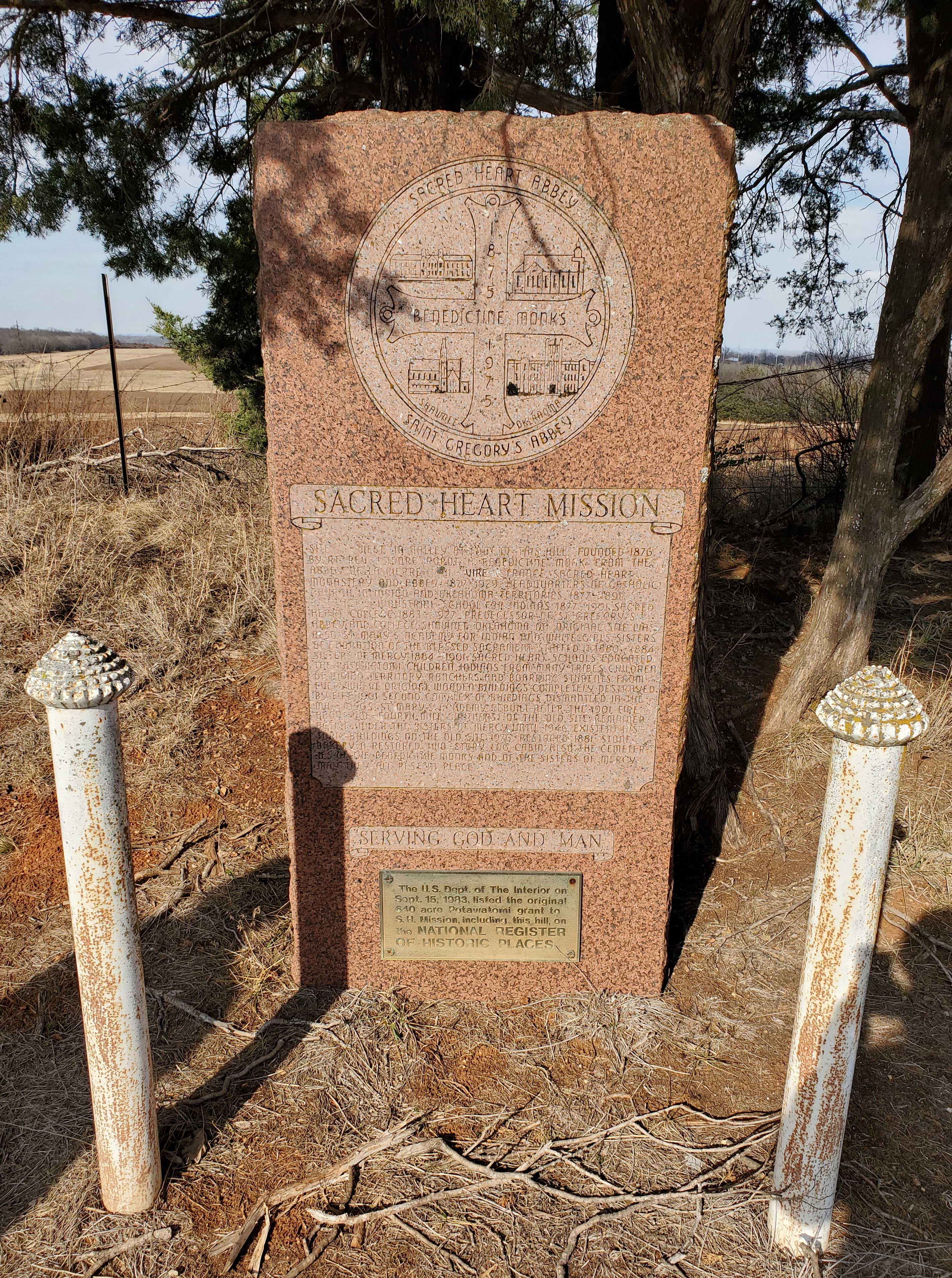
Location: at Sacred Heart Catholic Church, six miles east of Asher
Coordinates: 34.999126, -96.810716
Material: Granite
Topics: American Indians, Religion/Philosophy, Education, Territorial Period 1861–1907, Early Statehood 1907–1941
Site west in valley at foot of this hill founded 1876 by Rt. Rev. Isidore Robot, a Benedictine monk from the abbey of La Pierre. Sacred Heart Monastery and Abbey, 1877-1929. Headquarters of Catholic Church in Indian and Oklahoma territories, 1877-1891. St. Benedict Industrial School for Indians, 1877-1901. Sacred Heart College 1883-1927. Predecessor of St. Gregory's Abbey and College, Shawnee, Oklahoma.
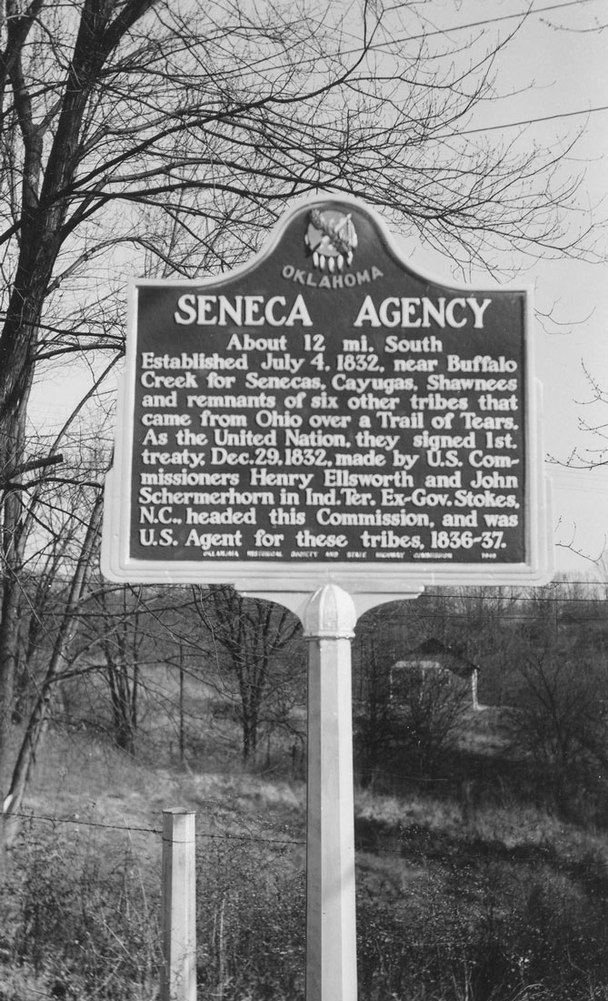
Location: on US-60 near Missouri border west of Seneca, Missouri
Material: Aluminum
Note: Marker reported missing
Topics: American Indians, Government, Settlement Patterns, Westward Expansion 1803–1861
The federal government established this agency in 1832 for the Seneca and remnants of seven other tribes who had been relocated in Indian Territory from Ohio.
Location: two miles south of Shawnee on OK-18 near old Shawnee Friends Mission Church
Coordinates: 35.293700, -96.925967
Sponsored by: Shawnee Milling Company and the Oklahoma Historical Society
Material: Aluminum
Topics: Industry/Business, Territorial Period 1861–1907, Early Statehood 1907–1941, Agriculture
Founded in 1891, the mill moved to its present site at 201 South Broadway in 1895. J. Lloyd Ford purchased the mill in 1906 and was a leader in flour milling in the state for a half century. The mill burned in 1934 but was rebuilt the following year.
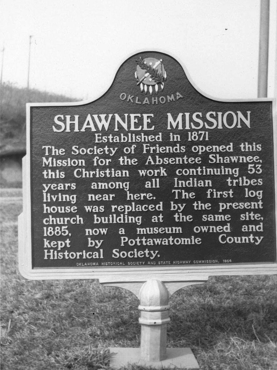
Location: two miles south of Shawnee on OK-18 near old Shawnee Friends Mission Church
Coordinates: 35.293700, -96.925967
Sponsored by: Oklahoma Historical Society and the Oklahoma Department of Transportation
Material: Aluminum
Topics: Religion/Philosophy, Education, American Indians
The Society of Friends founded this mission in 1871 for the Absentee Shawnee Indians. The original log cabin was replaced in 1885. The school closed in 1924 but the property was transferred to the Pottawatomie County Historical Society in 1936.
Location: on campus of Oklahoma Baptist University in Shawnee (OBHC)
Sponsored by: Baptist General Convention of Oklahoma
Material: Aluminum
Note: Destroyed by tornado and removed (2023)
Topics: Religion/Philosophy, Territorial Period 1861–1907, Early Statehood 1907–1941
Cortez Stubblefield (1848–1930) was a Baptist pastor and denominational statesman. The building, originally located at 207 North Union Avenue, was moved to its present location in 1963. The Baptist General Convention of Indian Territory, antecedent to the present Baptist General Convention of Oklahoma, held its final meeting in the building in 1906.
Location: GAR Cemetery, 129 5th Ave, Miami OK
Material: Aluminum
Topics: Military, Social/Cultural, Early Statehood 1907–1941
During WWII 1941-1945, the Spartan School of Aeronautics, British Flying Three was established in Miami, OK to train British Pilots without the rest of interference. Miami's roster included 2124 Royal Air Force cadet and 117 United cadets of which 1493 pilots were awarded RAF wings. 15 British cadets lost their lives in training and interred here. Each year in October, G.A.R, Cemetery holds an annual British Flyers Remembrance ceremony to honor the lives of these 15 British cadets and to educate the public, young and old, to continue their legacy. Lest we forget.
Location: on grounds of Santa Fe Museum on East Main Street in Shawnee (DAR)
Sponsored by: Daughters of the American Revolution
Topics: Arts, Westward Expansion 1803–1861
Writer Washington Irving camped near here on his tour of the prairies in 1832.
Location: on OK-137 in Twin Bridges State Park, .2 mile north of US-60
Material: Granite
Topics: American Indians, Westward Expansion 1803–1861, Government
The Wyandots moved from Kansas to the north side of the Seneca Reservation in Indian Territory in the 1850s but did not control their own affairs until passage of the Oklahoma Indian Welfare Act of 1936.
Le Flore County
Lincoln County
Logan County
Love County
Marshall County
Mayes County
McClain County
McCurtain County
McIntosh County
Murray County
Muskogee County
Noble County
Okfuskee County
Oklahoma County
Okmulgee County
Osage County
Ottawa County
Pawnee County
Payne County
Pittsburg County
Pontotoc County
Pottawatomie County
Pushmataha County
Roger Mills County
Rogers County
Seminole County
Sequoyah County
Stephens County
Texas County
Tillman County
Tulsa County
Wagoner County
Washington County
Washita County
Woods County
Woodward County
Historical Marker Program
Search Results
Your search returned 23 results.
Brooksville
Pottawatomie CountyLocation: in community of Brooksville
Topics: Ethnic Diversity, Urban Development, Territorial Period 1861–1907, Early Statehood 1907–1941, Settlement Patterns, Land Openings
Brooksville is one of thirteen All-Black towns, out of more than fifty that once existed, remaining in Oklahoma. While Tullahassee is reportedly the oldest, most were established between 1889 and 1907 as African Americans sought security and control of their own destiny in a segregated world. Most of the towns began to decline in the 1920s and 1930s as rural African Americans faced economic hardships and began to move to urban areas. Brooksville had a post office from 1909 to 1955 and is named for the first postmaster, Alfred H. Brooks.
Coleman Theatre
Ottawa CountyLocation: at 103 North Main Street, Miami
Topics: Arts, Early Statehood 1907–1941
The Coleman Theatre, built in 1929 as a vaudeville/movie theatre palace, has hosted many legendary performers. Never closed, it holds the original Mighty Wurlitzer Pipe Organ that has entertained generations. Programs and acts of all types are still performed regularly.
Entering Indian Territory
Ottawa CountyLocation: on US-69 Alternate just south of Kansas-Oklahoma border
Topics: American Indians, Settlement Patterns, Westward Expansion 1803–1861
This area was granted to the Quapaw tribe in 1833. Nearby, members of twenty other tribes received lands from the federal government.
Gateway Sign
Ottawa CountyLocation: on Main Street (Route 66) south of downtown Miami
Coordinates: 36.871467, -94.877467
Material: Aluminum
Note: UD,TN,ES
Topics: Urban Development, Transportation, Early Statehood 1907-1941
A replica of a sign originally constructed in the 1900's that spanned Central and C Street adjacent to the railroad station. For many years this sign welcomed visitors to downtown Miami. The original sign was removed during the 1930's. Today's replica welcomes visitors to a revitalized downtown Miami.
Historic Route 66 Highway Ribbon Road
Ottawa CountyLocation: off Hwy. 69-one mile north of Narcissa, 1/2 mile after the water tower, turn right
Topics: Transportation
Home on the Range
Pottawatomie CountyLocation: on OK-18 in Fairview Cemetery in Shawnee
Coordinates: 35.343130, -96.911991
Sponsored by: Oklahoma Historical Society/Oklahoma Department of Transportation
Material: Aluminum
Topics: Arts, Social/Cultural, Territorial Period 1861–1907, Early Statehood 1907–1941
Dr. Brewster Higley died in Shawnee in 1911, several years before his song, "Home on the Range," was declared an American frontier ballad. The words to the song were first printed in a newspaper in 1873. Dr. Higley never saw a printed copy of the song or received a penny's royalty.
Jesse Chisholm Trading Post and Spring
Pottawatomie CountyLocation: On OK-39, two miles east of Asher
Coordinates: 34.985850, -96.887380
Sponsored by: Carrie Boggs and Pottawatomie County Historical Society
Material: Stone
Topics: Westward Expansion 1803–1861, American Indians, American Indian and Frontier Trade
This marker placed by the Pottawatomie County Historical Society Oct. 1938 marks the near site of the Jesse Chisholm Trading Post and Spring of territorial fame.
Jim Thorpe Birthplace No. 2
Pottawatomie CountyLocation: approx. 6 miles southwest of Prague and approx. 5 miles south of US 62 on NS Rd 3510
Coordinates: 35.421941, -96.753523
Sponsored by: BancFirst of Prague and the Oklahoma Historical Society
Material: Granite
Topics: American Indians, Social/Cultural, Recreational/Service, Early Statehood 1907–1941
James Francis Thorpe, a Sac and Fox, was born as Wa-tho-huck or "bright path." He dominated the 1912 Olympics, winning both the decathlon and pentathlon events. He played major league baseball and professional football. He was the first president of the National Football League and is a member of Professional Football Hall of Fame. The Associated Press voted him the world's greatest male athlete of the first half of the twentieth century.
Keokuk Falls
Pottawatomie CountyLocation: on OK-99 north of North Canadian River
Note: Marker reported missing
Topics: American Indians, Territorial Period 1861–1907, Settlement Patterns, Urban Development, Social/Cultural
After the land run into the Sac and Fox Reservation on September 22, 1891, the Keokuk Falls town site became an important settlement in Indian Territory. The boomtown boasted two distilleries and many saloons.
Leroy Gordon Cooper
Pottawatomie CountyLocation: on Hy 177 north of Shawnee and Tecumseh
Note: Presumed missing
Topics: Military, Recreational/Service, Industry/Business, Industrial Period 1841–1892
Leroy Cooper was one of the first seven American astronauts named in 1959. He flew one of the early missions into space aboard Faith 7 in 1963. His 22 orbits around the earth became the longest space flight at that time in history. Cooper died in 2004.
Louise Fluke Memorial
Pottawatomie CountyLocation: on grounds of Pottawatomie County Museum on East Main Street in Shawnee
Coordinates: 35.327583, -96.916033
Sponsored by: Wunagisa Chapter Daughters of the American Revolution
Material: Granite
Topics: Arts, Government, Social/Cultural, Recreational/Service, Folklife
Louise Funk Fluke (1900–1986), designer of the State Flag of Oklahoma, was born in Arkansas and raised in Shawnee. She entered the winning flag design in a statewide contest in 1925 through the Wunagisa Chapter, Daughters of the American Revolution. She is buried at Fairview Cemetery.
Modoc Cemetery
Ottawa CountyLocation: 1/4 mile south of Hwy 10C in Ottawa
Topics: American Indians, Settlement Patterns, Social/Cultural, Government
All that remains of the original 4,000-acre Modoc Reservation is this 4 1/2 acre cemetery, the final resting place of Scarfaced Charley, Shacknasty Jim, James Long, Long George, and other leaders of California's Modoc War. Fought over 100 years ago in lava beds near Tulelake, California, this full-scale military campaign against "Captain Jack" and his band is famous in annals of Indian Wars. Today, the rolls of the vanishing Modoc contain only fifty-two descendants of those who peacefully exiled to the Quapaw Agency as prisoners-of-war in November 1873.
Ozark Trail
Ottawa CountyLocation: near intersection of Central and Main Streets, Miami
Topics: Transportation, Social/Cultural, Early Statehood 1907–1941
The Ozark Trails Movement, founded in 1913, played an early role promoting east-west highways and the future US 66 in Oklahoma, Texas, and New Mexico. This obelisk was originally located in the intersection of Main and Central Street. It was constructed in 1920 and removed in the late 1920s as a traffic hazard.
Picher Mining Field
Ottawa CountyLocation: 1 1/2 mile south of Picher at Junction 69 north and 66 east and west
Topics: Mining, Early Statehood 1907–1941, Industrial Period 1841–1892, Military
From 1917 to 1967 Picher Mining Field yielded 450 million tons of ore, 21 million tons of concentrate, 11 million tons of metal; from 1921 to 1946, it was known as the world's largest and richest lead and zinc field. Picher Mining Field and people who worked here produced key materials for World Wars I and II and the Korean Conflict.
Sacred Heart Mission
Pottawatomie CountyLocation: on OK-39, six miles east of Asher
Sponsored by: Oklahoma Historical Society and the Oklahoma Department of Transportation
Material: Aluminum
Note: No longer extant
Topics: American Indians, Religion/Philosophy, Education, Territorial Period 1861–1907
Founded in 1876 by Father Isidore Robot on Potawatomi Indian lands, the mission served both the educational and spiritual needs of the Native Americans in the region. The educational work was eventually transferred to St. Gregory's College in Shawnee.
Sacred Heart Mission
Pottawatomie CountyLocation: at Sacred Heart Catholic Church, six miles east of Asher
Coordinates: 34.999126, -96.810716
Material: Granite
Topics: American Indians, Religion/Philosophy, Education, Territorial Period 1861–1907, Early Statehood 1907–1941
Site west in valley at foot of this hill founded 1876 by Rt. Rev. Isidore Robot, a Benedictine monk from the abbey of La Pierre. Sacred Heart Monastery and Abbey, 1877-1929. Headquarters of Catholic Church in Indian and Oklahoma territories, 1877-1891. St. Benedict Industrial School for Indians, 1877-1901. Sacred Heart College 1883-1927. Predecessor of St. Gregory's Abbey and College, Shawnee, Oklahoma.
Seneca Agency
Ottawa CountyLocation: on US-60 near Missouri border west of Seneca, Missouri
Material: Aluminum
Note: Marker reported missing
Topics: American Indians, Government, Settlement Patterns, Westward Expansion 1803–1861
The federal government established this agency in 1832 for the Seneca and remnants of seven other tribes who had been relocated in Indian Territory from Ohio.
Shawnee Milling Company
Pottawatomie CountyLocation: two miles south of Shawnee on OK-18 near old Shawnee Friends Mission Church
Coordinates: 35.293700, -96.925967
Sponsored by: Shawnee Milling Company and the Oklahoma Historical Society
Material: Aluminum
Topics: Industry/Business, Territorial Period 1861–1907, Early Statehood 1907–1941, Agriculture
Founded in 1891, the mill moved to its present site at 201 South Broadway in 1895. J. Lloyd Ford purchased the mill in 1906 and was a leader in flour milling in the state for a half century. The mill burned in 1934 but was rebuilt the following year.
Shawnee Mission
Pottawatomie CountyLocation: two miles south of Shawnee on OK-18 near old Shawnee Friends Mission Church
Coordinates: 35.293700, -96.925967
Sponsored by: Oklahoma Historical Society and the Oklahoma Department of Transportation
Material: Aluminum
Topics: Religion/Philosophy, Education, American Indians
The Society of Friends founded this mission in 1871 for the Absentee Shawnee Indians. The original log cabin was replaced in 1885. The school closed in 1924 but the property was transferred to the Pottawatomie County Historical Society in 1936.
Stubblefield Chapel
Pottawatomie CountyLocation: on campus of Oklahoma Baptist University in Shawnee (OBHC)
Sponsored by: Baptist General Convention of Oklahoma
Material: Aluminum
Note: Destroyed by tornado and removed (2023)
Topics: Religion/Philosophy, Territorial Period 1861–1907, Early Statehood 1907–1941
Cortez Stubblefield (1848–1930) was a Baptist pastor and denominational statesman. The building, originally located at 207 North Union Avenue, was moved to its present location in 1963. The Baptist General Convention of Indian Territory, antecedent to the present Baptist General Convention of Oklahoma, held its final meeting in the building in 1906.
The British Plot, G.A.R. Cemetery
Ottawa CountyLocation: GAR Cemetery, 129 5th Ave, Miami OK
Material: Aluminum
Topics: Military, Social/Cultural, Early Statehood 1907–1941
During WWII 1941-1945, the Spartan School of Aeronautics, British Flying Three was established in Miami, OK to train British Pilots without the rest of interference. Miami's roster included 2124 Royal Air Force cadet and 117 United cadets of which 1493 pilots were awarded RAF wings. 15 British cadets lost their lives in training and interred here. Each year in October, G.A.R, Cemetery holds an annual British Flyers Remembrance ceremony to honor the lives of these 15 British cadets and to educate the public, young and old, to continue their legacy. Lest we forget.
Washington Irving
Pottawatomie CountyLocation: on grounds of Santa Fe Museum on East Main Street in Shawnee (DAR)
Sponsored by: Daughters of the American Revolution
Topics: Arts, Westward Expansion 1803–1861
Writer Washington Irving camped near here on his tour of the prairies in 1832.
Wyandot Tribe
Ottawa CountyLocation: on OK-137 in Twin Bridges State Park, .2 mile north of US-60
Material: Granite
Topics: American Indians, Westward Expansion 1803–1861, Government
The Wyandots moved from Kansas to the north side of the Seneca Reservation in Indian Territory in the 1850s but did not control their own affairs until passage of the Oklahoma Indian Welfare Act of 1936.
(Page 1 of 1)
Search for Markers
Search by keyword or browse by county to learn about more than 600 historical markers created to recognize key locations, events, and people in Oklahoma history.
Please note that some markers listed in this database may have been moved, damaged, or are no longer standing.
Browse by County
Adair County
Alfalfa County
Atoka County
Beaver County
Beckham County
Blaine County
Bryan County
Caddo County
Canadian County
Carter County
Cherokee County
Choctaw County
Cimarron County
Cleveland County
Comanche County
Cotton County
Craig County
Creek County
Custer County
Delaware County
Dewey County
Ellis County
Garfield County
Garvin County
Grady County
Grant County
Greer County
Harmon County
Harper County
Haskell County
Hughes County
Jackson County
Jefferson County
Johnston County
Kay County
Kingfisher County
Kiowa County
Latimer CountyAlfalfa County
Atoka County
Beaver County
Beckham County
Blaine County
Bryan County
Caddo County
Canadian County
Carter County
Cherokee County
Choctaw County
Cimarron County
Cleveland County
Comanche County
Cotton County
Craig County
Creek County
Custer County
Delaware County
Dewey County
Ellis County
Garfield County
Garvin County
Grady County
Grant County
Greer County
Harmon County
Harper County
Haskell County
Hughes County
Jackson County
Jefferson County
Johnston County
Kay County
Kingfisher County
Kiowa County
Le Flore County
Lincoln County
Logan County
Love County
Marshall County
Mayes County
McClain County
McCurtain County
McIntosh County
Murray County
Muskogee County
Noble County
Okfuskee County
Oklahoma County
Okmulgee County
Osage County
Ottawa County
Pawnee County
Payne County
Pittsburg County
Pontotoc County
Pottawatomie County
Pushmataha County
Roger Mills County
Rogers County
Seminole County
Sequoyah County
Stephens County
Texas County
Tillman County
Tulsa County
Wagoner County
Washington County
Washita County
Woods County
Woodward County
Contact Us
If you have questions, please contact:
Matthew Pearce
Oklahoma Historical Society
800 Nazih Zuhdi Drive
Oklahoma City, OK 73105
405-522-8659
matthew.pearce@history.ok.gov