
Home | About OHS | Historical Marker Program
Location: north of Pine Top School
Material: Granite
Note: Marker reported missing
Topics: Transportation, Mass Communication, Government, Westward Expansion 1803–1861
In 1857, Congress created the Butterfield Overland Mail Route to carry mail and passengers between St. Louis, Missouri, and Memphis, Tennessee, and points west. It was the first real transcontinental link between the Atlantic states and the Pacific Coast of the United States. There were twelve stations along a 197-mile route in Oklahoma, including Blackburn's Station.
Location: on North A Street in McAlester
Material: Granite
Topics: Government, Social/Cultural, Recreational/Service, Industrial Period 1841–1892
Educated in a one-room schoolhouse at Bugtussle, Carl Albert became the highest-ranking Oklahoman ever to serve in the federal government. A Rhodes scholar, Albert was a Democratic member of the US House of Representatives from Oklahoma's Third Congressional District and rose to the position of Speaker of the House.
Location: at the intersection of Monroe Street and Strong Boulevard in McAlester (OBHC)
Topics: Religion/Philosophy, Territorial Period 1861–1907, American Indians
Baptist women's work in Oklahoma began in 1876 with the organization of the Choctaw-Chickasaw Woman's Missionary Union.
Topics: American Indians, Westward Expansion 1803–1861
The Cutthroat Gap Massacre site is approximately 2.5 miles east of this marker. In the early summer of 1833, the summer before "The Stars Fell", an Osage war party attacked an undefended Kiowa camp. The camp of Islandman A'D'Ate, Principal Chief of the Kiowa, consisted of women, children, the elderly, and a few warriors. Most of the warriors were on a raid against the Utes while others were hunting buffalo. The Osage tracked Islandman's band from Saddle Mountain through the mountains to the camp site.
Location: on OK-31 near Blocker
Topics: Ranching, Environmental/Cultural Ecology, Territorial Period 1861–1907
The J.R. Hughes Ranch was founded in 1904 and occupied more than 25,000 acres where up to 4,000 head of cattle grazed. The ranch began when Hughes unloaded 3,000 cattle at Reams Switch in Indian Territory and turned them out into the open range. The ranch is now known as the James M. Collins Wildlife Management Area.
Location: on US-69 at south edge of Savanna
Material: Aluminum
Topics: Urban Development, Recreational/Service, Social/Cultural, Territorial Period 1861–1907
J.E. Wright opened the first permanent dental office in Indian Territory in Savanna in 1885. He was co-founder of the Indian Territory Dental Association.
Location: on SH-31 near Blocker
Topics: Natural Resources, Recreational/Service, Environmental/Cultural Ecology, Ranching, Transportation, Territorial Period 1861–1907
Historically known as the J. R. Hughes Ranch, the James M. Collins Wildlife Management Area occupies over 25,000 acres. At its zenith, 4,000 head of cattle grazed the land enclosed by more than 125 miles of fence. The Hughes Ranch began in 1904 when J. R. Hughes unloaded 3,000 Texas steers at Reams Switch in Indian Territory and drove them onto the open range. The Hughes family accumulated lands near Featherston and developed what became the largest ranch in the region.
Location: on US-69, three miles south of McAlester
Material: Aluminum
Note: Marker reported missing on 12/30/2023
Topics: Indian and Frontier Trade, Westward Expansion 1803–1861, Transportation, Military, Government
James Perry established an important trading post here in 1849 at the intersection of the Texas and California roads. Many famous expeditions passed through the area. A Confederate supply depot here was attacked and destroyed by Union soldiers on August 25, 1863.
Location: on Stipe family home place on Peacable Mountain north of Blanco, south of McAlester
Material: Granite
Topics: Government, Social/Cultural, Recreational/Service, Industrial Period 1841–1892
When he retired in 2003, Gene Stipe had served in a state legislature longer than anyone else in American history. He was first elected to the Oklahoma House of Representatives in 1948 and moved to the State Senate in 1957, serving as the senior member of that body for many years.
Le Flore County
Lincoln County
Logan County
Love County
Marshall County
Mayes County
McClain County
McCurtain County
McIntosh County
Murray County
Muskogee County
Noble County
Okfuskee County
Oklahoma County
Okmulgee County
Osage County
Ottawa County
Pawnee County
Payne County
Pittsburg County
Pontotoc County
Pottawatomie County
Pushmataha County
Roger Mills County
Rogers County
Seminole County
Sequoyah County
Stephens County
Texas County
Tillman County
Tulsa County
Wagoner County
Washington County
Washita County
Woods County
Woodward County
Historical Marker Program
Search Results
Your search returned 9 results.
Blackburn's Station
Pittsburg CountyLocation: north of Pine Top School
Material: Granite
Note: Marker reported missing
Topics: Transportation, Mass Communication, Government, Westward Expansion 1803–1861
In 1857, Congress created the Butterfield Overland Mail Route to carry mail and passengers between St. Louis, Missouri, and Memphis, Tennessee, and points west. It was the first real transcontinental link between the Atlantic states and the Pacific Coast of the United States. There were twelve stations along a 197-mile route in Oklahoma, including Blackburn's Station.
Carl Albert
Pittsburg CountyLocation: on North A Street in McAlester
Material: Granite
Topics: Government, Social/Cultural, Recreational/Service, Industrial Period 1841–1892
Educated in a one-room schoolhouse at Bugtussle, Carl Albert became the highest-ranking Oklahoman ever to serve in the federal government. A Rhodes scholar, Albert was a Democratic member of the US House of Representatives from Oklahoma's Third Congressional District and rose to the position of Speaker of the House.
Choctaw-Chickasaw Woman's Missionary Union
Pittsburg CountyLocation: at the intersection of Monroe Street and Strong Boulevard in McAlester (OBHC)
Topics: Religion/Philosophy, Territorial Period 1861–1907, American Indians
Baptist women's work in Oklahoma began in 1876 with the organization of the Choctaw-Chickasaw Woman's Missionary Union.
Cutthroat Gap Massacre
Pittsburg CountyTopics: American Indians, Westward Expansion 1803–1861
The Cutthroat Gap Massacre site is approximately 2.5 miles east of this marker. In the early summer of 1833, the summer before "The Stars Fell", an Osage war party attacked an undefended Kiowa camp. The camp of Islandman A'D'Ate, Principal Chief of the Kiowa, consisted of women, children, the elderly, and a few warriors. Most of the warriors were on a raid against the Utes while others were hunting buffalo. The Osage tracked Islandman's band from Saddle Mountain through the mountains to the camp site.
Hughes Ranch
Pittsburg CountyLocation: on OK-31 near Blocker
Topics: Ranching, Environmental/Cultural Ecology, Territorial Period 1861–1907
The J.R. Hughes Ranch was founded in 1904 and occupied more than 25,000 acres where up to 4,000 head of cattle grazed. The ranch began when Hughes unloaded 3,000 cattle at Reams Switch in Indian Territory and turned them out into the open range. The ranch is now known as the James M. Collins Wildlife Management Area.
J. E. Wright
Pittsburg CountyLocation: on US-69 at south edge of Savanna
Material: Aluminum
Topics: Urban Development, Recreational/Service, Social/Cultural, Territorial Period 1861–1907
J.E. Wright opened the first permanent dental office in Indian Territory in Savanna in 1885. He was co-founder of the Indian Territory Dental Association.
J. R. Hughes Ranch
Pittsburg CountyLocation: on SH-31 near Blocker
Topics: Natural Resources, Recreational/Service, Environmental/Cultural Ecology, Ranching, Transportation, Territorial Period 1861–1907
Historically known as the J. R. Hughes Ranch, the James M. Collins Wildlife Management Area occupies over 25,000 acres. At its zenith, 4,000 head of cattle grazed the land enclosed by more than 125 miles of fence. The Hughes Ranch began in 1904 when J. R. Hughes unloaded 3,000 Texas steers at Reams Switch in Indian Territory and drove them onto the open range. The Hughes family accumulated lands near Featherston and developed what became the largest ranch in the region.
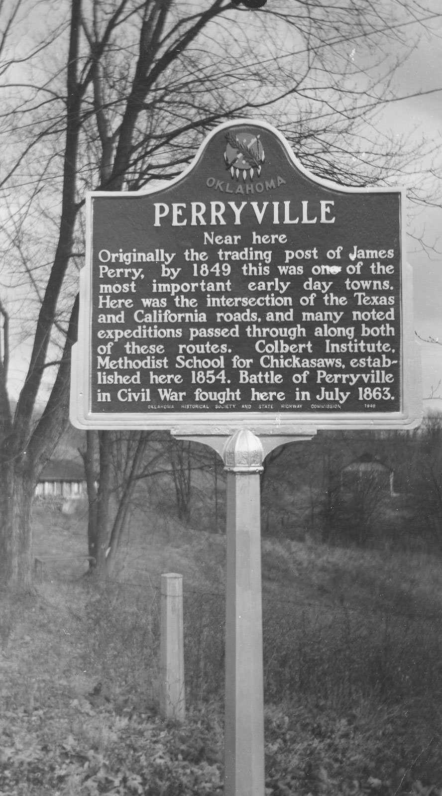
Perryville
Pittsburg CountyLocation: on US-69, three miles south of McAlester
Material: Aluminum
Note: Marker reported missing on 12/30/2023
Topics: Indian and Frontier Trade, Westward Expansion 1803–1861, Transportation, Military, Government
James Perry established an important trading post here in 1849 at the intersection of the Texas and California roads. Many famous expeditions passed through the area. A Confederate supply depot here was attacked and destroyed by Union soldiers on August 25, 1863.
Senator Gene Stipe
Pittsburg CountyLocation: on Stipe family home place on Peacable Mountain north of Blanco, south of McAlester
Material: Granite
Topics: Government, Social/Cultural, Recreational/Service, Industrial Period 1841–1892
When he retired in 2003, Gene Stipe had served in a state legislature longer than anyone else in American history. He was first elected to the Oklahoma House of Representatives in 1948 and moved to the State Senate in 1957, serving as the senior member of that body for many years.
(Page 1 of 1)
Search for Markers
Search by keyword or browse by county to learn about more than 600 historical markers created to recognize key locations, events, and people in Oklahoma history.
Please note that some markers listed in this database may have been moved, damaged, or are no longer standing.
Browse by County
Adair County
Alfalfa County
Atoka County
Beaver County
Beckham County
Blaine County
Bryan County
Caddo County
Canadian County
Carter County
Cherokee County
Choctaw County
Cimarron County
Cleveland County
Comanche County
Cotton County
Craig County
Creek County
Custer County
Delaware County
Dewey County
Ellis County
Garfield County
Garvin County
Grady County
Grant County
Greer County
Harmon County
Harper County
Haskell County
Hughes County
Jackson County
Jefferson County
Johnston County
Kay County
Kingfisher County
Kiowa County
Latimer CountyAlfalfa County
Atoka County
Beaver County
Beckham County
Blaine County
Bryan County
Caddo County
Canadian County
Carter County
Cherokee County
Choctaw County
Cimarron County
Cleveland County
Comanche County
Cotton County
Craig County
Creek County
Custer County
Delaware County
Dewey County
Ellis County
Garfield County
Garvin County
Grady County
Grant County
Greer County
Harmon County
Harper County
Haskell County
Hughes County
Jackson County
Jefferson County
Johnston County
Kay County
Kingfisher County
Kiowa County
Le Flore County
Lincoln County
Logan County
Love County
Marshall County
Mayes County
McClain County
McCurtain County
McIntosh County
Murray County
Muskogee County
Noble County
Okfuskee County
Oklahoma County
Okmulgee County
Osage County
Ottawa County
Pawnee County
Payne County
Pittsburg County
Pontotoc County
Pottawatomie County
Pushmataha County
Roger Mills County
Rogers County
Seminole County
Sequoyah County
Stephens County
Texas County
Tillman County
Tulsa County
Wagoner County
Washington County
Washita County
Woods County
Woodward County
Contact Us
If you have questions, please contact:
Matthew Pearce
Oklahoma Historical Society
800 Nazih Zuhdi Drive
Oklahoma City, OK 73105
405-522-8659
matthew.pearce@history.ok.gov