
Home | About OHS | Historical Marker Program
Location: on US-64, two miles east of Camp Houston
Coordinates: 36.81235, -99.07458
Sponsored by: Cherokee Strip Volunteer League and the Oklahoma Historical Society
Material: Aluminum
Topics: American Indians, Military, Government, Territorial Period 1861–1907
The last known encounter between American Indians and the federal government in Oklahoma occurred in this area on September 13–14, 1878. Units of the 4th Cavalry battled with Northern Cheyennes led by Dull Knife and Little Wolf as they fled Indian Territory to return to the north. An Arapaho scout and three soldiers were killed.
Location: at southeast corner of the county courthouse in Alva (DAR)
Coordinates: 36.803911, -98.664710
Sponsored by: Daughters of the American Revolution
Material: Other (Brick wall with bronze plaque and statuary)
Topics: Land Openings, Settlement Patterns, Government, Territorial Period 1861–1907
The 1,600 bricks in the wall list the names of past and present Woods County families and commemorate the centennial of the opening of the Cherokee Outlet in 1893.
Location: at intersection of Flynn and Post Office streets in Alva (DAR)
Coordinates: 36.804733, -98.664470
Sponsored by: Daughters of the American Revolution
Material: Stone with bronze plaque
Topics: Land Openings, Settlement Patterns, Government, Territorial Period 1861–1907
The first land office in the Cherokee Outlet was located here.
Location: approx. 12 miles north of Camp Houston
Coordinates: 36.96656, -99.14971
Sponsored by: Alva Monument
Material: Granite
Topics: Territorial Period 1861–1907, Settlement Patterns, Ranching, Indian Frontier and Trade
On September 12, 1878, the bodies of Reuben Bristow and Fred Clark were found near here. It was believed they had been killed by Northern Cheyenne Indians led by Chief Dull Knife. Bristow and Clark were cowboys hauling salt for Comanche pool cattle when Dull Knife fled harsh conditions on the reservation near Canton. The salt haulers, probably killed for their mule team, inadvertently crossed the path of the Cheyenne during their desperate flight home to the Northern Plains.
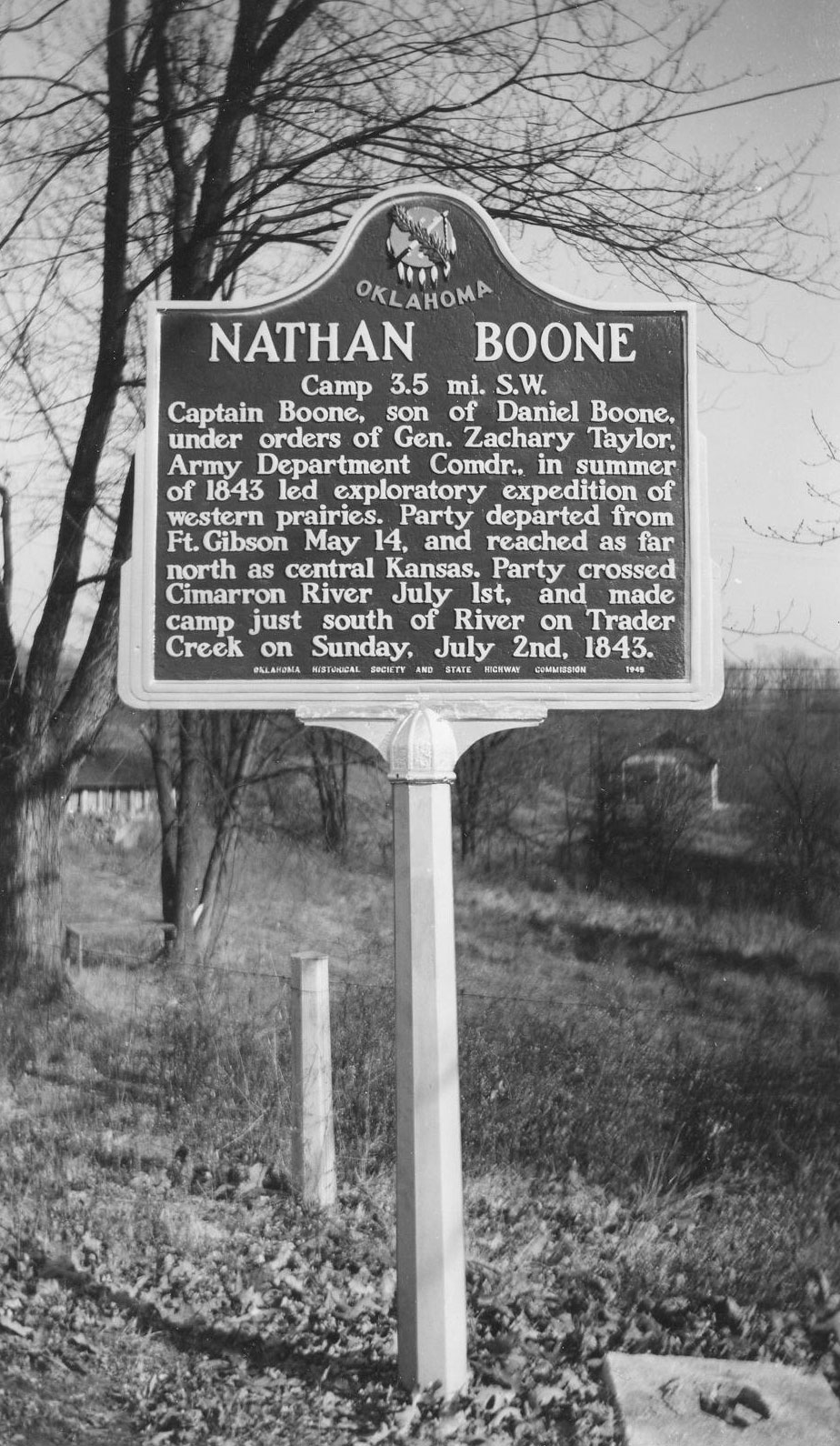
Location: on US-64, one mile west of Camp Houston
Coordinates: 36.81231, -99.12906
Sponsored by: Oklahoma Historical Society and State Highway Commission (ODOT)
Material: Aluminum
Note: Marker reported missing
Topics: Military, Westward Expansion 1803–1861, Government, Settlement Patterns
The son of frontiersman Daniel Boone, Nathan Boone, led an expedition to Indian Territory and through this area in 1843.
Location: American Legion Park in Freedom
Coordinates: 36.769423, -99.112640
Sponsored by: Cimarron Cowboys Association
Material: Granite
Topics: Land Openings, Settlement Patterns, Ranching, Territorial Period 1861–1907, Early Statehood 1907–1941
Commemorates the cowboys and ranchers who founded and developed the cattle industry in the Cimarron country of northwest Oklahoma.
Le Flore County
Lincoln County
Logan County
Love County
Marshall County
Mayes County
McClain County
McCurtain County
McIntosh County
Murray County
Muskogee County
Noble County
Okfuskee County
Oklahoma County
Okmulgee County
Osage County
Ottawa County
Pawnee County
Payne County
Pittsburg County
Pontotoc County
Pottawatomie County
Pushmataha County
Roger Mills County
Rogers County
Seminole County
Sequoyah County
Stephens County
Texas County
Tillman County
Tulsa County
Wagoner County
Washington County
Washita County
Woods County
Woodward County
Historical Marker Program
Search Results
Your search returned 6 results.
Battle of Turkey Springs
Woods CountyLocation: on US-64, two miles east of Camp Houston
Coordinates: 36.81235, -99.07458
Sponsored by: Cherokee Strip Volunteer League and the Oklahoma Historical Society
Material: Aluminum
Topics: American Indians, Military, Government, Territorial Period 1861–1907
The last known encounter between American Indians and the federal government in Oklahoma occurred in this area on September 13–14, 1878. Units of the 4th Cavalry battled with Northern Cheyennes led by Dull Knife and Little Wolf as they fled Indian Territory to return to the north. An Arapaho scout and three soldiers were killed.
Centennial Wall
Woods CountyLocation: at southeast corner of the county courthouse in Alva (DAR)
Coordinates: 36.803911, -98.664710
Sponsored by: Daughters of the American Revolution
Material: Other (Brick wall with bronze plaque and statuary)
Topics: Land Openings, Settlement Patterns, Government, Territorial Period 1861–1907
The 1,600 bricks in the wall list the names of past and present Woods County families and commemorate the centennial of the opening of the Cherokee Outlet in 1893.
Cherokee Strip
Woods CountyLocation: at intersection of Flynn and Post Office streets in Alva (DAR)
Coordinates: 36.804733, -98.664470
Sponsored by: Daughters of the American Revolution
Material: Stone with bronze plaque
Topics: Land Openings, Settlement Patterns, Government, Territorial Period 1861–1907
The first land office in the Cherokee Outlet was located here.
Cowboy Cemetery
Woods CountyLocation: approx. 12 miles north of Camp Houston
Coordinates: 36.96656, -99.14971
Sponsored by: Alva Monument
Material: Granite
Topics: Territorial Period 1861–1907, Settlement Patterns, Ranching, Indian Frontier and Trade
On September 12, 1878, the bodies of Reuben Bristow and Fred Clark were found near here. It was believed they had been killed by Northern Cheyenne Indians led by Chief Dull Knife. Bristow and Clark were cowboys hauling salt for Comanche pool cattle when Dull Knife fled harsh conditions on the reservation near Canton. The salt haulers, probably killed for their mule team, inadvertently crossed the path of the Cheyenne during their desperate flight home to the Northern Plains.
Nathan Boone
Woods CountyLocation: on US-64, one mile west of Camp Houston
Coordinates: 36.81231, -99.12906
Sponsored by: Oklahoma Historical Society and State Highway Commission (ODOT)
Material: Aluminum
Note: Marker reported missing
Topics: Military, Westward Expansion 1803–1861, Government, Settlement Patterns
The son of frontiersman Daniel Boone, Nathan Boone, led an expedition to Indian Territory and through this area in 1843.
The Cimarron Cowboy
Woods CountyLocation: American Legion Park in Freedom
Coordinates: 36.769423, -99.112640
Sponsored by: Cimarron Cowboys Association
Material: Granite
Topics: Land Openings, Settlement Patterns, Ranching, Territorial Period 1861–1907, Early Statehood 1907–1941
Commemorates the cowboys and ranchers who founded and developed the cattle industry in the Cimarron country of northwest Oklahoma.
(Page 1 of 1)
Search for Markers
Search by keyword or browse by county to learn about more than 600 historical markers created to recognize key locations, events, and people in Oklahoma history.
Please note that some markers listed in this database may have been moved, damaged, or are no longer standing.
Browse by County
Adair County
Alfalfa County
Atoka County
Beaver County
Beckham County
Blaine County
Bryan County
Caddo County
Canadian County
Carter County
Cherokee County
Choctaw County
Cimarron County
Cleveland County
Comanche County
Cotton County
Craig County
Creek County
Custer County
Delaware County
Dewey County
Ellis County
Garfield County
Garvin County
Grady County
Grant County
Greer County
Harmon County
Harper County
Haskell County
Hughes County
Jackson County
Jefferson County
Johnston County
Kay County
Kingfisher County
Kiowa County
Latimer CountyAlfalfa County
Atoka County
Beaver County
Beckham County
Blaine County
Bryan County
Caddo County
Canadian County
Carter County
Cherokee County
Choctaw County
Cimarron County
Cleveland County
Comanche County
Cotton County
Craig County
Creek County
Custer County
Delaware County
Dewey County
Ellis County
Garfield County
Garvin County
Grady County
Grant County
Greer County
Harmon County
Harper County
Haskell County
Hughes County
Jackson County
Jefferson County
Johnston County
Kay County
Kingfisher County
Kiowa County
Le Flore County
Lincoln County
Logan County
Love County
Marshall County
Mayes County
McClain County
McCurtain County
McIntosh County
Murray County
Muskogee County
Noble County
Okfuskee County
Oklahoma County
Okmulgee County
Osage County
Ottawa County
Pawnee County
Payne County
Pittsburg County
Pontotoc County
Pottawatomie County
Pushmataha County
Roger Mills County
Rogers County
Seminole County
Sequoyah County
Stephens County
Texas County
Tillman County
Tulsa County
Wagoner County
Washington County
Washita County
Woods County
Woodward County
Contact Us
If you have questions, please contact:
Matthew Pearce
Oklahoma Historical Society
800 Nazih Zuhdi Drive
Oklahoma City, OK 73105
405-522-8659
matthew.pearce@history.ok.gov