
Home | About OHS | Historical Marker Program
Location: on US-183, one mile east of Fort Supply
Topics: Military, Territorial Period 1861–1907, American Indians, Government
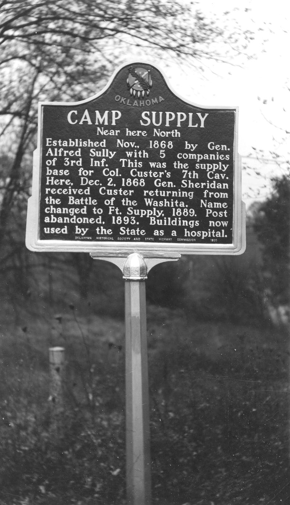
The site was used as a supply camp for Colonel George Armstrong Custer's 7th Cavalry in 1868. General Philip Sheridan received Custer here when he returned from the Battle of the Washita in December of 1868. The name was changed to Fort Supply in 1878 and abandoned in 1894. The State of Oklahoma later used the buildings for a hospital.
Location: in Boiling Springs State Park
Material: Granite
Topics: Environmental/Cultural Ecology, Social/Cultural, Government, Early Statehood 1907–1941, Recreation/Service
Company 2822 of the Civilian Conservation Corps (CCC) built the Boiling Springs State Park from 1935 to 1940 as part of the federal government's program to provide jobs during the Great Depression.
Location: on OK-34 at Ninth Street and Jefferson in Woodward
Topics: Transportation, American Indians, Indian and Frontier Trade, Settlement Patterns, Military
Originally a trail from Camp Supply to Darlington in the Cheyenne/Arapaho lands beginning in 1869, the road eventually became the main route of travel and supply between the two western forts.
Location: on OK-50, one mile west and three miles west of Mooreland
Topics: Transportation
See Crossing of Fort Supply to Fort Reno Road.
Location: at St. John's Episcopal Church at Tenth and Texas Streets in Woodward (DAR)
Sponsored by: Daughters of the American Revolution
Topics: Military, RD, Territorial Period 1861–1907, Retail, Transportation
Once considered to have been a military chapel at Fort Supply, the building was never located at the fort and actually was constructed sometime after 1888 in Woodward. A local businessman later had the building moved to its present location to accommodate a shorter walking distance for his wife.
Location: on US-270, one mile west of Fort Supply (DAR)
Sponsored by: Daughters of the American Revolution
Topics: Transportation, Military, Indian and Frontier Trade, Social/Cultural, Territorial Period 1861–190
A military road from Dodge City, Kansas, via Fort Supply, to Fort Elliott, Texas, carried supply wagons and a daily stagecoach through this area from 1874 to 1890.
Location: Sidewalk Peninsula at the Northeast Corner of 9th Street and Main in downtown Woodward, Oklahoma.
Material: Aluminum
Temple Lea Houston, the“lawyer with a gun,” was the youngest child of General Sam Houston of Texas fame. Temple was a gifted orator and an accomplished attorney. Possessed of great intellect, he contributed to the writing of many early Territorial statutes.
On this 800 block of Main Street, from his arrival in Woodward in 1893 until his untimely death in 1905, Temple Houston practiced law, spoke to rapt audiences, participated in a gunfight with the Jennings brothers, and was tried and acquitted for manslaughter in the shooting death of Ed Jennings.
A native Texan, he accomplished more in the last 12 years of his life here in the Oklahoma Territory than most people could achieve over the course of three lifetimes. He rests eternally here in his adopted home of Woodward next to his wife, Laura and three of their children.
"Mr. Houston dies regretted by the people of Oklahoma and Texas, each alike in their regard, one the state of his nativity, the other the land of his adoption. In neither never lived a brighter man or a kinder heart or one who leaves so many friends to regret his death," William Ezra Bolton, 1905
Location: Fort Supply
Sponsored by: Leland Bement
Topics: Pre-European Contact before 1541 AD, Social/Cultural, Recreational/Service, Environmental/Culural
Two miles northeast of here is the Cooper Paleo-Indian bison kill site. The site was the scene of three of the largest Folsom (ca. 10,500 years ago) bison kills known. Each event saw more than thirty bison herded into a dead-end gully. Hunters on the gully rim killed the animals with spears tipped with finely crafted Folsom points. A bison skull beneath the second kill was painted with red zigzag lines to ensure a successful hunt. The mineral pigment was red hematite. This is the oldest painted skull in North America and is the earliest evidence of hunting ritual for the Plains region.
Le Flore County
Lincoln County
Logan County
Love County
Marshall County
Mayes County
McClain County
McCurtain County
McIntosh County
Murray County
Muskogee County
Noble County
Okfuskee County
Oklahoma County
Okmulgee County
Osage County
Ottawa County
Pawnee County
Payne County
Pittsburg County
Pontotoc County
Pottawatomie County
Pushmataha County
Roger Mills County
Rogers County
Seminole County
Sequoyah County
Stephens County
Texas County
Tillman County
Tulsa County
Wagoner County
Washington County
Washita County
Woods County
Woodward County
Historical Marker Program
Search Results
Your search returned 8 results.
Camp Supply
Woodward CountyLocation: on US-183, one mile east of Fort Supply
Topics: Military, Territorial Period 1861–1907, American Indians, Government
The site was used as a supply camp for Colonel George Armstrong Custer's 7th Cavalry in 1868. General Philip Sheridan received Custer here when he returned from the Battle of the Washita in December of 1868. The name was changed to Fort Supply in 1878 and abandoned in 1894. The State of Oklahoma later used the buildings for a hospital.
CCC-Boiling Springs State Park
Woodward CountyLocation: in Boiling Springs State Park
Material: Granite
Topics: Environmental/Cultural Ecology, Social/Cultural, Government, Early Statehood 1907–1941, Recreation/Service
Company 2822 of the Civilian Conservation Corps (CCC) built the Boiling Springs State Park from 1935 to 1940 as part of the federal government's program to provide jobs during the Great Depression.
Crossing of Fort Supply to Fort Reno Road
Woodward CountyLocation: on OK-34 at Ninth Street and Jefferson in Woodward
Topics: Transportation, American Indians, Indian and Frontier Trade, Settlement Patterns, Military
Originally a trail from Camp Supply to Darlington in the Cheyenne/Arapaho lands beginning in 1869, the road eventually became the main route of travel and supply between the two western forts.
Crossing of Fort Supply to Fort Reno Road
Woodward CountyLocation: on OK-50, one mile west and three miles west of Mooreland
Topics: Transportation
See Crossing of Fort Supply to Fort Reno Road.
Military Chapel
Woodward CountyLocation: at St. John's Episcopal Church at Tenth and Texas Streets in Woodward (DAR)
Sponsored by: Daughters of the American Revolution
Topics: Military, RD, Territorial Period 1861–1907, Retail, Transportation
Once considered to have been a military chapel at Fort Supply, the building was never located at the fort and actually was constructed sometime after 1888 in Woodward. A local businessman later had the building moved to its present location to accommodate a shorter walking distance for his wife.
Military Road Crossing
Woodward CountyLocation: on US-270, one mile west of Fort Supply (DAR)
Sponsored by: Daughters of the American Revolution
Topics: Transportation, Military, Indian and Frontier Trade, Social/Cultural, Territorial Period 1861–190
A military road from Dodge City, Kansas, via Fort Supply, to Fort Elliott, Texas, carried supply wagons and a daily stagecoach through this area from 1874 to 1890.
Temple Houston (1860-1905)
Woodward CountyLocation: Sidewalk Peninsula at the Northeast Corner of 9th Street and Main in downtown Woodward, Oklahoma.
Material: Aluminum
Temple Lea Houston, the“lawyer with a gun,” was the youngest child of General Sam Houston of Texas fame. Temple was a gifted orator and an accomplished attorney. Possessed of great intellect, he contributed to the writing of many early Territorial statutes.
On this 800 block of Main Street, from his arrival in Woodward in 1893 until his untimely death in 1905, Temple Houston practiced law, spoke to rapt audiences, participated in a gunfight with the Jennings brothers, and was tried and acquitted for manslaughter in the shooting death of Ed Jennings.
A native Texan, he accomplished more in the last 12 years of his life here in the Oklahoma Territory than most people could achieve over the course of three lifetimes. He rests eternally here in his adopted home of Woodward next to his wife, Laura and three of their children.
"Mr. Houston dies regretted by the people of Oklahoma and Texas, each alike in their regard, one the state of his nativity, the other the land of his adoption. In neither never lived a brighter man or a kinder heart or one who leaves so many friends to regret his death," William Ezra Bolton, 1905
The Cooper Site
Woodward CountyLocation: Fort Supply
Sponsored by: Leland Bement
Topics: Pre-European Contact before 1541 AD, Social/Cultural, Recreational/Service, Environmental/Culural
Two miles northeast of here is the Cooper Paleo-Indian bison kill site. The site was the scene of three of the largest Folsom (ca. 10,500 years ago) bison kills known. Each event saw more than thirty bison herded into a dead-end gully. Hunters on the gully rim killed the animals with spears tipped with finely crafted Folsom points. A bison skull beneath the second kill was painted with red zigzag lines to ensure a successful hunt. The mineral pigment was red hematite. This is the oldest painted skull in North America and is the earliest evidence of hunting ritual for the Plains region.
(Page 1 of 1)
Search for Markers
Search by keyword or browse by county to learn about more than 600 historical markers created to recognize key locations, events, and people in Oklahoma history.
Please note that some markers listed in this database may have been moved, damaged, or are no longer standing.
Browse by County
Adair County
Alfalfa County
Atoka County
Beaver County
Beckham County
Blaine County
Bryan County
Caddo County
Canadian County
Carter County
Cherokee County
Choctaw County
Cimarron County
Cleveland County
Comanche County
Cotton County
Craig County
Creek County
Custer County
Delaware County
Dewey County
Ellis County
Garfield County
Garvin County
Grady County
Grant County
Greer County
Harmon County
Harper County
Haskell County
Hughes County
Jackson County
Jefferson County
Johnston County
Kay County
Kingfisher County
Kiowa County
Latimer CountyAlfalfa County
Atoka County
Beaver County
Beckham County
Blaine County
Bryan County
Caddo County
Canadian County
Carter County
Cherokee County
Choctaw County
Cimarron County
Cleveland County
Comanche County
Cotton County
Craig County
Creek County
Custer County
Delaware County
Dewey County
Ellis County
Garfield County
Garvin County
Grady County
Grant County
Greer County
Harmon County
Harper County
Haskell County
Hughes County
Jackson County
Jefferson County
Johnston County
Kay County
Kingfisher County
Kiowa County
Le Flore County
Lincoln County
Logan County
Love County
Marshall County
Mayes County
McClain County
McCurtain County
McIntosh County
Murray County
Muskogee County
Noble County
Okfuskee County
Oklahoma County
Okmulgee County
Osage County
Ottawa County
Pawnee County
Payne County
Pittsburg County
Pontotoc County
Pottawatomie County
Pushmataha County
Roger Mills County
Rogers County
Seminole County
Sequoyah County
Stephens County
Texas County
Tillman County
Tulsa County
Wagoner County
Washington County
Washita County
Woods County
Woodward County
Contact Us
If you have questions, please contact:
Matthew Pearce
Oklahoma Historical Society
800 Nazih Zuhdi Drive
Oklahoma City, OK 73105
405-522-8659
matthew.pearce@history.ok.gov