
Hillerman Map Project
Photographs of Oklahoma City

21412.M165.7, Z.P. Meyers/Barney Hillerman Photographic Collection, OHS (map #2Y)
The Biltmore Hotel
Address: 228 West Grand Avenue
View: Southeast
Date: October 1952
Architect: Hawk and Parr (Edwards and Ottaway, Vanished Splendor 49)
Built: 1932 (Edwards and Ottaway, Vanished Splendor 49)
Destroyed: 1977 (Lackmeyer 36)
"Located on the southeast corner of Grand and Harvey, the Biltmore Hotel was conceived and built during the Great Depression by prominent civic leaders, headed by Charles F. Colcord. Designed by architects Hawk and Parr, by the time it was completed in 1932, the Biltmore was thirty-three stories high and was heralded as the state's tallest building. Financial woes plagued the hotel throughout most of its life and the doors were closed in June 1973. Thousands of citizens turned out to watch as the massive structure was dynamited on October 16, 1977. Many cried openly, knowing that they were witnessing a singular episode of the destruction of historic Oklahoma City." (Edwards and Ottaway, Vanished Splendor 49)
"The Oklahoma Biltmore was without a doubt one of the finest hotels in the post-oil boom days of Oklahoma City. There were 619 rooms, each offering free radio, circulating ice water, ceiling fans with up-and-down draft, and later, air conditioning. In 1936 the Biltmore was headquarters for 104 conventions, served 284,604 meals, and had 114,171 guests! H.P. 'Johnnie' Johnson, manager, always said in the advertising, 'On your next visit to the Oil Capital be sure to register at the Biltmore.' 'On October 16, 1977 the Hotel Biltmore was demolished by a team of demolition specialists. Hundreds of low-yield explosives were planted throughout the building so that it would collapse and fall inward into an acceptable area only slightly larger than the hotel's foundation. The purpose was both to break the materials into smaller pieces that would be easily transported away, and to contain the blast and debris within the area, in order to minimize damage to surrounding structures. The razing was recorded by hundreds of camera buffs.'" (Edwards and Ottaway, Vanished Splendor II 287-288)
"After a $3 million renovation in the mid-1960s [the Biltmore] was renamed the Sheraton-Oklahoma Hotel. I.M. Pei envisioned keeping the hotel, and his sketches and models all showed the tower overlooking the surrounding 'Tivoli Gardens.' By 1973, the Sheraton brand was lost, and the Urban Renewal authority agreed with owners the Biltmore had outlived its useful life. The hotel was one of the largest demolitions in the country to date when it was blown up in 1977 to make way for the 'Myriad Gardens.'" (Lackmeyer and Money 36)
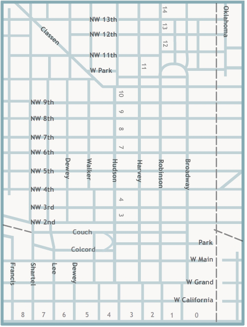
Click points or areas on the map to view historic photographs of downtown Oklahoma City.
- •
- Ford Assembling Plant
- •
- Municipal Auditorium
- •
- Bird’s Eye View of Civic Center and Courthouse
- •
- Old County Courthouse
- •
- Montgomery Ward Building
- •
- Hotel Black
- •
- Motor Hotel
- •
- Plaza Court
- •
- Gene Jones Motor Co.
- •
- Magnolia Petroleum Company
- •
- Rockwell Apartments
- •
- Masonic Temple (Home State Life Building)
- •
- Kirkpatrick Hotel
- •
- Elks Lodge (Key Building, ONG Building)
- •
- Federal Building
- •
- US Post Office
- •
- Federal Reserve Bank
- •
- Cotton-Exchange Building
- •
- Oklahoma County Courthouse
- •
- YWCA
- •
- Hightower Building
- •
- Mercantile Building (Levy Building)
- •
- Majestic Building
- •
- First National Building
- •
- Wright Building
- •
- Skirvin Tower
- •
- Rock Island Railroad Depot
- •
- Skirvin Hotel
- •
- Insurance Building
- •
- Public Warehouse Company
- •
- Patterson and Hoffman Wholesale Cigars and Pipes
- •
- Milner Hotel
- •
- Hotel Kingkade
- •
- Herskowitz Building
- •
- Santa Fe Railroad Station
- •
- Wells Roberts Hotel
- •
- Sooner Theatre
- •
- Colcord Building
- •
- Baltimore Building
- •
- Midwest Theatre
- •
- Kress
- •
- Lerner
- •
- Katz Drug
- •
- The American National Building
- •
- Empire Building
- •
- Criterion Theatre
- •
- Biltmore Hotel
- •
- Oklahoma Club Building
- •
- Farmer's National Bank Building
- •
- Commerce Exchange Building
- •
- Huckins Hotel, Huckins Garage
- •
- Campbell Building
- •
- Hales Building
- •
- Fidelity Bank
- •
- Britling Cafeteria
- •
- Manly Office Supply Company
- •
- Perrine Building, Cravens Building
- •
- Baum Building
- •
- Security National Building
- •
- Ramsey Tower, City National Building
- •
- Petroleum Building
- •
- Franklin Building
- •
- Braniff Building
- •
- Kerr-McGee Building
- •
- Capitol Federal Savings and Loan
- •
- Telephone, Pioneer, Southwestern Bell
- •
- Street View
- •
- Street View
- •
- Street View
- •
- Street View
- •
- Street View
- •
- Street View
- •
- Street View
- •
- Street View
- •
- Street View
- •
- Parade on Broadway
- •
- Street View
- •
- Street View
- •
- Aerial View
- •
- Bird’s Eye View
- •
- Bird’s Eye View
- •
- Bird’s Eye View
The Z. P. Meyers/Barney Hillerman Photographic Collection
The Z. P. Meyers/Barney Hillerman Photographic Collection includes thousands of images, many of which depict businesses in Oklahoma City. Many photographs in the collection are from the Meyers Photo Shop, which employed Barney Hillerman and other photographers. This map highlights significant buildings in the downtown Oklahoma City area, as well as street and aerial views. The map features images dating from the late 1920s to the 1960s.
This project was made possible by a grant from the Pauline Dwyer Macklanburg and Robert A. Macklanburg Jr. Foundation.
You can view more images from the Z. P. Meyers/Barney Hillerman Photographic Collection on The Gateway to Oklahoma History.
Visit The Gateway to Oklahoma History.