
Archaeology in Oklahoma
Surveying in Oklahoma
When an archaeologist is looking for a site, they conduct surveys of the area so they know the location and size. A typical survey consists of several people trained to identify sites walking up to five feet apart from each other and walking in a straight line. Once a site or an artifact has been found, the archaeologist will use the Global Positioning System (GPS) to record the location of the site/artifact so that they are able to come back later and excavate it. Archaeologists use special GPS devices that are made for surveying. These devices give the archaeologist the coordinates, (latitude/longitude). They also may excavate a shovel test pit to see how deep the site/artifact goes into the ground. Once they excavate the shovel test pit, they use a screen to sift through the dirt they took out of the hole and look for small artifacts. Next, they collect the artifacts record them along with the GPS coordinates of the hole. Then, an archaeologist will move on to the next area to excavate another shovel test pit until they have found the size of the site. They mark these coordinates out on a map to show where artifacts are located, as well as where the site is located. After they have mapped everything out, they will start to excavate.
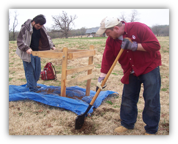
(Photograph courtesy of the Oklahoma Archeological Survey.)