
Home | About OHS | Historical Marker Program
Location: on US-59 south of Sallisaw near junction with OK-9 (OBHC)
Topics: Religion/Philosophy, Westward Expansion 1803–1861
A Baptist church organized in a brush arbor here in 1837. This church and seven other churches formed the Short Mountain Association in 1844, the first and oldest Anglo Baptist Association in Oklahoma.
Location: on US-64 east of Vian at junction with road to Marble City
Material: Granite
Topics: Religion/Philosophy, Education, American Indians, Westward Expansion 1803–1861
The American Board of Commissioners for Foreign Missions purchased and used the site as a base for missionary work. Reverend Cephas Washburn built a school for the Cherokees here in 1828, a successor to a school he founded in Arkansas. For four decades, Washburn provided educational leadership among the Cherokees.
Location: on US-64 west of Arkansas border at Moffett
Material: Originally aluminum, now granite
Topics: Transportation, Westward Expansion 1803–1861
The first highway in Oklahoma, fifty-six miles from Fort Smith to Fort Gibson, was completed in 1827.
Location: on OK-101, eleven miles northeast of Sallisaw
Topics: Westward Expansion 1803–1861, Family/Household, American Indians, Arts
Built in the 1830s, this log cabin served as home to George Guess, also known as Sequoyah, the developer of the Cherokee syllabary. Sequoyah is considered one of the great leaders in American Indian education because of the development of a written language for the Cherokees.
Location: on US-64, two miles east of Gore
Material: Aluminum
Topics: Westward Expansion 1803–1861, American Indians, Folklife, Indian and Frontier Trade
In 1829, the village became the western capital of the Cherokees. Sam Houston often visited the area in trade missions into Indian Territory and was given the name "The Raven" by Cherokee leaders.
Le Flore County
Lincoln County
Logan County
Love County
Marshall County
Mayes County
McClain County
McCurtain County
McIntosh County
Murray County
Muskogee County
Noble County
Okfuskee County
Oklahoma County
Okmulgee County
Osage County
Ottawa County
Pawnee County
Payne County
Pittsburg County
Pontotoc County
Pottawatomie County
Pushmataha County
Roger Mills County
Rogers County
Seminole County
Sequoyah County
Stephens County
Texas County
Tillman County
Tulsa County
Wagoner County
Washington County
Washita County
Woods County
Woodward County
Historical Marker Program
Search Results
Your search returned 5 results.
Baptists at Cowlington
Sequoyah CountyLocation: on US-59 south of Sallisaw near junction with OK-9 (OBHC)
Topics: Religion/Philosophy, Westward Expansion 1803–1861
A Baptist church organized in a brush arbor here in 1837. This church and seven other churches formed the Short Mountain Association in 1844, the first and oldest Anglo Baptist Association in Oklahoma.
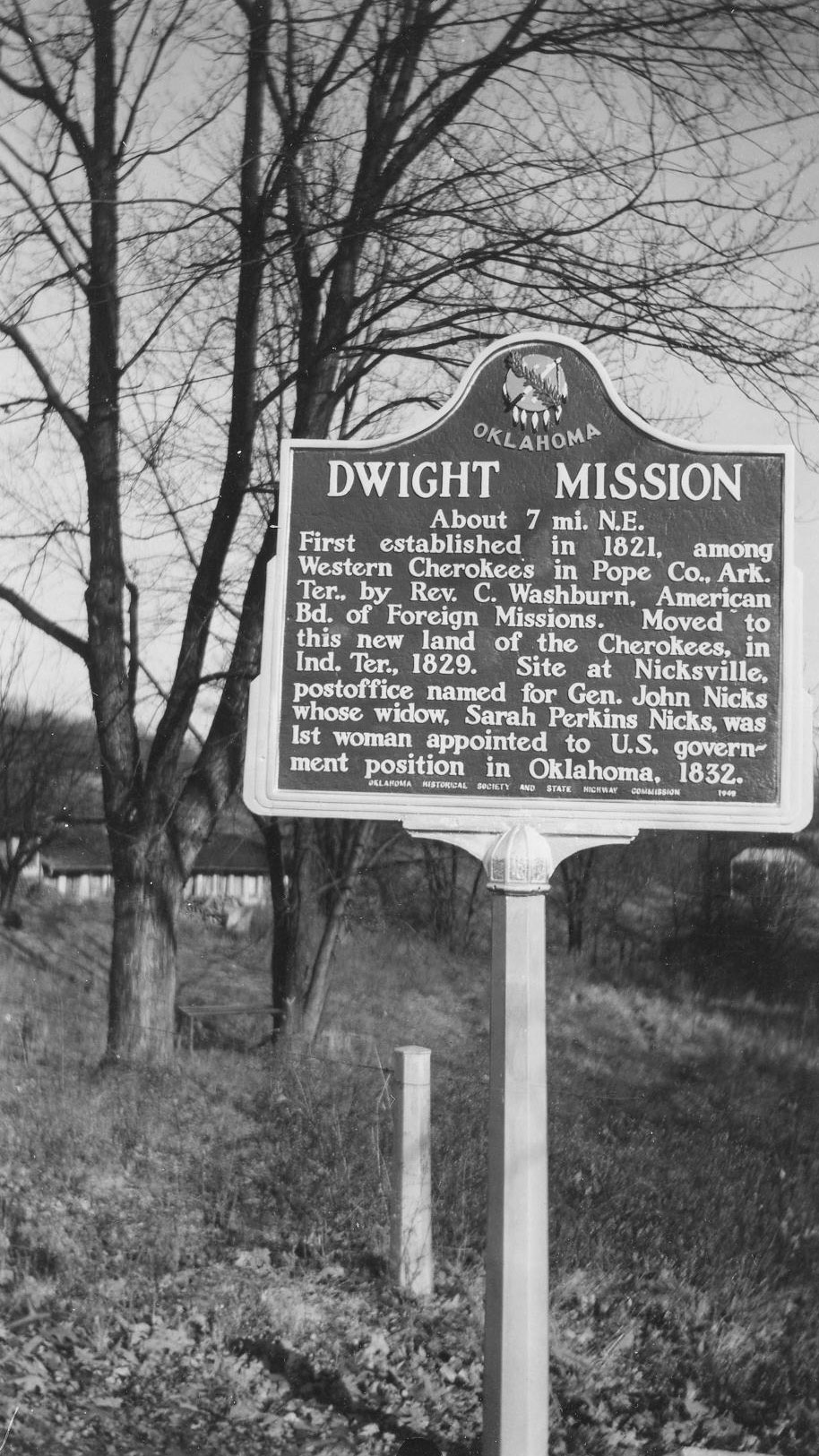
Dwight Mission
Sequoyah CountyLocation: on US-64 east of Vian at junction with road to Marble City
Material: Granite
Topics: Religion/Philosophy, Education, American Indians, Westward Expansion 1803–1861
The American Board of Commissioners for Foreign Missions purchased and used the site as a base for missionary work. Reverend Cephas Washburn built a school for the Cherokees here in 1828, a successor to a school he founded in Arkansas. For four decades, Washburn provided educational leadership among the Cherokees.
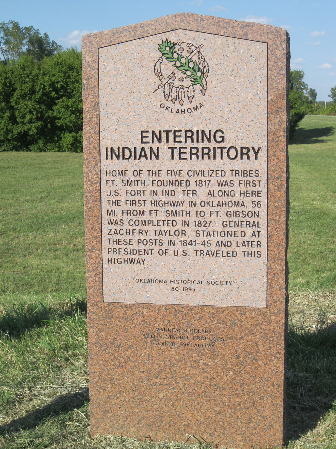
Entering Indian Territory
Sequoyah CountyLocation: on US-64 west of Arkansas border at Moffett
Material: Originally aluminum, now granite
Topics: Transportation, Westward Expansion 1803–1861
The first highway in Oklahoma, fifty-six miles from Fort Smith to Fort Gibson, was completed in 1827.
Sequoyah's Home
Sequoyah CountyLocation: on OK-101, eleven miles northeast of Sallisaw
Topics: Westward Expansion 1803–1861, Family/Household, American Indians, Arts
Built in the 1830s, this log cabin served as home to George Guess, also known as Sequoyah, the developer of the Cherokee syllabary. Sequoyah is considered one of the great leaders in American Indian education because of the development of a written language for the Cherokees.
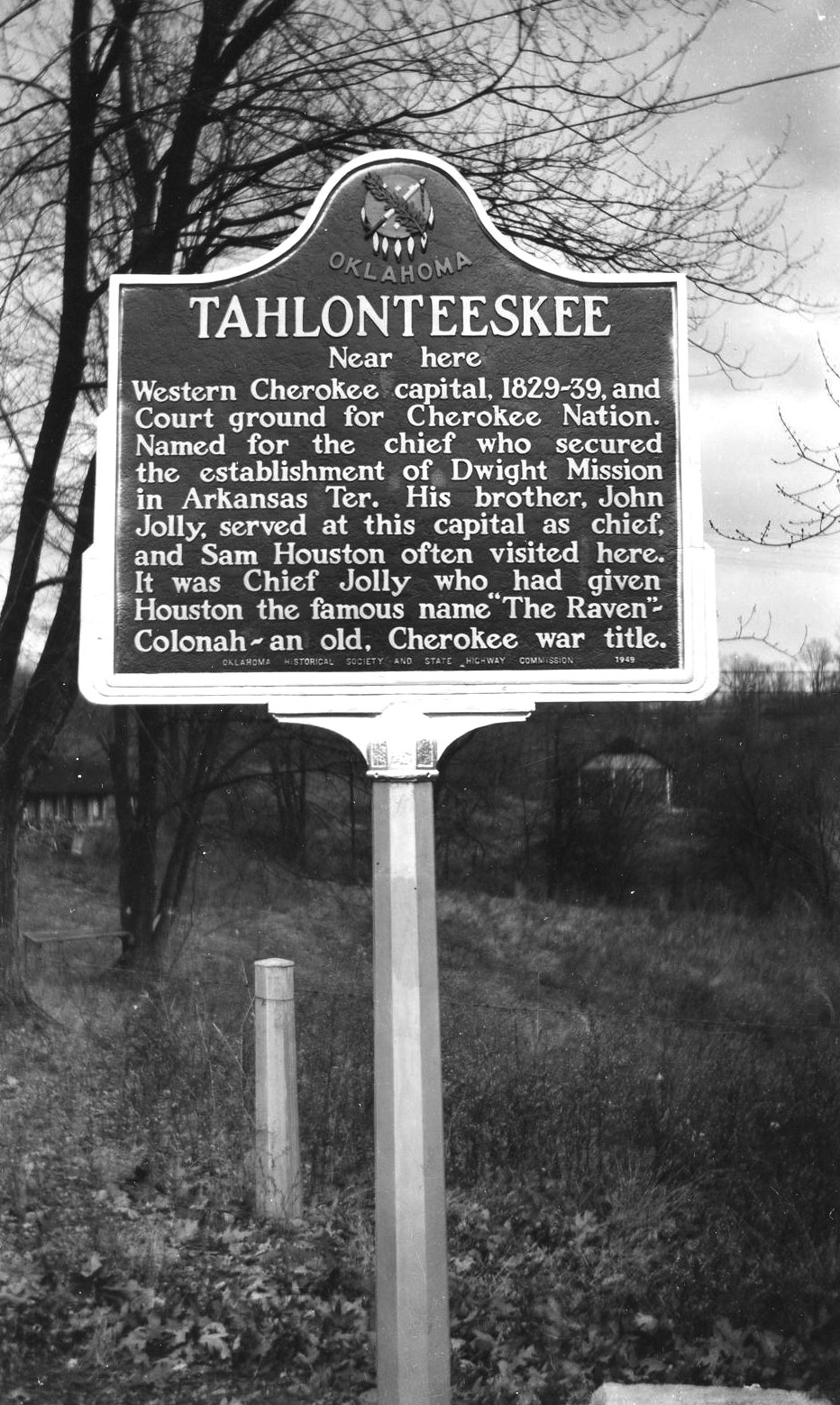
Tahlonteeskee
Sequoyah CountyLocation: on US-64, two miles east of Gore
Material: Aluminum
Topics: Westward Expansion 1803–1861, American Indians, Folklife, Indian and Frontier Trade
In 1829, the village became the western capital of the Cherokees. Sam Houston often visited the area in trade missions into Indian Territory and was given the name "The Raven" by Cherokee leaders.
(Page 1 of 1)
Search for Markers
Search by keyword or browse by county to learn about more than 600 historical markers created to recognize key locations, events, and people in Oklahoma history.
Please note that some markers listed in this database may have been moved, damaged, or are no longer standing.
Browse by County
Adair County
Alfalfa County
Atoka County
Beaver County
Beckham County
Blaine County
Bryan County
Caddo County
Canadian County
Carter County
Cherokee County
Choctaw County
Cimarron County
Cleveland County
Comanche County
Cotton County
Craig County
Creek County
Custer County
Delaware County
Dewey County
Ellis County
Garfield County
Garvin County
Grady County
Grant County
Greer County
Harmon County
Harper County
Haskell County
Hughes County
Jackson County
Jefferson County
Johnston County
Kay County
Kingfisher County
Kiowa County
Latimer CountyAlfalfa County
Atoka County
Beaver County
Beckham County
Blaine County
Bryan County
Caddo County
Canadian County
Carter County
Cherokee County
Choctaw County
Cimarron County
Cleveland County
Comanche County
Cotton County
Craig County
Creek County
Custer County
Delaware County
Dewey County
Ellis County
Garfield County
Garvin County
Grady County
Grant County
Greer County
Harmon County
Harper County
Haskell County
Hughes County
Jackson County
Jefferson County
Johnston County
Kay County
Kingfisher County
Kiowa County
Le Flore County
Lincoln County
Logan County
Love County
Marshall County
Mayes County
McClain County
McCurtain County
McIntosh County
Murray County
Muskogee County
Noble County
Okfuskee County
Oklahoma County
Okmulgee County
Osage County
Ottawa County
Pawnee County
Payne County
Pittsburg County
Pontotoc County
Pottawatomie County
Pushmataha County
Roger Mills County
Rogers County
Seminole County
Sequoyah County
Stephens County
Texas County
Tillman County
Tulsa County
Wagoner County
Washington County
Washita County
Woods County
Woodward County
Contact Us
If you have questions, please contact:
Matthew Pearce
Oklahoma Historical Society
800 Nazih Zuhdi Drive
Oklahoma City, OK 73105
405-522-8659
matthew.pearce@history.ok.gov