Historical Marker Program
Search Results
Your search returned 4 results.
Edwards’s Post
Hughes CountyLocation: on OK-48 south of Holdenville
Coordinates: 35.018887, -96.367855
Material: Aluminum
Sponsor(s): Oklahoma Historical Society and the Oklahoma Department of Transportation
Topics: American Indians; Indian and Frontier Trade; Westward Expansion, 1803–1861
Edwards’s Post was established c. 1835 by the firm Edwards and Shelton near the site of Camp Canadian (also known as Fort Holmes), which had been established for the Dodge-Leavenworth Expedition and subsequently abandoned. James Edwards, the post’s chief proprietor, was a white trader married to a Muscogee (Creek) woman. Jesse Chisholm worked for Edwards and married his daughter, Eliza. Native and white traders met at Edwards’s Post to exchange goods, horses and mules, and captives prior to the Civil War.
Note: This marker replaced the Fort Holmes historical marker.

View image
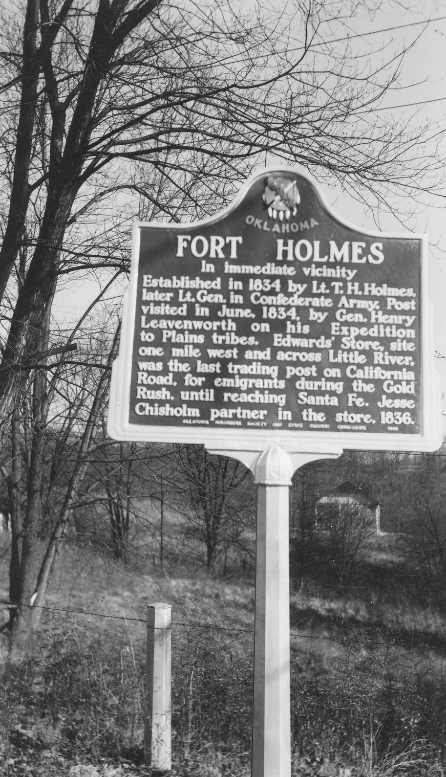
Fort Holmes
Hughes CountyLocation: on OK-48 west of Kenefic
Topics: American Indians; Military; Westward Expansion, 1803–1861
This frontier fort was established by Lieutenant Theophilus Holmes who later rose to the rank of lieutenant general in the Confederate Army. Holmes built temporary barracks for troops in 1834 to serve as an advance base for troops stationed at Fort Towson. General Henry Leavenworth visited here on his 1834 expedition to the Plains Tribes.
Note: This marker has been replaced by the Edwards’s Post historical marker.
View image
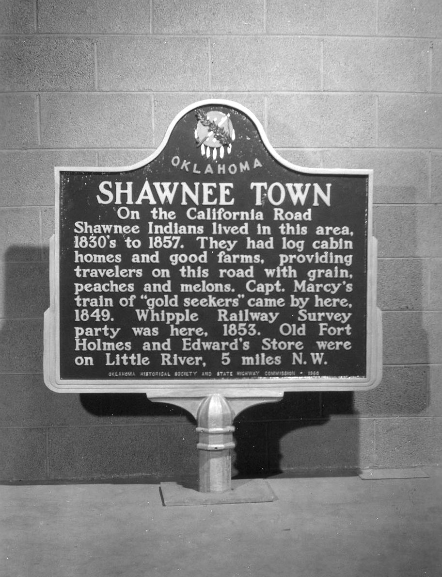
Shawnee Town
Hughes CountyLocation: on OK-12, one mile west of Atwood
Topics: American Indians; Settlement Patterns; Territorial Period, 1861–1907; Urban Development
The town was a settlement of Absentee Shawnee and Delaware on the California Road. The tribes had migrated from Ohio before 1800 and were allowed by the Choctaw National Council to remain in the area. The Absentee Shawnee occupied the site on the South Canadian River until 1857 when they moved northward to the Creek Nation and settled near Tecumseh in present Pottawatomie County.
Note: This marker was reported missing on 6/8/2023.
View image
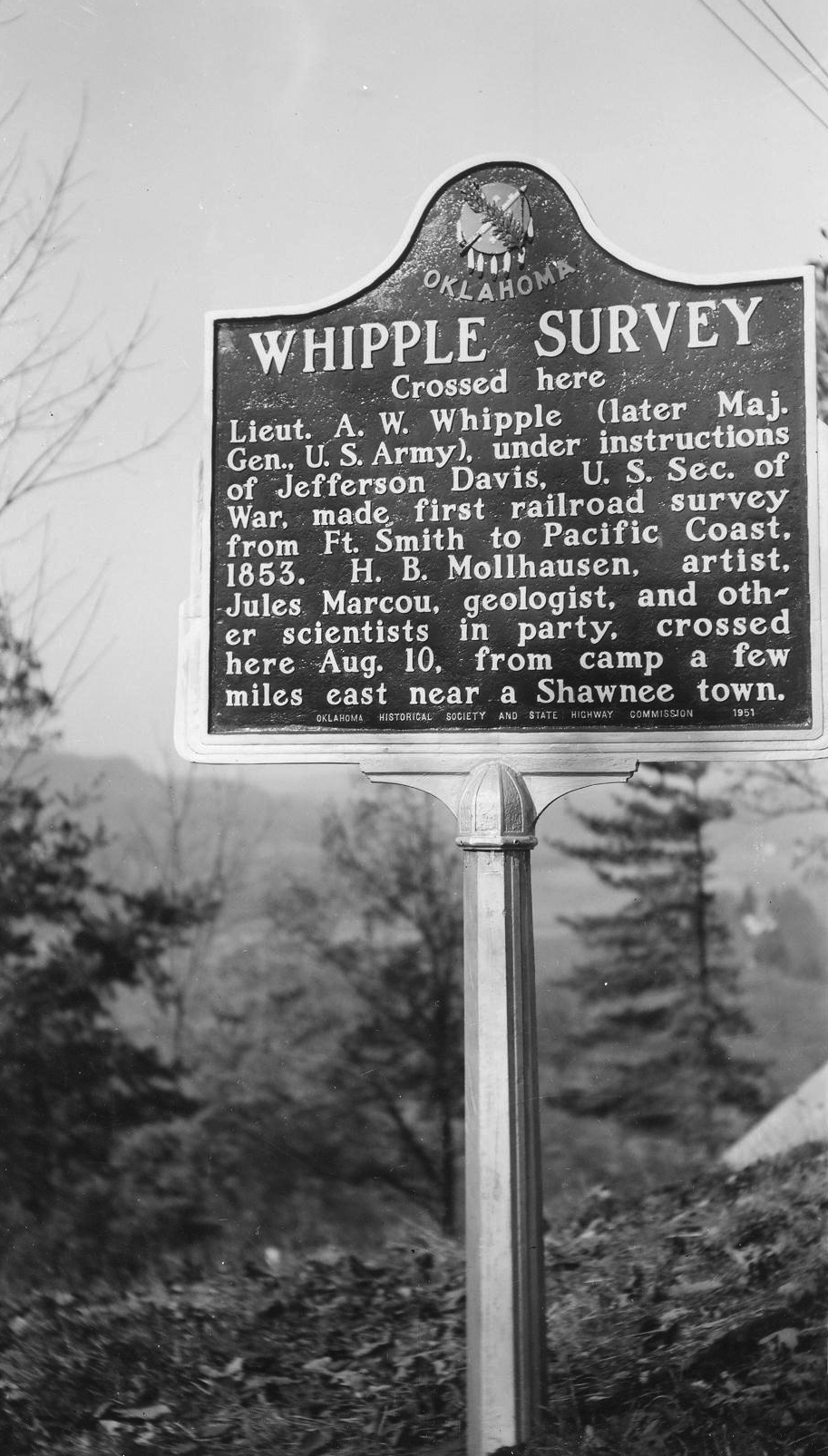
Whipple Survey
Hughes CountyLocation: on US-75, three to four miles south of Calvin
Material: Aluminum
Topics: Arts; Government; Military; Natural Resources; Transportation; Westward Expansion, 1803–1861
Under instructions of Jefferson Davis, US Secretary of War, Lieutenant A. W. Whipple (later Major General, US Army) made the first railroad survey from Fort Smith to the Pacific Coast in 1853. With H. B. Mollhausen, artist, Jules Marcou, geologist, and other scientists in the party, they crossed here on August 10 from camp a few miles east near Shawnee Town.
Note: This marker was reported missing on 6/8/2023.
View image
(Page 1 of 1)
Marker Search
Use quotation marks to search for an exact phrase.
Browse by County
Adair County
Alfalfa County
Atoka County
Beaver County
Beckham County
Blaine County
Bryan County
Caddo County
Canadian County
Carter County
Cherokee County
Choctaw County
Cimarron County
Cleveland County
Comanche County
Cotton County
Craig County
Creek County
Custer County
Delaware County
Dewey County
Ellis County
Garfield County
Garvin County
Grady County
Grant County
Greer County
Harmon County
Harper County
Haskell County
Hughes County
Jackson County
Jefferson County
Johnston County
Kay County
Kingfisher County
Kiowa County
Latimer County
Le Flore County
Lincoln County
Logan County
Love County
Major County
Marshall County
Mayes County
McClain County
McCurtain County
McIntosh County
Murray County
Muskogee County
Noble County
Nowata County
Okfuskee County
Oklahoma County
Okmulgee County
Osage County
Ottawa County
Pawnee County
Payne County
Pittsburg County
Pontotoc County
Pottawatomie County
Pushmataha County
Roger Mills County
Rogers County
Seminole County
Sequoyah County
Stephens County
Texas County
Tillman County
Tulsa County
Wagoner County
Washington County
Washita County
Woods County
Woodward County
Alfalfa County
Atoka County
Beaver County
Beckham County
Blaine County
Bryan County
Caddo County
Canadian County
Carter County
Cherokee County
Choctaw County
Cimarron County
Cleveland County
Comanche County
Cotton County
Craig County
Creek County
Custer County
Delaware County
Dewey County
Ellis County
Garfield County
Garvin County
Grady County
Grant County
Greer County
Harmon County
Harper County
Haskell County
Hughes County
Jackson County
Jefferson County
Johnston County
Kay County
Kingfisher County
Kiowa County
Latimer County
Le Flore County
Lincoln County
Logan County
Love County
Major County
Marshall County
Mayes County
McClain County
McCurtain County
McIntosh County
Murray County
Muskogee County
Noble County
Nowata County
Okfuskee County
Oklahoma County
Okmulgee County
Osage County
Ottawa County
Pawnee County
Payne County
Pittsburg County
Pontotoc County
Pottawatomie County
Pushmataha County
Roger Mills County
Rogers County
Seminole County
Sequoyah County
Stephens County
Texas County
Tillman County
Tulsa County
Wagoner County
Washington County
Washita County
Woods County
Woodward County
To find out more about the Oklahoma Historical Society Historical Marker Program or how to submit an application, please visit the Historical Marker Program page.
Missing or Damaged Markers
Please use our online form to report missing or damaged historical markers.
Report Missing or Damaged Markers
Contact Us
If you have questions, please contact:
Matthew Pearce
Oklahoma Historical Society
800 Nazih Zuhdi Drive
Oklahoma City, OK 73105
405-522-8659
[email protected]
