
Historical Marker Program
Search Results
Your search returned 14 results.
Chief's Old House
Choctaw CountyLocation: on county road, two miles northeast of Swink
Sponsored by: Swink Historical Preservation Association
Material: Granite
Note: Unable to locate marker
Topics: American Indians, Family/Household, Westward Expansion 1803–1861, Settlement Patterns
According to some this is the oldest house still standing in Oklahoma, having been built in 1832 by the federal government for Choctaw District Chief Thomas LeFlore under its treaty obligations with the Choctaw Nation. Recent scholarship indicates that the home built for LeFlore stood west of Wheelock Mission in McCurtain County. However, this old house is representative of a typical Choctaw planter's home in the mid-nineteenth century.
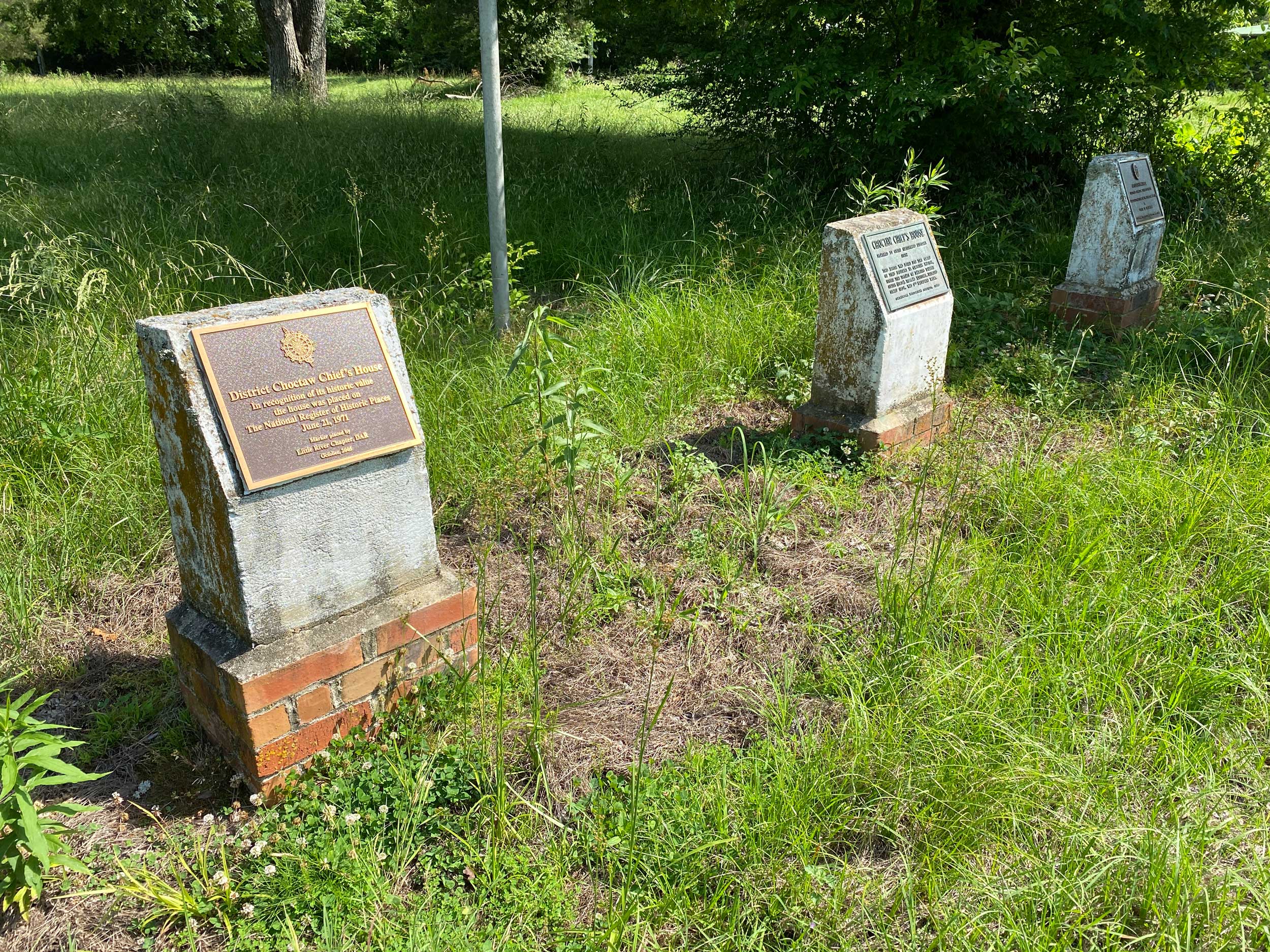

Choctaw Chief's House
Choctaw CountyLocation: on grounds of house, two miles northeast of Swink
Coordinates: 34.023164, -95.181443
Material: Concrete with bronze plaque
Topics: American Indians, Family/Household, Westward Expansion 1803–1861, Settlement Patterns
Three concrete markers commemorate what was once known as Choctaw Chief's House. This house was originally believed to have been constructed for Choctaw District Chief Thomas LeFlore in 1832 per terms of the Treaty of Dancing Rabbit Creek (1830). Subsequent research uncovered that Chief LeFlore's House likely stood west of Wheelock Mission in McCurtain County. See "Chief's Old House." Also see Louis Coleman, "The Choctaw Chief's House: Oral Tradition and Historical Inaccuracies," The Chronicles of Oklahoma 81, No. 4 (Winter 2003-04): 492–501. Markers’ sponsors include the Oklahoma Historical Society and Daughters of the American Revolution.
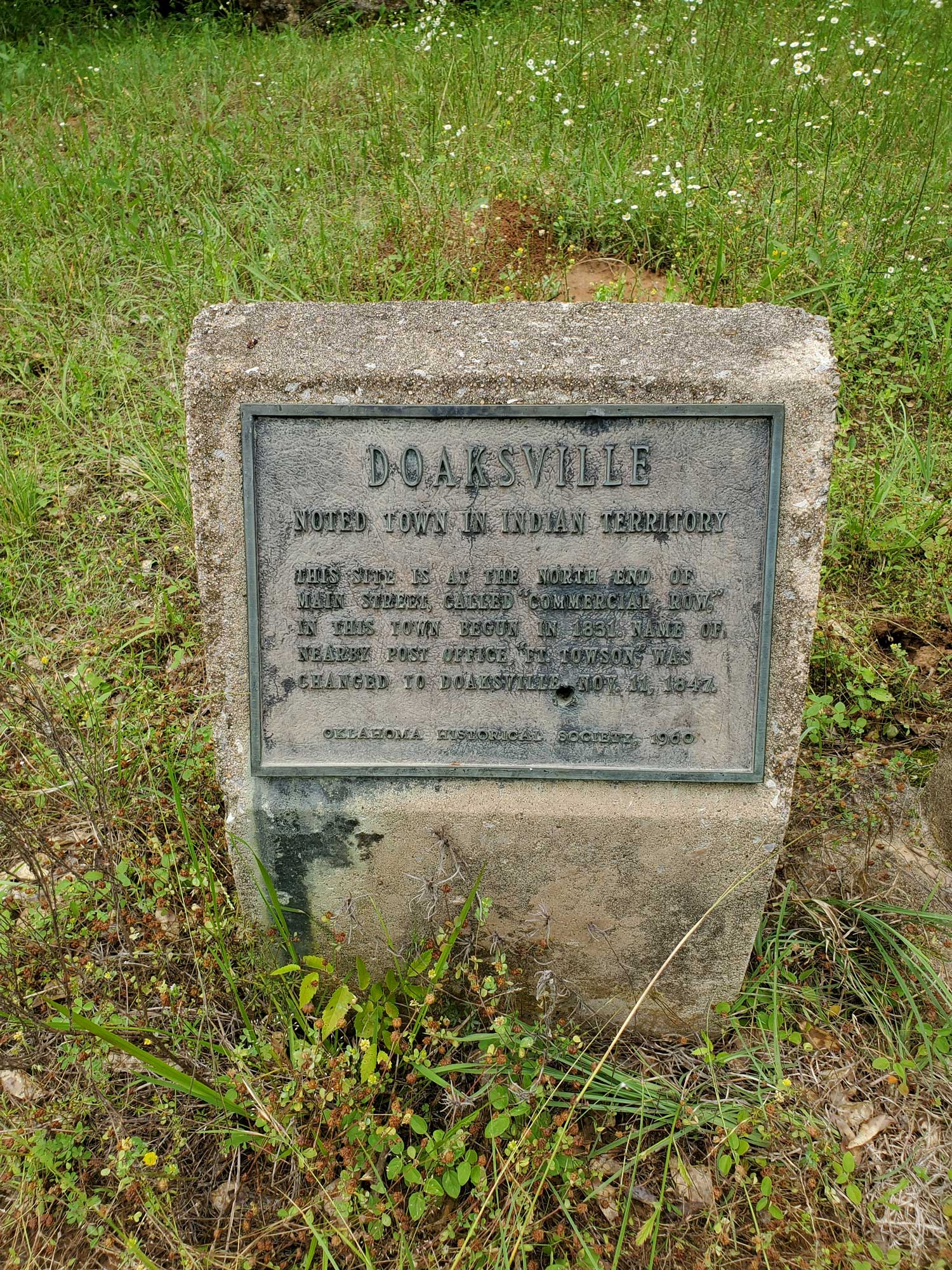
Doaksville
Choctaw CountyLocation: one mile north of Fort Towson on Red Road and east of Fort Towson Cemetery
Coordinates: 34.034867, -95.269867
Sponsored by: Oklahoma Historical Society
Material: Concrete with bronze plaque
Topics: Indian and Frontier Trade, Westward Expansion 1803–1861, American Indians, Settlement Patterns
This town was the commercial center of the region shortly after it was established by Josiah Doak in 1824. At one time it was the capital of the Choctaw Nation. The name of the post office at nearby Fort Towson was changed to Doaksville on November 11, 1847.
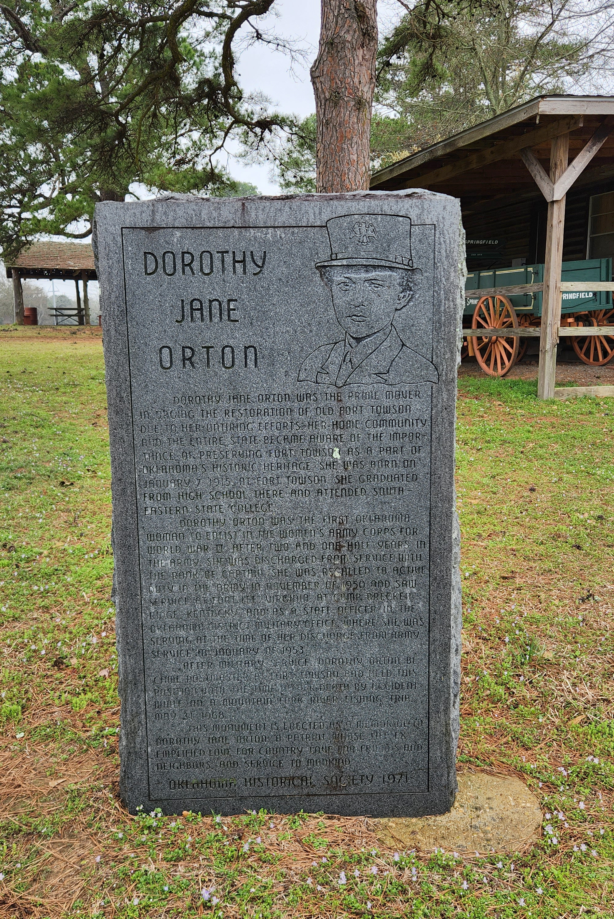
Dorothy Jean Orton
Choctaw CountyLocation: on grounds of Fort Towson Historic Site
Coordinates: 34.027830, -95.257074
Sponsored by: Oklahoma Historical Society
Material: Granite
Topics: Social/Cultural, Industrial Period 1941–1982, Military
Dorothy Jane Orton was the prime mover in urging the restoration of Old Fort Towson. Due to her untiring efforts her home community and the entire state became aware of the important of preserving Fort Towson as a part of Oklahoma's Historic Heritage. She was born on January 7, 1915 at Fort Towson she graduated from high school there and attended Southeastern State College. Dorothy Orton was the first Oklahoma woman to enlist in the Women's Army Corps for World War II. After two and one-half years in the army she was discharged from service with the rank of captain. She was recalled to active duty in the army in November of 1950 and saw service at Fort Lee, Virginia. At Camp Breckenridge, Kentucky and as a staff officer in the Oklahoma District Military Office, where she was serving at the time of her discharge from army service in January of 1953. After military service, Dorothy Orton became postmaster at Fort Towson and held this position until the time of her death by accident while on a Mountain Fork River Fishing Trip May 31, 1968.
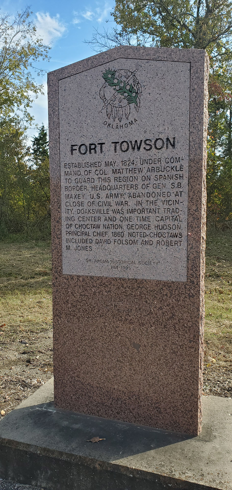
Fort Towson
Choctaw CountyLocation: on US-70 at east edge of Fort Towson
Coordinates: 34.017681, -95.253985
Sponsored by: Oklahoma Historical Society
Material: Granite
Topics: Military, Westward Expansion 1803–1861, American Indians, Government
Colonel Matthew Arbuckle ordered the construction of the fort in May 1824 to guard the US boundary with Mexico. After Indian removals to the area in the 1830s, the fort served as a permanent army post until 1854. During the Civil War, the fort was occupied by Confederate forces. Brigadier General Stand Watie surrendered his Confederate troops here in June 1865, the last Confederate general to lay down his arms. Fort Towson was abandoned after the Civil War.
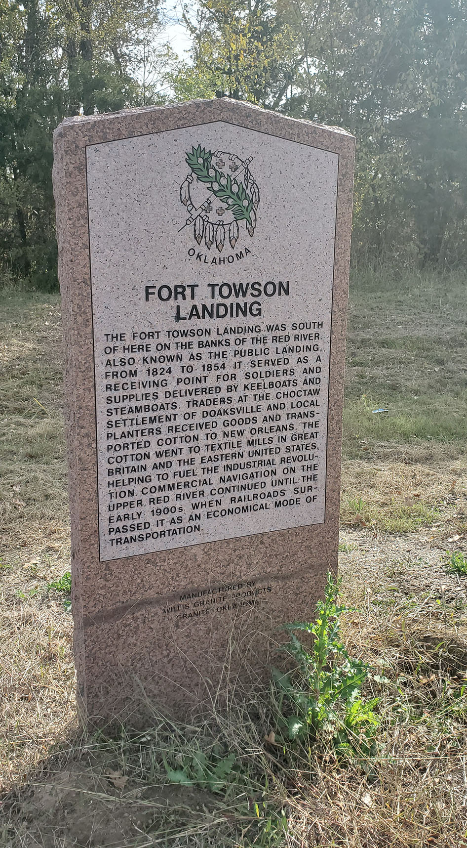
Fort Towson Landing
Choctaw CountyLocation: on US-70 at east edge of Fort Towson
Coordinates: 34.017682, -95.254016
Sponsored by: Oklahoma Historical Society and Oklahoma Department of Transportation
Topics: Industry/Business, Retail, Indian and Frontier Trade, American Indians, Transportation
The Fort Towson Landing was south of here on the banks of the Red River. Also known as the Public Landing, it served as a receiving point for soldiers and supplies delivered by keelboats and steamboats from 1824 to 1854. Traders at the Choctaw settlement of Doaksville and local planters received goods and transported cotton to New Orleans. The cotton went to textile mills in Great Britain and the eastern United States helping to fuel the Industrial Revolution. Commercial navigation on the Upper Red River continued until the early 1900s when railroads surpassed it an as economical mode of transportation.
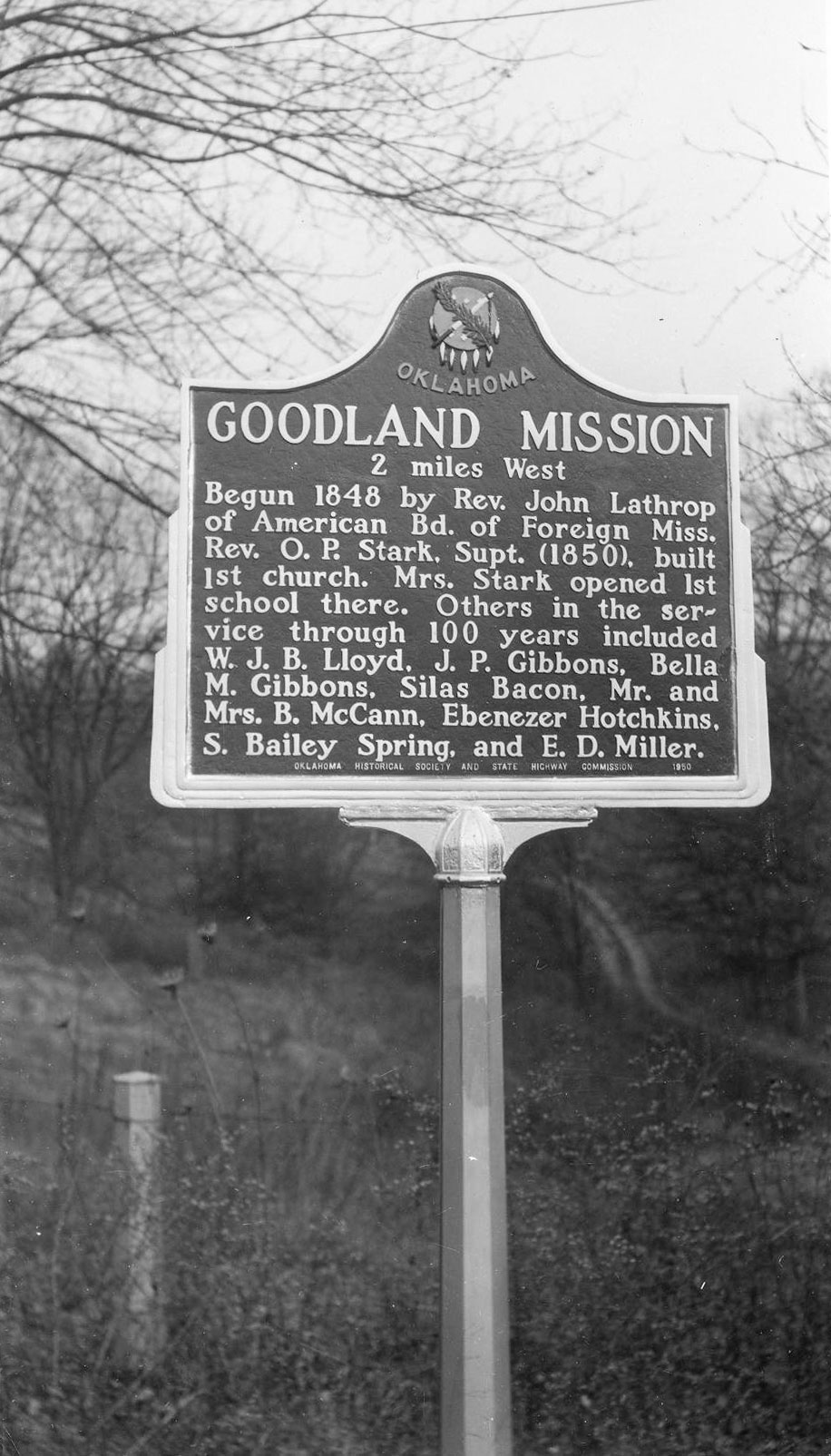
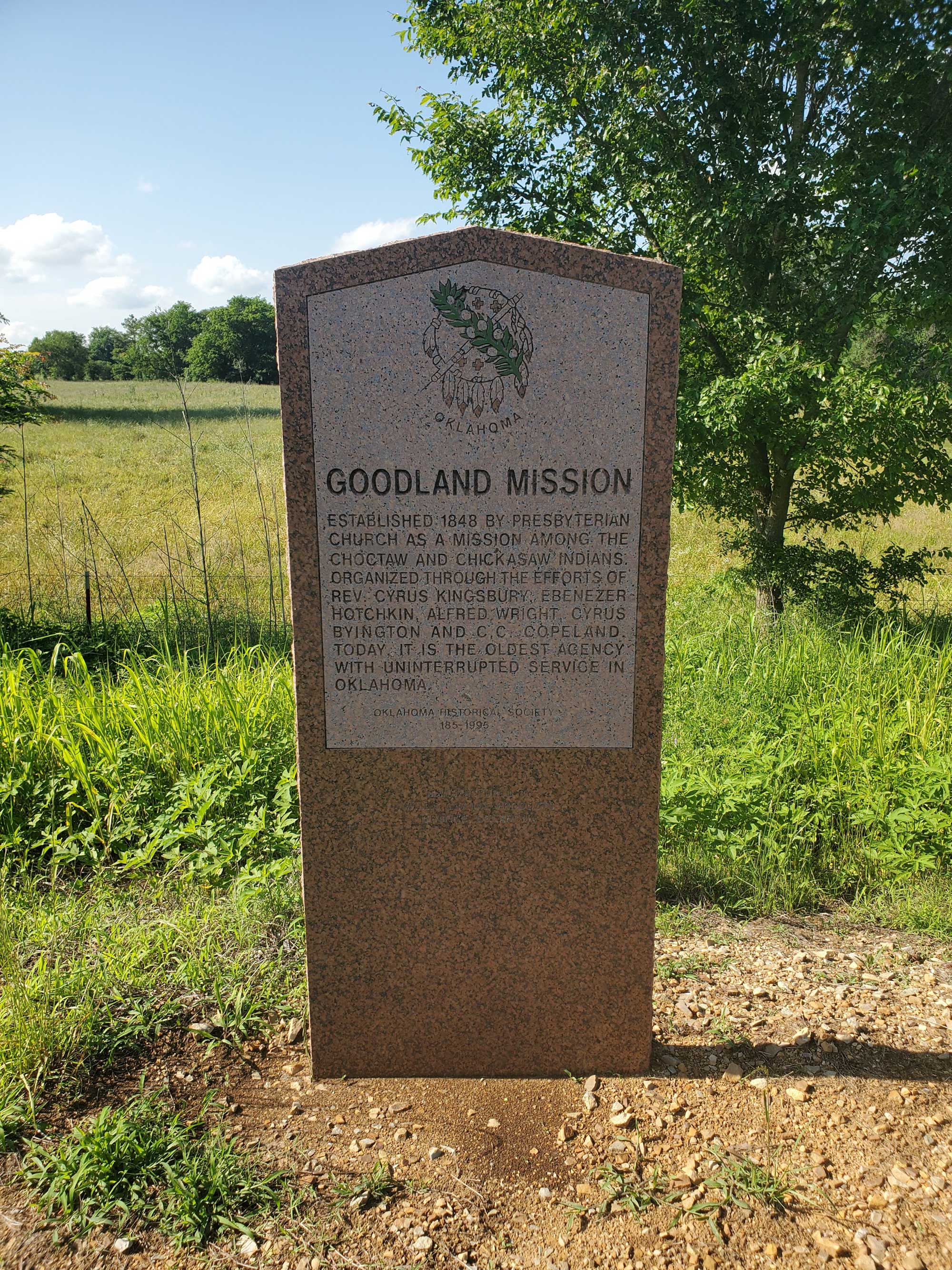
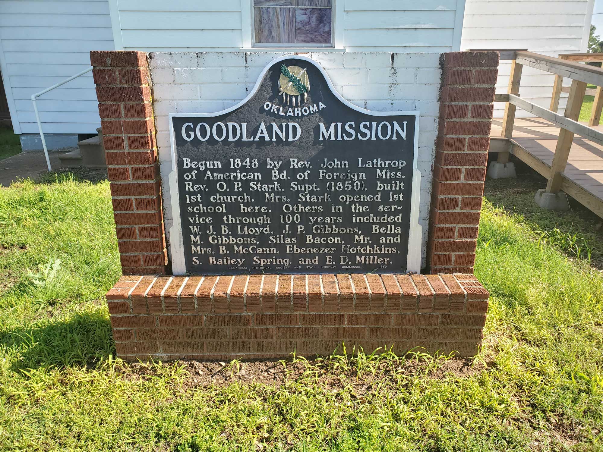
Goodland Mission
Choctaw CountyLocation: on OK 271A approximately two miles southwest of Hugo
Coordinates: 33.982754, -95.555325
Sponsored by: Oklahoma Historical Society and the Oklahoma Department of Transportation
Material: Granite
Topics: Religion/Philosophy, Education, Westward Expansion 1803–1861, Industrial 1941–1982, Modern Period 1982–present
Established in 1848 by the Presbyterian Church as a mission among the Choctaw and Chickasaw Indians. Orgnized through the efforts of Rev. Cyrus Kingsbury, Ebenezer Hotchkin, Alfred Wright, Cyrus Byington and C. C. Copeland. The first church and school were built in 1850. During the Civil War, Choctaw troops drilled on the campus for service in the Confederacy. The school returned to its primary mission of educating Indian youth after the war. Later, the mission school was called the Goodland Indian Orphanage, operated by the Southern Presbyterian Church. As the Goodland Presbyterian Children's Home since 1960, it is one of the oldest schools in continuous operation in Oklahoma. The current granite marker replaced an aluminum marker that can still be found on the Goodland Academy campus.

Goodwater Choctaw Mission
Choctaw CountyLocation: on US-70, one mile west of Kiamichi River bridge
Sponsored by: Oklahoma Historical Society and Oklahoma Department of Transportation
Material: Aluminum
Note: Marker is missing
Topics: Religion/Philosophy, Education, American Indians, Social/Cultural
In 1837, Reverend Ebenezer Hotchkins established the mission that became a Choctaw seminary for girls in 1842. The school closed at the beginning of the Civil War. Only the graves of the missionaries who served there mark the site.
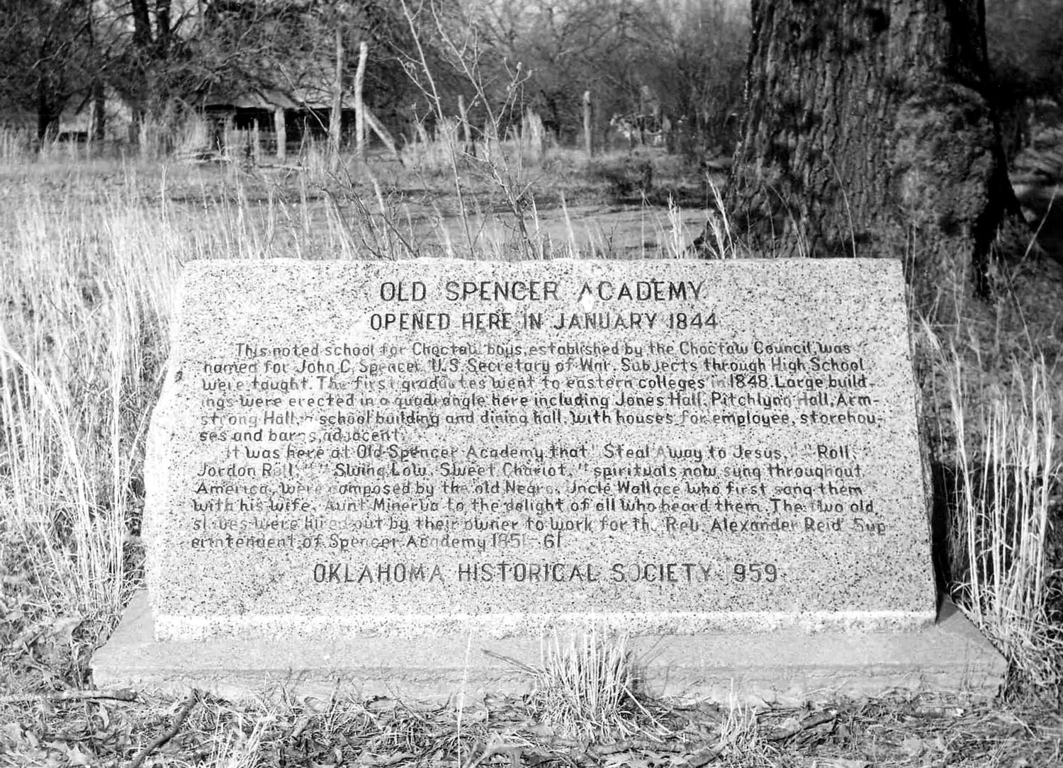
Old Spencer Academy
Choctaw CountyLocation: on grounds of old Spencer Academy, 8 miles north of Sawyer
Coordinates: 34.145919, -95.357897
Sponsored by: Oklahoma Historical Society
Material: Granite
Topics: Education, American Indians, Ethnic Diversity, Arts, Westward Expansion 1803–1861
Spencer Academy opened at this location in January 1844. This noted school for Choctaw boys, established by the Choctaw Council, was named for John C. Pencer, U.S. Secretary of War. Subjects through high school were taught. The first graduates went to eastern colleges in 1848. Large buildings were erected in a quadrangle here including Jones Hall, Pitchlynn Hall, Armstrong Hall, a school building and dining hall, with houses for employees, storehouses and barns adjacent. It was here that the spirituals "Steal Away to Jesus," Roll, Jordon Roll," and "Swing Low, Sweet Chariot" were composed. "Uncle Wallis" and "Aunt Minerva" Willis, spiritual composers, were enslaved in the Choctaw Nation and hired out by their owner to work for school superintendent Rev. Alexander Reid. Also see "Spencer Academy."
Pine Ridge Mission
Choctaw CountyLocation: on east side of Red Road 1/2 mile north of Doaksville/Fort Towson Cemetery
Sponsored by: Oklahoma Historical Society
Material: Unknown
Note: Unable to locate marker
Topics: Religion/Philosophy, Education, American Indians, Westward Expansion 1803–1861
The Presbyterian minister Reverend Cyrus Kingsbury established the Pine Ridge Mission in 1836. The Choctaw Council established a school for girls, Chuahla Female Seminary, at the mission in 1842, which Kingsbury supervised. The school was closed during the Civil War.
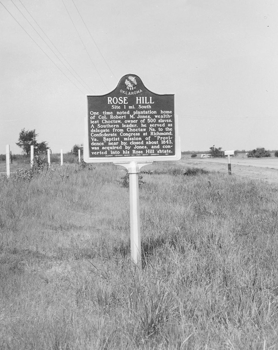
Rose Hill
Choctaw CountyLocation: on US-70, two miles east of Hugo
Sponsored by: Oklahoma Historical Society and the Oklahoma Department of Transportation
Material: Aluminum
Note: Marker reported missing
Topics: Family/Household, American Indians, Social/Cultural, Agriculture, Ethnic Diversity
Rose Hill, constructed before the Civil War, was the plantation home of Colonel Robert M. Jones, the wealthiest citizen of the Choctaw Nation. At one time, he owned 500 slaves to farm the land along the Red River. His mansion was decorated with crystal chandeliers imported from Europe. Rose Hill burned to the ground on Christmas night 1912. Only a row of massive cedar trees mark the site of the home today. Nearby, Jones is buried with his wife and children in a family cemetery.
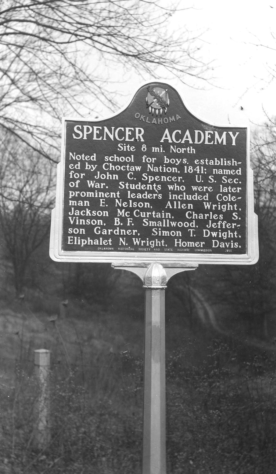
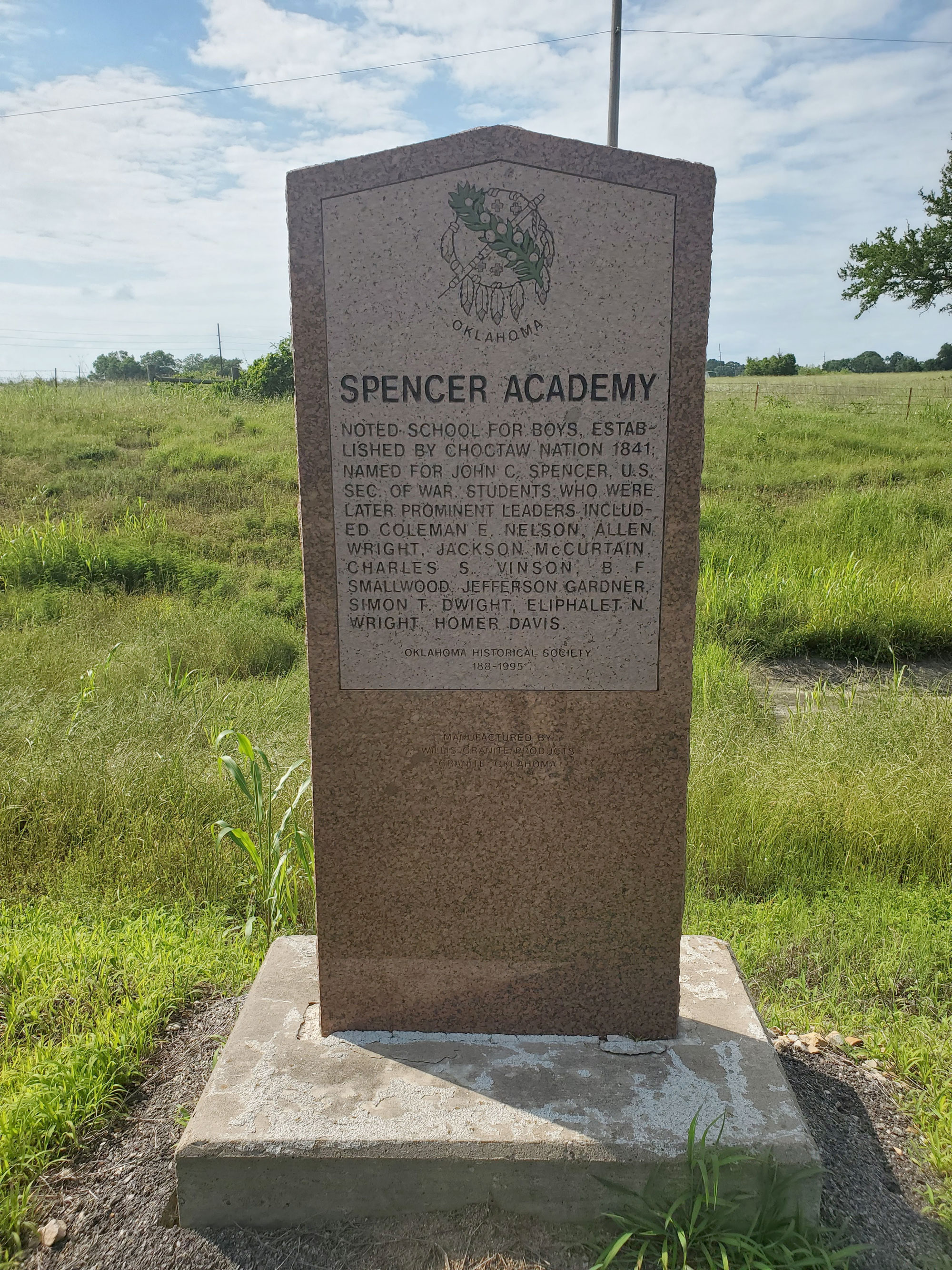
Spencer Academy
Choctaw CountyLocation: on US-70 east of Sawyer
Coordinates: 34.017945, -95.364481
Sponsored by: Oklahoma Historical Society and the Oklahoma Department of Transportation
Material: Granite
Topics: Education, American Indians, Ethnic Diversity, Arts, Westward Expansion 1803–1861
A noted school for boys, Spencer Academy was established by the Choctaw Nation in 1841 and named for Secretary of War John C. Spencer. Students who were later prominent Choctaw leaders included Coleman E. Nelson, Allen Wright, Jackson McCurtain, Charles S. Vinson, B. F. Smallwood, Jefferson Gardner, Simon T. Dwight, Eliphalet N. Wright, and Homer Davis.
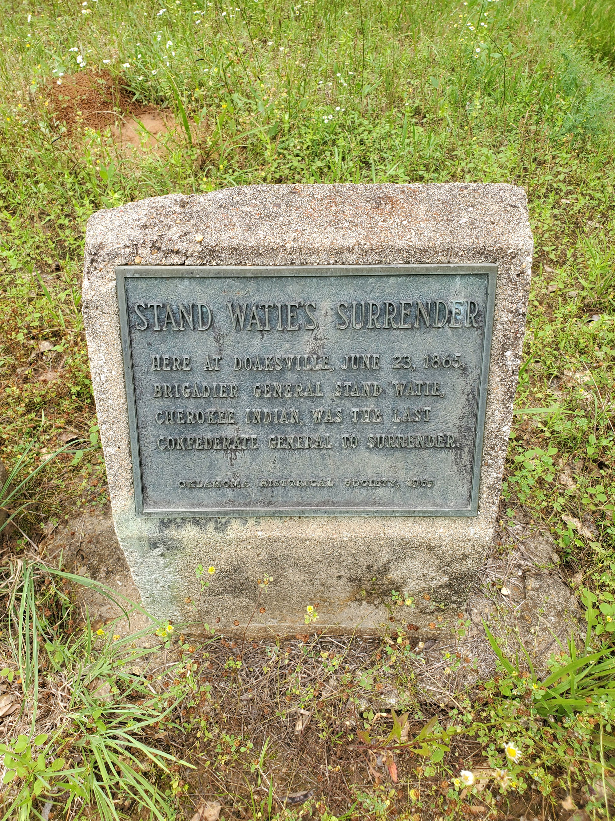
Stand Watie's Surrender
Choctaw CountyLocation: at Doaksville (one mile north of Fort Towson off Red Road; east of Fort Towson Cemetery)
Coordinates: 34.034867, -95.269867
Sponsored by: Oklahoma Historical Society
Material: Concrete with bronze plaque
Topics: Military, American Indians, Territorial Period 1861–1907
Here at Doaksville, June 23, 1865, Brigadier General Stand Watie, Cherokee Indian, was the last Confederate general to surrender.
Transportation Crossroads
Choctaw CountyLocation: on grounds of Fort Towson Historic Site
Coordinates: 34.027844, -95.257116
Sponsored by: Oklahoma Historical Society and the Oklahoma Department of Transportation
Material: Granite
Topics: Transportation, Military, Settlement Patterns, Social/Cultural, Folklife
During the early 1800s, present southeastern Oklahoma was a major transportation crossroads. Roads connected Fort Towson in the Choctaw Nation to military installations to the north, south, and west. On the Texas side of the Red River, Jonesboro was a major entry point for thousands headed for Austin's Colony and other settlements in Texas. Along these routes traveled such notable persons as General Zachary Taylor, Sam Houston, David Crockett, Jefferson Davis, and Benjamin Milan.
Search for Markers
Search by keyword or browse by county to learn about more than 700 historical markers created to recognize key locations, events, and people in Oklahoma history.
Please note that some markers listed in this database may have been moved, damaged, or are no longer standing.
Browse by County
Alfalfa County
Atoka County
Beaver County
Beckham County
Blaine County
Bryan County
Caddo County
Canadian County
Carter County
Cherokee County
Choctaw County
Cimarron County
Cleveland County
Comanche County
Cotton County
Craig County
Creek County
Custer County
Delaware County
Dewey County
Ellis County
Garfield County
Garvin County
Grady County
Grant County
Greer County
Harmon County
Harper County
Haskell County
Hughes County
Jackson County
Jefferson County
Johnston County
Kay County
Kingfisher County
Kiowa County
Le Flore County
Lincoln County
Logan County
Love County
Marshall County
Mayes County
McClain County
McCurtain County
McIntosh County
Murray County
Muskogee County
Noble County
Okfuskee County
Oklahoma County
Okmulgee County
Osage County
Ottawa County
Pawnee County
Payne County
Pittsburg County
Pontotoc County
Pottawatomie County
Pushmataha County
Roger Mills County
Rogers County
Seminole County
Sequoyah County
Stephens County
Texas County
Tillman County
Tulsa County
Wagoner County
Washington County
Washita County
Woods County
Woodward County
To find out more about the Oklahoma Historical Society Historical Marker Program or how to submit an application, please visit the Historical Marker Program page.
Missing or Damaged Markers
Please use our online form to report missing or damaged historical markers.
Report Missing or Damaged Markers
Contact Us
If you have questions, please contact:
Matthew Pearce
Oklahoma Historical Society
800 Nazih Zuhdi Drive
Oklahoma City, OK 73105
405-522-8659
matthew.pearce@history.ok.gov