Historical Marker Program
Search Results
Your search returned 7 results.
Clara Mae Luper
Okmulgee CountyLocation: on grounds of Grayson Town Hall and Community Center
Coordinates: 35.504761, -95.866354
Material: Granite
Sponsor(s): Town of Grayson
Topics: Civil Rights; Ethnic Diversity; Industrial Period, 1941–1982
Known as the mother of the Civil Rights Movement in Oklahoma, Clara Mae Luper was born in Okfuskee County, Oklahoma, on May 3, 1923. She grew up in Hoffman and graduated from Grayson High School. She was well known by many as a courageous schoolteacher, pioneering leader in the Civil Rights Movement, and a civic leader.

View image

View image
Creek Capitol/Creek Council House
Okmulgee CountyLocation: on the grounds of the historic Creek Council House in Okmulgee
Coordinates: 35.623040, -95.972120
Material: Various
Sponsor(s): Multiple sponsors
Topics: American Indians; Government; Territorial Period, 1861–1907
There are multiple markers at this location to commemorate Okmulgee as the capitol of the Muscogee (Creek) Nation. The stone Creek Council House building was constructed in 1878 and has since been restored to serve as a museum. The Okmulgee Constitution was written here in 1870. Sponsors of markers include the Daughters of the American Revolution, Oklahoma Historical Society, and Muscogee (Creek) Nation.

View image

View image
Grayson
Okmulgee CountyLocation: in community of Grayson
Topics: Early Statehood, 1907–1941; Ethnic Diversity; Land Openings; Settlement Patterns; Territorial Period, 1861–1907; Urban Development
Grayson is one of 13 All-Black towns, out of more than 50 that once existed, remaining in Oklahoma. While Tullahassee is reportedly the oldest, most were established between 1889 and 1907 as African Americans sought security and control of their own destiny in a segregated world. Most of the towns began to decline in the 1920s and 1930s as rural African Americans faced economic hardships and began to move to urban areas.
Nuyaka Mission
Okmulgee CountyLocation: on OK-56, nine miles west of Okmulgee
Coordinates: 35.624754, -96.149639
Material: Granite
Sponsor(s): Oklahoma Historical Society and the Oklahoma Department of Transportation
Topics: American Indians; Education; Government; Territorial Period, 1861–1907
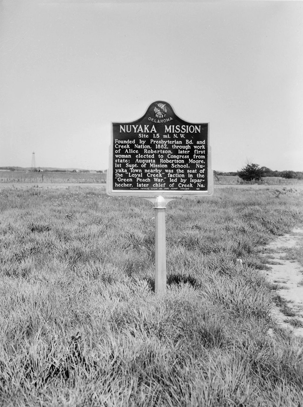
Nuyaka Mission was founded by the Presbyterian Board and the Muscogee (Creek) Nation in 1882 through the efforts of educator Alice Robertson, who also served as Oklahoma’s first female member of Congress. Augusta Robertson Moore was the first superintendent of the mission school. Nuyaka Town, located nearby, was the site of political violence and unrest during the Green Peach War of 1882.
View image

View image
Okmulgee Colored Hospital
Okmulgee CountyLocation: 210 N. Wood Dr. in Okmulgee
Coordinates: 35.625388, -95.960514
Material: Granite
Sponsor(s): Landmark for All Generations
Topics: Early Statehood, 1907–1941; Ethnic Diversity; Social/Cultural
In 1922, Okmulgee’s Black citizens secured $25,000 in donations to fund construction of the first "colored hospital" to be opened in the state of Oklahoma. Black citizens formed the Colored Hospital Association in 1924. The hospital housed 18–20 beds with living quarters for a staff of six to seven nurses. It closed in 1957 when Okmulgee integrated its health facilities. The building was listed in the National Register of Historic Places in 1984.

View image
Samuel Checote
Okmulgee CountyLocation: on grounds of historic Creek Council House in Okmulgee
Coordinates: 35.623072, -95.972344
Material: Aluminum
Sponsor(s): Creek Indian Memorial Association and the Oklahoma Historical Society
Topics: American Indians; Military; Religion/Philosophy; Westward Expansion, 1803–1861
Samuel Checote spent much of his life serving as a Methodist minister. During the Civil War he was a lieutenant colonel of the First Regiment of Creek Mounted Volunteers. He was elected principal chief of the Muscogee (Creek) Nation in 1867.

View image
Trail of Tears
Okmulgee CountyLocation: on grounds of historic Creek Council House in Okmulgee
Coordinates: 35.622549, -95.972145
Material: Aluminum
Sponsor(s): Alabama Tennessee Trail of Tears Corridor Association, Inc.
Topics: American Indians; Military; Westward Expansion, 1803–1861
During 1836-37, the US government forcibly removed about 14,000 Muscogees (Creeks) from Alabama and Georgia to Indian Territory. They were marched under harsh conditions, resulting in the deaths of about 4,000 individuals. All routes for removal ended at Fort Gibson, where the Creeks then moved into the current Muscogee (Creek) Nation boundaries.

View image
(Page 1 of 1)
Marker Search
Use quotation marks to search for an exact phrase.
Browse by County
Adair County
Alfalfa County
Atoka County
Beaver County
Beckham County
Blaine County
Bryan County
Caddo County
Canadian County
Carter County
Cherokee County
Choctaw County
Cimarron County
Cleveland County
Comanche County
Cotton County
Craig County
Creek County
Custer County
Delaware County
Dewey County
Ellis County
Garfield County
Garvin County
Grady County
Grant County
Greer County
Harmon County
Harper County
Haskell County
Hughes County
Jackson County
Jefferson County
Johnston County
Kay County
Kingfisher County
Kiowa County
Latimer County
Le Flore County
Lincoln County
Logan County
Love County
Major County
Marshall County
Mayes County
McClain County
McCurtain County
McIntosh County
Murray County
Muskogee County
Noble County
Nowata County
Okfuskee County
Oklahoma County
Okmulgee County
Osage County
Ottawa County
Pawnee County
Payne County
Pittsburg County
Pontotoc County
Pottawatomie County
Pushmataha County
Roger Mills County
Rogers County
Seminole County
Sequoyah County
Stephens County
Texas County
Tillman County
Tulsa County
Wagoner County
Washington County
Washita County
Woods County
Woodward County
To find out more about the Oklahoma Historical Society Historical Marker Program or how to submit an application, please visit the Historical Marker Program page.
Missing or Damaged Markers
Please use our online form to report missing or damaged historical markers.
Report Missing or Damaged Markers
Contact Us
If you have questions, please contact:
Matthew Pearce
Oklahoma Historical Society
800 Nazih Zuhdi Drive
Oklahoma City, OK 73105
405-522-8659
[email protected]