
Historical Marker Program
Search Results
Your search returned 9 results.
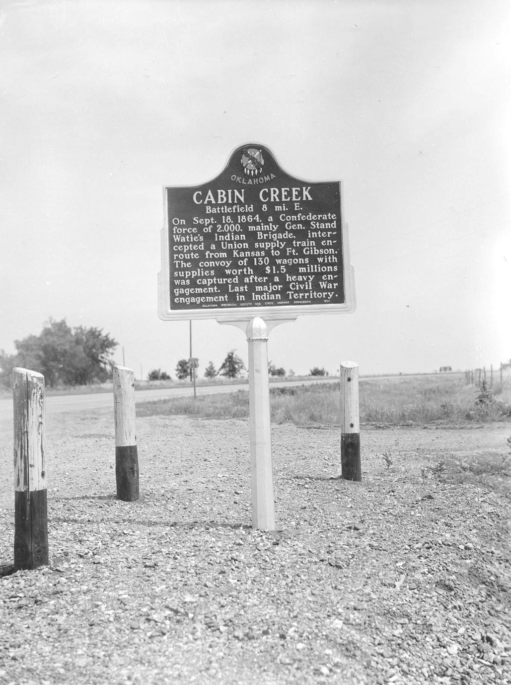
Battle of Cabin Creek
Mayes CountyLocation: on US-69, one mile south of Craig-Mayes County line
Topics: Military, Government, Territorial Period 1861–1907, American Indians, Transportation
The first Battle of Cabin Creek was fought July 1 and 2, 1863, where Cabin Creek crossed the old Fort Gibson Military Road. The second battle occurred September 18, 1864, when 2,000 Confederate troops under Brigadier General Stand Watie captured a 130-wagon federal supply train carrying $1.5 million in goods. This was the last major Civil War engagement in Indian Territory.
Battle of Locust Grove
Mayes CountyLocation: on OK-33 on east side of Locust Grove in parkway at "Pipe Spring," SH 33
Material: Aluminum
Topics: Military, Government, American Indians, Social/Cultural, Transportation
On July 2, 1862, federal troops under Colonel William Weer surprised a Confederate encampment here. The Southerners led by Colonel J. J. Clarkson surrendered, but heavy fighting continued throughout the day in nearby woods between Union troops and Confederate soldiers who escaped the raid.
Cabin Creek Battlefield
Mayes CountyLocation: on US-69 north of Patton
Material: Aluminum
Topics: Military
Emplacements can still be seen where cannons were set to defend the crossing of Cabin Creek. There are many unmarked graves of soldiers who died when General Stand Watie's Confederate troops captured a Federal supply train on September 18, 1864. Earlier, in July 1863, the Confederates were defeated in a small skirmish here.
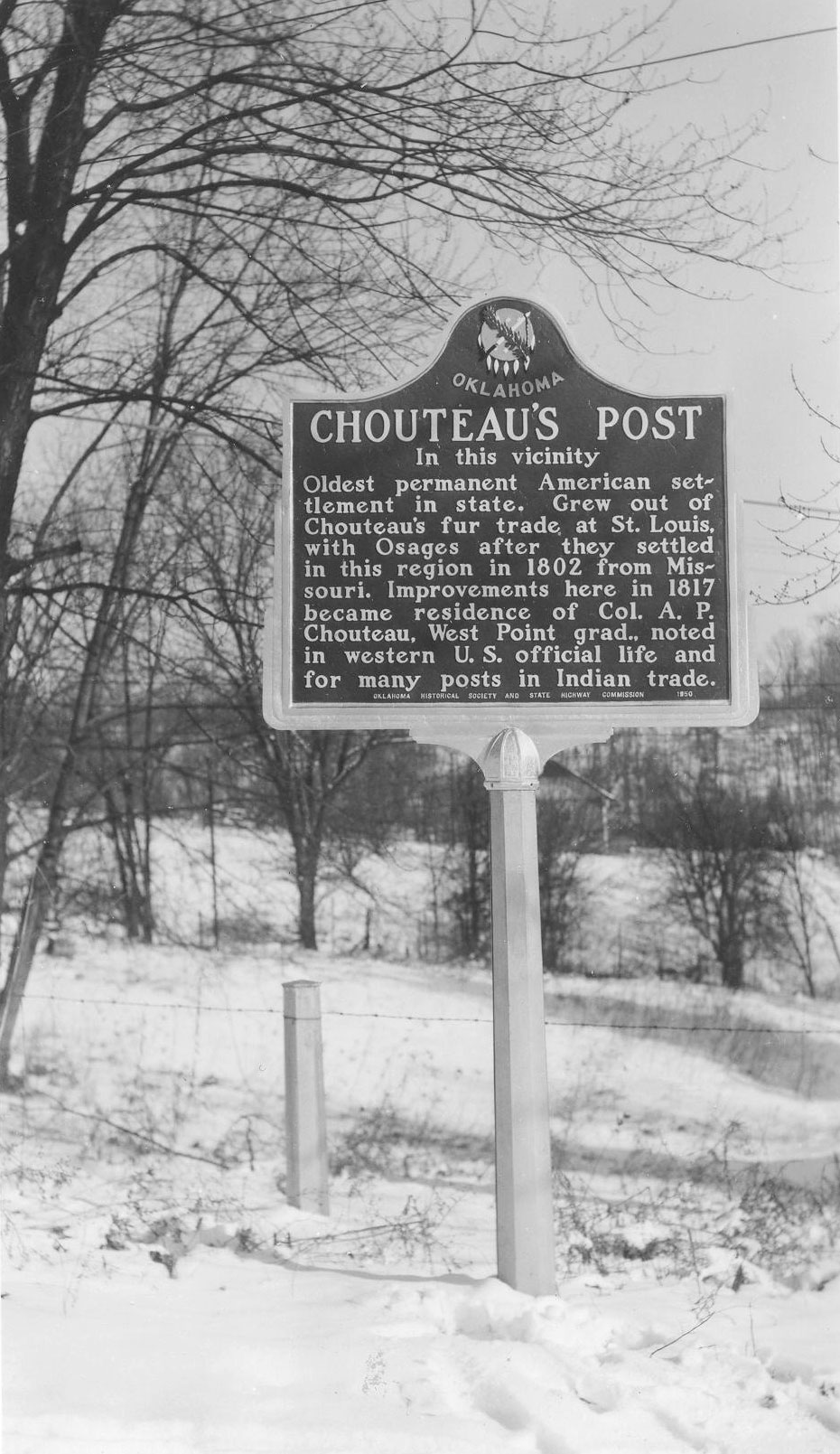
Chouteau's Post
Mayes CountyLocation: on public school grounds in Salina
Topics: Indian and Frontier Trade, Westward Expansion 1803–1861, American Indians, Settlement Patterns, Military
Auguste Chouteau and his brother, Pierre, traded with the Arkansas band of Osage in the Three Forks area where the Arkansas, Verdigris, and Grand Rivers merge. Colonel A. P. Chouteau—Pierre's son and the fourteenth man to graduate from the US Military Academy at West Point— built a trading post on the Grand River in 1817, recognized as the oldest permanent American settlement in what became Oklahoma. He built a home near the trading post on the eastern bank of the Grand River.
Jean Pierre Chouteau Bridge
Mayes CountyLocation: on US-69 at edge of Salina
Topics: Indian and Frontier Trade, American Indians
The Chouteau family had extensive holdings which included salt works and trading posts. Jean Pierre and his brother, Auguste, from a base in St. Louis, Missouri, traded with Osages in the area.
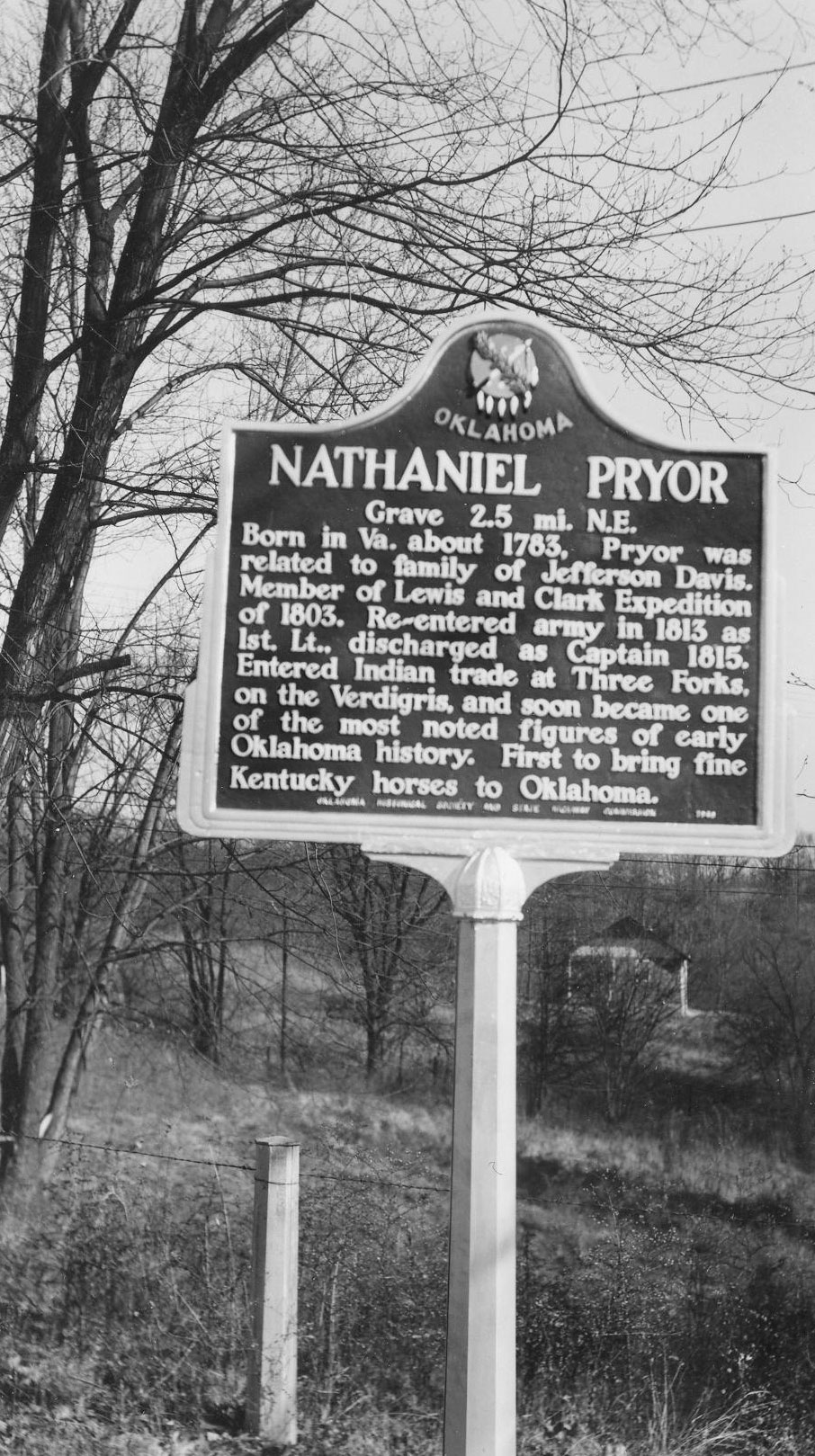
Nathaniel Pryor
Mayes CountyLocation: on US-64, four miles south of Pryor
Topics: Military, Social/Cultural, Indian and Frontier Trade, Ranching
Born in Virginia about 1783, Nathaniel Pryor was related to family of Jefferson Davis and a member of the Lewis and Clark Expedition of 1803. He re-entered the army in 1813 as a 1st Lieutenant and discharged as Captain in 1815. Pryor entered into Indian trade at Three Forks on the Verdigris and soon became one of the most noted figures of early Oklahoma history. He was the first to bring fine Kentucky horses to Oklahoma.
Salina
Mayes CountyLocation: at Salina High School
Topics: Folklife, Early Statehood 1907–1941, Social/Cultural, Education
A large monument erected in 1916 to commemorate Oklahoma's first white settlement was used as a cornerstone during construction of Salina High School.
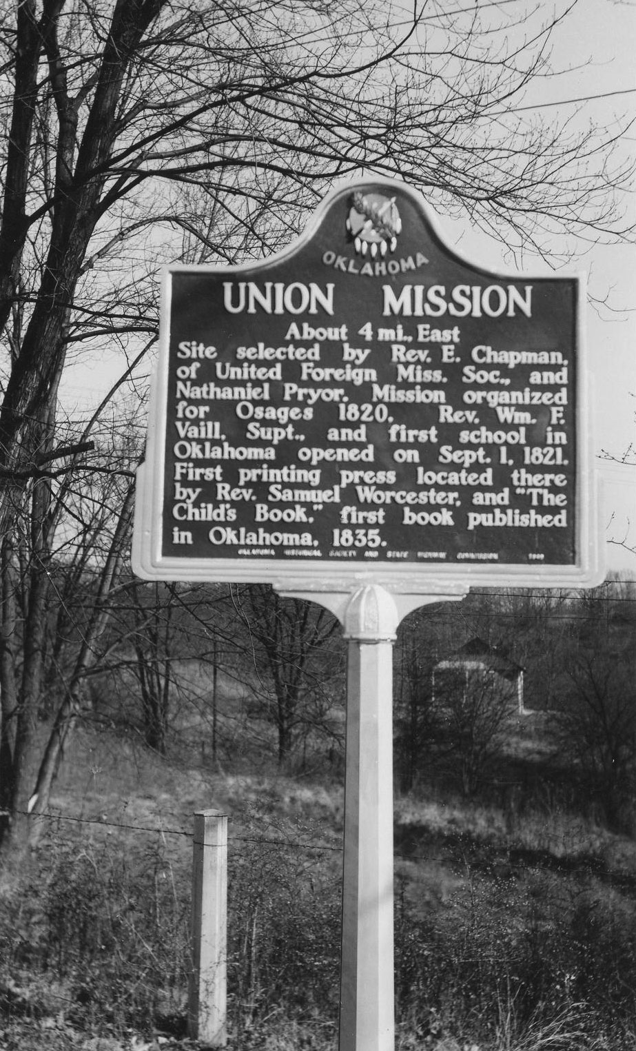
Union Mission
Mayes CountyLocation: on US-69, two miles of Chouteau
Material: Aluminum
Topics: American Indians, Education, Religion/Philosophy, Westward Expansion 1803–1861, Social/Cultural
The mission was organized for the Osage in 1820 and the future state's first school opened for classes on September 1, 1821. On the grounds is what is believed to be the oldest marked grave in Oklahoma, that of Reverend Epaphras Chapman, a victim of typhus on June 7, 1825. The first printing press in present-day Oklahoma was located at Union Mission.
Union Mission
Mayes CountyLocation: inside Union Mission Cemetery south of Chouteau south of Mazie Landing Road (DAR)
Sponsored by: Daughters of the American Revolution
Material: Granite
Topics: Social/Cultural, Religion/Philosophy, Education, Westward Expansion 1803–1861
This is the burial ground of members of missionary families who died at Union Mission from 1822 to 1825. The mission was a pioneer institution, the site of the state's first church and school.
Search for Markers
Search by keyword or browse by county to learn about more than 600 historical markers created to recognize key locations, events, and people in Oklahoma history.
Please note that some markers listed in this database may have been moved, damaged, or are no longer standing.
Browse by County
Alfalfa County
Atoka County
Beaver County
Beckham County
Blaine County
Bryan County
Caddo County
Canadian County
Carter County
Cherokee County
Choctaw County
Cimarron County
Cleveland County
Comanche County
Cotton County
Craig County
Creek County
Custer County
Delaware County
Dewey County
Ellis County
Garfield County
Garvin County
Grady County
Grant County
Greer County
Harmon County
Harper County
Haskell County
Hughes County
Jackson County
Jefferson County
Johnston County
Kay County
Kingfisher County
Kiowa County
Le Flore County
Lincoln County
Logan County
Love County
Marshall County
Mayes County
McClain County
McCurtain County
McIntosh County
Murray County
Muskogee County
Noble County
Okfuskee County
Oklahoma County
Okmulgee County
Osage County
Ottawa County
Pawnee County
Payne County
Pittsburg County
Pontotoc County
Pottawatomie County
Pushmataha County
Roger Mills County
Rogers County
Seminole County
Sequoyah County
Stephens County
Texas County
Tillman County
Tulsa County
Wagoner County
Washington County
Washita County
Woods County
Woodward County
To find out more about the Oklahoma Historical Society Historical Marker Program or how to submit an application, please visit the Historical Marker Program page.
Missing or Damaged Markers
Please use our online form to report missing or damaged historical markers.
Report Missing or Damaged Markers
Contact Us
If you have questions, please contact:
Matthew Pearce
Oklahoma Historical Society
800 Nazih Zuhdi Drive
Oklahoma City, OK 73105
405-522-8659
matthew.pearce@history.ok.gov