
Historical Marker Program
Search Results
Your search returned 10 results.
Atlas F Intercontinental Ballistic Missile Site
Greer CountyLocation: Beside OK Highway 34/U.S. Highway 283, immediately west of the Willow missile site. Willow, OK
Material: Aluminum
To counter the Soviet Union's Cold War nuclear threat in the 1950s, the United States government created the Atlas Intercontinental Ballistic Missile. Twelve Atlas F Missile sites were built near Altus Air Force Base between 1960 and 1962. One of these sites sat immediately east of this marker.
The underground silo that housed the 82-foot-long missile here was 174 feet deep with a diameter of 52 feet. Connected to the missile silo by a tunnel was the underground Launch Control Center. A five-person crew lived there around the clock, ready to fire the missile. Once fired, the Atlas stored here was capable of reaching the Soviet Union in 43 minutes.
This missile site was attached to the 577th Strategic Missile Squadron at Altus Air Force Base. All 12 Altus-area missiles were put on alert during the October 1962 Cuban Missile Crisis. On March 25, 1965, the 577th SMS was inactivated.
The Atlas Missile program was a national security priority under Presidents Eisenhower, Kennedy and Johnson. The Willow Atlas Missile site played a crucial role in the nation's Cold War nuclear arsenal from 1962 to 1965.
This marker provided by the CHARLES T. and MARY ELLEN DOYLE FAMILY.
The Battle of Saint Etienne France by the Infantry Division on October 8, 1918
Greer CountyLocation: Veterans Park 410 N. Main, Granite OK
Material: Aluminum
Topics: Early Statehood, 1907–1941; Government; Military
The 36th Infantry Division was organized by combining the Oklahoma and Texas National Guards. Sixty men that volunteered from Old Greer County were kept together and placed in the 132nd Machine Gun Battalion in that Division. On October 8th, 1918, these men fought on Hill 140 at Saint Etienne France. The Division suffered 1,300 casualties in the first day of fighting, which was the single day highest casualty rate of the war. After three days of heavy fighting, the enemy began to retreat, and one month later, the war came to an end on November 11, 1918.
Fifty-five other men from Old Greer County fought in the same battle with the 141st and 142nd Infantry Regiments of the 36th Division. One of these soldiers, Sergeant Samuel Sampler from Mangum, received the Medal of Honor for his action on Hill 140 as he fought alongside his fellow Doughboys from Southwest Oklahoma. These men were from Granite, Mangum, Blake, Reed, Willow, Duke, Eldorado, Gould, Hollis, Victory, Vinson, Blair, Altus, Elmer, Headrick, Martha, Olustee and Delhi.
This marker is dedicated on the Centennial of this historic World War I battle by American Legion Post 121 from Mangum and the City of Granite.
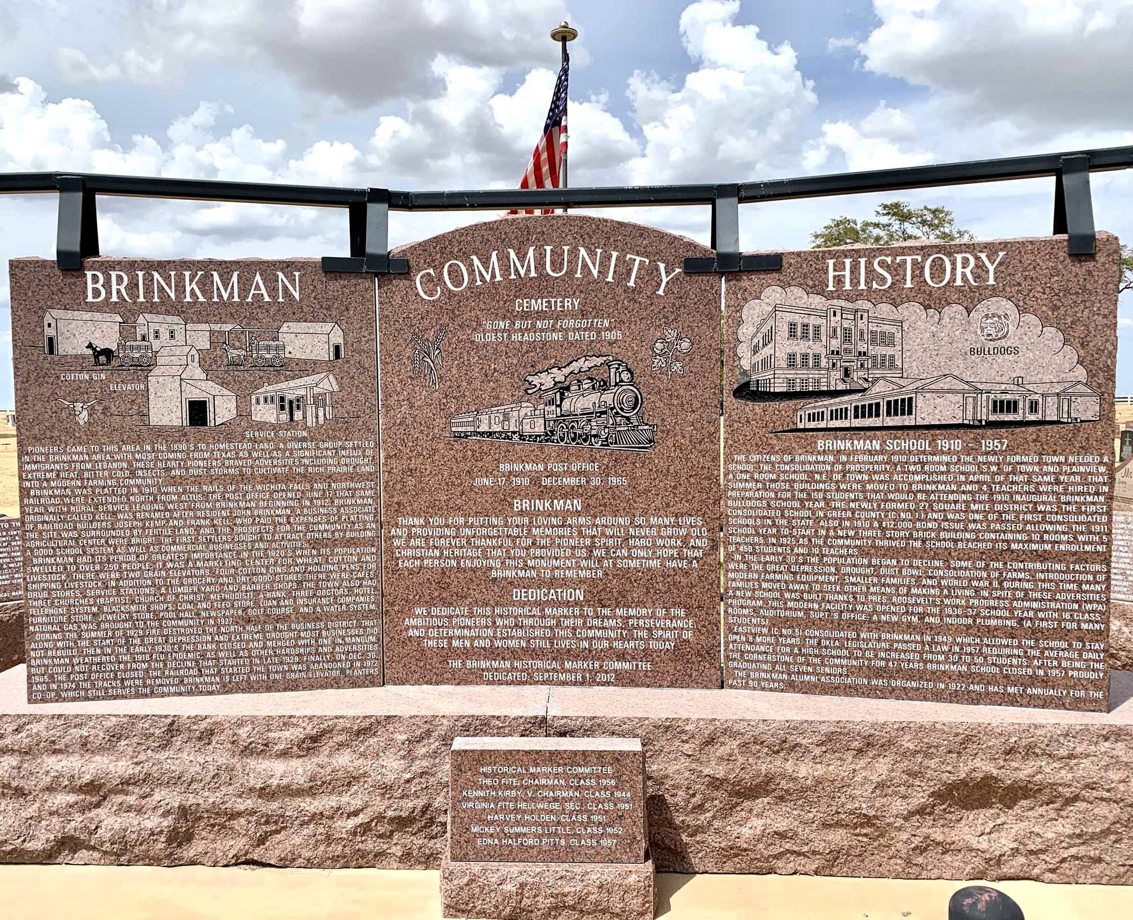
Brinkman
Greer CountyLocation: one mile west of US-283 on E1380 Rd in Brinkman Cemetery
Coordinates: 35.016636, -99.509926
Material: Granite
Sponsor(s): Brinkman Historical Marker Committee
Topics: Agriculture ; Early Statehood, 1907–1941; Ethnic Diversity; Settlement Patterns
Settlers from Texas and immigrants from Lebanon began homesteading in the area in the 1890s. The town of Brinkman was platted in 1910 upon the arrival of the Wichita Falls and Northwest Railroad. Originally known as Kell, the town was renamed after resident John Brinkman. The town’s population peaked in the 1920s as a marketing center for wheat, cotton, and livestock. The combination of a devastating fire in 1929, the Great Depression, and drought prompted a significant decline in the town’s fortunes. Brinkman School closed in 1957, followed by the post office in 1965. A single grain elevator continues to serve the community today.
First Shelterbelt
Greer CountyLocation: on OK-34A southeast of Willow
Topics: Agriculture; Early Statehood, 1907–1941; Environmental/Cultural Ecology; Government
As part of President Franklin D. Roosevelt's program to stabilize blowing topsoil in the Dust Bowl, the Prairie States Forestry Project coordinated the planting of wide belts of trees from North Dakota to Texas. The first shelterbelt in the nation was planted on the H. E. Curtis farm near Mangum on March 18, 1935. For the next seven years more than 18,000 miles of shelterbelts were planted, including nearly 3,000 miles in Oklahoma.
Giants of the Great Plains
Greer CountyLocation: in Granite, Oklahoma only 38 minutes south of Elk City or 30 minutes north of Altus
Material: Granite
Topics: American Indians; Arts; Early Statehood, 1907–1941; Social/Cultural
Will Rogers (face, 30' wide and 28' tall) was dedicated November 10, 1979, in recognition of Rogers' 100th birthday anniversary. This giant mosaic is comprised of 195 two-foot-square granite panels.
Lake Creek
Greer CountyLocation: on county road, two miles west of OK-6 north of Granite
Material: Granite
Topics: Agriculture; Education; Environmental/Cultural Ecology; Ethnic Diversity; Government; Religion/Philosophy; Settlement Patterns; Territorial Period, 1861–1907; Transportation
Pioneers settled the Lake Creek area beginning in 1898. The consolidated Lake Creek School served area children until 1957. The community included the oldest church in Greer County, the Lake Creek Baptist Church, founded in 1888.
Lugert
Greer CountyLocation: on OK-44 near Lugert grain elevator
Frank Lugert, an Austrian immigrant, ran the post office, train depot, and general store in the town he founded after the Kiowa-Comanche-Apache Reservation opened for settlement in 1901. The town thrived until it was destroyed by a tornado in 1912. The original townsite is now covered by the waters of Lake Altus-Lugert.
Old Greer County
Greer CountyLocation: on courthouse grounds in Mangum
Material: Granite
Topics: Government; Territorial Period, 1861–1907
The North Fork of the Red River was originally the northern boundary of Spanish territory after the Louisiana Purchase of 1803. The area between the North Fork and the main stream of the Red River became Greer County, Texas. However, in 1896, the US Supreme Court ruled that the main branch of the river was the northern boundary of Texas and Old Greer County became part of Oklahoma Territory.
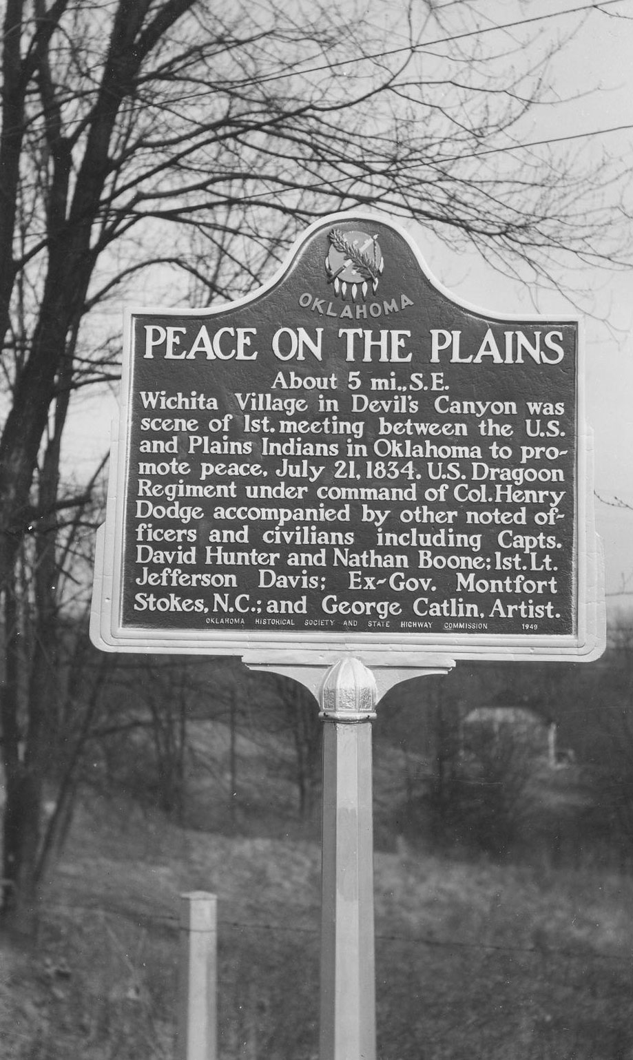
Peace on the Plains
Greer CountyLocation: at junction of OK-44 and old US-283 near Quartz Mountain State Park
Coordinates: 34.856531, -99.330696
Material: Aluminum
Sponsor(s): Oklahoma Historical Society and the Oklahoma Department of Tourism
Topics: American Indians; Military; Westward Expansion, 1803–1861
A Wichita village approximately 5 miles southeast of this marker’s location was the scene of the first meeting between the federal government and Indian tribes of the western Great Plains in present-day Oklahoma on July 21, 1834. The US Dragoon regiment, under the command of Colonel Henry Dodge, camped one mile away from the village, which contained more than 200 grass lodges. Noted officers and civilians who accompanied the dragoons included Captains David Hunter and Nathan Boone, First Lieutenant Jefferson Davis, former North Carolina governor Montfort Stokes, and artist George Catlin.
Note: This marker has been reported for containing inaccurate language. Dragoons under the command of Colonel Dodge first encountered a Comanche village on July 14, 1834. Colonel Dodge was unable to arrange negotiations due to the Comanche chief being away, so the expedition moved westward and encountered a Wichita village on July 21. Formal negotiations between the US government and the Wichita commenced on July 22. Negotiations with the Kiowa and Comanche began the following day. Also see Camp Comanche (Caddo County).

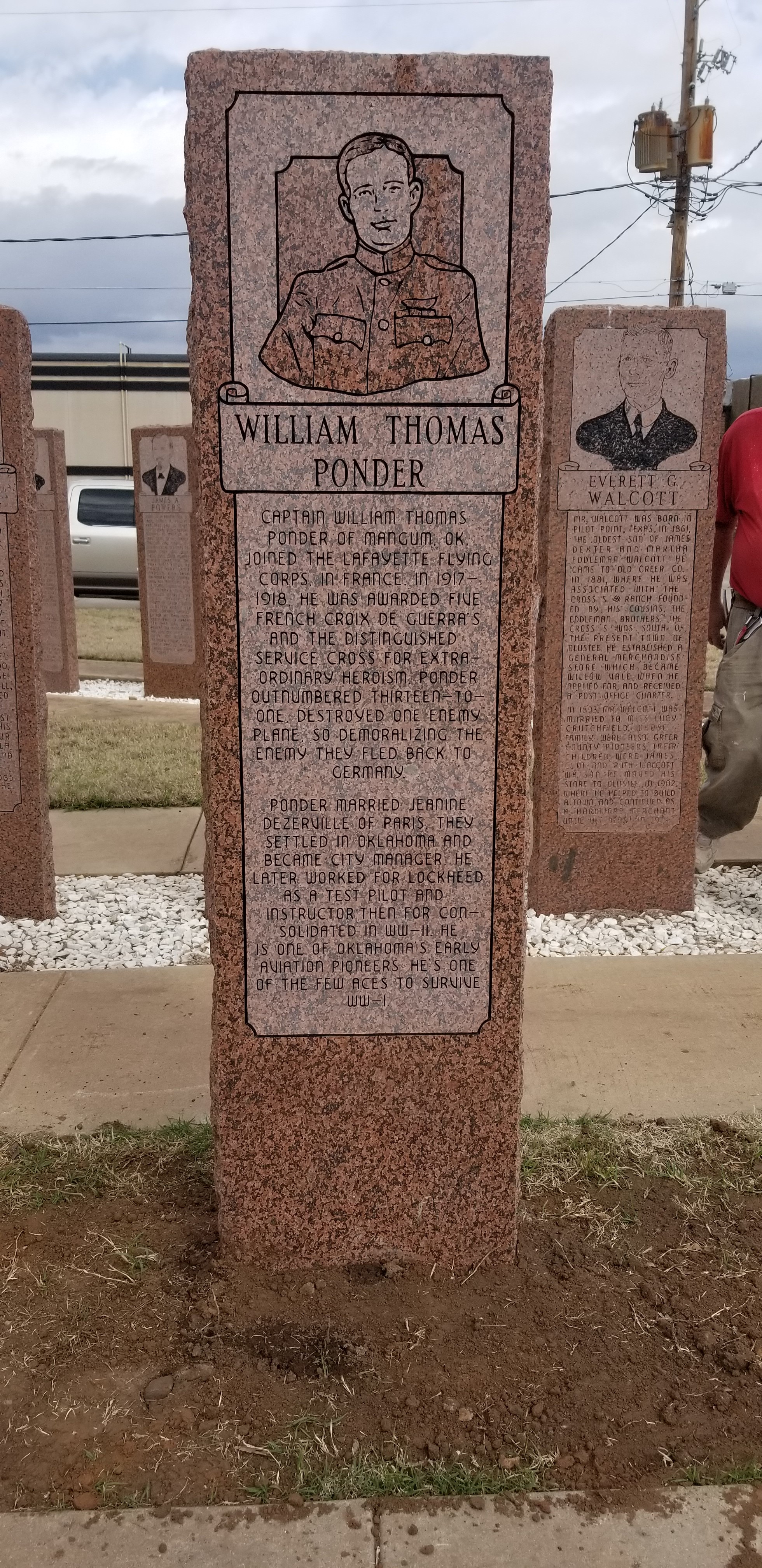
William Ponder
Greer CountyLocation: on the grounds of the Old Greer County Museum and Hall of Fame, 222 W. Jefferson, Mangum, OK
Coordinates: 34.873322, -99.507031
Material: Granite
Topics: Early Statehood, 1907–1941; Industry/Business; Military
Captain William Thomas Ponder of Mangum, OK joined the Lafayette Flying Corps in France in 1917-1918. He was awarded five French Croix de Guerras and the Distinguished Service Cross for extraordinary heroism. Ponder outnumbered thirteen to one, destroyed one enemy plane, so demoralizing the enemy they fled back to Germany. Ponder married Jeanine Dezerville of Paris. They settled in Oklahoma and he became city manager. He later worked for Lockheed as a test pilot and instructor. He is one of the few aces to survive WWI.
(Page 1 of 1)
Search for Markers
Search by marker name or browse by county or subject to learn about more than 700 historical markers recognizing key locations, events, and people in Oklahoma history.
This database contains markers sponsored by the Oklahoma Historical Society and markers created by other organizations. Please note that some markers listed may have been relocated, damaged, or no longer exist.
Browse by County
Alfalfa County
Atoka County
Beaver County
Beckham County
Blaine County
Bryan County
Caddo County
Canadian County
Carter County
Cherokee County
Choctaw County
Cimarron County
Cleveland County
Comanche County
Cotton County
Craig County
Creek County
Custer County
Delaware County
Dewey County
Ellis County
Garfield County
Garvin County
Grady County
Grant County
Greer County
Harmon County
Harper County
Haskell County
Hughes County
Jackson County
Jefferson County
Johnston County
Kay County
Kingfisher County
Kiowa County
Latimer County
Lincoln County
Logan County
Love County
Major County
Marshall County
Mayes County
McClain County
McCurtain County
McIntosh County
Murray County
Muskogee County
Noble County
Okfuskee County
Oklahoma County
Okmulgee County
Osage County
Ottawa County
Pawnee County
Payne County
Pittsburg County
Pontotoc County
Pottawatomie County
Pushmataha County
Roger Mills County
Rogers County
Seminole County
Sequoyah County
Stephens County
Texas County
Tillman County
Tulsa County
Wagoner County
Washington County
Washita County
Woods County
Woodward County
To find out more about the Oklahoma Historical Society Historical Marker Program or how to submit an application, please visit the Historical Marker Program page.
Missing or Damaged Markers
Please use our online form to report missing or damaged historical markers.
Report Missing or Damaged Markers
Contact Us
If you have questions, please contact:
Matthew Pearce
Oklahoma Historical Society
800 Nazih Zuhdi Drive
Oklahoma City, OK 73105
405-522-8659
matthew.pearce@history.ok.gov