
Historical Marker Program
Search Results
Your search returned 13 results.
Canute
Washita CountyLocation: on I-40 in Canute
Material: Granite
Topics: Urban Development, Government, Territorial Period 1861–1907
Initially called Oak, this town was named for the king of Denmark. The first post office was established on February 24, 1899.
Cloud Creek
Washita CountyLocation: on county courthouse grounds in Cordell
Topics: Environmental/Cultural Ecology, Water, Early Statehood 1907–1941, Government
The government constructed 1,140 conservation dams in the Washita River Basin, of which Cloud Creek was a part.
Cloud Creek Dam No. 1
Washita CountyLocation: on OK-54B in Colony
Topics: Environmental/Cultural Ecology, Government, Water, Early Statehood 1907–1941
This was the first of more than 1,000 dams built in the Washita River Basin and the first of more than 10,000 flood control dams constructed in the United States by the USDA Soil Conservation Service.
Colony
Washita CountyLocation: on OK-54B in Colony
Topics: Territorial Period 1861–1907, Settlement Patterns
The town took its name from Seger Colony, founded by John Seger in 1896. See Seger Colony.
Cordell Academy
Washita CountyLocation: on US-183 at Third Street in Cordell
Material: Aluminum
Topics: Religion/Philosophy, Education, Territorial Period 1861–1907, Early Statehood 1907–1941
Built in 1906 as a Dutch Reformed Church project, the school operated until 1911. The school's stated goals was to teach youth Christian living.
Cordell Christian College
Washita CountyLocation: at US-183 and Second Street in Cordell
Topics: Education, Early Statehood 1907–1941, Civil Rights, Religion/Philosophy
The college began in 1907 and operated until 1931 under the names of Cordell College, Western Oklahoma Christian College, and Oklahoma Christian College.
Corn
Washita CountyLocation: on OK-54B in Corn
Topics: Education, Religion/Philosophy, Early Statehood 1907–1941, Agriculture
In 1893, forty Mennonite families settled the area and brought 'Turkey red' wheat to plant in the western Oklahoma soil. The original name of the settlement was Korn but was anglicized to Corn in 1918 during the war with Germany. The Korn Bible Academy, one of the state's oldest parochial schools, opened in 1903. The town of Corn was incorporated in 1954.
Lake Valley School
Washita CountyLocation: seven miles north of Gotebo on SH-54
Sponsored by: People of Lake Valley Communmity
Material: Granite
Topics: Education, Territorial Period 1861–1907
The site of Lake Valley School District #4 was located within the original East Bethel School District #15. The site was established during the school term 1892–1893 with approximately thirteen and one-half square miles.
Port School
Washita CountyLocation: on OK-44, six miles south of OK-44 and OK-152 junction
Material: Granite
Topics: Education, Industrial Period 1841–1892, Religion/Philosophy, Social/Cultural
Port School, constructed in the center of the school district, once was considered the largest consolidated school in the nation. It closed in 1966.
Red Bluff Community Church
Washita CountyLocation: on OK-152, five miles west of Cordell
Material: Aluminum
Area residents organized this Baptist church in 1898 and constructed the building one mile west of Red Bluff School in the early 1900s. The church served the area until the 1960s, when the building was moved into Cordell to be used as a lodge hall.
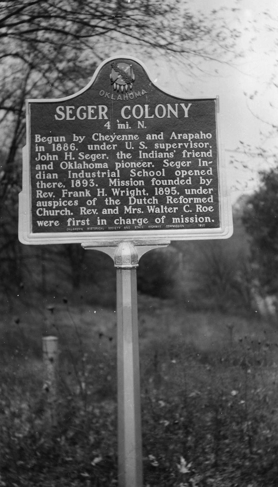
Seger Colony
Washita CountyLocation: on OK-152, two miles east of OK-115 junction
Material: Aluminum
Topics: American Indians, Settlement Patterns, Religion/Philosophy, Education
Seger Colony was opened by the Cheyenne and Arapaho in 1886 under John H. Seger, a missionary widely known for his work among the Plains Indians in western Oklahoma. A school opened in 1893. Some of their original buildings can be seen in the community of Colony.
Site of first Washita County Court House
Washita CountyLocation: southeast of OK-54 and OK-152 junction
Material: Granite
Topics: American Indians, Government, Territorial Period 1861–1907
Cloud Chief, originally Tacola, served as the first county seat. The area was settled by land run on April 19, 1892. On August 7, 1900, citizens voted to move the county seat to Cordell, but the US Supreme Court voided the election since the US Congress had designated Cloud Chief the county seat. In 1906, Congress officially named Cordell the county seat.
Tacola/Cloud Chief School
Washita CountyLocation: on county courthouse grounds in Cordell
Material: Granite
Topics: Education
Created in 1892, Tacola School met in a dugout until 1894 when a 30' x 50' building was built 1/2 mile southwest of this marker. In 1918, the school moved to a new building north of this marker. During the 1921 consolidation of school districts, the name changed to Cloud Chief. The high school moved to Cordell in 1958 and the school closed in 1960.
Search for Markers
Search by keyword or browse by county to learn about more than 600 historical markers created to recognize key locations, events, and people in Oklahoma history.
Please note that some markers listed in this database may have been moved, damaged, or are no longer standing.
Browse by County
Alfalfa County
Atoka County
Beaver County
Beckham County
Blaine County
Bryan County
Caddo County
Canadian County
Carter County
Cherokee County
Choctaw County
Cimarron County
Cleveland County
Comanche County
Cotton County
Craig County
Creek County
Custer County
Delaware County
Dewey County
Ellis County
Garfield County
Garvin County
Grady County
Grant County
Greer County
Harmon County
Harper County
Haskell County
Hughes County
Jackson County
Jefferson County
Johnston County
Kay County
Kingfisher County
Kiowa County
Le Flore County
Lincoln County
Logan County
Love County
Marshall County
Mayes County
McClain County
McCurtain County
McIntosh County
Murray County
Muskogee County
Noble County
Okfuskee County
Oklahoma County
Okmulgee County
Osage County
Ottawa County
Pawnee County
Payne County
Pittsburg County
Pontotoc County
Pottawatomie County
Pushmataha County
Roger Mills County
Rogers County
Seminole County
Sequoyah County
Stephens County
Texas County
Tillman County
Tulsa County
Wagoner County
Washington County
Washita County
Woods County
Woodward County
To find out more about the Oklahoma Historical Society Historical Marker Program or how to submit an application, please visit the Historical Marker Program page.
Missing or Damaged Markers
Please use our online form to report missing or damaged historical markers.
Report Missing or Damaged Markers
Contact Us
If you have questions, please contact:
Matthew Pearce
Oklahoma Historical Society
800 Nazih Zuhdi Drive
Oklahoma City, OK 73105
405-522-8659
matthew.pearce@history.ok.gov