
Historical Marker Program
Search Results
Your search returned 5 results.
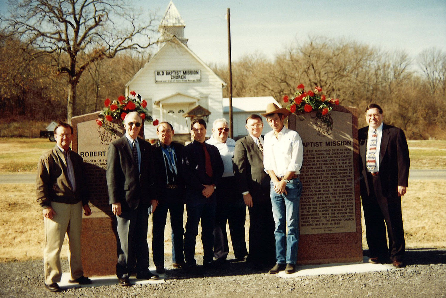
Baptist Mission
Adair CountyLocation: 3 miles north of junction of US 62 and US 59 at Old Baptist Mission Church, Westville vicinity
Coordinates: 36.035258, -94.583987
Material: Aluminum
Topics: American Indians; Education; Religion/Philosophy; Westward Expansion, 1803–1861
The present-day white frame building contains some of the original timbers of the log church built in 1839. Reverend James Bushyhead, the first supreme court judge of the Cherokee Nation, established the mission which the Cherokees called Bread Town. The Cherokee Messenger, a religious publication, was printed at the mission beginning in 1844. Bacone College at Muskogee is an outgrowth of the school begun at Baptist Mission.
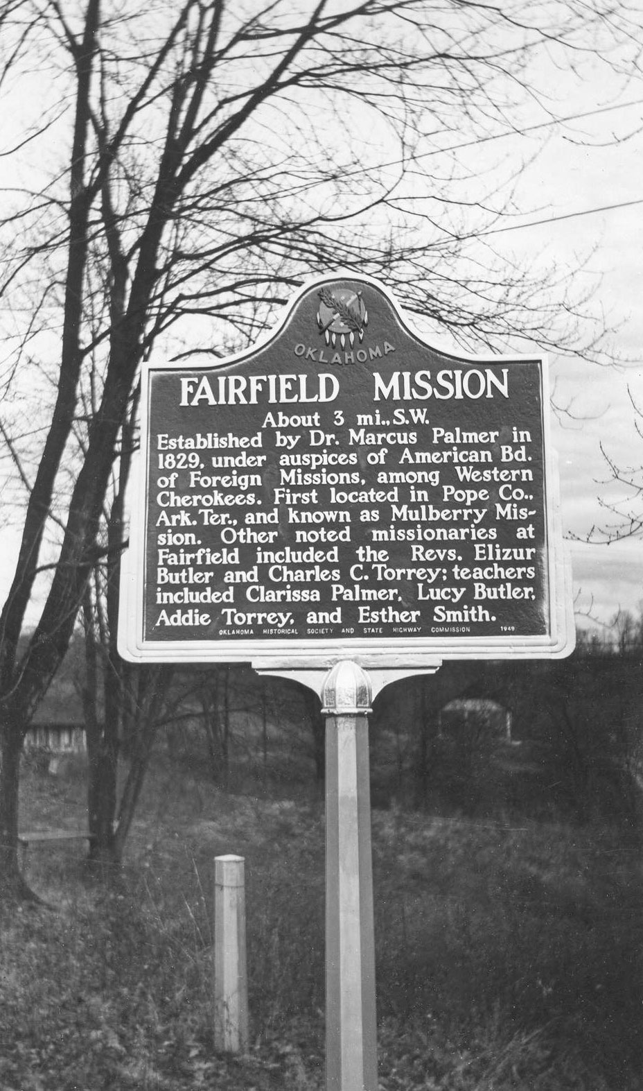
Fairfield Mission
Adair CountyLocation: at junction of OK-100 and US-59 on south edge of Stilwell
Topics: American Indians; Education; Religion/Philosophy; Westward Expansion, 1803–1861
The mission building, completed in 1829 by Dr. Marcus Palmer, a missionary to the Cherokees, stood in a grove of large trees a few hundred feet east of the cemetery now known as McLemore Cemetery. Noted missionaries and teachers at the mission included Elizur Butler, Charles C. Torrey, Clarissa Palmer, Lucy Butler, and Esther Smith. A circulation library, possibly the state's first, was established at the mission in 1832.
Note: This marker is missing.
Fort Wayne
Adair CountyLocation: on US-59 on south edge of Watts
Coordinates: 36.105500, -94.574600
Material: Granite
Sponsor(s): Oklahoma Historical Society
Topics: American Indians; Military; Westward Expansion, 1803–1861
Established in 1838 by Lt. Col. R. B. Mason, 1st Dragoons, US Army, at request of Arkansas citizens fearing Cherokees who were being removed from southeastern US. Named in honor of Gen. “Mad” Anthony Wayne, the fort was originally located in NE corner of present-day Watts on a hill, overlooking Illinois River. Considered poor location because many soldiers died there including Capt. John Stuart, 7th infantry. In 1839, fort was abandoned and moved to Beatie's Prairie west of Maysville, Arkansas. That site abandoned in 1842 and troops moved north to establish Fort Scott, Kansas.
Robert Rogers
Adair CountyLocation: three miles north of the junction of US-59 and OK-62
Topics: American Indians; Settlement Patterns; Westward Expansion, 1803–1861
Robert Rogers, father of Clem Vann Rogers and grandfather of Will Rogers, was born in Georgia on July 16, 1815. He and his wife, Sally Vann, moved to Indian Territory before the removal of the Five Tribes from the southeastern United States. Robert Rogers was a signer of the removal Treaty of New Echota. He died on July 4, 1842.
Note: Although the marker indicates that Robert Rogers signed the Treaty of New Echota, this claim has been disputed, and additional research is underway to assess its accuracy.
Starr Springs
Adair CountyLocation: at junction of OK-100 and US-59 on south edge of Stilwell
Topics: American Indians; Environmental/Cultural Ecology; Settlement Patterns; Westward Expansion, 1803–1861
Starr Springs was the head of Sallisaw Creek, a source of water for Stilwell since 1910. The area was the site of the 1853 murder of Andrew Adair and his son, George W. Adair, because of their support for Cherokee removal. The spring was named for George Harlan Starr, a prominent Cherokee, who purchased the site in 1867. The marker is a tribute to D. M. “Mack” Starr, respected and knowledgeable Cherokee historian, who died in 1995.
Note: This marker is missing.
(Page 1 of 1)
Search for Markers
Search by marker name or browse by county or subject to learn about more than 700 historical markers recognizing key locations, events, and people in Oklahoma history.
This database contains markers sponsored by the Oklahoma Historical Society and markers created by other organizations. Please note that some markers listed may have been relocated, damaged, or no longer exist.
Browse by County
Alfalfa County
Atoka County
Beaver County
Beckham County
Blaine County
Bryan County
Caddo County
Canadian County
Carter County
Cherokee County
Choctaw County
Cimarron County
Cleveland County
Comanche County
Cotton County
Craig County
Creek County
Custer County
Delaware County
Dewey County
Ellis County
Garfield County
Garvin County
Grady County
Grant County
Greer County
Harmon County
Harper County
Haskell County
Hughes County
Jackson County
Jefferson County
Johnston County
Kay County
Kingfisher County
Kiowa County
Latimer County
Lincoln County
Logan County
Love County
Major County
Marshall County
Mayes County
McClain County
McCurtain County
McIntosh County
Murray County
Muskogee County
Noble County
Okfuskee County
Oklahoma County
Okmulgee County
Osage County
Ottawa County
Pawnee County
Payne County
Pittsburg County
Pontotoc County
Pottawatomie County
Pushmataha County
Roger Mills County
Rogers County
Seminole County
Sequoyah County
Stephens County
Texas County
Tillman County
Tulsa County
Wagoner County
Washington County
Washita County
Woods County
Woodward County
To find out more about the Oklahoma Historical Society Historical Marker Program or how to submit an application, please visit the Historical Marker Program page.
Missing or Damaged Markers
Please use our online form to report missing or damaged historical markers.
Report Missing or Damaged Markers
Contact Us
If you have questions, please contact:
Matthew Pearce
Oklahoma Historical Society
800 Nazih Zuhdi Drive
Oklahoma City, OK 73105
405-522-8659
matthew.pearce@history.ok.gov