
Historical Marker Program
Search Results
Your search returned 6 results.
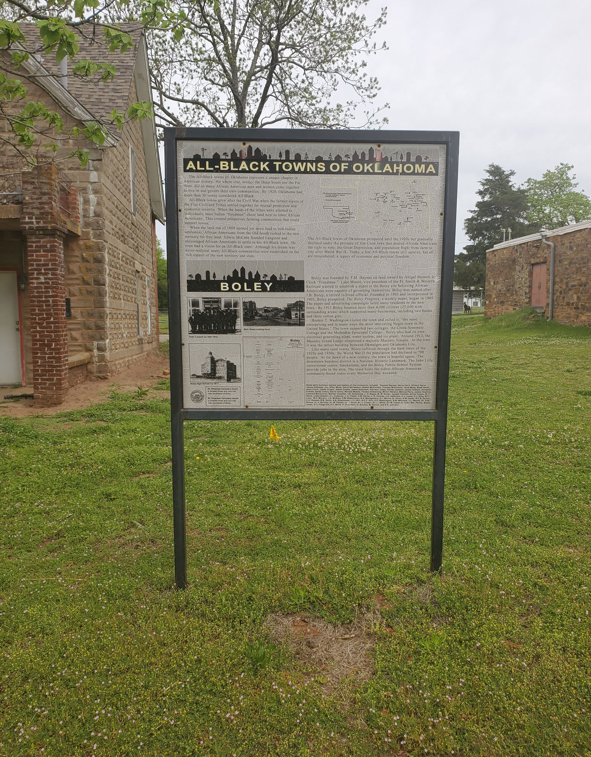
Boley
Okfuskee CountyLocation: in community of Boley
Coordinates: 35.493390, -96.484182
Material: Other (Interpretive panel)
Sponsor(s): Oklahoma Historical Society
Topics: American Indians; Ethnic Diversity; Government; Territorial Period, 1861–1907; Transportation; Urban Development
Boley is one of thirteen All-Black towns, out of more than fifty that once existed, remaining in Oklahoma. While Tullahassee is reportedly the oldest, most were established between 1889 and 1907 as African Americans sought security and control of their own destiny in a segregated world. Boley was established in 1903 on land owned by a Creek Freedwoman, Abigail Barnett. Boley was incorporated on May 11, 1905. By 1911 it boasted more than 4,000 citizens (25,000 in surrounding areas) and many businesses, including two banks and three cotton gins. The town hosts the oldest African American community-based rodeo every Memorial Day weekend.
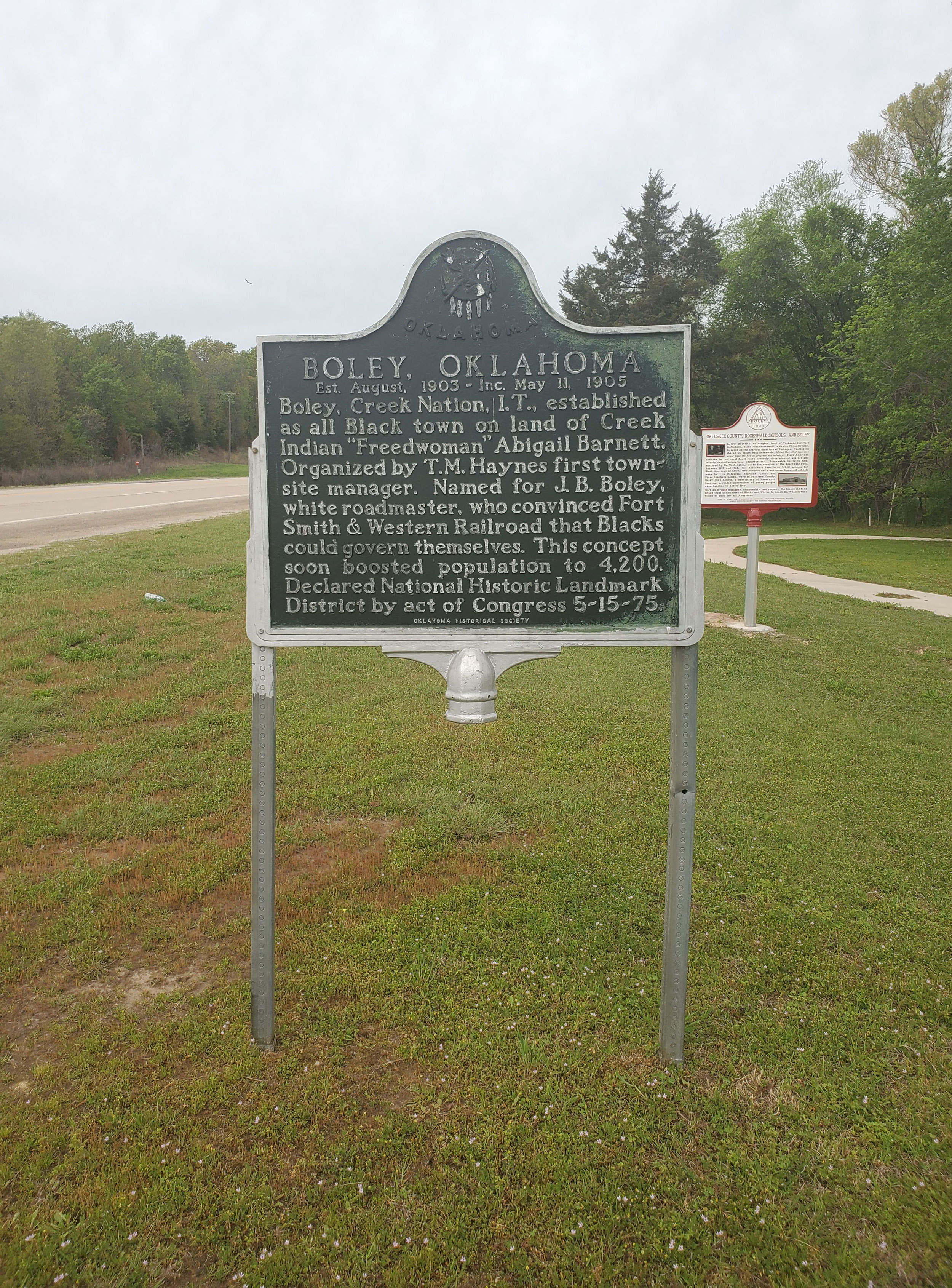
Boley, Oklahoma
Okfuskee CountyLocation: on US-62 in Boley
Coordinates: 35.488219, -96.484095
Material: Aluminum
Sponsor(s): Oklahoma Historical Society/Town of Boley
Topics: American Indians; Ethnic Diversity; Government; Territorial Period, 1861–1907; Transportation; Urban Development
Boley, Creek Nation, Indian Territory, established as an all Black town on land of Creek Indian Freedwoman Abigail Barnett. Organized by T.M. Haynes first townsite manager. Established August 1903. Incorporated May 11, 1905. Declared National Historic Landmark May 15, 1975.
Clearview
Okfuskee CountyLocation: on ground of Clearview School in Clearview
Coordinates: 35.398074, -96.190880
Material: Other (Interpretive panel)
Sponsor(s): Oklahoma Historical Society
Topics: Ethnic Diversity; Government; Mass Communication; Territorial Period, 1861–1907; Urban Development
Clearview is one of thirteen All-Black towns, out of more than fifty that once existed, remaining in Oklahoma. While Tullahassee is reportedly the oldest, most were established between 1889 and 1907 as African Americans sought security and control of their own destiny in a segregated world. Clearview was founded in 1903 along the tracks of the Fort Smith and Western Railroad. J. A. Roper, Lemuel Jackson, and John Grayson platted the townsite and formed the Lincoln Townsite Company to attract settlers and advertise settlement.
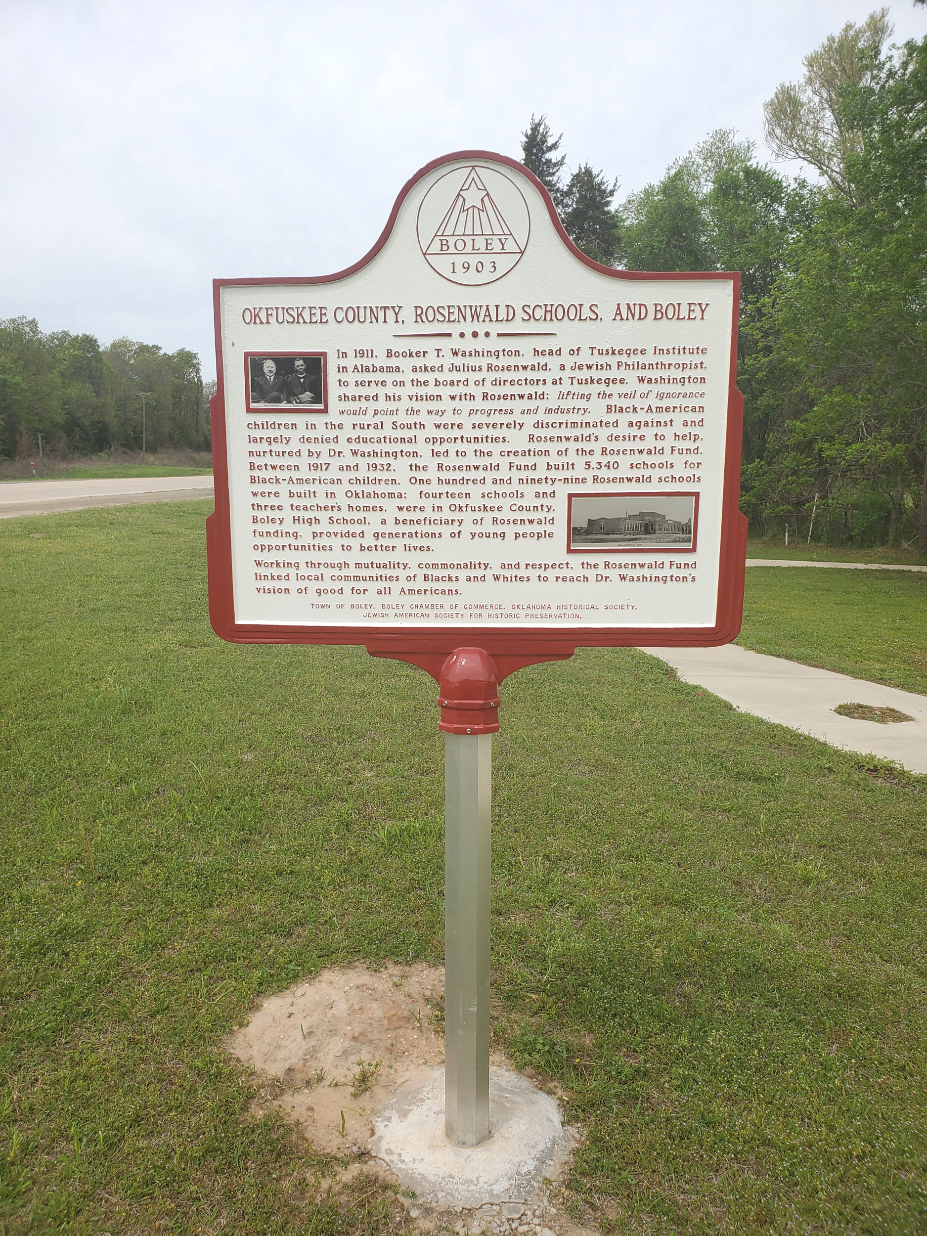
Okfuskee County, Rosenwald Schools, and Boley
Okfuskee CountyLocation: on US-62 in Boley
Coordinates: 35.488227, -96.484178
Material: Aluminum
Sponsor(s): Jewish American Society for Historic Preservation/Town of Boley
Topics: Early Statehood, 1907–1941; Education; Ethnic Diversity; Religion/Philosophy
In 1911, Booker T. Washington, head of Tuskegee Institute in Alabama, asked Julius Rosenwald, a Jewish Philanthropist, to serve on the board of directors at Tuskegee. Rosenwald's desire to help, nurtured by Dr. Washington, led to the creation of the Rosenwald Fund. Between 1917 and 1932, the Rosenwald Fund built 5,340 schools for Black-American children. One hundred and ninety-nine Rosenwald schools were built in Oklahoma: fourteen schools and three teacher's homes were in Okfuskee County. Boley High School, a beneficiary of Rosenwald funding, provided generations of young people opportunities to better lives.
Paden
Okfuskee CountyLocation: on Main Street in Paden
Coordinates: 35.506979, -96.567939
Material: Granite
Sponsor(s): Paden Community Council/Paden High School Student Council
Topics: Government; Territorial Period, 1861–1907; Urban Development
In 1903, the town was founded by and named for deputy US Marshal Paden Tolbert who served the federal court in the Western District of Arkansas presided over by Judge Isaac C. Parker, the "hanging judge."
Woody Guthrie
Okfuskee CountyLocation: on West Broadway Street in Okemah
Coordinates: 35.431312, -96.304030
Material: Other (Brick with bronze plaque)
Sponsor(s): Friends of Libraries U.S.A./Grammy Museum
Topics: Arts; Early Statehood, 1907–1941; Folklore/Folklife; Industrial Period, 1941–1982; Social/Culture
There are two historical markers commemorating the birthplace and hometown of Woody Guthrie at this site. Woody Guthrie was born in Okemah on July 14, 1912. A renowned folk singer and writer, Guthrie penned This Land is Your Land and numerous other songs, poems, and books. Guthrie's music inspired subsequent generations of musicians of every genre. There is another marker on site dedicating the park in memory of Dale Wolfe and Lawrence Powers.
(Page 1 of 1)
Search for Markers
Search by marker name or browse by county or subject to learn about more than 700 historical markers recognizing key locations, events, and people in Oklahoma history.
This database contains markers sponsored by the Oklahoma Historical Society and markers created by other organizations. Please note that some markers listed may have been relocated, damaged, or no longer exist.
Browse by County
Alfalfa County
Atoka County
Beaver County
Beckham County
Blaine County
Bryan County
Caddo County
Canadian County
Carter County
Cherokee County
Choctaw County
Cimarron County
Cleveland County
Comanche County
Cotton County
Craig County
Creek County
Custer County
Delaware County
Dewey County
Ellis County
Garfield County
Garvin County
Grady County
Grant County
Greer County
Harmon County
Harper County
Haskell County
Hughes County
Jackson County
Jefferson County
Johnston County
Kay County
Kingfisher County
Kiowa County
Latimer County
Lincoln County
Logan County
Love County
Major County
Marshall County
Mayes County
McClain County
McCurtain County
McIntosh County
Murray County
Muskogee County
Noble County
Okfuskee County
Oklahoma County
Okmulgee County
Osage County
Ottawa County
Pawnee County
Payne County
Pittsburg County
Pontotoc County
Pottawatomie County
Pushmataha County
Roger Mills County
Rogers County
Seminole County
Sequoyah County
Stephens County
Texas County
Tillman County
Tulsa County
Wagoner County
Washington County
Washita County
Woods County
Woodward County
To find out more about the Oklahoma Historical Society Historical Marker Program or how to submit an application, please visit the Historical Marker Program page.
Missing or Damaged Markers
Please use our online form to report missing or damaged historical markers.
Report Missing or Damaged Markers
Contact Us
If you have questions, please contact:
Matthew Pearce
Oklahoma Historical Society
800 Nazih Zuhdi Drive
Oklahoma City, OK 73105
405-522-8659
matthew.pearce@history.ok.gov