
Historical Marker Program
Search Results
Your search returned 8 results.
Elias Boudinot
Cherokee CountyLocation: at Worcester Cemetery at Park Hill
Material: Granite
Topics: American Indians; Government; Mass Communication; Westward Expansion, 1803–1861
Kulakenna "Buck" Watie, brother of Stand Watie, took the name of his benefactor, Elias Boudinot of New Jersey. After completing his education, Boudinot signed the Treaty of New Echota (Georgia) in 1835 that provided for the removal of the Cherokees to Indian Territory. He was clerk of the Cherokee National Council and editor of the Cherokee Phoenix before removal. After he came west, Boudinot was assassinated on June 22, 1839, near the Park Hill Mission Press where he was assisting the famous missionary Reverend Samuel Worcester.
First Baptist Convention in Indian Territory
Cherokee CountyLocation: at corner of College and Downing Streets in Tahlequah. OHBC
Topics: Education; Ethnic Diversity; Religion/Philosophy
American Indian, African American, and white Baptists convened here in June 1883 to form the Missionary and Educational Convention, Oklahoma's first Baptist Convention.
Indian Base Line
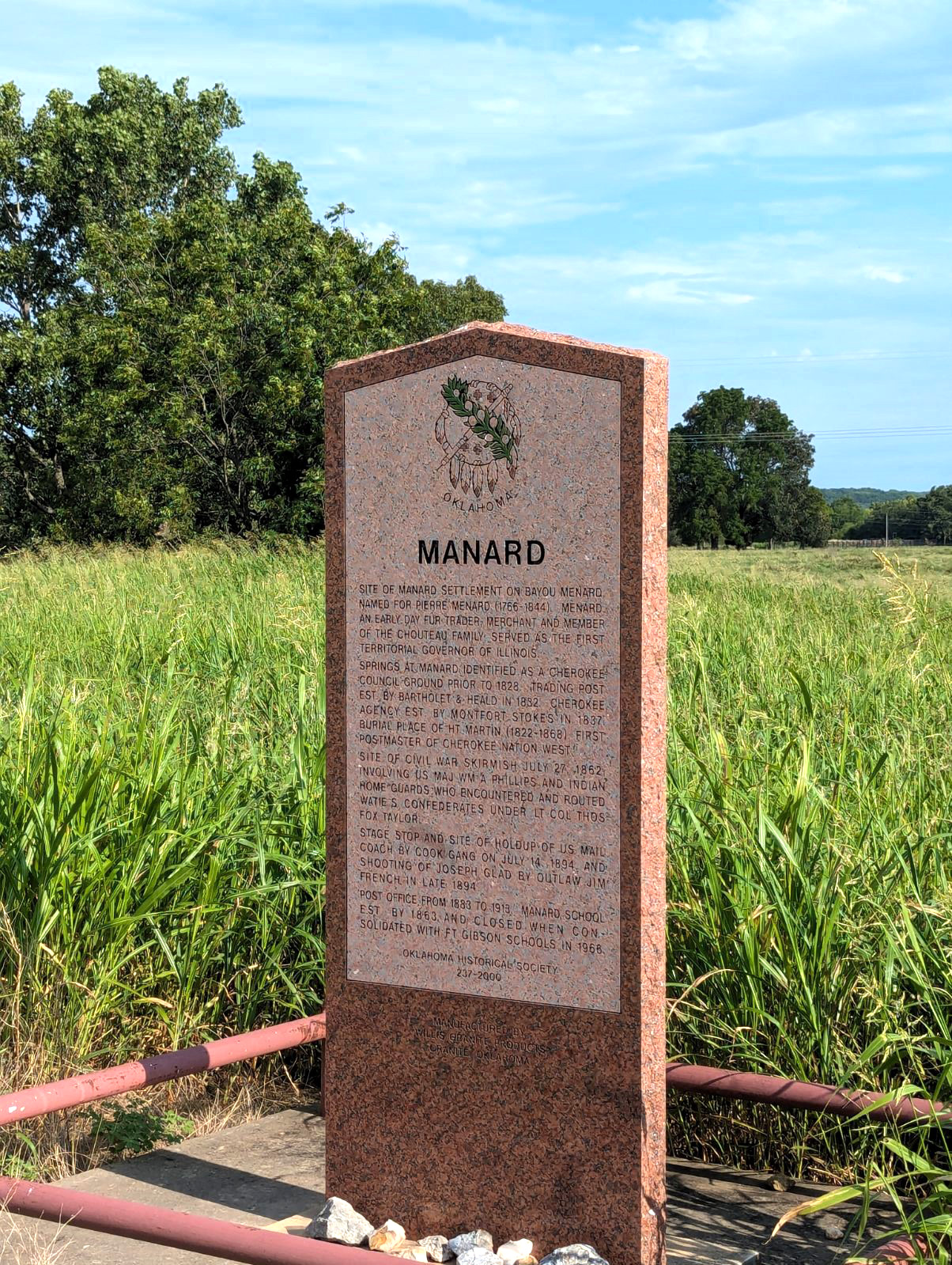
Cherokee CountyManard
Cherokee CountyLocation: on OK-82 south of Tahlequah, one mile east of the Cherokee-Muskogee County line
Coordinates: 35.799587, -95.104504
Material: Granite
Sponsor(s): Jennifer Sparks and the Oklahoma Historical Society
Topics: American Indians; Indian and Frontier Trade; Law and Order; Military; Territorial Period, 1861–1907
Named for early-day fur trader Pierre Manard, a member of the Chouteau family, the springs were identified as a Cherokee council ground prior to 1828. A trading post and agency were established in 1828 and 1837, respectively. Manard was the site of a Civil War skirmish on July 27, 1862, in which Federal troops and the Indian Home Guard routed Confederate forces. The Manard stage stop was the site of a hold up of the US Mail coach by the Cook gange on July 14, 1894, and the shooting of Joseph Glad by outlaw Jim French in late 1894. The Manard post office operated from 1883 to 1913. Manard School was established by 1863 and closed when consolidated with Fort Gibson schools in 1968.
Park Hill
Cherokee CountyLocation: 1/2 mile east of junction of US-62 and OK-82 on south edge of Tahlequah.
Topics: American Indians; Family/Household; Social/Cultural
Before the Civil War, Park Hill was the center of culture and learning in the Cherokee Nation. See Park Hill Press.
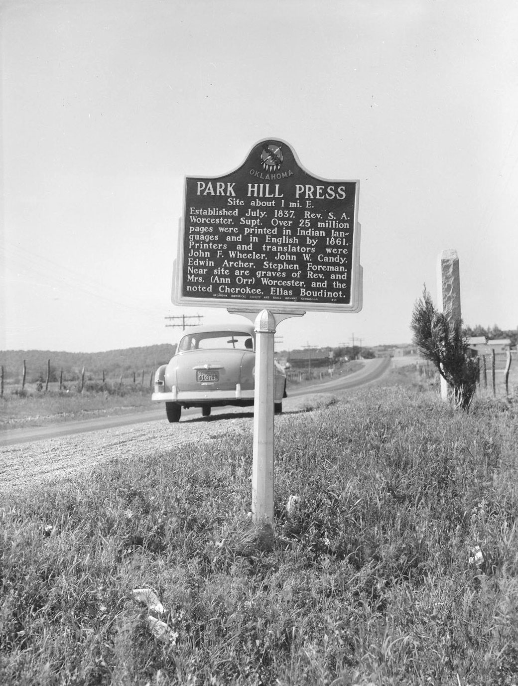
Park Hill Press
Cherokee CountyLocation: 1/2 mile east of junction of US-62 and OK-82 on south edge of Tahlequah.
Material: Aluminum
Topics: American Indians; Mass Communication; Religion/Philosophy
In 1837, Reverend Samuel Worcester moved his printing plant from Union Mission to Park Hill. Over the next quarter-century, more than 25 million pages were printed in English and American Indian languages.
Riley’s Chapel
Cherokee CountyLocation: 1/2 mile east of junction of US-62 and OK-82 on south edge of Tahlequah.
Material: Aluminum
Topics: American Indians; Religion/Philosophy; Westward Expansion, 1803–1861
In 1843, Reverend Thomas Bertholf built Riley's Chapel on a hill south of the Cherokee capital. The first annual Indian Mission Conference of the Methodist Church was held at the chapel on October 23, 1844. The building was razed in 1868.
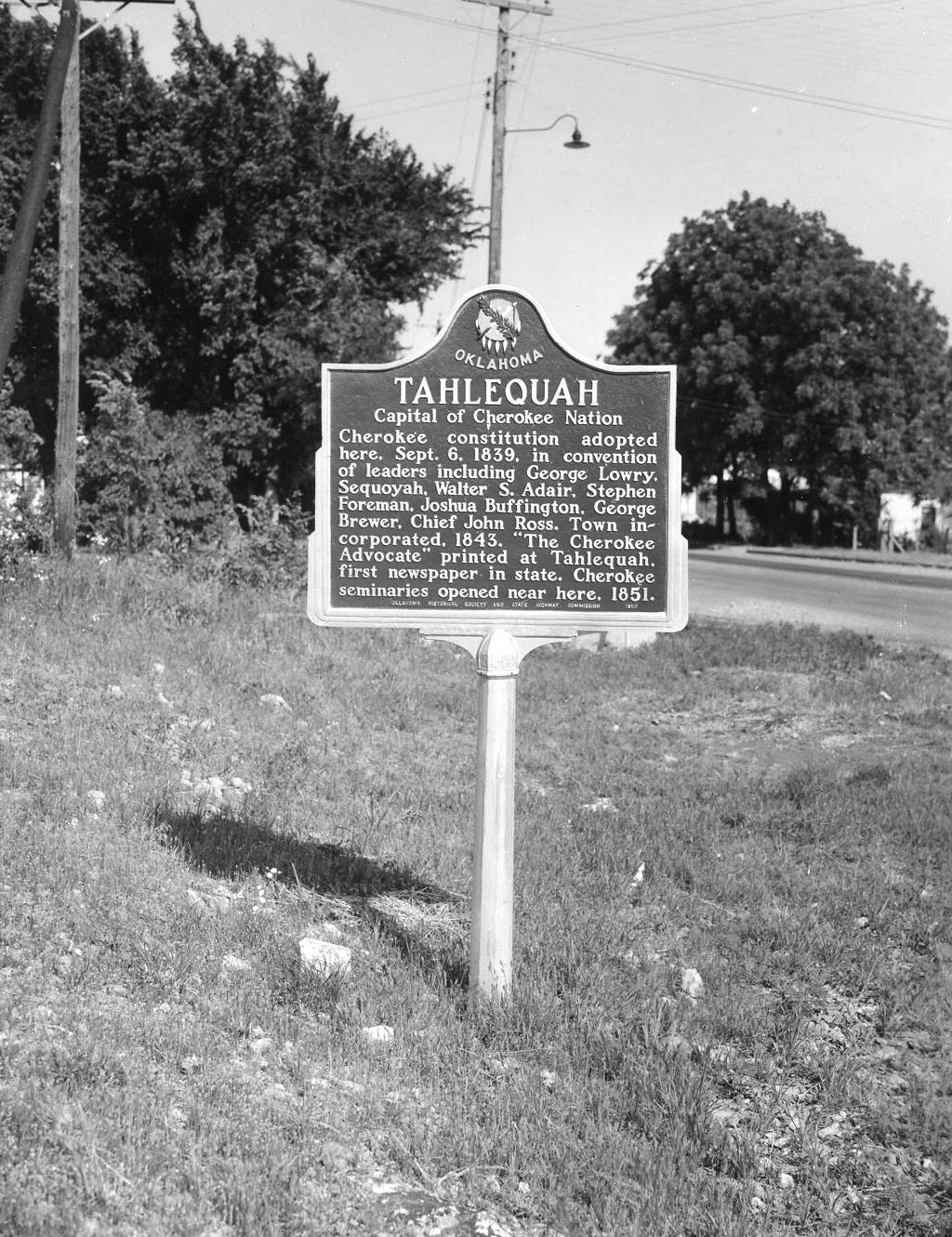
Tahlequah
Cherokee CountyLocation: on OK-51 between Lee and Morris Streets in Tahlequah
Material: Aluminum
Topics: American Indians; Government; Mass Communication
Tahlequah was the capital of the Cherokee Nation until statehood and the closing of the Cherokee government. Oklahoma's first newspaper, the Cherokee Advocate, was printed here. The last Cherokee capitol, constructed on the city square in 1872, became the Cherokee County courthouse at statehood.
(Page 1 of 1)
Search for Markers
Search by marker name or browse by county or subject to learn about more than 700 historical markers recognizing key locations, events, and people in Oklahoma history.
This database contains markers sponsored by the Oklahoma Historical Society and markers created by other organizations. Please note that some markers listed may have been relocated, damaged, or no longer exist.
Browse by County
Alfalfa County
Atoka County
Beaver County
Beckham County
Blaine County
Bryan County
Caddo County
Canadian County
Carter County
Cherokee County
Choctaw County
Cimarron County
Cleveland County
Comanche County
Cotton County
Craig County
Creek County
Custer County
Delaware County
Dewey County
Ellis County
Garfield County
Garvin County
Grady County
Grant County
Greer County
Harmon County
Harper County
Haskell County
Hughes County
Jackson County
Jefferson County
Johnston County
Kay County
Kingfisher County
Kiowa County
Latimer County
Lincoln County
Logan County
Love County
Major County
Marshall County
Mayes County
McClain County
McCurtain County
McIntosh County
Murray County
Muskogee County
Noble County
Okfuskee County
Oklahoma County
Okmulgee County
Osage County
Ottawa County
Pawnee County
Payne County
Pittsburg County
Pontotoc County
Pottawatomie County
Pushmataha County
Roger Mills County
Rogers County
Seminole County
Sequoyah County
Stephens County
Texas County
Tillman County
Tulsa County
Wagoner County
Washington County
Washita County
Woods County
Woodward County
To find out more about the Oklahoma Historical Society Historical Marker Program or how to submit an application, please visit the Historical Marker Program page.
Missing or Damaged Markers
Please use our online form to report missing or damaged historical markers.
Report Missing or Damaged Markers
Contact Us
If you have questions, please contact:
Matthew Pearce
Oklahoma Historical Society
800 Nazih Zuhdi Drive
Oklahoma City, OK 73105
405-522-8659
matthew.pearce@history.ok.gov