
Historical Marker Program
Search Results
Your search returned 12 results.
Altus Air Force Base
Jackson CountyLocation: on Altus Air Force Base
Topics: Government; Industrial Period, 1841–1892; Military
Features of Altus Air Force Base include a display of American aircraft stationed at the air base and a memorial to R. W. "Dick" Moore who was instrumental in re-establishing Altus Air Force Base after World War II.
Altus Jackson County Well
Jackson CountyLocation: on the north side of the county courthouse in Altus
Topics: Environmental/Cultural Ecology; Territorial Period, 1861–1907; Urban Development; Water
This hand-dug brick-lined well was the community's only water supply from 1889 to the late 1920s. The well was paved over in 1937 but was rediscovered and restored in 1990.
City of Altus
Jackson CountyLocation: at Park Lane and East Broadway in Altus
Topics: Industrial Period, 1841–1892; Military
In 1955, this B-47, christened City of Altus, was the first bomber to land on the runway at Altus Air Force Base.
Doan’s Crossing
Jackson CountyLocation: on County Road East 1800, six miles west and six miles south of Tipton
Coordinates: Unknown
Material: Concrete with bronze plaque
Sponsor(s): Oklahoma Historical Society
Topics: Ranching; Territorial Period, 1861–1907; Transportation
The Texas Cattle Trail (Dodge City or Great Western Trail) crossed the Red River here where C. F. Doan operated a store. More than 19 million cattle crossed the river until the crossing was abandoned in 1895. Also see "The Great Western Cattle Trail (Altus)" and "Western Cattle Trail/Friendship".
Note: This marker is presumed damaged or no longer extant.
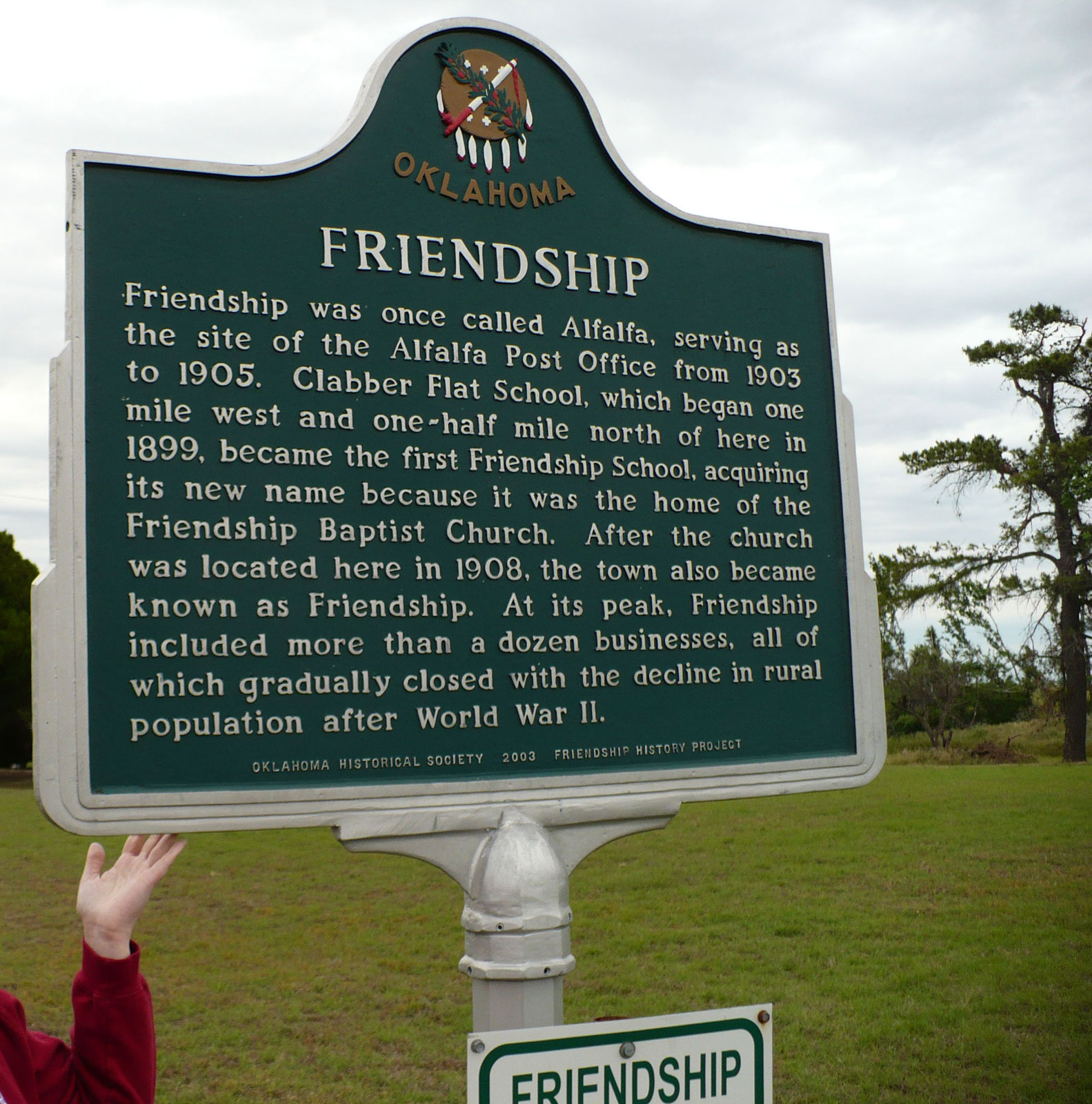
Friendship School
Jackson CountyLocation: on County Road East 159 at site of former school northeast of Altus.
Topics: Early Statehood, 1907–1941; Education; Industrial Period; Religion/Philosophy; Settlement Patterns
From 1937 to 1963, children from surrounding areas were educated in this country school. Initially called Clabber Flat School, the school acquired its new name because it was the home of Friendship Baptist Church. The town of Alfalfa also took the name.
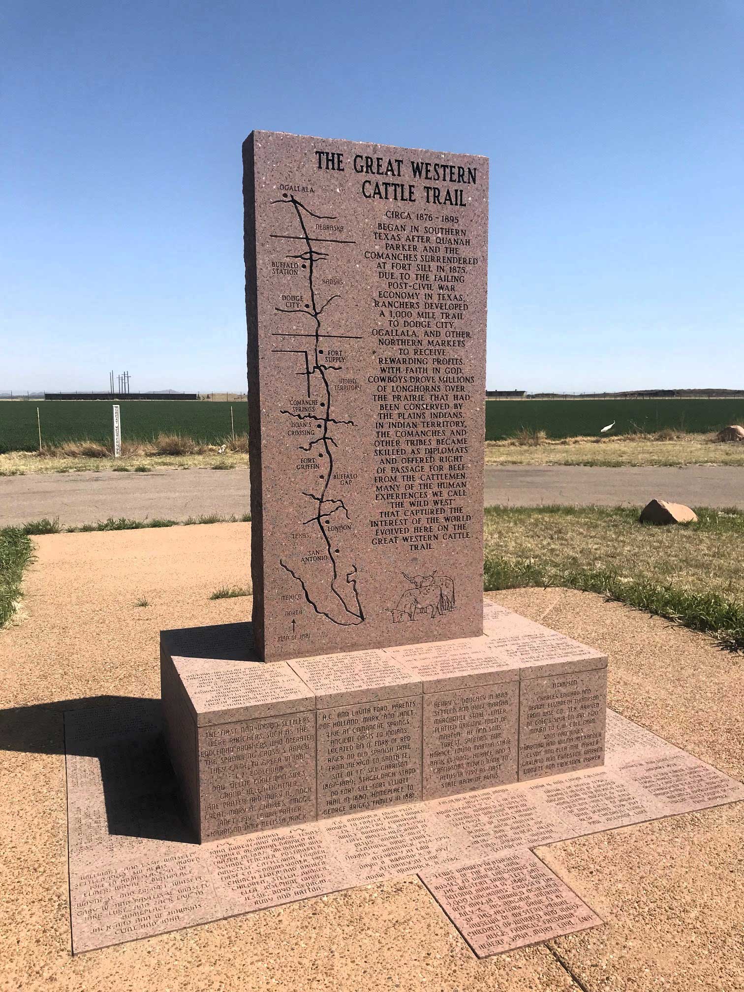
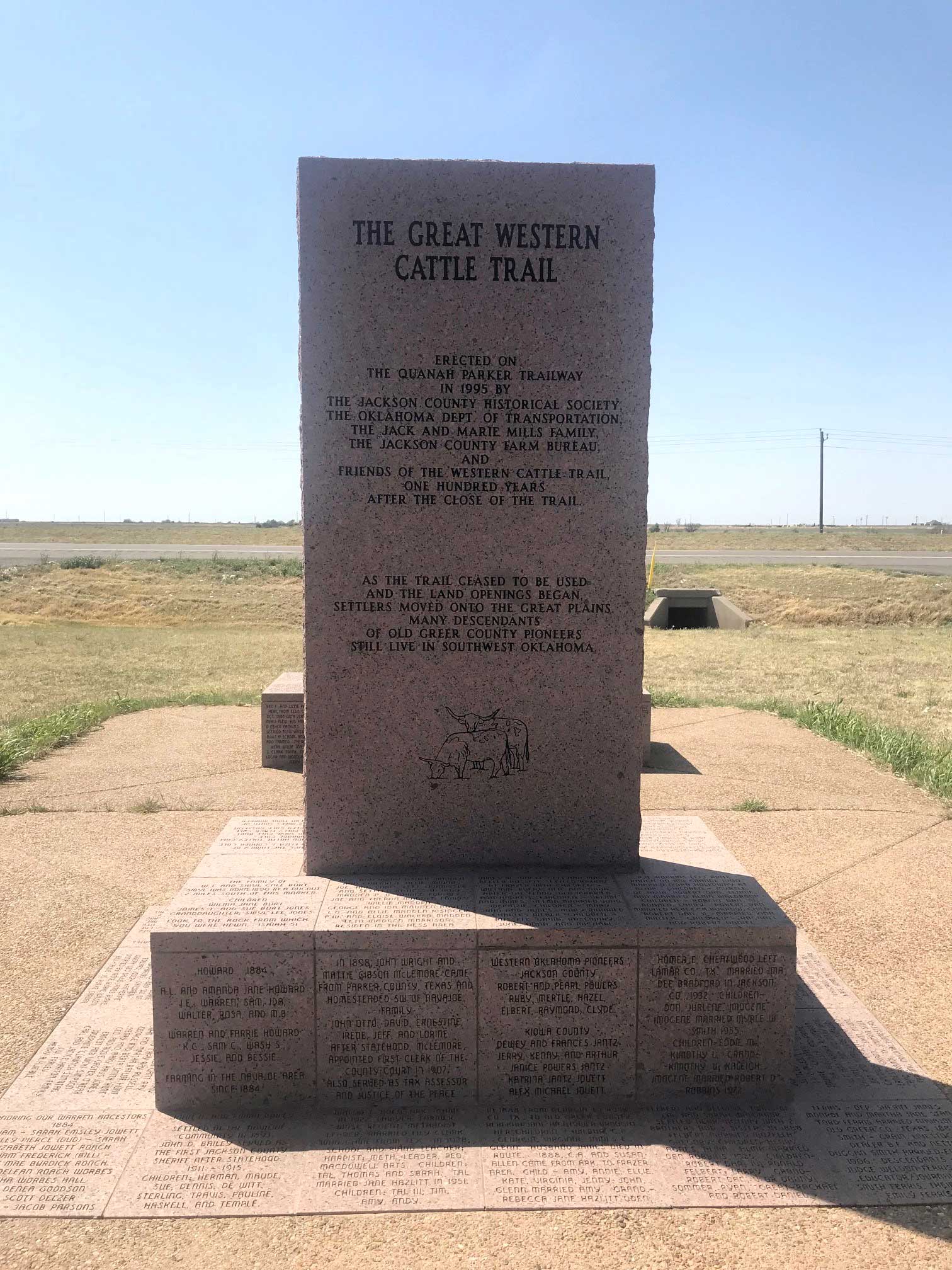
The Great Western Trail (Altus)
Jackson CountyLocation: on US-62, two miles east of Altus
Coordinates: 34.638035, -99.268591
Material: Granite
Sponsor(s): Jackson County Historical Society
Topics: Ranching; Territorial Period, 1861–1907; Transportation
Beginning in 1874, millions of cattle and horses were driven from Texas through what became western Oklahoma over the westernmost of the famous cattle trails. The trail crossed the Red River and Doan's Crossing in Jackson County and continued north to Dodge City, Kansas. By the 1880s, many drives continued past Dodge City into Nebraska, Wyoming, Montana, and Canada. The last recorded use of the trail occurred in 1894. A series of granite and concrete markers commemorate the trail route through Oklahoma.
Locomotive 1615
Jackson CountyLocation: at 601 Katy Drive in Altus
Topics: Industrial Period, 1841–1892; Mining; Social/Cultural; Transportation
The Russian czar Nicholas II, ordered this steam locomotive for use in World War I. When the Russian regime was overthrown, the Frisco Railroad purchased the locomotive. It was later used in lead and zinc mines in northeast Oklahoma.
Martha School
Jackson CountyLocation: at 15863 South County Road 201
The Martha School served the area's children beginning in 1896.
Museum of the Western Prairie
Jackson CountyLocation: at 110 North Hightower, Altus
Topics: Education; Social/Cultural; Territorial Period, 1861–1907
Illustrating the colorful past of the western portion of Oklahoma, this museum contains many interesting exhibits portraying the early homesteaders of the region.
Town of Navajoe
Jackson CountyMaterial: Granite
Waterbird Missile
Jackson CountyLocation: at 601 Katy Drive in Altus
Topics: Government; Military
A mock Atlas missile was used to test this underground silo's weight-and-balance systems at nearby Altus Air Force Base in the 1960s. It was called "waterbird," because it was filled with water, rather than the liquid oxygen in the actual missiles.
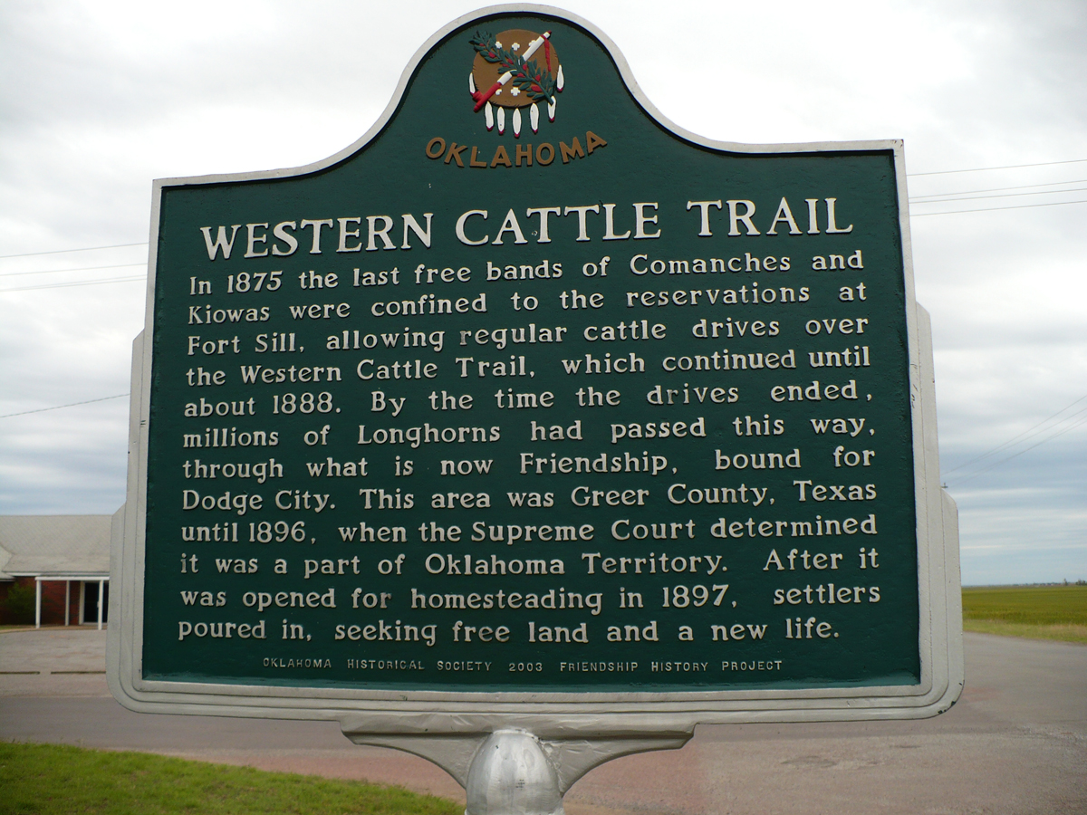
Western Cattle Trail/Friendship
Jackson CountyLocation: on County Road 210 in town of Friendship
Coordinates: 34.696110, -99.228960
Material: Aluminum
Sponsor(s): Friendship History Project
Topics: Ranching; Religion/Philosophy; Settlement Patterns; Territorial Period, 1861–1907; Transportation; Urban Development
In 1875 the last free bands of Comanches and Kiowas were confined to reservations at Fort Sill, allowing regular cattle drives over the Western Cattle Trail. By the time the drives ended, millions of longhorns passed this way, through what is now Friendship, bound for Dodge City. This area was Greer County, Texas, until 1896, when the US Supreme Court determined it was a part of Oklahoma Territory. Friendship was once called Alfalfa, serving as the site of the Alfalfa Post Office from 1903 to 1905. Clabber Flat School, which began one mile west and one-half mile north of here in 1899, became the first Friendship School, acquiring its new name because it was the home of the Friendship Baptist Church. After the church was located here in 1908, the town also became known as Friendship. At its peak, Friendship included more than a dozen businesses, all of which gradually closed with the decline in rural population after World War II.
(Page 1 of 1)
Search for Markers
Search by marker name or browse by county or subject to learn about more than 700 historical markers recognizing key locations, events, and people in Oklahoma history.
This database contains markers sponsored by the Oklahoma Historical Society and markers created by other organizations. Please note that some markers listed may have been relocated, damaged, or no longer exist.
Browse by County
Alfalfa County
Atoka County
Beaver County
Beckham County
Blaine County
Bryan County
Caddo County
Canadian County
Carter County
Cherokee County
Choctaw County
Cimarron County
Cleveland County
Comanche County
Cotton County
Craig County
Creek County
Custer County
Delaware County
Dewey County
Ellis County
Garfield County
Garvin County
Grady County
Grant County
Greer County
Harmon County
Harper County
Haskell County
Hughes County
Jackson County
Jefferson County
Johnston County
Kay County
Kingfisher County
Kiowa County
Latimer County
Lincoln County
Logan County
Love County
Major County
Marshall County
Mayes County
McClain County
McCurtain County
McIntosh County
Murray County
Muskogee County
Noble County
Okfuskee County
Oklahoma County
Okmulgee County
Osage County
Ottawa County
Pawnee County
Payne County
Pittsburg County
Pontotoc County
Pottawatomie County
Pushmataha County
Roger Mills County
Rogers County
Seminole County
Sequoyah County
Stephens County
Texas County
Tillman County
Tulsa County
Wagoner County
Washington County
Washita County
Woods County
Woodward County
To find out more about the Oklahoma Historical Society Historical Marker Program or how to submit an application, please visit the Historical Marker Program page.
Missing or Damaged Markers
Please use our online form to report missing or damaged historical markers.
Report Missing or Damaged Markers
Contact Us
If you have questions, please contact:
Matthew Pearce
Oklahoma Historical Society
800 Nazih Zuhdi Drive
Oklahoma City, OK 73105
405-522-8659
matthew.pearce@history.ok.gov