
Historical Marker Program
Search Results
Your search returned 44 results.
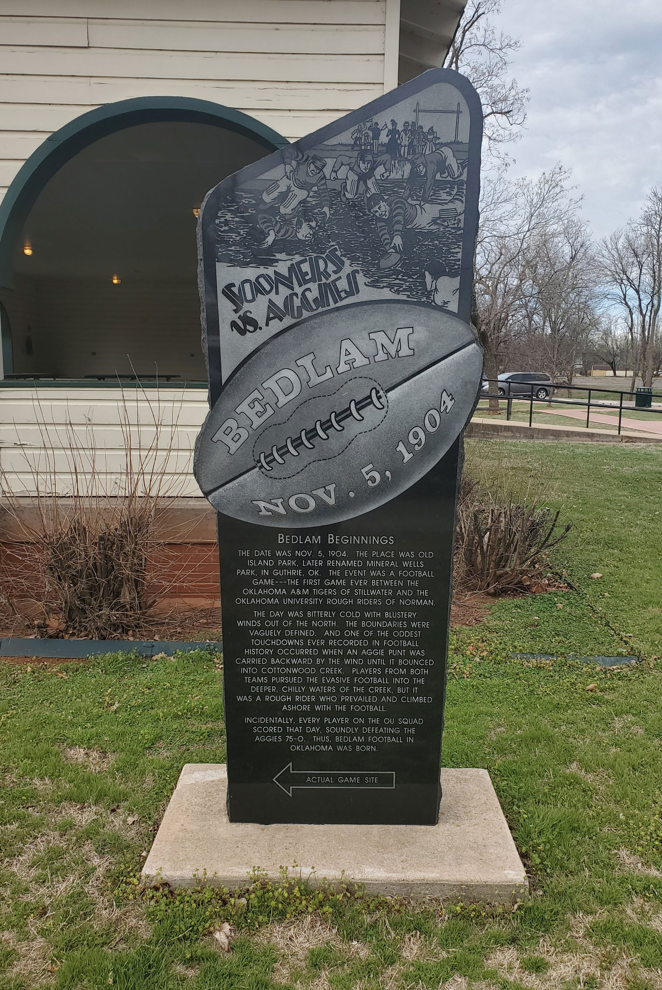
Bedlam
Logan CountyLocation: in Mineral Wells Park on south edge of Guthrie
Coordinates: 35.868773, -97.426550
Sponsored by: OU/OSU Bedlam Centennial
Material: Granite
Topics: Social/Cultural, Recreational/Service, Territorial Period 1861–1907
Commemorates the first football game between Oklahoma State University and the University of Oklahoma held in present-day Mineral Wells Park in Guthrie on November 5, 1904.
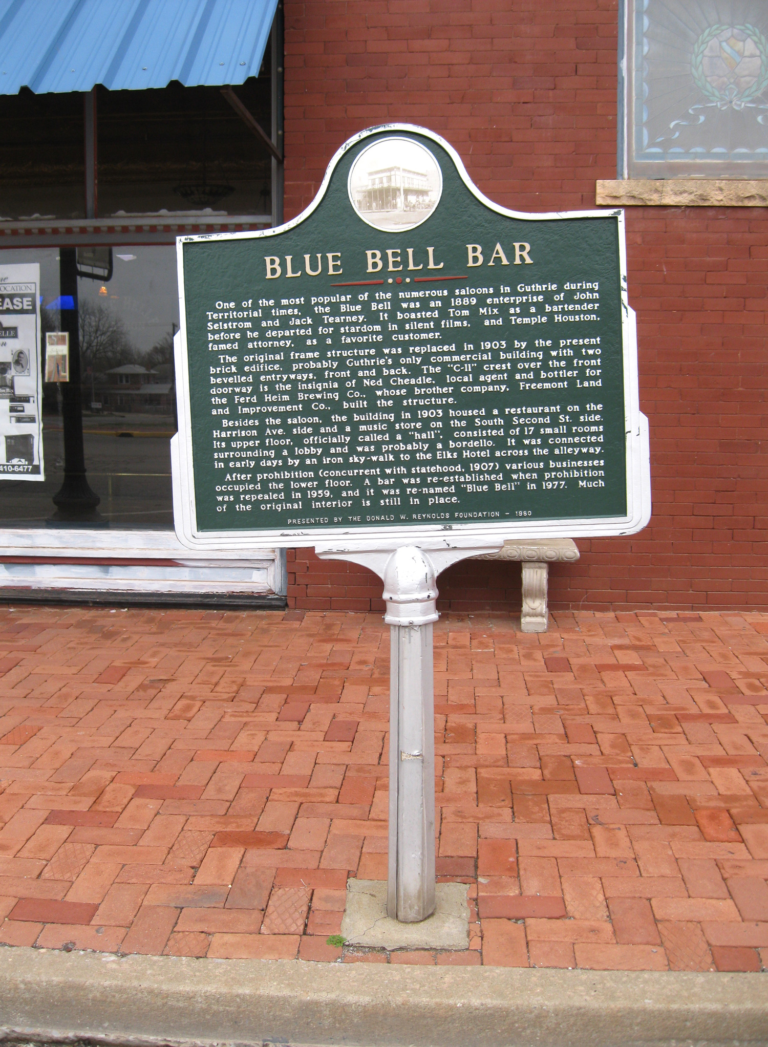
Blue Bell Bar
Logan CountyLocation: at Harrison Avenue and Second Street in Guthrie
Coordinates: 35.877057, -97.427351
Sponsored by: Donald W. Reynolds Foundation
Material: Aluminum
Topics: Recreational/Service, Social/Cultural, Folklife, Territorial Period 1861–1907
This was one of Guthrie's most popular saloons during territorial days. Cowboy star Tom Mix was a bartender at the Blue Bell before he left for Hollywood. The original frame building was replaced by the present brick structure in 1903.

Bonfils Building
Logan CountyLocation: at 107 South Second Street in Guthrie
Coordinates: 35.877679, -97.427689
Sponsored by: Donald W. Reynolds Foundation
Material: Aluminum
Topics: Industry/Business, Folklife, Mass Communication, Territorial Period 1861–1907
F. C. Bonfils ran his real estate business from an office in the first floor of this building and lived on the second floor. Bonfils, a descendant of Napoleon Bonaparte, was considered a con man in his early years. However, he later moved to Denver, Colorado, and co-founded the Denver Post newspaper.
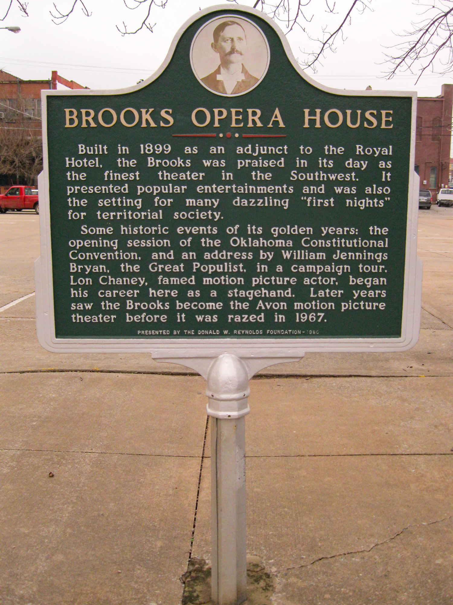
Brooks Opera House
Logan CountyLocation: at Harrison Avenue and Wentz Avenue in Guthrie
Coordinates: 35.877068, -97.424580
Sponsored by: Donald W. Reynolds Foundation
Material: Aluminum
Topics: Arts, Territorial Period 1861–1907, Social/Cultural, Early Statehood 1907–1941, Government
Constructed in 1899 by owner/manager James B. Brooks, this three-story limestone opera house seated 1,100 and contained ten finely appointed private boxes. It was furnished with folding upholstered chairs, steam heat, electric lights, hot and cold water, and other amenities. The adjacent Hotel Royal contained 80 guest rooms. On November 16, 1907, Governor Charles Haskell took the oath of office as the state of Oklahoma's first governor in room 47 of the hotel. Later that day, he was sworn in again in a public ceremony on the steps of the Carnegie Library.
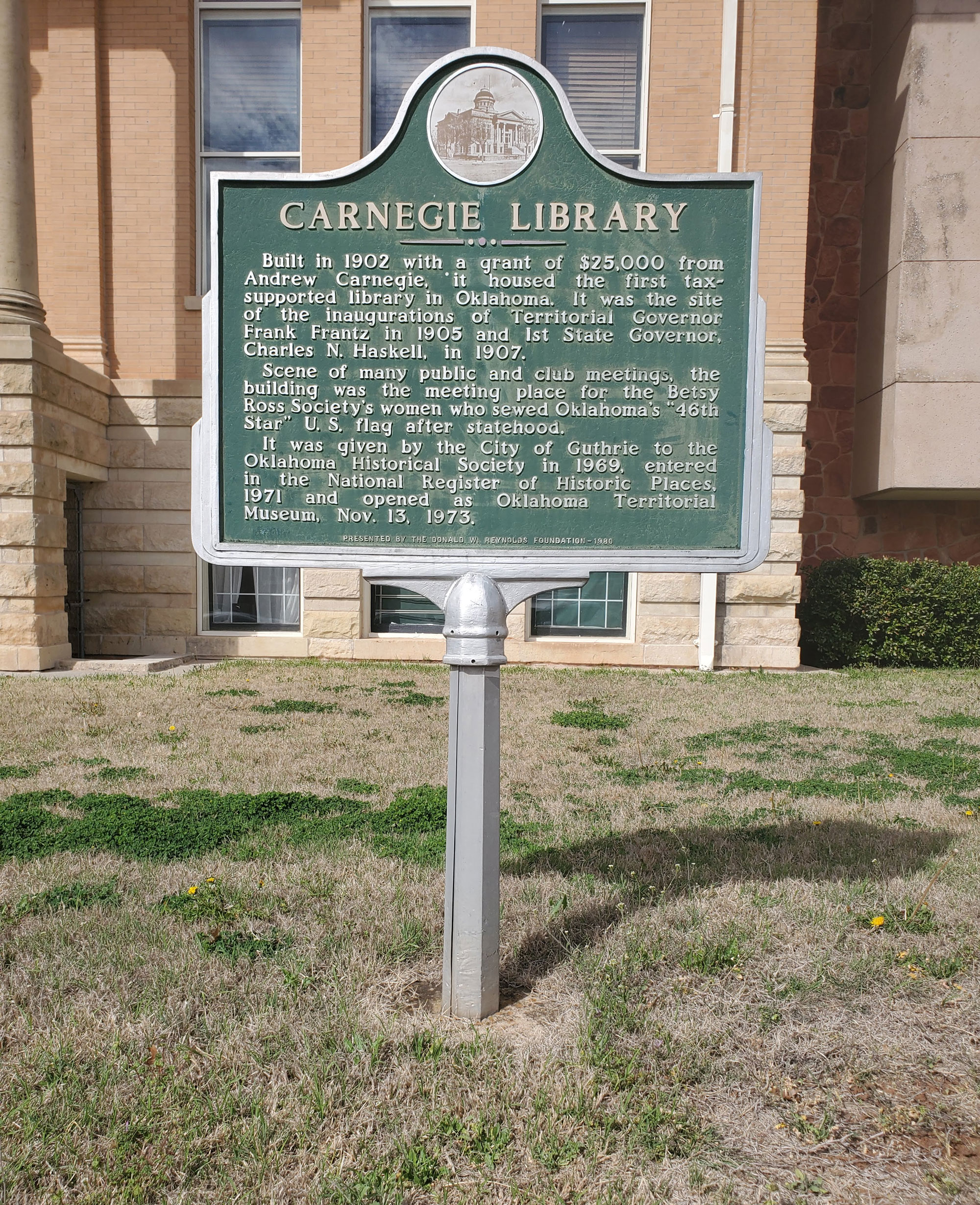
Carnegie Library
Logan CountyLocation: at 402 East Oklahoma Avenue in Guthrie
Coordinates: 35.878167, -97.421080
Sponsored by: Donald W. Reynolds Foundation
Material: Aluminum
Topics: Arts, Social/Cultural, Government, Territorial Period 1861–1907, Early Statehood 1907–1941
Constructed in 1902 with a $25,000 grant from Andrew Carnegie, this restored building is now connected to the Oklahoma Territorial Museum. The last territorial governor and the first state governor took their oaths of office here. The mock wedding symbolizing the joining of Oklahoma and Indian Territory as the state of Oklahoma took place on the library steps on November 16, 1907.
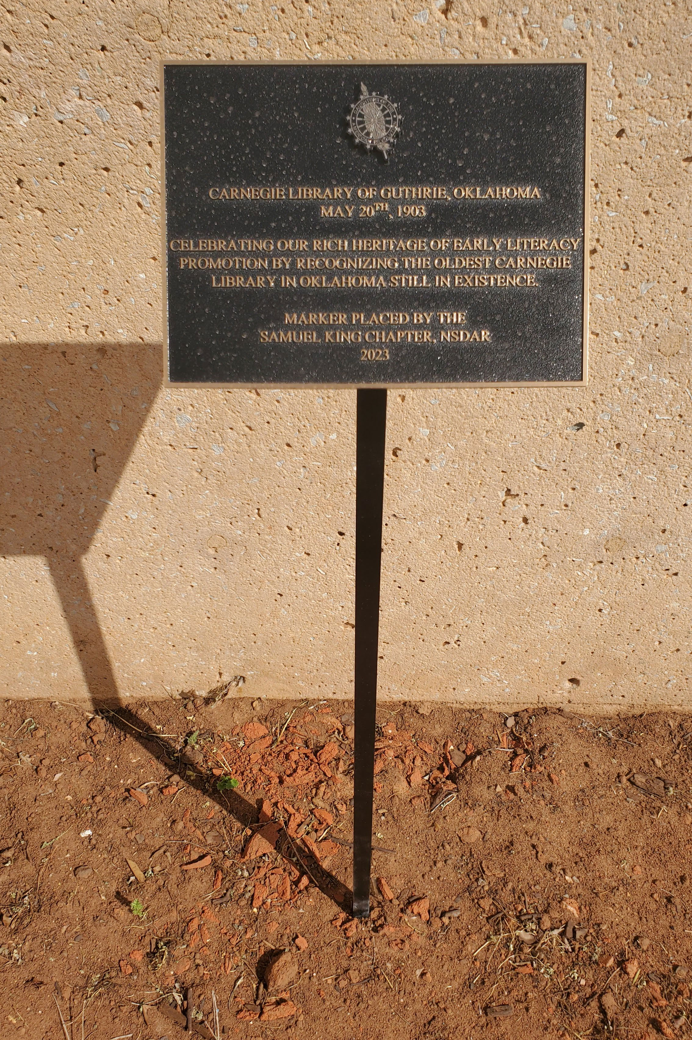
Carnegie Library
Logan CountyLocation: outside main entrance of Oklahoma Territorial Museum in Guthrie
Coordinates: 35.878187, -97.420805
Sponsored by: Daughters of the American Revolution
Material: Aluminum
Topics: Arts, Social/Cultural, Territorial Period 1861–1907
Celebrating our rich heritage of early literacy promotion by recognizing the oldest Carnegie Library in Oklahoma still in existence.
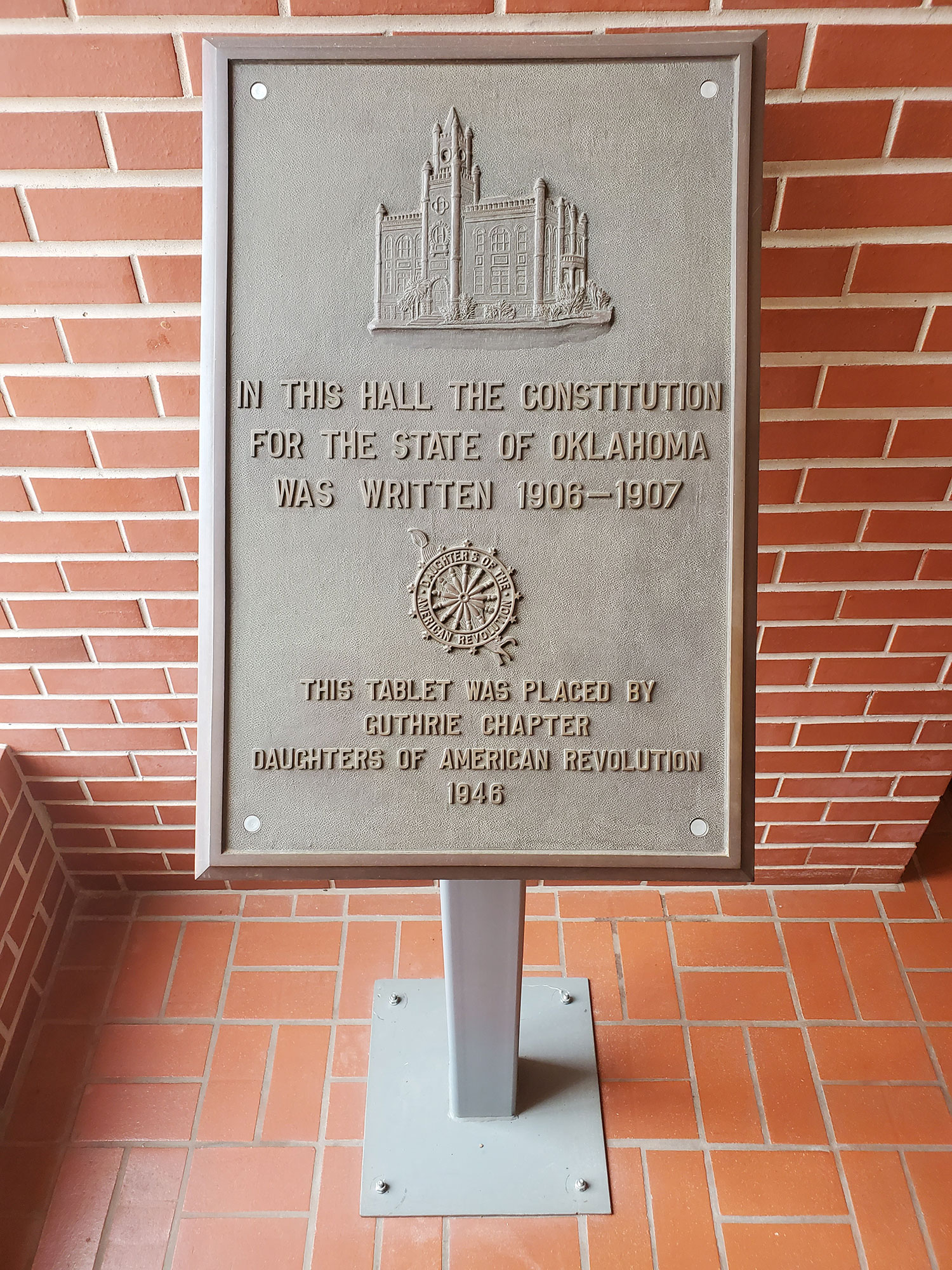
Constitutional Convention
Logan CountyLocation: inside City Hall, 101 North Second, Guthrie (DAR)
Coordinates: 35.878274, -97.427782
Sponsored by: Daughters of the American Revolution
Material: Bronze tablet
Topics: Government, Territorial Period 1861–1907, Early Statehood 1907–1941
Oklahoma's Constitutional Convention was held in 1906 and 1907 in the old City Hall at this site.
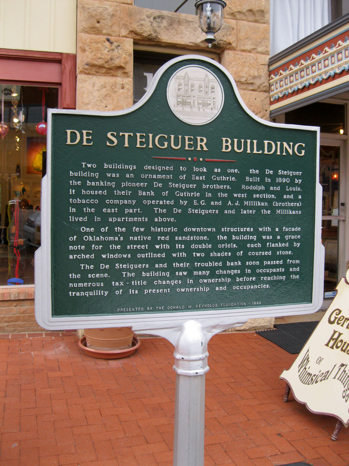
De Steiguer Building
Logan CountyLocation: at Division Street and Oklahoma Avenue in Guthrie
Coordinates: 35.878109, -97.424779
Sponsored by: Donald W. Reynolds Foundation
Material: Aluminum
Topics: Natural Resources, Industry/Business, Territorial Period 1861–1907
Built in 1890 by the De Steiguer brothers, banking pioneers, this building was actually two buildings, constructed to look as one. This building is one of few historic downtown structures with a façade of Oklahoma native red sandstone.

DeFord Building
Logan CountyLocation: at 116 South Second Street in Guthrie
Coordinates: 35.877456, -97.427513
Sponsored by: Donald W. Reynolds Foundation
Material: Aluminum
Topics: Urban Development, Territorial Period 1861–1907, Social/Cultural
Possibly the gem of Joseph Foucart's architecture in downtown Guthrie, this building was completed in 1890. Irwin S. DeFord, the original owner, lived upstairs. In 1981, the building was given to the Logan County Historical Society.
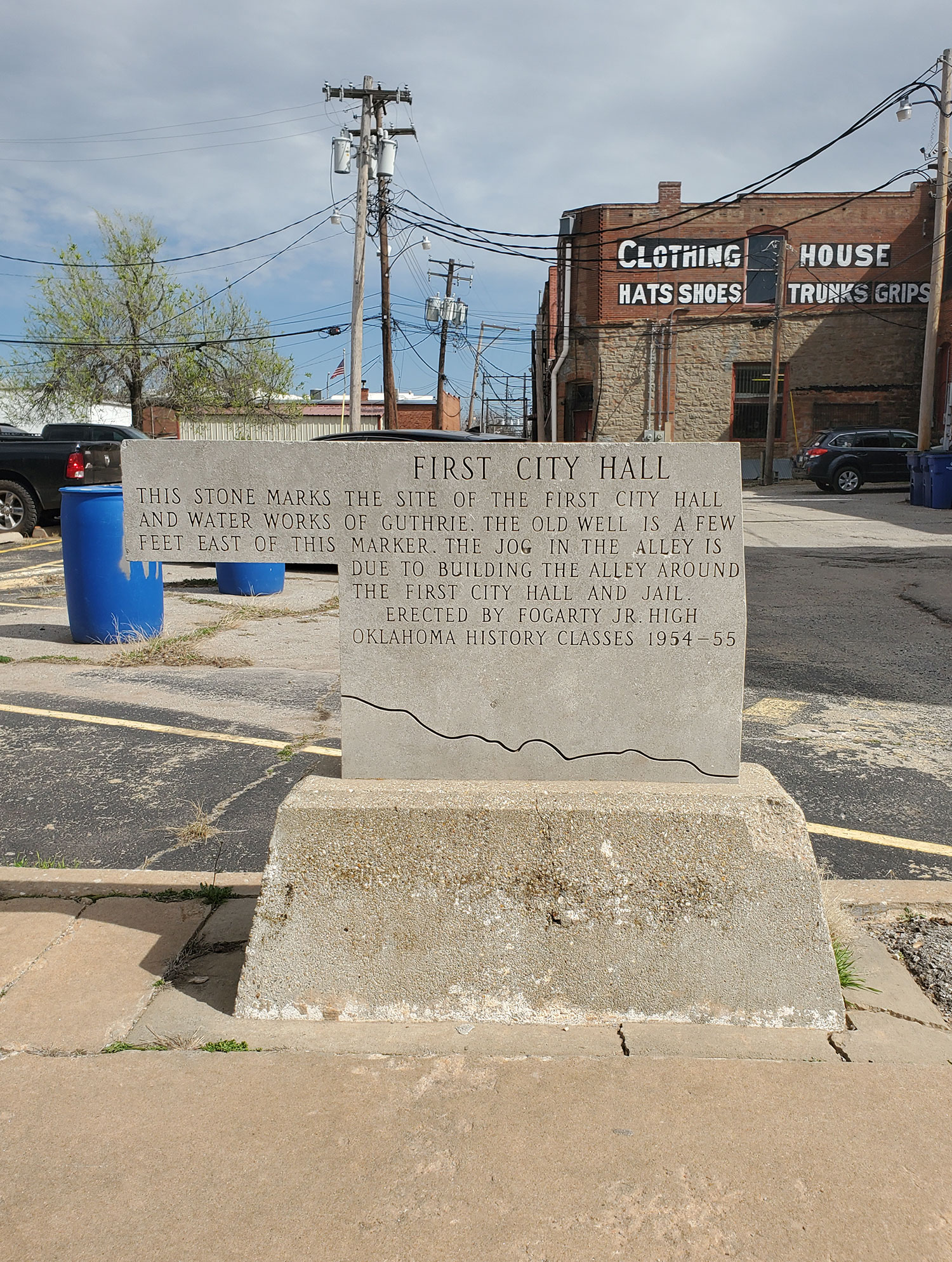
First City Hall
Logan CountyLocation: North 1st Street and West Oklahoma Avenue in Guthrie
Coordinates: 35.878517, -97.426500
Sponsored by: Fogarty Jr. High School
Material: Stone
Topics: Urban Development, Government, and Territorial Period 1861–1907
This stone marks the site of the first city hall and water works of Guthrie. The old well is a few feet east of this marker. The jog in the alley is due to the building the alley around the first city hall and jail.
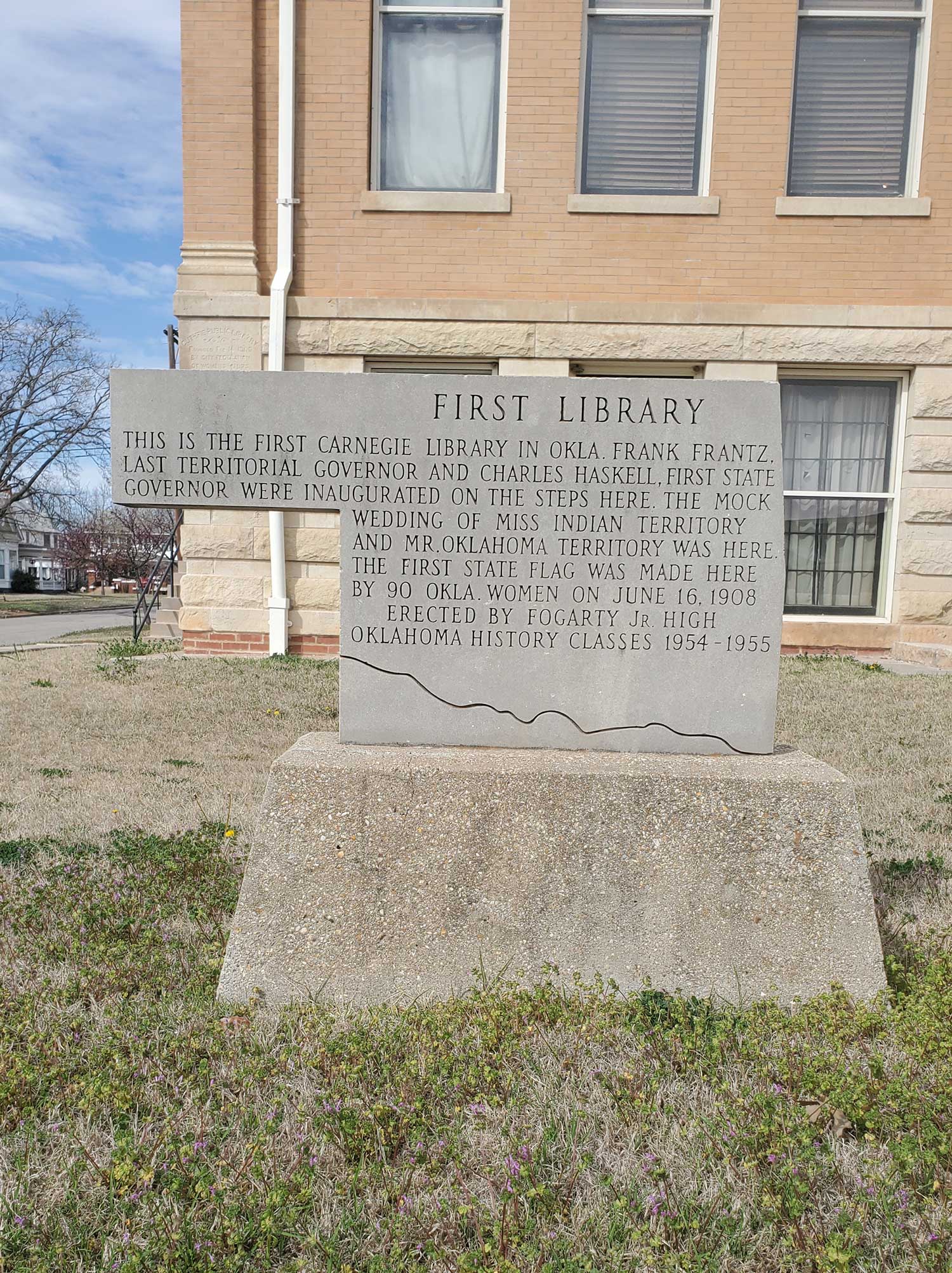
First Library
Logan CountyCoordinates: 35.878183, -97.421317
Sponsored by: Fogarty Jr. High School
Material: Stone
Topics: Urban Development, Territorial Period 1861–1907, and Social/Cultural
This is the first Carnegie Library in Okla. Frank Frantz, last Territorial Governor and Charles Haskell, first State Governor were inaugurated on the steps here. The mock wedding of Miss Indian Territory and Mr. Oklahoma Territory was here. The first state flag was made here by 90 Okla. women on June 16, 1908.

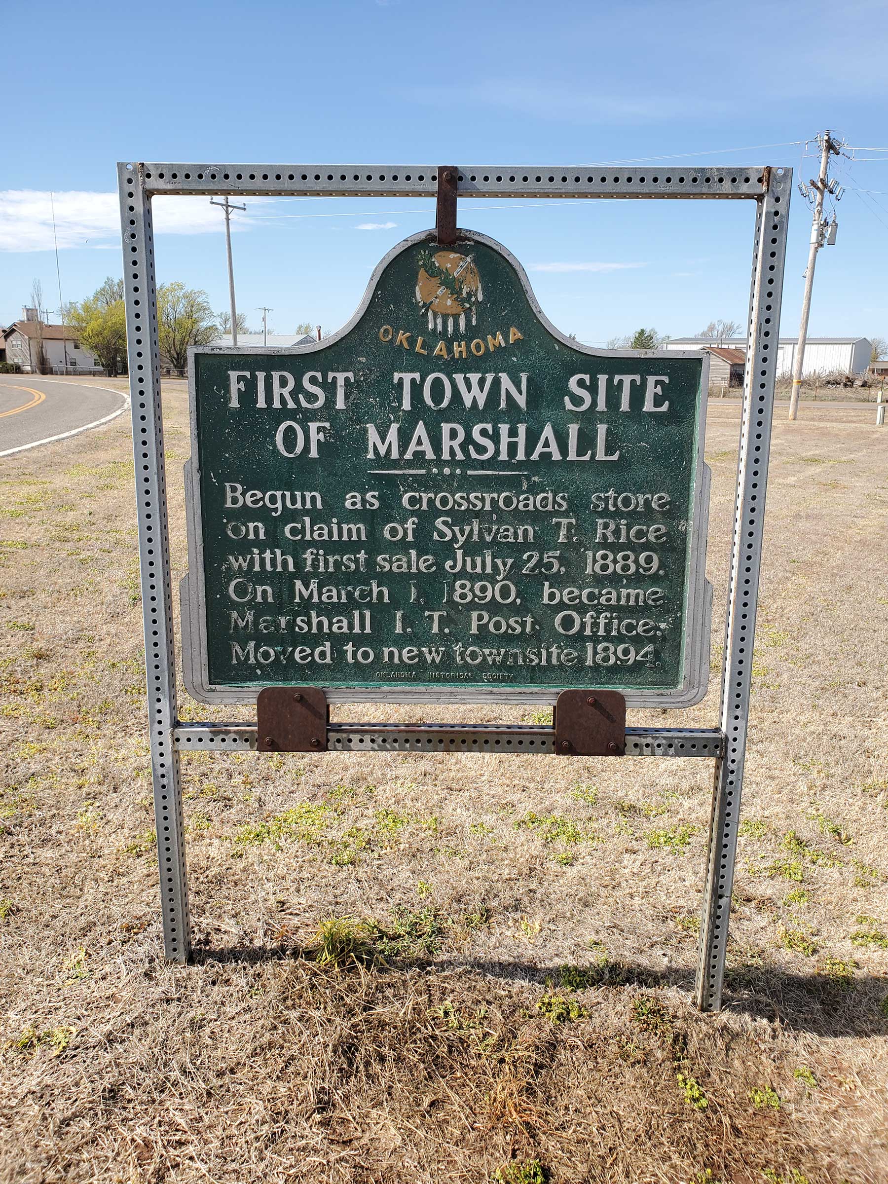
First Townsite of Marshall
Logan CountyLocation: on OK-74E in Marshall
Material: Aluminum
Note: Presumed missing
Topics: Urban Development, Government, Territorial Period 1861–1907
The town of Marshall began at the site of the Crossroads store on the claim of Sylvan T. Rice. The post office was established on March 1, 1890. The new townsite was occupied in 1894.
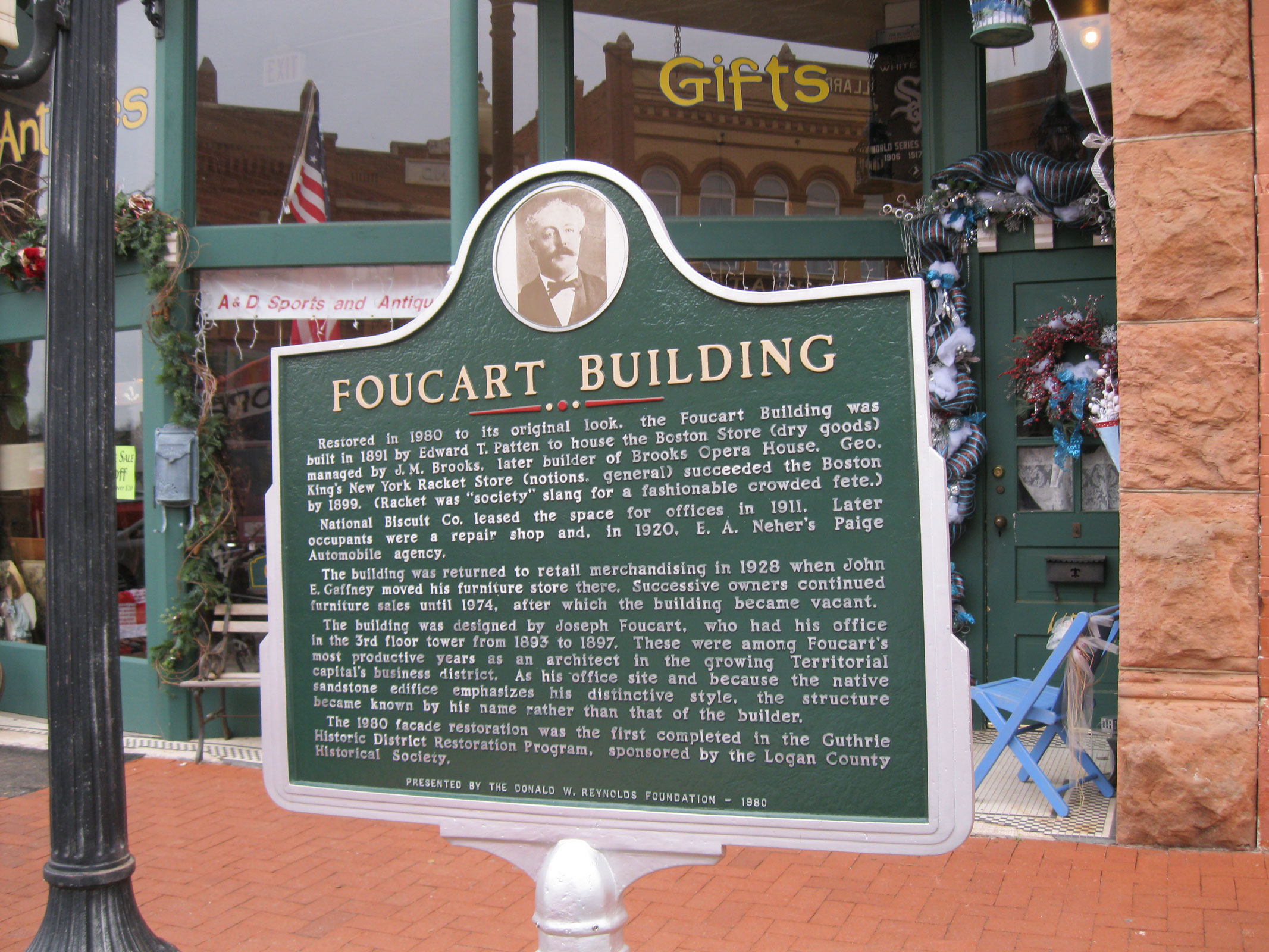
Foucart Building
Logan CountyLocation: at Harrison Avenue and Division Street in Guthrie
Coordinates: 35.876876, -97.426153
Sponsored by: Donald W. Reynolds Foundation
Material: Aluminum
Topics: Industry/Business, Retail, Urban Development, Territorial Period 1861–1907
Built in 1891, the structure housed many retail businesses and offices, including the office of building architect Joseph Foucart.
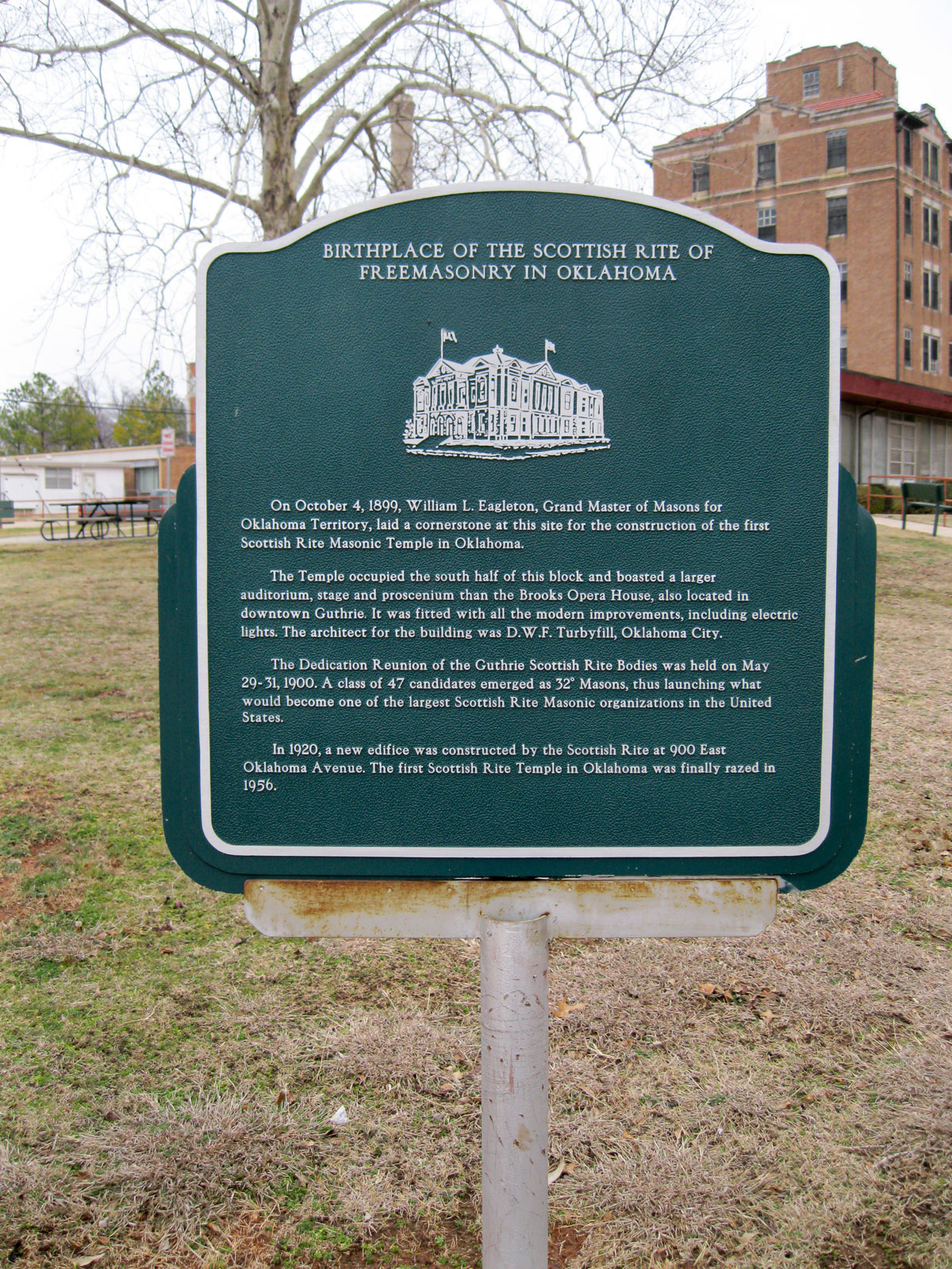
Free Masonry (Birthplace of the Scottish Rite of Freemasonry in Oklahoma)
Logan CountyLocation: at Broad Street and Harrison Avenue in Guthrie
Coordinates: 35.877125, -97.422562
Material: Aluminum
Topics: Social/Cultural, Religion/Philosophy, Territorial Period 1861–1907, Early Statehood 1907–1941
The cornerstone for Oklahoma's first Scottish Rite Masonic Temple was laid here on October 4, 1899. The building served Masons until a new edifice was constructed at 900 East Oklahoma Avenue in 1920. The old building was razed in 1956.
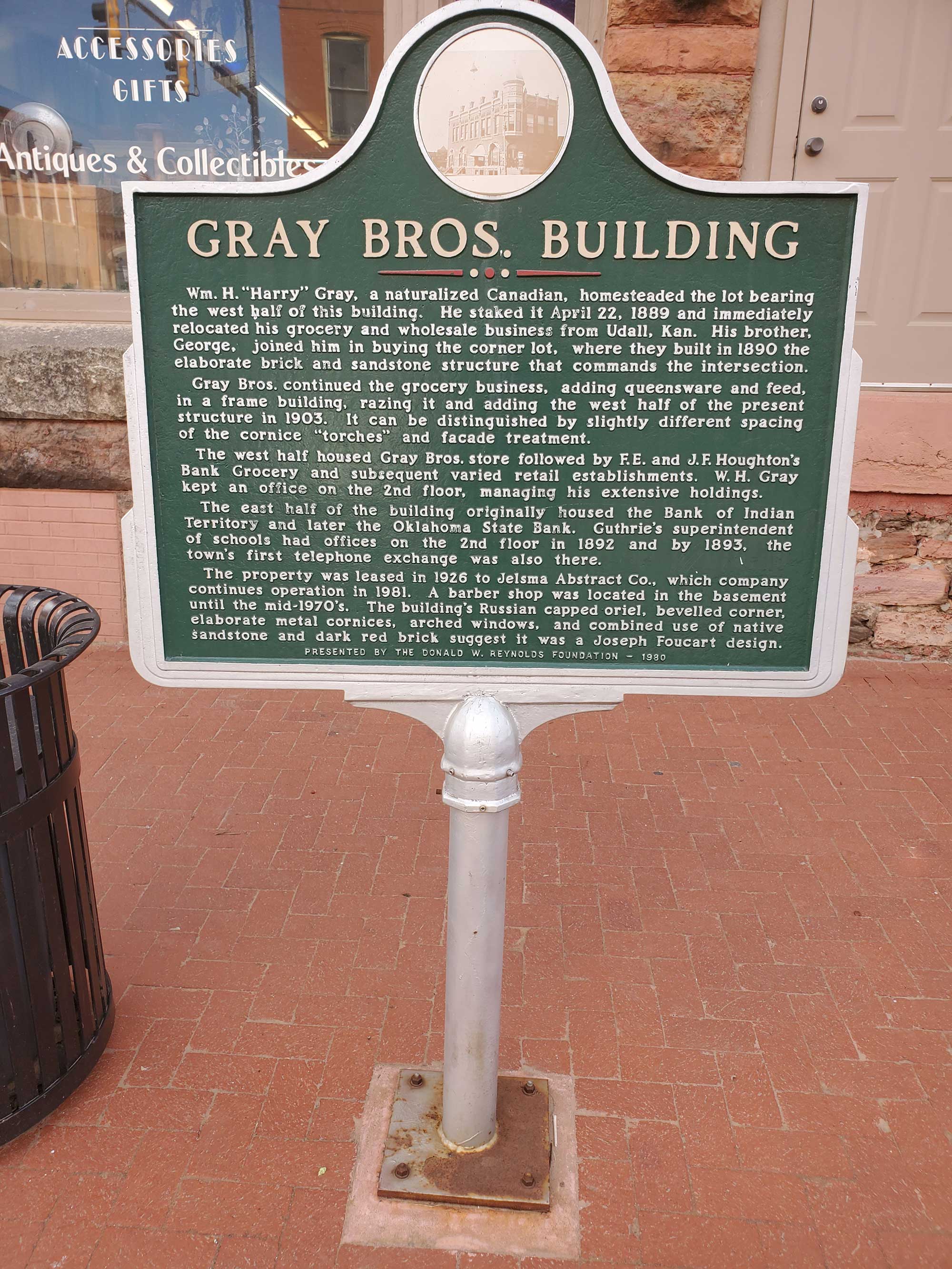
Gray Bros. Building
Logan CountyLocation: at Division Street and West Oklahoma Avenue in Guthrie
Coordinates: 35.877983, -97.425567
Sponsored by: Donald W. Reynolds Foundation
Material: Aluminum
Topics: Urban Development, Industry/Business, Territorial Period 1861–1907, Early Statehood 1907–1941
Wm. H. “Harry” Gray, a naturalized Canadian, homesteaded the lot bearing the west half of this building. He staked it April 22, 1889 and immediately relocated his grocery and wholesale business from Udall, Kan. His brother, George, joined him in buying the corner lot, where they built in 1890 the elaborate brick and sandstone structure that commands the intersection.
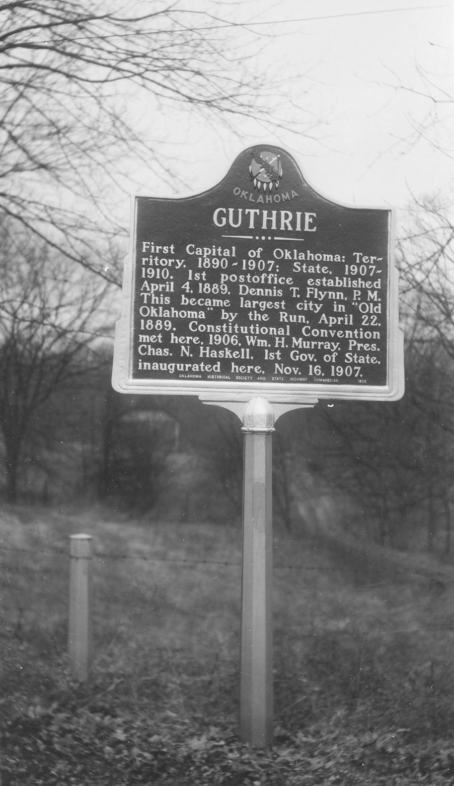
Guthrie
Logan CountyLocation: on US-77 in south Guthrie
Sponsored by: Oklahoma Department of Tourism and Daughters of the American Revolution
Note: No longer extant
Topics: Government, Territorial Period 1861–1907, Early Statehood 1907–1941, Social/Cultural
Guthrie was the capital of Oklahoma Territory and first capital of the state of Oklahoma, named in honor of Kansas Judge John Guthrie. The town's first post office opened on April 4, 1889. Guthrie was a station on the Santa Fe Railroad before the run of April 22, 1889. The constitutional convention was held here, and Charles Haskell, the state's first governor, was inaugurated here on November 16, 1907.
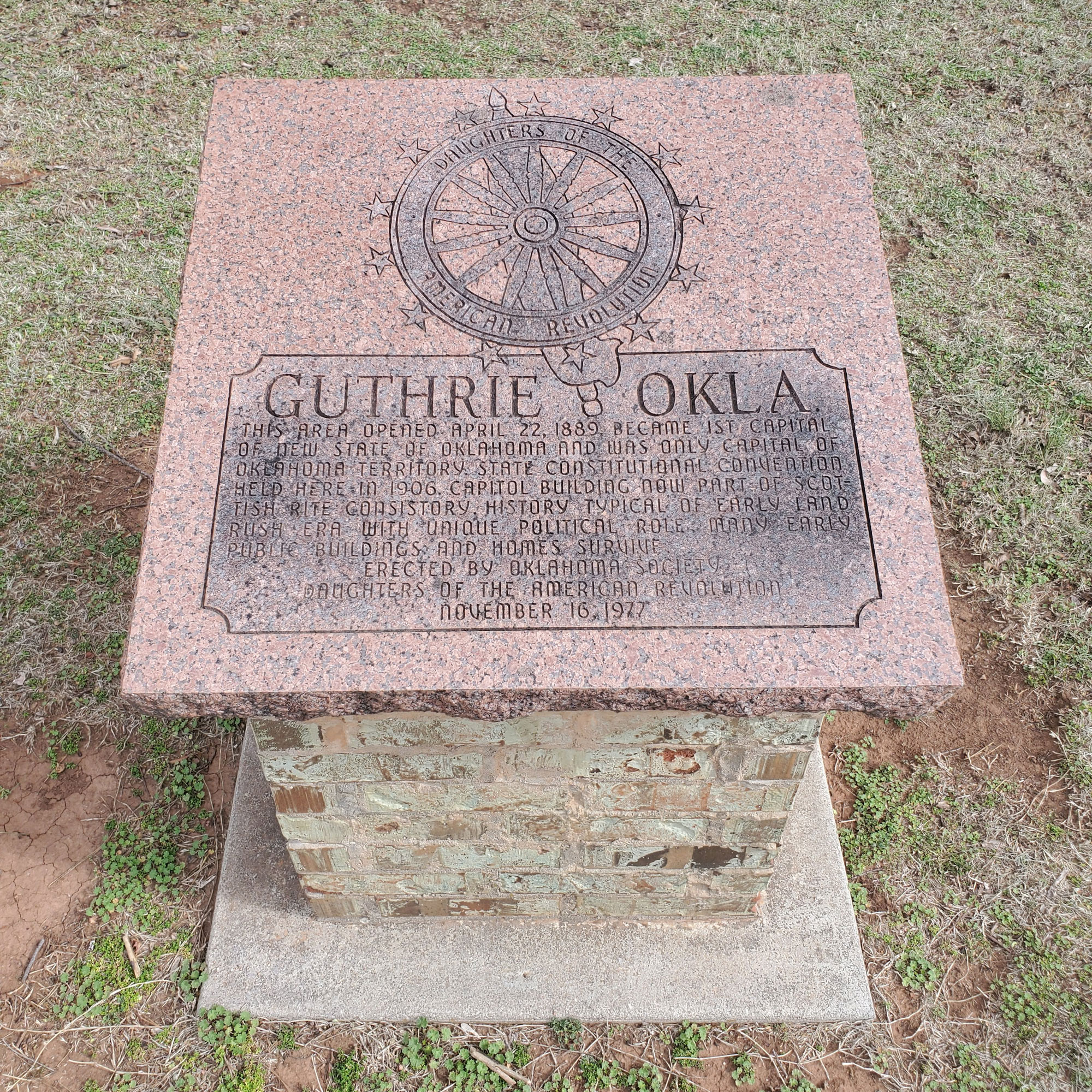
Guthrie
Logan CountyLocation: in Mineral Wells Park on south edge of Guthrie
Coordinates: 35.868752, -97.426179
Sponsored by: Daughters of the American Revolution
Material: Granite with stone base
Topics: Government, Territorial Period 1861–1907, Early Statehood 1907–1941, Social/Cultural
This area opened April 22, 1889, became 1st capital of new state of Oklahoma and was only capital of Oklahoma Territory. State constitutional convention held here in 1906. Capitol Building now part of Scottish Rite Consistory. History typical of early land rush area with unique political role. Many early public buildings and homes survive.
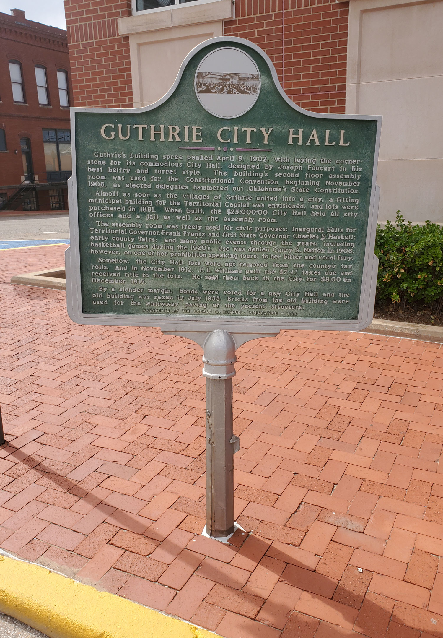
Guthrie City Hall
Logan CountyLocation: at Second Street and Oklahoma Avenue in Guthrie
Coordinates: 35.878163, -97.427701
Sponsored by: Donald W. Reynolds Foundation
Material: Aluminum
Topics: Territorial Period 1861–1907, Government
The cornerstone for the Guthrie City Hall building was laid on April 9, 1902. The second floor of the structure was used for Oklahoma's Constitutional Convention beginning in November 1906. The city hall was razed in 1955, and a new building was constructed.
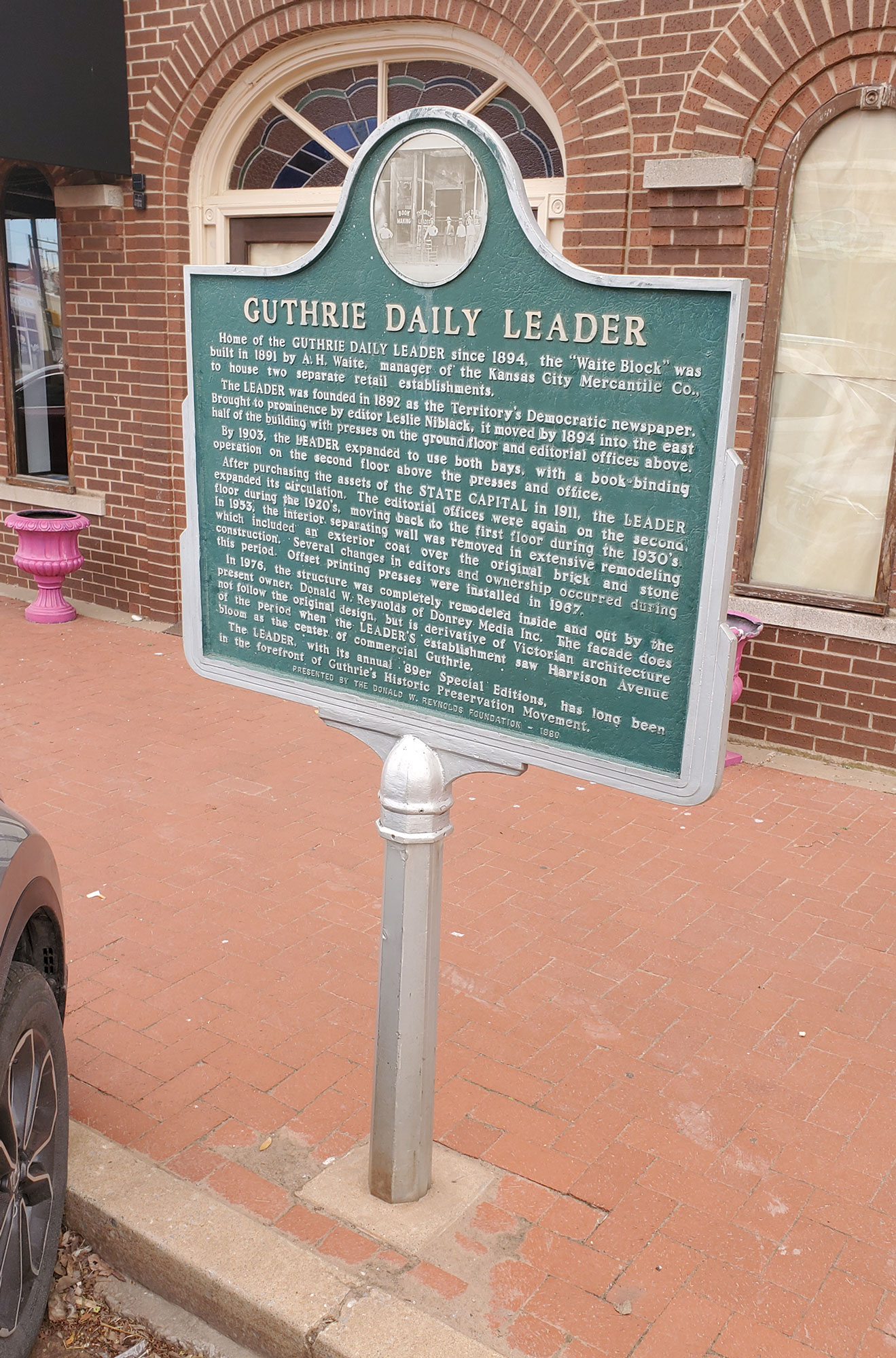
Guthrie Daily Leader
Logan CountyLocation: at Division Street and Harrison Avenue in Guthrie
Coordinates: 35.876916, -97.425855
Sponsored by: Donald W. Reynolds Foundation
Material: Aluminum
Topics: Mass Communication, Territorial Period 1861–1907
Built in 1891, the building became home to the Guthrie Daily Leader three years later. The paper was the prominent Democratic newspaper in Oklahoma Territory. The structure was completely remodeled in 1976.
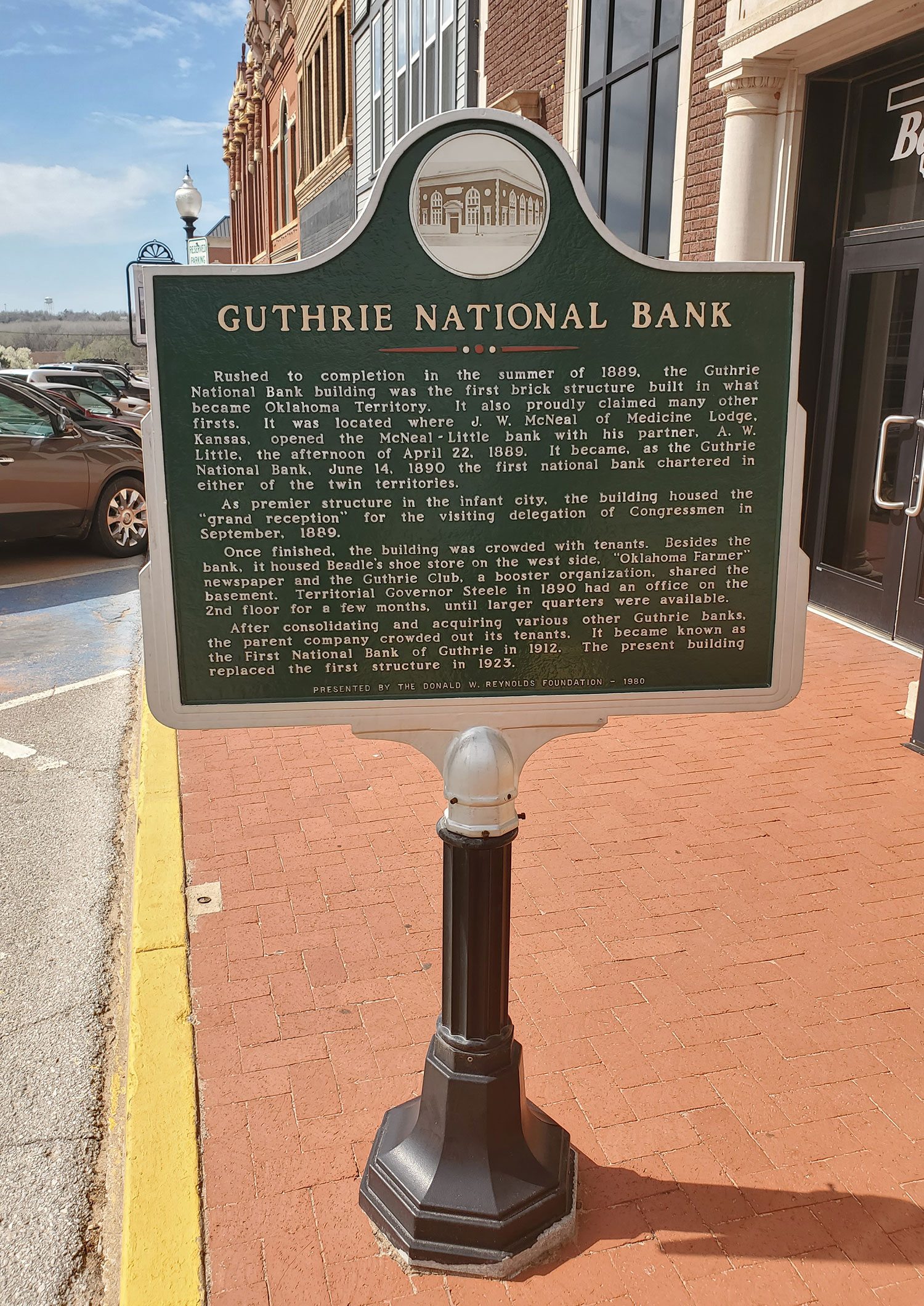
Guthrie National Bank
Logan CountyLocation: at First Street and Oklahoma Avenue in Guthrie
Coordinates: 35.878103, -97.426731
Material: Aluminum
Topics: Industry/Business, Urban Development, Government, Territorial Period 1861–1907, Early Statehood 1907–1941
The bank was the first brick structure built in what would become Oklahoma Territory. Completed in the summer of 1889, the building housed the grand reception for a visiting congressional delegation in September of that year. In 1923, the present building replaced the original structure. The Guthrie National Bank was the first national bank chartered in either of the twin territories.
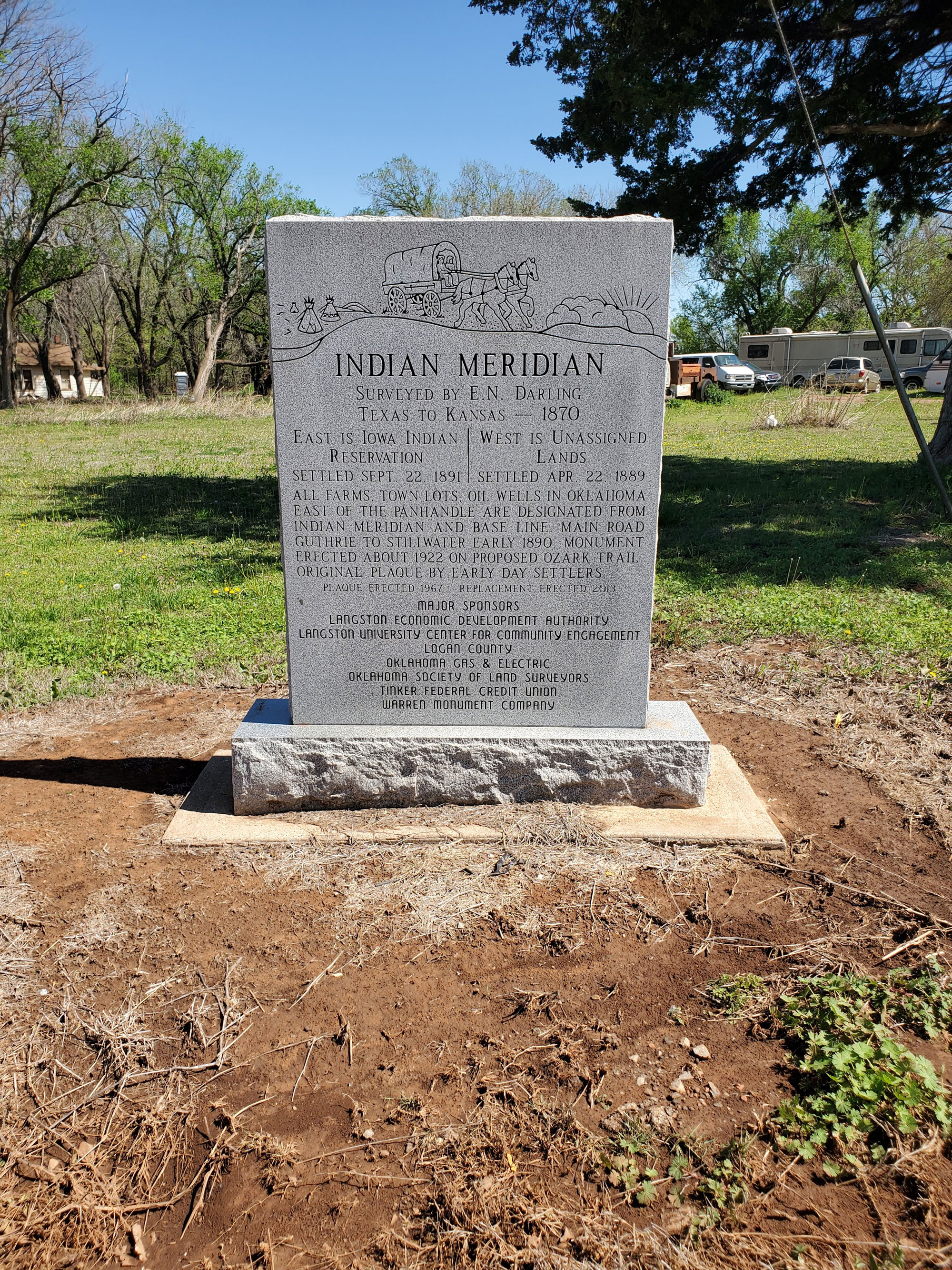
Indian Meridian
Logan CountyLocation: northeast of intersection of Logan Road and Washington Avenue in Langston
Coordinates: 35.942161, -97.246934
Material: Granite
Surveyed by E.N. Darling, Texas to Kansas, 1870. East is Iowa Indian Reservation (settled September 22, 1891). West is Unassianged Lands (settled Apr 22, 1889). All farms, town lots, oil wells in Oklahoma east of the Panhandle are designated from Indian Meridian and Base Line. Main road Guthrie to Stillwater early 1890. Monument erected About 1922 on proposed Ozark Trail. Original plaque by Early Day Settlers. Plaque erected 1967. Replacement erected 2013.
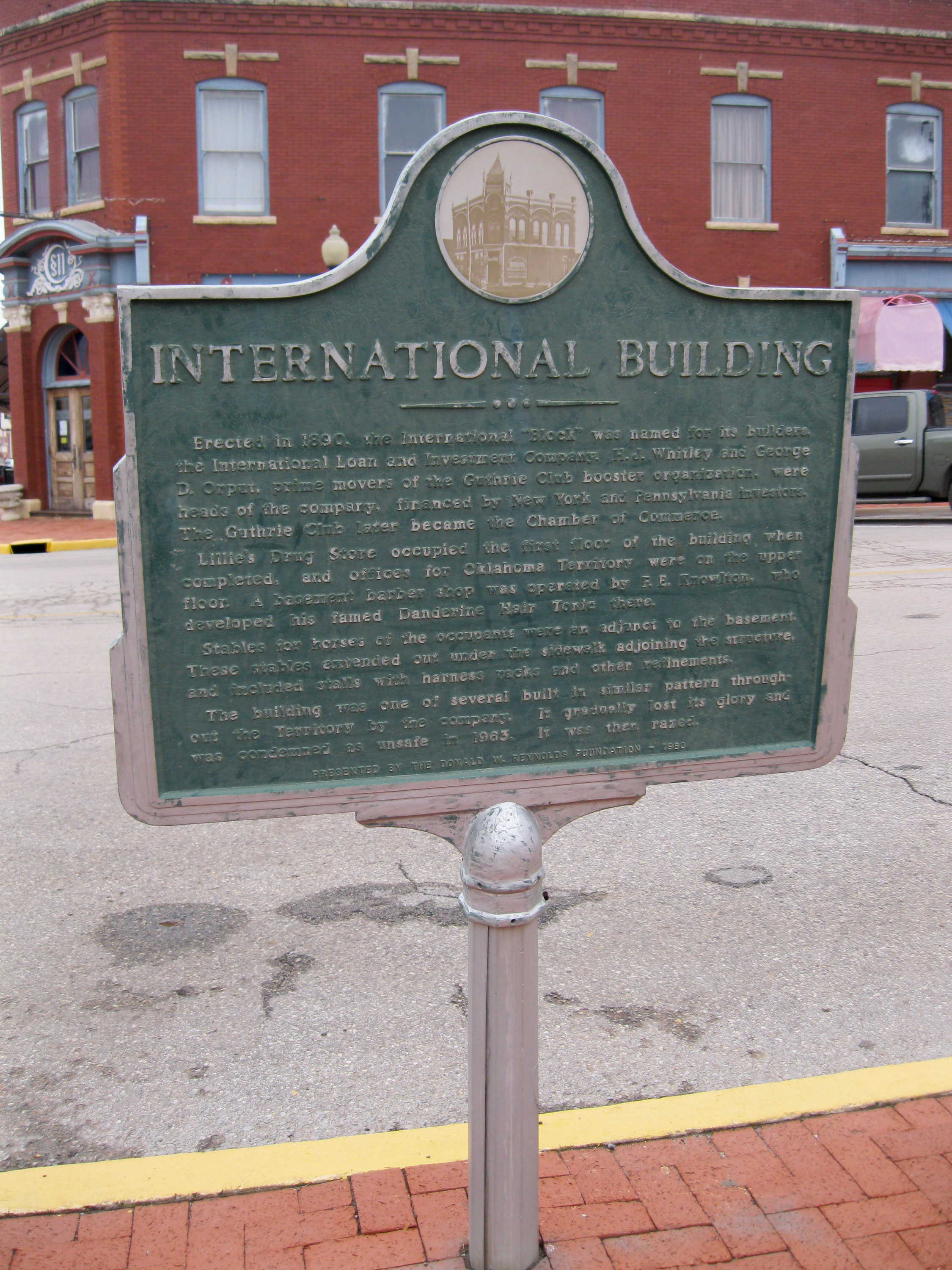
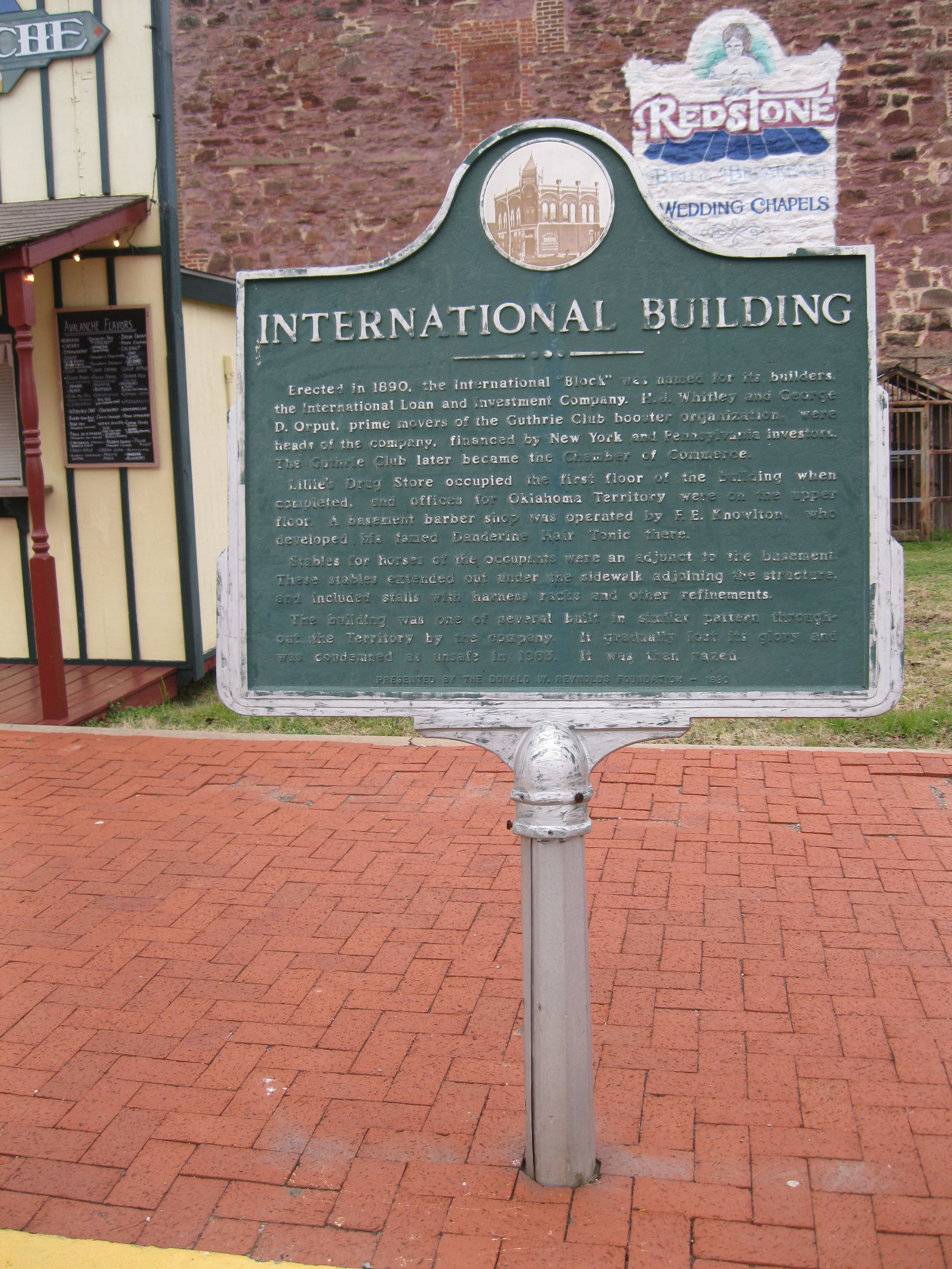
International Building
Logan CountyLocation: at Second Street and Harrison Avenue in Guthrie
Coordinates: 35.876901, -97.427370
Sponsored by: Donald W. Reynolds Foundation
Material: Aluminum
Topics: Retail, Territorial Period 1861–1907, Manufacturing
This building housed numerous retail establishments when it was erected in 1890. Barber F.E. Knowlton developed his famous Danderine Hair Tonic here. The building was razed in the 1960s.
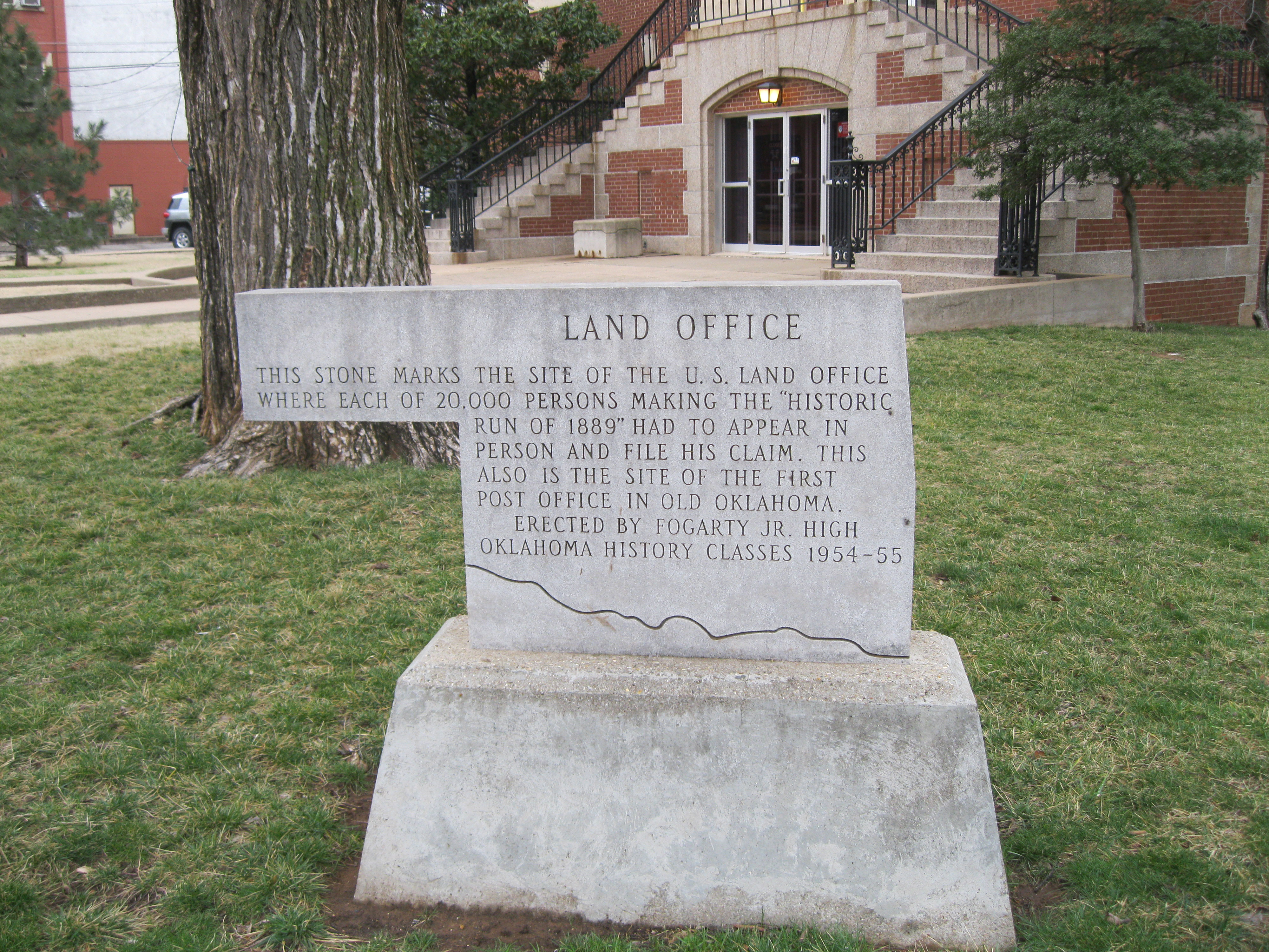
Land Office
Logan CountyLocation: at Second Street and Oklahoma Avenue in Guthrie
Coordinates: 35.877894, -97.426715
Sponsored by: Fogarty Jr. High School
Material: Aluminum
Topics: Land Openings, Settlement Patterns, Government, Territorial Period 1861–1907
On this site stood the federal government's land office where each of the 20,000 persons making the Land Run of 1889 had to appear and file his claim. This was also the site of the first post office in Oklahoma Territory.
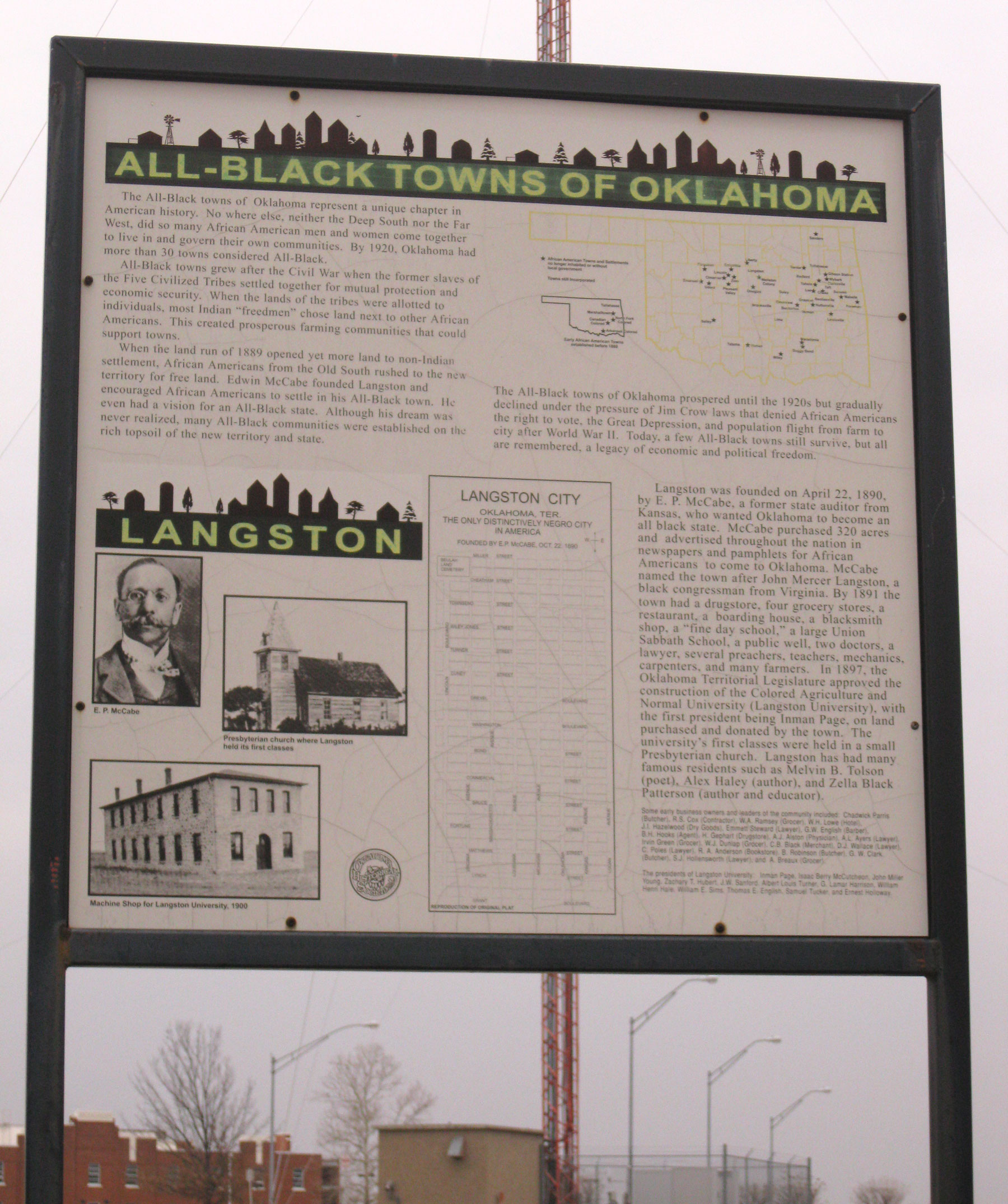
Langston
Logan CountyLocation: on Langston University campus in Langston
Coordinates: 35.942474, -97.260493
Sponsored by: Oklahoma Historical Society
Material: Other (Interpretive Panel)
Topics: Ethnic Diversity, Land Openings, Settlement Patterns, Urban Development, Education
Langston is one of thirteen All-Black towns, out of more than fifty that once existed, remaining in Oklahoma. While Tullahassee is reportedly the oldest, most were established between 1889 and 1907 as African Americans sought security and control of their own destiny in a segregated world. Most of the towns began to decline in the 1920s and 1930s as rural African Americans faced economic hardships and began to move to urban areas. Langston was organized in 1890 by E. P. McCabe, who also boosted Oklahoma as an All-Black state. It takes its name from John M. Langston, a well-known educator and member of Congress. Langston became home to the Colored Agricultural and Normal University (Langston University) in 1897.
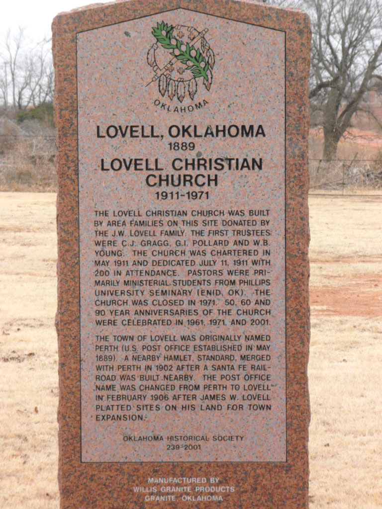
Lovell
Logan CountyLocation: at intersection of OK-74D and Main Street in Lovell
Coordinates: 36.057936, -97.635495
Material: Granite
Topics: Religion/Philosophy, Social/Cultural, Urban Development, Government, Transportation, Settlement Patterns
The Lovell Christian Church was built by area families on this site donated by the J. W. Lovell Family. The first trustees were C. J. Gragg, G. I. Pollard and W. B. Young. The church was chartered in May 1911 and dedicated on July 11, 1911, with 200 in attendance. Pastors were primarily ministerial students from Phillips University Seminary (Enid, OK). The church was closed in 1971. 50-, 60- and 90-year anniversaries of the church were celebrated in 1961, 1971, and 2001. The Town of Lovell was originally named Perth (US Post Office established in May 1889). A nearby hamlet, Standard, merged with Perth in 1902 after a Santa Fe Railroad was built nearby. The Post Office name was changed from Perth to Lovell in February 1906 after James W. Lovell platted sites on his land for town expansion.
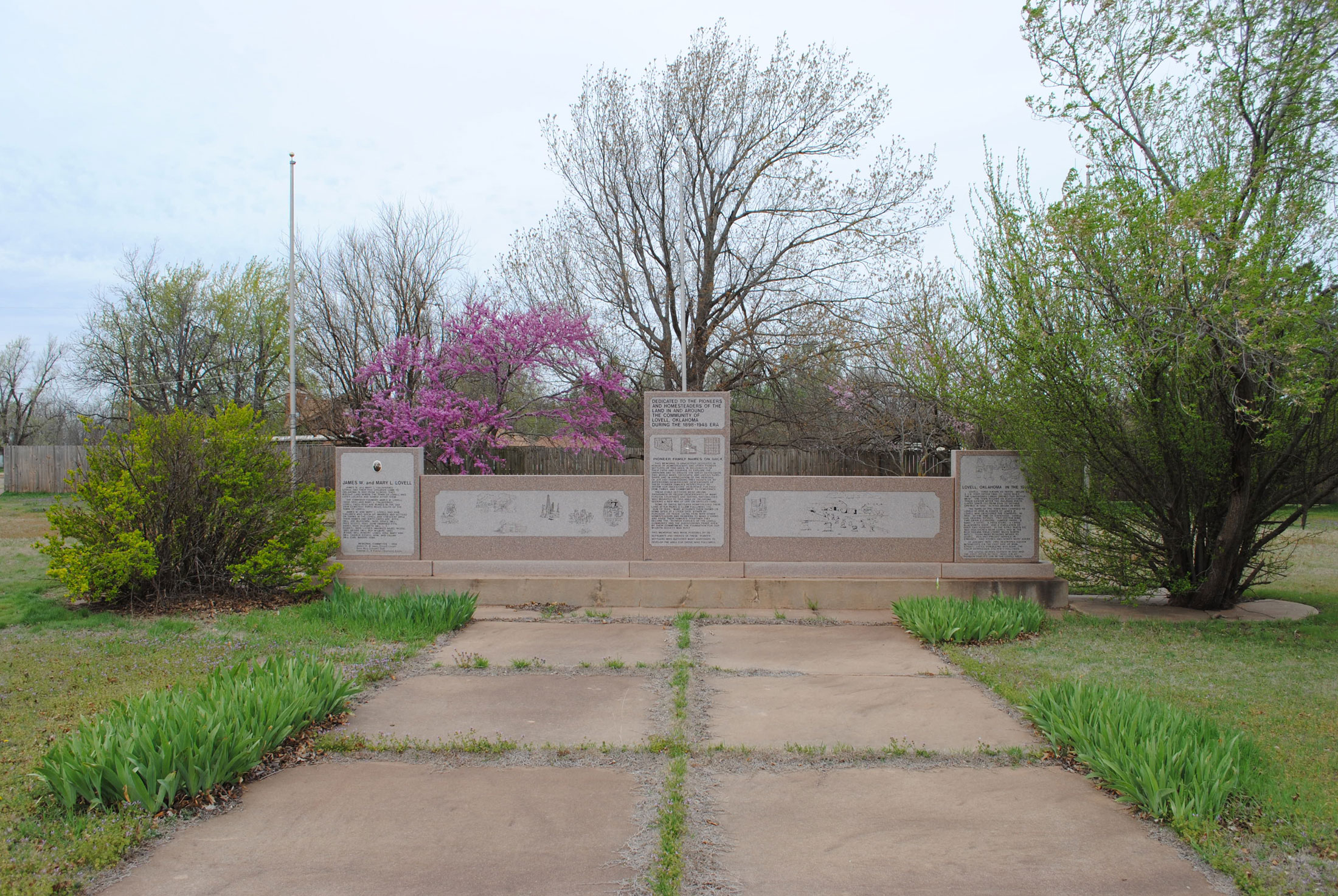


Lovell Pioneers and Homesteaders
Logan CountyLocation: in Lovell, at intersection of OK-74D and Main Street
Coordinates: 36.05749, -97.63567
Sponsored by: Lovell Memorial Committee
Material: Granite
Topics: Settlement Patterns, Land Openings, Territorial Period 1861–1907, Early Statehood 1907–1941
Dedicated in honor of homesteaders and other pioneer settlers of this area. In recognition of their faith and courage to explore the unknown and to endure the Great Depression, two world wars, droughts, and untold hardships, and in appreciation of the heritage of joy and thanksgiving they passed on to succeeding generations. Descendants of these pioneer families respectfully reaffirm our ancestors reverence for freedom, family, and commitment to democracy.
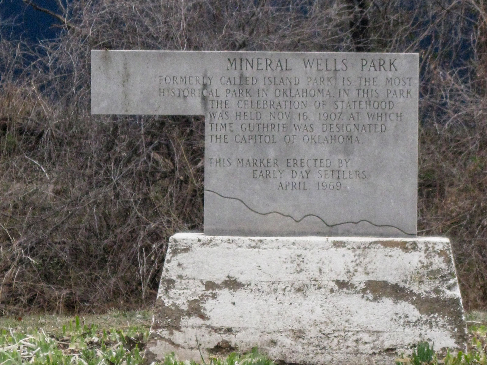
Mineral Wells Park
Logan CountyLocation: in Mineral Wells Park on south edge of Guthrie (DAR)
Coordinates: 35.869066, -97.425895
Sponsored by: Early Day Settlers
Material: Stone
Topics: Water, Social/Cultural, Recreational/Service, Government, Early Statehood 1907–1941
Originally called Island Park, this site received its name from the different waters developed there that reportedly had healing benefits. A huge picnic was held in the park after Oklahoma officially became the 46th state of the Union on November 16, 1907. It also was a favorite camp site for large civic and family groups.
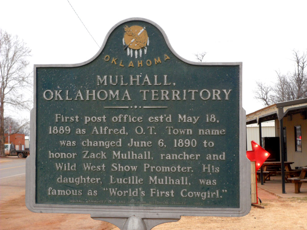
Mulhall
Logan CountyLocation: on US-77 in Mulhall
Coordinates: 36.065050, -97.406950
Material: Aluminum
Topics: Government, Territorial Period 1861–1907, Folklife, Ranching, Arts
The post office of Alfred was established here in 1889. The town name was changed the following year to honor Zack Mulhall, an area rancher who also started his own Wild West Show.
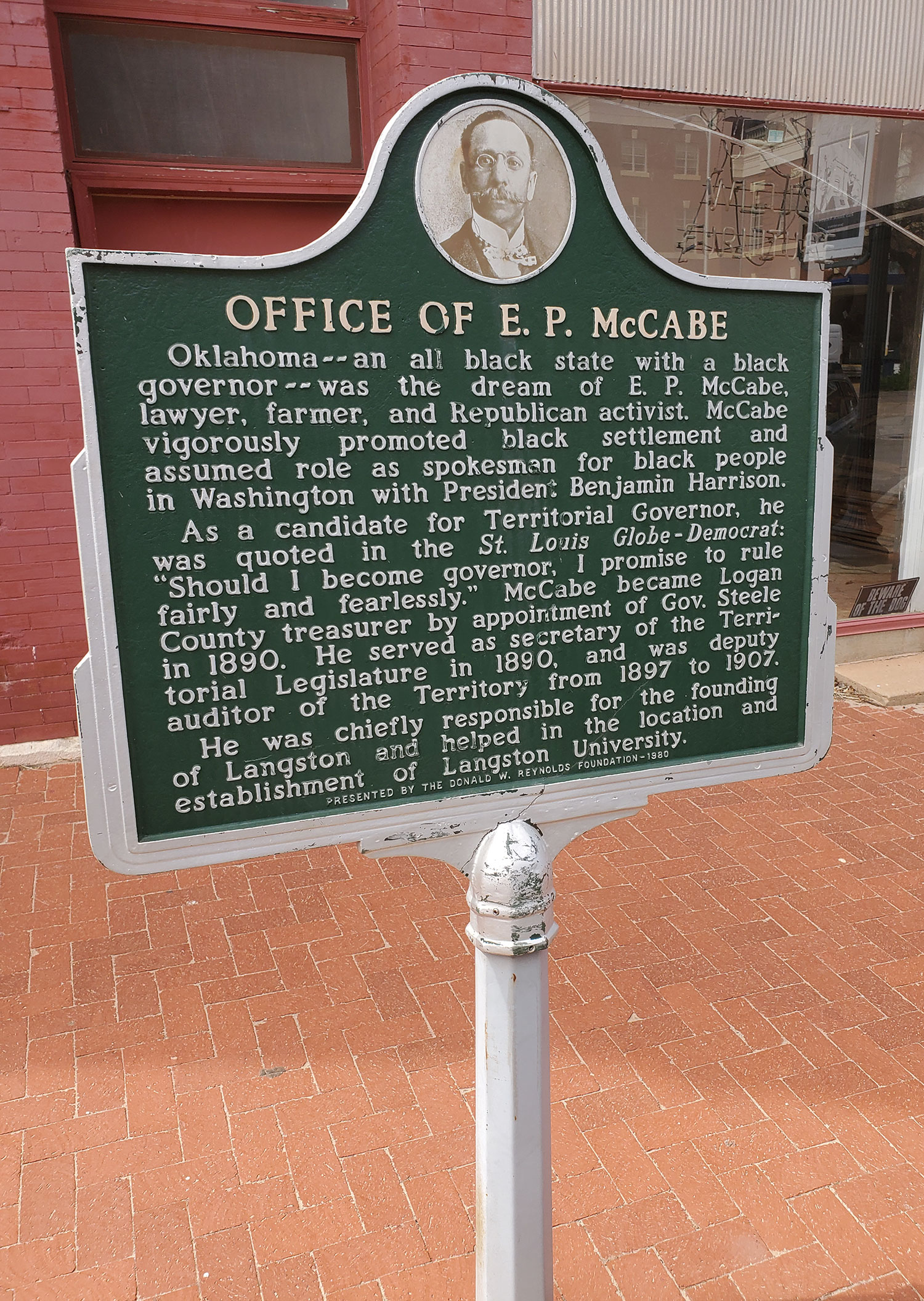
Office of E. P. McCabe
Logan CountyLocation: at South 2nd Street and West Harrison Avenue in Guthrie
Coordinates: 35.877367, -97.427667
Sponsored by: Donald W. Reynolds Foundation
Material: Aluminum
Topics: Ethnic Diversity, Government, and Territorial Period 1861–1907
Oklahoma–an all black state with a black governor–was the dream of E. P. McCabe, lawyer, farmer, and Republican activist. McCabe vigorously promoted black settlement and assumed role as spokesman for black people in Washington with President Benjamin Harrison. As a candidate for Territorial Governor, he was quoted in the St. Louis Globe - Democrat: Should I become governor, I promise to rule fairly and fearlessly." McCabe became Logan County treasurer by appointment of Gov. Steele in 1890. He served as secretary of the Territorial Legislature in 1890. and was deputy auditor of the Territory from 1897 to 1907. He was chiefly responsible for the founding of Langston and helped in the location and establishment of Langston University.
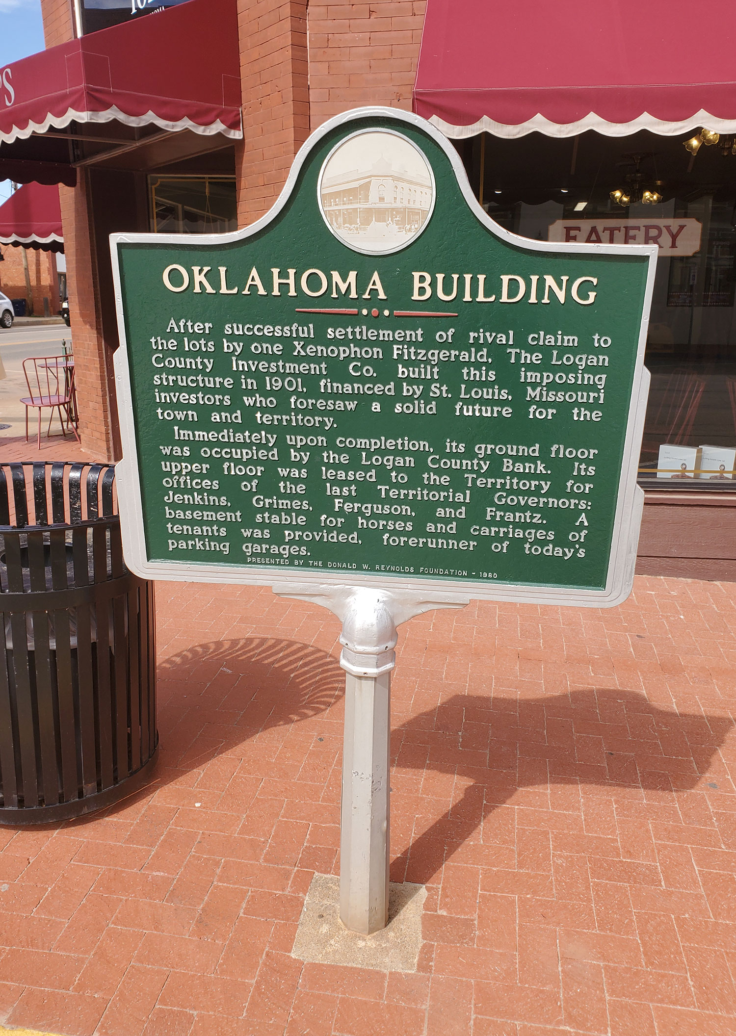
Oklahoma Building
Logan CountyLocation: at Division Street and Oklahoma Avenue in Guthrie
Coordinates: 35.878112, -97.425190
Sponsored by: Donald W. Reynolds Foundation
Material: Aluminum
Topics: Government, Territorial Period 1861–1907, Transportation
Completed in 1901, this imposing structure was leased to Oklahoma Territory for office space for the final four territorial governors. A basement stable for horses and carriages was the forerunner of today's parking garages.
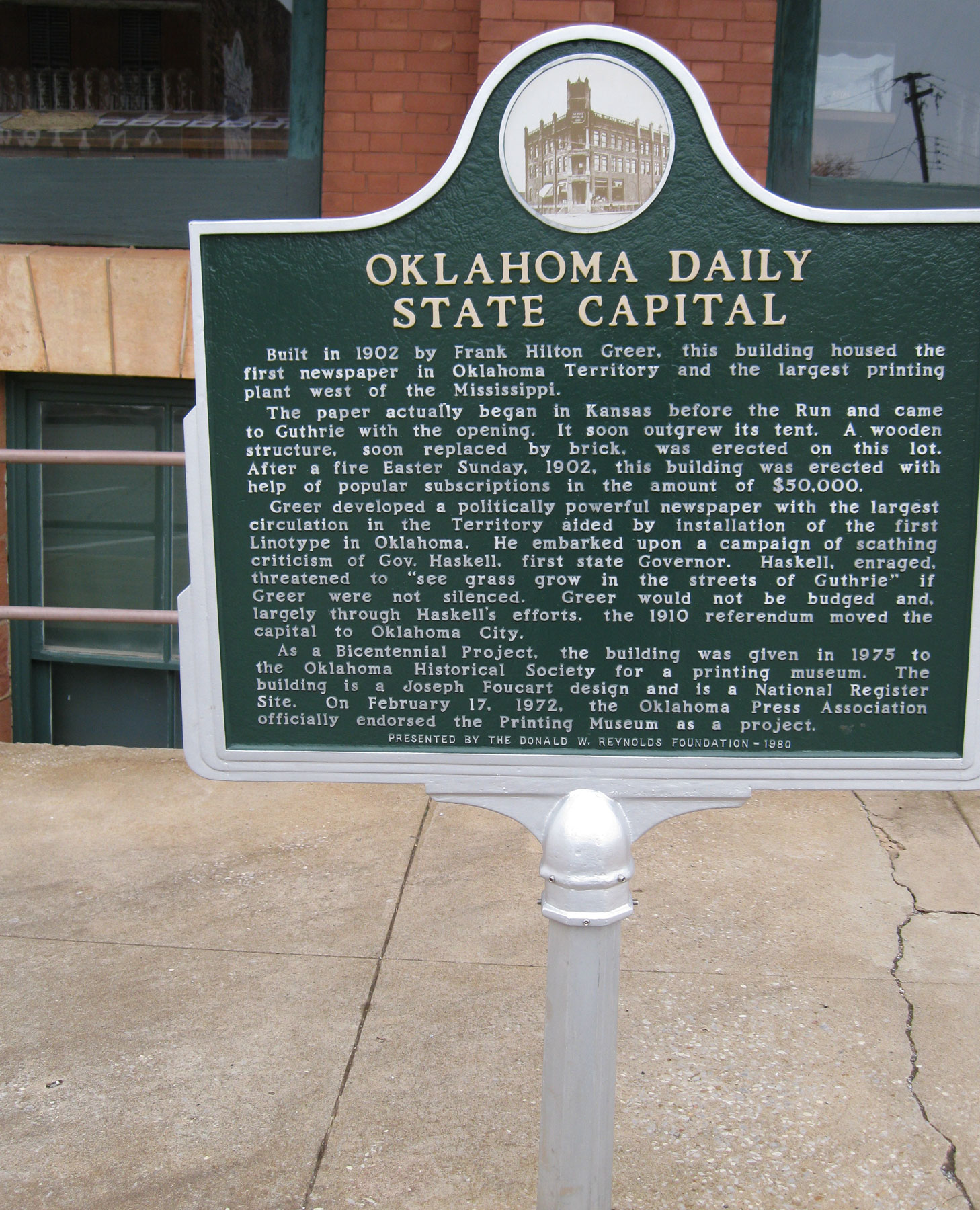
Oklahoma Daily State Capital
Logan CountyLocation: at Second Street and Harrison Avenue in Guthrie
Coordinates: 35.876806, -97.427681
Sponsored by: Donald W. Reynolds Foundation
Material: Aluminum
Topics: Mass Communication, Territorial Period 1861–1907
This building, completed in 1902, housed Oklahoma Territory's first newspaper and the largest printing plant west of the Mississippi River. In 1975, the building was given to the Oklahoma Historical Society.
Oklahoma Territorial Museum
Logan CountyLocation: at 402 East Oklahoma Street in Guthrie
Material: Other (highway sign)
Note: Missing
Topics: Government, Social/Cultural, Territorial Period 1861–1907, Early Statehood 1907–1941
Portraying the vast panorama of the heritage of Oklahoma Territory, the museum is adjacent to the oldest Carnegie Library in the state. It was on this location that the last territorial governor, Frank Frantz, and the first state governor, Charles N. Haskell, were inaugurated. The structure is one of the best examples of territorial-era architecture
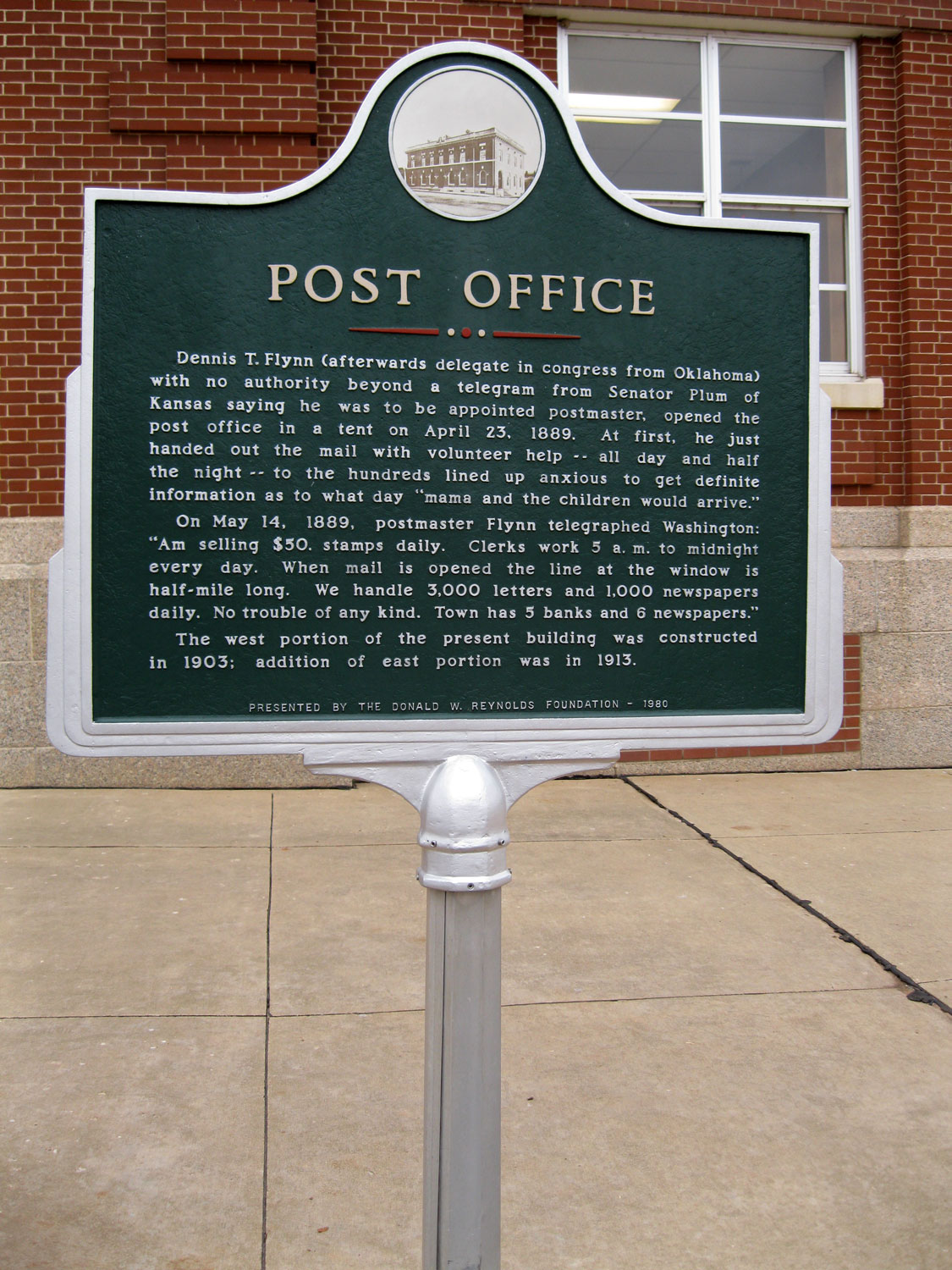
Post Office
Logan CountyLocation: at Second Street and Oklahoma Avenue in Guthrie
Coordinates: 35.877950, -97.427400
Sponsored by: Donald W. Reynolds Foundation
Material: Aluminum
Topics: Government, Mass Communication, Territorial Period 1861–1907, Social/Cultural
Dennis T. Flynn opened the Guthrie post office in a tent on April 23, 1889, the day after the famous run of 1889. With volunteer help, he handed out the mail. Within a few weeks, the post office was handling 3,000 letters and 1,000 newspapers daily.
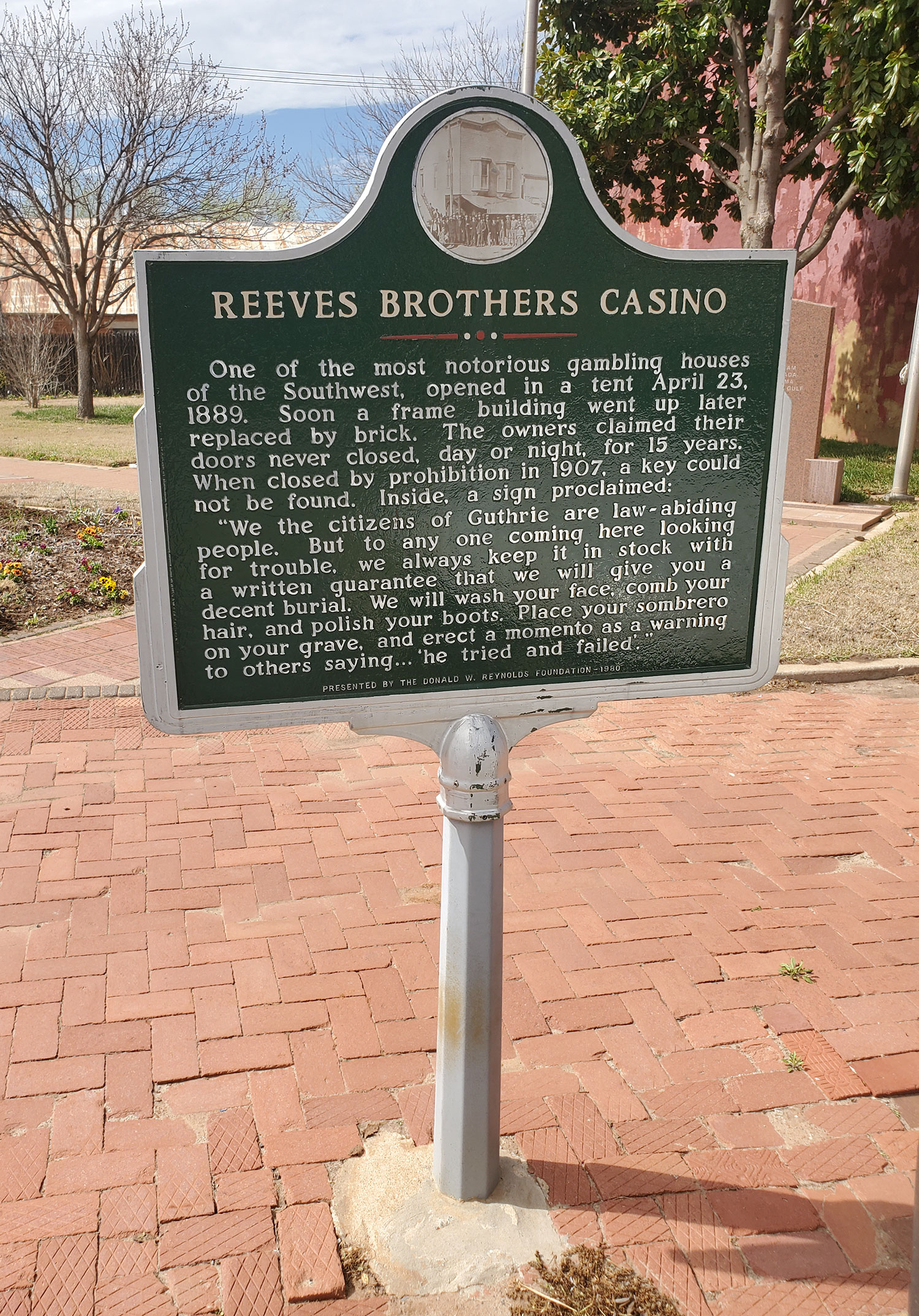
Reeves Brothers Casino
Logan CountyLocation: at Second Street and Harrison Avenue in Guthrie
Coordinates: 35.877200, -97.427683
Sponsored by: Donald W. Reynolds Foundation
Material: Aluminum
Topics: Social/Cultural, Territorial Period 1861–1907, Industry/Business
This notorious gambling house opened in a tent on April 23, 1889. It was later housed in a frame building which gave way to a brick structure. For fifteen years, until prohibition at statehood, the casino never closed its doors, day or night.
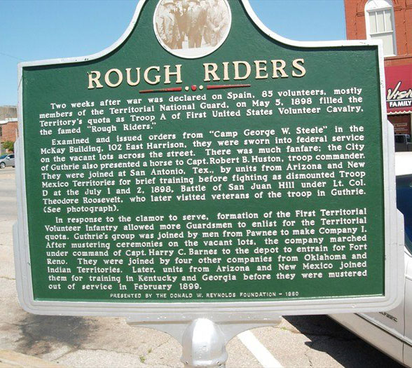
Rough Riders
Logan CountyLocation: 1/2 block east of Hwy-77 on Harrison Street, Guthrie, on south side
Coordinates: 35.876900, -97.424900
Sponsored by: Donald W. Reynolds Foundation
Material: Aluminum
Two weeks after war was declared on Spain, 85 volunteers, mostly members of the Territorial National Guard, on May 5, 1898, filled the Territory's quota as Troop A, 1st United States Volunteer Calvary, the famed "Rough Riders
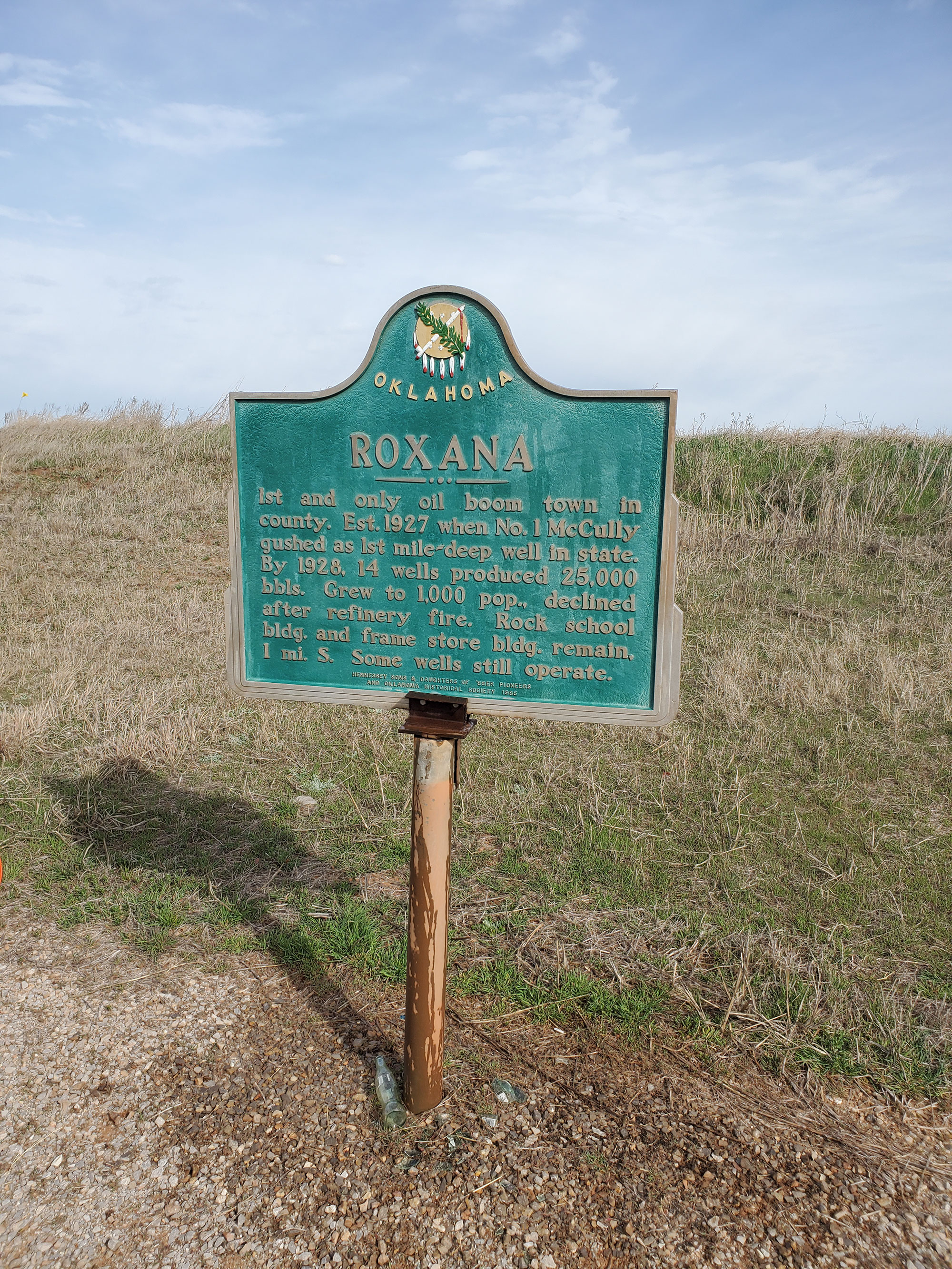
Roxana
Logan CountyLocation: on OK-51, one mile east of Kingfisher County line
Coordinates: 36.116229, -97.659737
Sponsored by: Donald W. Reynolds Foundation
Material: Aluminum
Topics: Urban Development, Industry/Business, Petroleum, Natural Resources, Early Statehood 1907–1941
Logan County's only boom town was established in 1927 when the No. 1 McCully gushed in as the first mile-deep well in the state. The town declined after a refinery fire in the early 1930s.
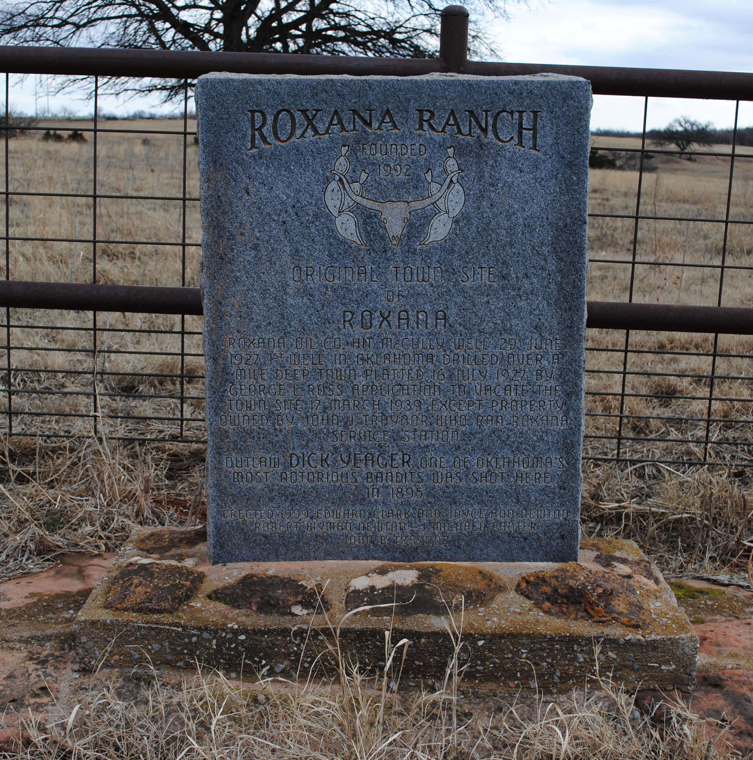
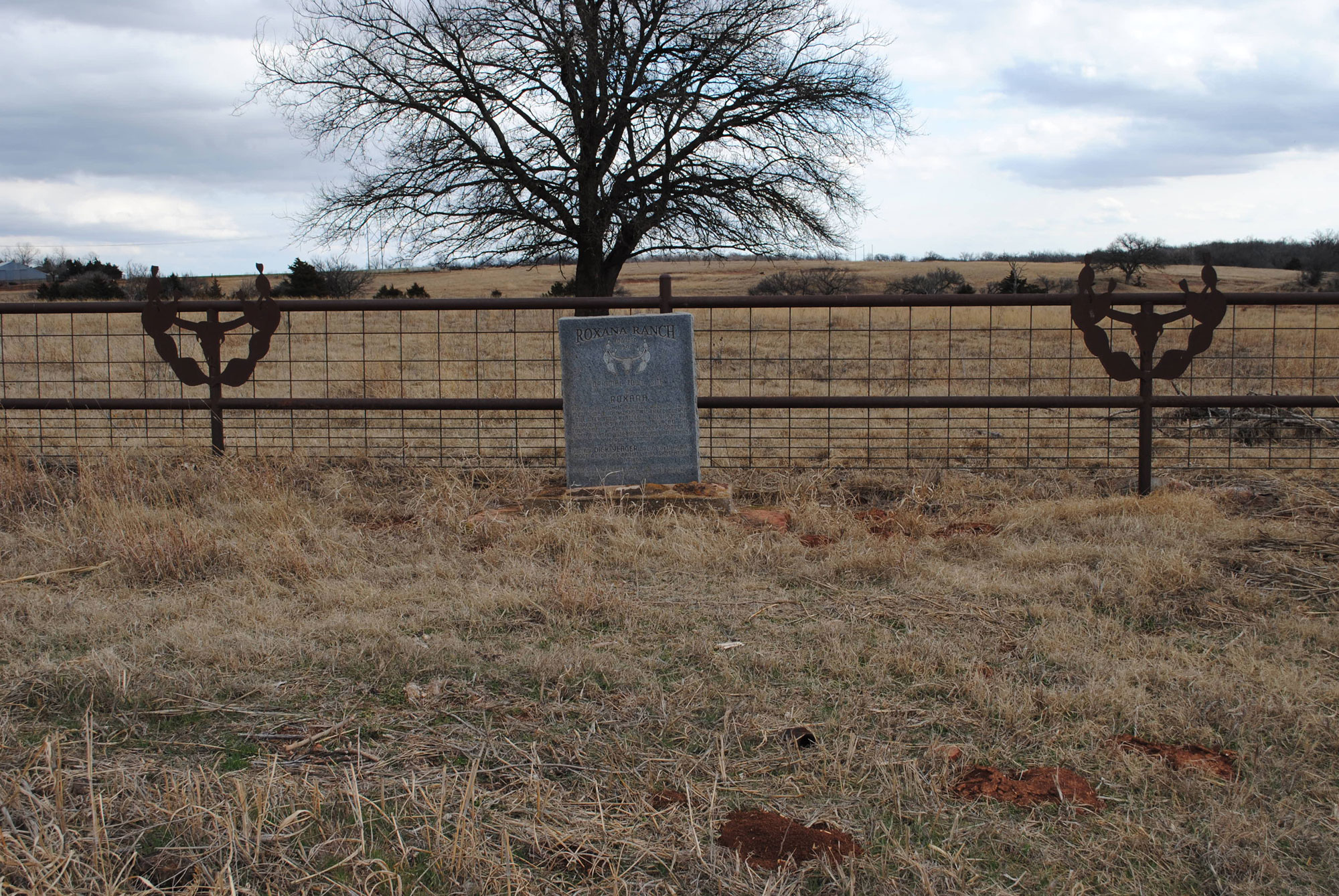
Roxana Ranch and Original Townsite of Roxana
Logan CountyLocation: one mile south of OK-51 on N300 Rd
Coordinates: 36.10155, -97.65721
Sponsored by: Private
Material: Granite
Topics: Urban Development, Industry/Business, Petroleum, Natural Resources, Early Statehood 1907–1942
Roxana Oil Co. hit McCully well 29 June 1927. First well in Oklahoma drilled over a mile deep. Town platted 16 July 1927 by George L. Ross. Application to vacate the town site 17 March 1939 except property owned by John J. Traynor, who ran Roxana Service Station. Roxana Ranch founded in 1992.
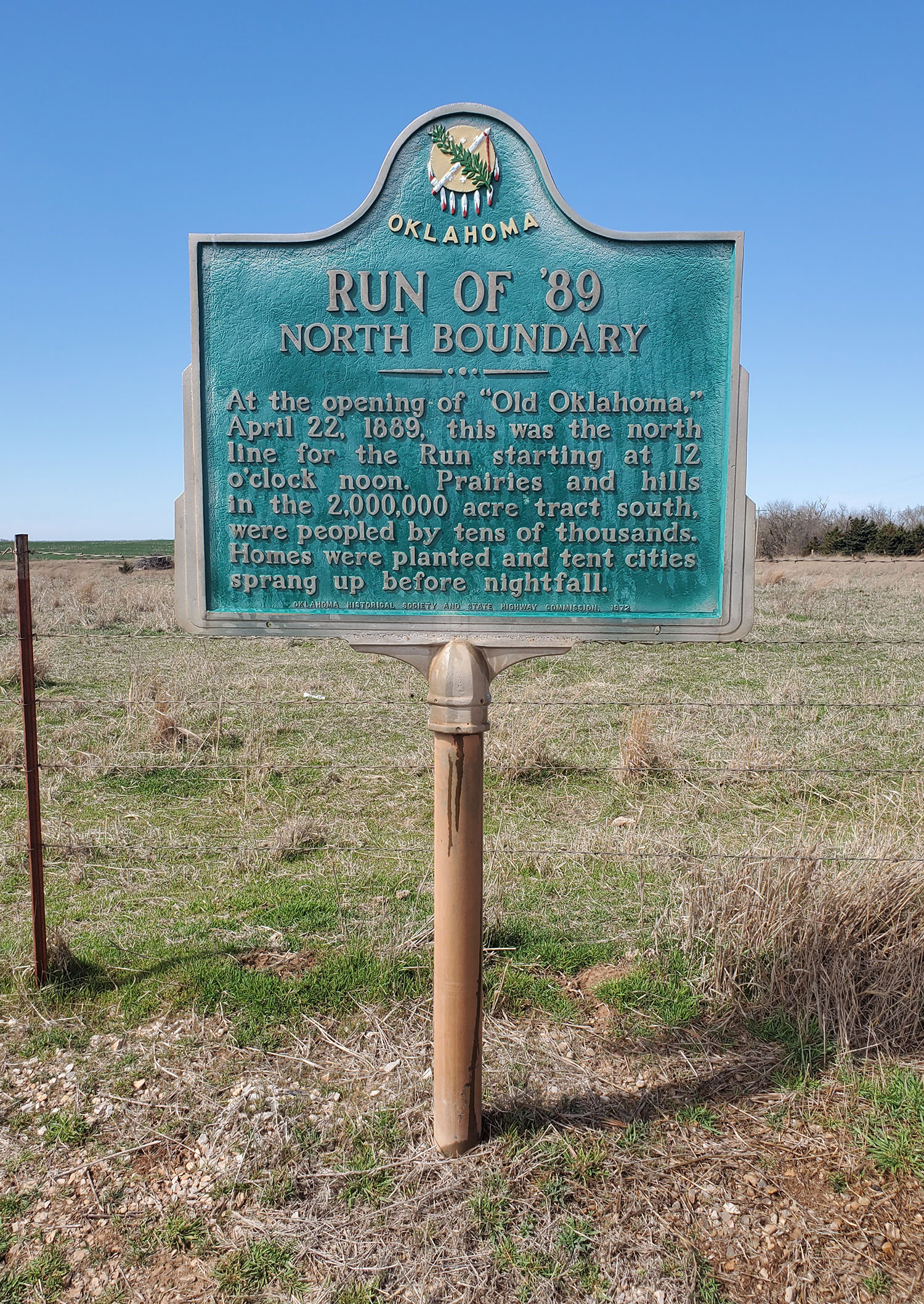
Run of '89 North Border
Logan CountyLocation: on US-77 at Logan-Noble county line, one mile north of Orlando
Coordinates: 36.158890, -97.371849
Sponsored by: Donald W. Reynolds Foundation
Material: Aluminum
Topics: Land Openings, Territorial Period 1861–1907, Settlement Patterns
This east-west line notes the location of the north boundary of the Unassigned Lands which were opened for homesteading on April 22, 1889, comprising the major part of six present-day Oklahoma counties.

Same Old Moses Saloon
Logan CountyLocation: at Second Street and Harrison Avenue in Guthrie
Coordinates: 35.876900, -97.427183
Sponsored by: Donald W. Reynolds Foundation
Material: Aluminum
Topics: Social/Cultural, Territorial Period 1861–1907
This was one of the many open saloons that thrived in Guthrie before prohibition came with statehood. When prohibitionist Carry Nation threatened to wield her bar-breaking hatchet against the saloon, the owner posted a sign on the door, "All nations welcome except Carry.
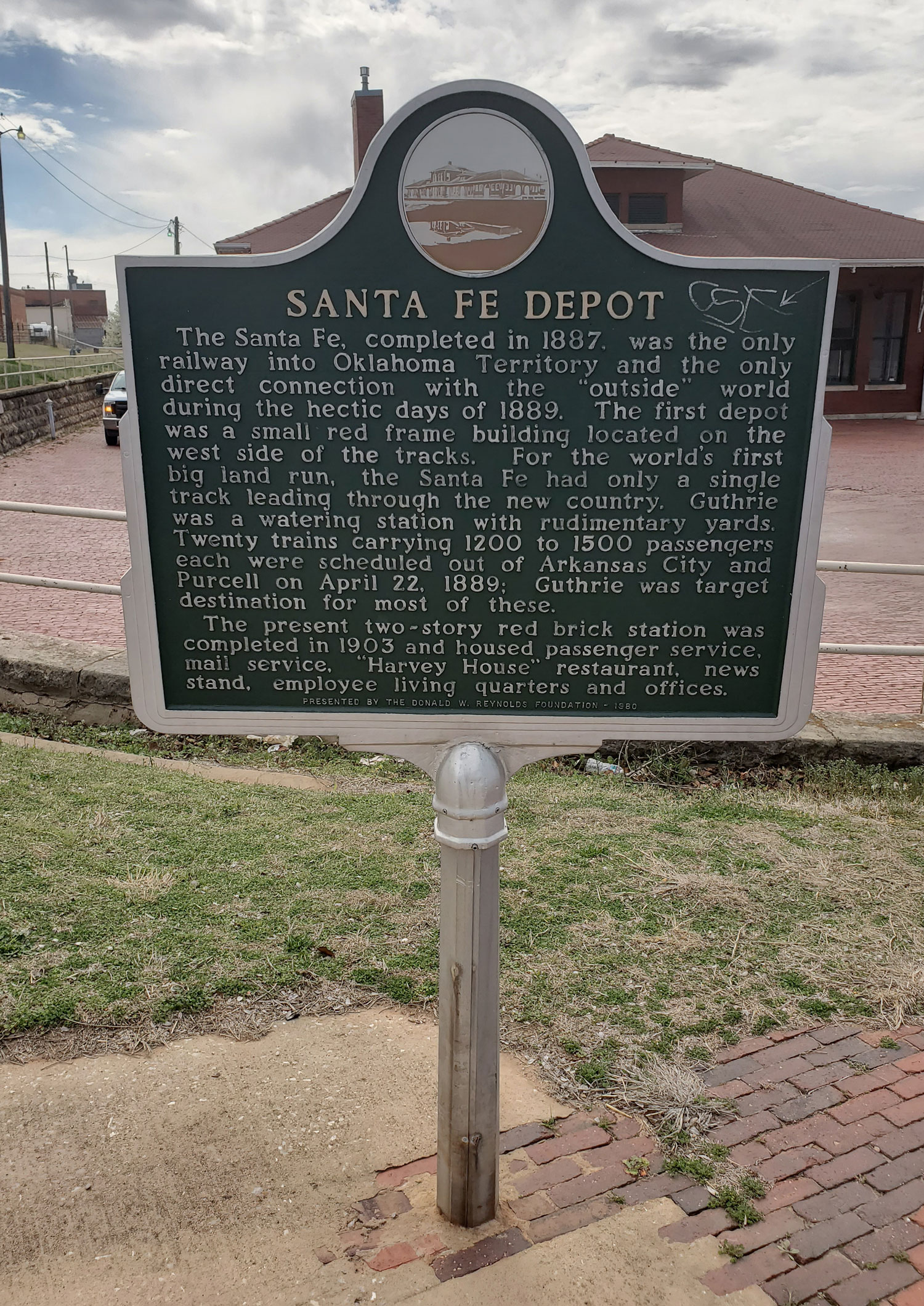
Santa Fe Depot
Logan CountyLocation: at 409 West Oklahoma Avenue in Guthrie
Coordinates: 35.877917, -97.429400
Sponsored by: Donald W. Reynolds Foundation
Material: Aluminum
Topics: Transportation, Territorial Period 1861–1907, Land Openings, Settlement Patterns
The first Santa Fe depot was a small red frame building on the west side of the Santa Fe tracks. The Santa Fe was the only railway into Oklahoma Territory at the time of the 1889 land run. Twenty trains brought up to 1,500 land seekers into the station on the day before the run. The present two-story red brick station was completed in 1903.
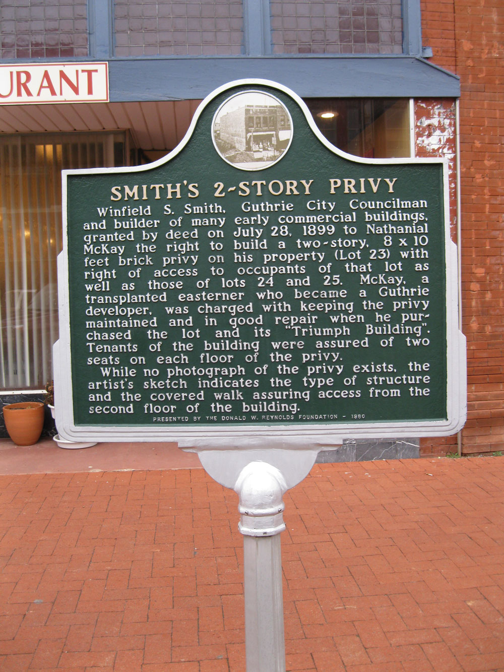
Smith's Two-Story Privy
Logan CountyLocation: at Division Street and Oklahoma Avenue in Guthrie
Coordinates: 35.878150, -97.425683
Sponsored by: Donald W. Reynolds Foundation
Material: Aluminum
Topics: Territorial Period 1861–1907, Social/Cultural, Folklife, Industry/Business
Nathanial McKay was given the right in 1899 to build a two-story brick privy on his property. McKay, who became a Guthrie developer, made the privy accessible from the second floor of adjacent buildings.
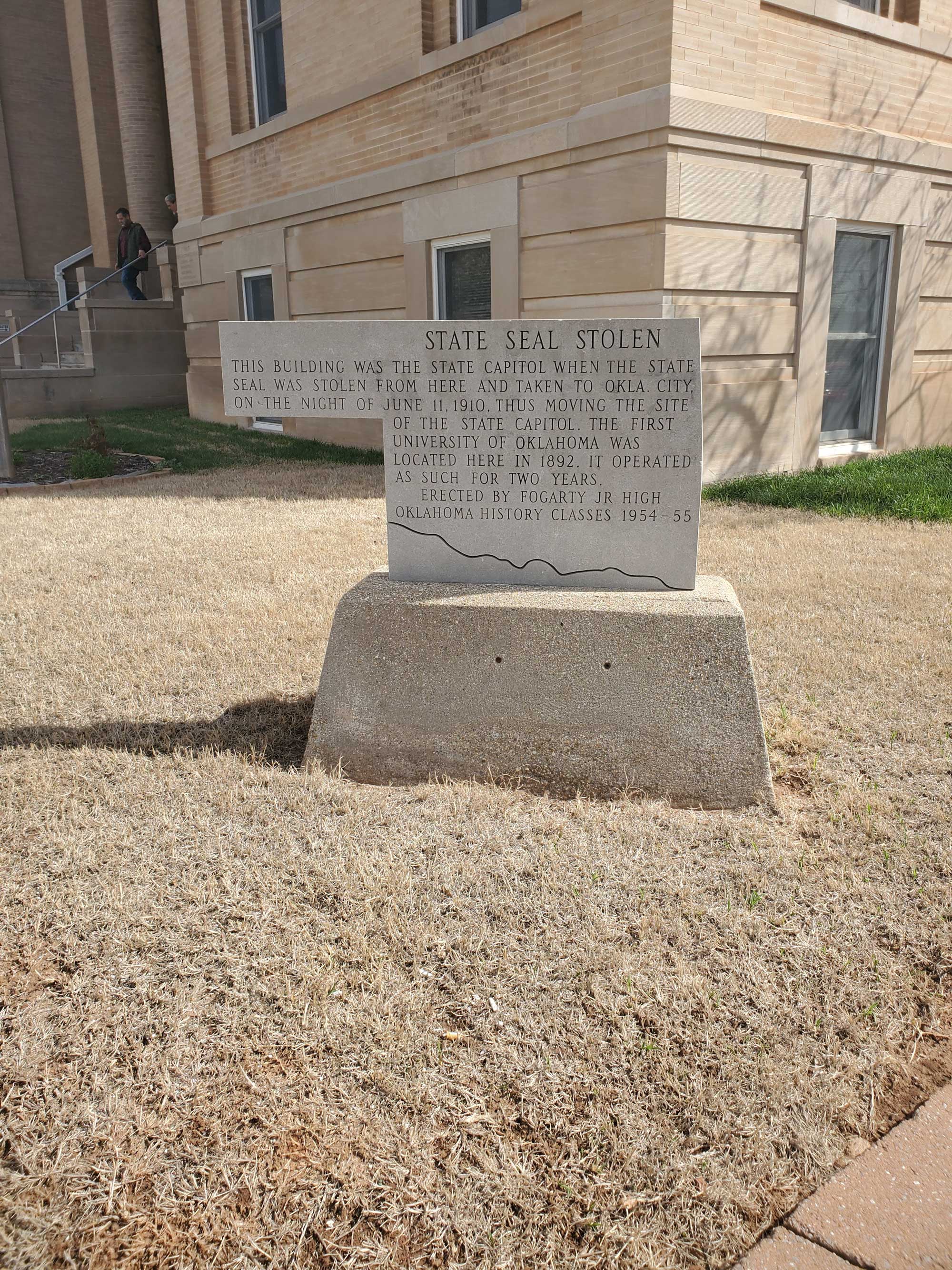
State Seal Stolen
Logan CountyLocation: at East Harrison Avenue and South Broad Street in Guthrie
Coordinates: 35.876867, -97.422650
Sponsored by: Fogarty Jr. High School
Material: Stone
Topics: Government, Early Statehood 1907–1941
This building was the state capitol when the state seal was stolen from here and taken to Oklahoma City, on the night of June 11, 1910, thus moving the site of the state capitol. The first university of Oklahoma was located here in 1892. It operated as such for two years.
US Government Land Office
Logan CountyLocation: on South Second Street in Guthrie
Coordinates: 35.877667, -97.427500
Sponsored by: Donald W. Reynolds Foundation
Material: Aluminum
Topics: Territorial Period 1861–1907, Land Openings, Settlement Patterns, Government
A frame building was erected here before the land run of 1889. Thousands of settlers wanting to claim free land were required to register here and at a similar office in Kingfisher.
Victor Building
Logan CountyLocation: on First Street and Harrison Avenue in Guthrie
Coordinates: 35.877067, -97.426733
Sponsored by: Donald W. Reynolds Foundation
Material: Aluminum
Topics: Industry/Business, Territorial Period 1861–1907, Urban Development, Folklife
When it was completed in 1893, the building was hailed as the finest commercial building in Guthrie. Its basement was connected to other downtown buildings by tunnel. The Joseph Foucart design was restored in the 1980s.
Search for Markers
Search by keyword or browse by county to learn about more than 700 historical markers created to recognize key locations, events, and people in Oklahoma history.
Please note that some markers listed in this database may have been moved, damaged, or are no longer standing.
Browse by County
Alfalfa County
Atoka County
Beaver County
Beckham County
Blaine County
Bryan County
Caddo County
Canadian County
Carter County
Cherokee County
Choctaw County
Cimarron County
Cleveland County
Comanche County
Cotton County
Craig County
Creek County
Custer County
Delaware County
Dewey County
Ellis County
Garfield County
Garvin County
Grady County
Grant County
Greer County
Harmon County
Harper County
Haskell County
Hughes County
Jackson County
Jefferson County
Johnston County
Kay County
Kingfisher County
Kiowa County
Le Flore County
Lincoln County
Logan County
Love County
Marshall County
Mayes County
McClain County
McCurtain County
McIntosh County
Murray County
Muskogee County
Noble County
Okfuskee County
Oklahoma County
Okmulgee County
Osage County
Ottawa County
Pawnee County
Payne County
Pittsburg County
Pontotoc County
Pottawatomie County
Pushmataha County
Roger Mills County
Rogers County
Seminole County
Sequoyah County
Stephens County
Texas County
Tillman County
Tulsa County
Wagoner County
Washington County
Washita County
Woods County
Woodward County
To find out more about the Oklahoma Historical Society Historical Marker Program or how to submit an application, please visit the Historical Marker Program page.
Missing or Damaged Markers
Please use our online form to report missing or damaged historical markers.
Report Missing or Damaged Markers
Contact Us
If you have questions, please contact:
Matthew Pearce
Oklahoma Historical Society
800 Nazih Zuhdi Drive
Oklahoma City, OK 73105
405-522-8659
matthew.pearce@history.ok.gov