
Historical Marker Program
Search Results
Your search returned 18 results.
48 Milepost Old State Line
Le Flore CountyLocation: on OK-1 just west of Arkansas border
Topics: Military; Territorial Period, 1861–1907; Transportation; Westward Expansion, 1803–1861
This site was forty-eight miles from Fort Smith on the military road that ran south to Texas.
Battle of Backbone Mountain
Le Flore CountyLocation: on OK-112, one mile north of OK-120
Topics: American Indians; Military; Territorial Period, 1861–1907
Union forces, led by Major General James G. Blunt, and Confederate troops, commanded by Brigadier General William L. Cabell, skirmished here in September of 1863. On July 27, 1864, a Choctaw battalion under the command of Captain Jackson McCurtain defeated federal troops nearby.
Butterfield Overland Mail Route
Le Flore CountyLocation: on US-271, south bank of Coal Creek, about 1/2 mile south of junction of US-271 and SHY31
Material: Aluminum
Topics: Transportation
Chief Mosholatubbee
Le Flore CountyLocation: in Hall Cemetery south of Cameron on Raymond Adams Road
Material: Granite
Topics: American Indians; GP; Settlement Patterns; Westward Expansion, 1803–1861
Chief Mosholatubbee was one of three Choctaw chiefs who signed early treaties with the United States, including the 1830 Treaty of Dancing Rabbit Creek, which provided for the removal of the Choctaws to Indian Territory. He moved with his people to a new home off the Fort Towson Road, north of Sugar Loaf Mountain, and died August 3, 1838. In his honor, the Choctaw Nation region from the Arkansas River to the Winding Stair Mountains was called Mosholatubbee District.
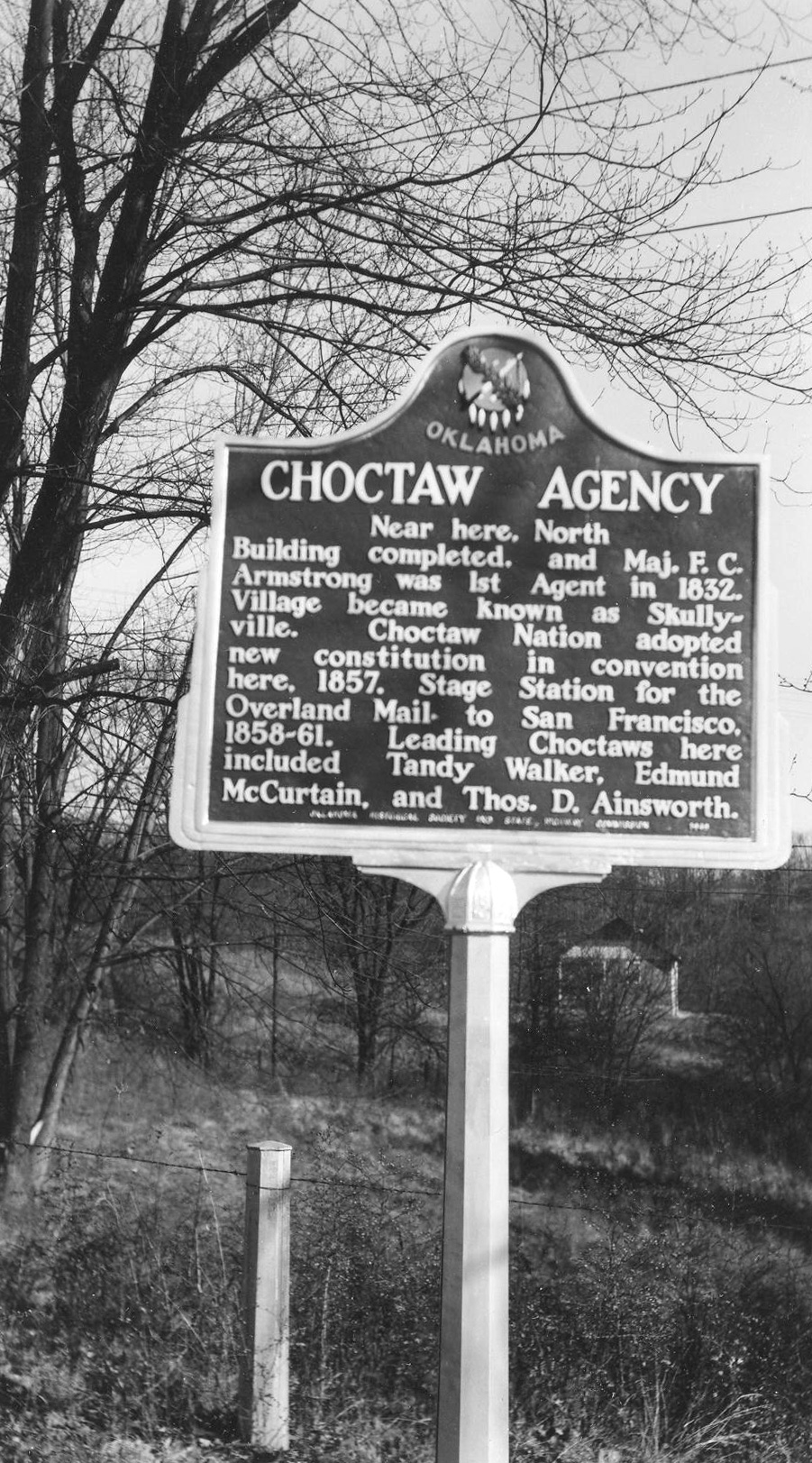
Choctaw Agency
Le Flore CountyLocation: on US-271 east of Spiro
Topics: American Indians; Government; Westward Expansion, 1803–1861
The first building to house Choctaw Indian agents at this location was completed in 1832. The village later was known as Skullyville where a new Choctaw constitution was adopted at a convention in 1857.
First Military Road
Le Flore CountyLocation: on US-271 on Whinding Stair Mountain about eight miles northeast of Talihina
Material: Granite
Topics: Government; Indian and Frontier Trade; Mass Communication; Military; Territorial Period, 1861–1907; Transportation
Here, between 1874 and 1890, supply wagons, a daily stagecoach and the US mail moved over this earliest-known trail from Dodge City, Kansas, to Fort Elliott, Texas. The fort, first known as Cantonment on Sweetwater was established after the Kiowa, Comanche, and Cheyenne attack on Adobe Walls in June of 1874.
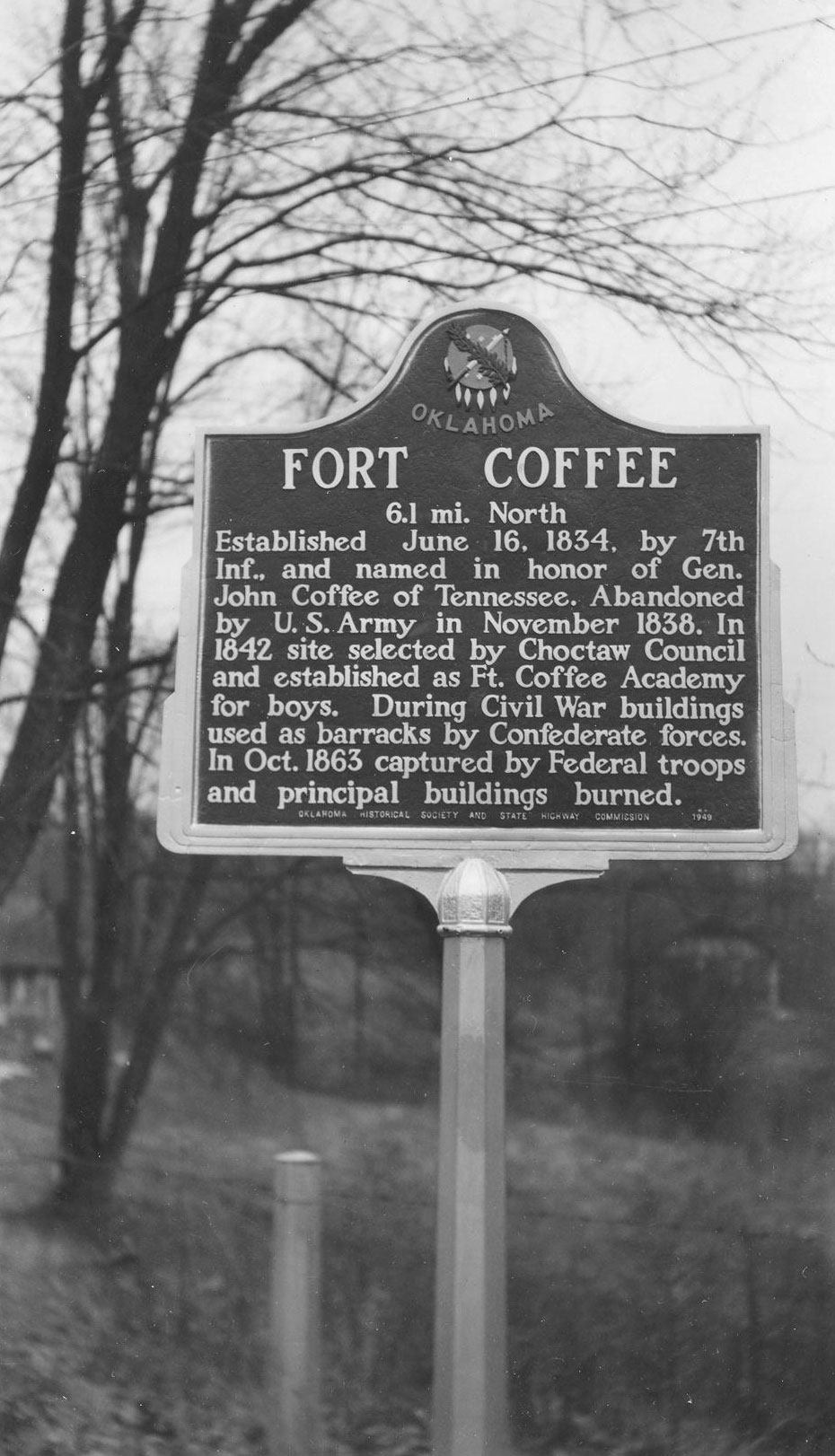
Fort Coffee
Le Flore CountyLocation: on US-271 east of Spiro
Material: Aluminum
Topics: American Indians; Education; Military; Westward Expansion, 1803–1861
Named in honor of General John Coffee of Tennessee, Fort Coffee was established by the 7th Infantry on June 16, 1834, on the southern bank of the Arkansas River. Because of relative peace in the area, the fort was abandoned four years later. In 1842, the Choctaw Council established the Fort Coffee Academy for boys. Confederate forces used the barracks during the Civil War. However, Federal troops overran the post in October of 1863 and burned the main buildings.
Fort Smith/Fort Towson Military Road
Le Flore CountyLocation: on OK-1 east of US-271 junction
Material: Aluminum
Topics: Indian and Frontier Trade; Military; Settlement Patterns; Transportation; Westward Expansion, 1803–1861
Over rugged terrain and through raging streams, Colonel Robert Bean blazed this frontier road which was constructed by Captain John Stuart in 1832. It was used to carry supplies and emigrants from Fort Smith to Fort Towson.
John F. Kennedy Memorial
Le Flore CountyLocation: in Big Cedar
Material: Granite
Topics: Folklife; Government; Social/Cultural
This monument, commemorating the visit of President John F. Kennedy to Big Cedar, was erected under the auspices of the Knights of Columbus, who deeded shaft and land to the Oklahoma Historical Society on October 30, 1966.
Kiamichi Baptist Assembly
Le Flore CountyLocation: three miles north of Talihina (OBHC)
Topics: Industrial Period, 1841–1892; Recreational/Service; Religion/Philosophy
Commemorates the founding of a campground and the Latimer Baptist Association in July 1941.
New Hope Academy
Le Flore CountyMaterial: Granite
Topics: Education
Peter Conser House
Le Flore CountyLocation: on US-59, four miles south and three miles west of Heavener
Topics: American Indians; Family/Household; Government
Peter Conser was a leader of the Choctaw Lighthorsemen and also served as a senator in the Choctaw Legislature. His home is restored to show life in the Choctaw Nation before statehood.
Reverend John Page
Le Flore CountyLocation: on OK-112 south of Pocola
Material: Granite
Topics: American Indians; Government; Recreational/Service; Religion/Philosophy; Transportation
A well-known missionary/circuit minister for the Southern Methodist Church, Page sometimes served as an interpreter in the Choctaw Nation. He was a Choctaw representative to the meeting that resulted in the Reconstruction Treaty of 1866. He was treasurer of the Choctaw Council and a judge on the supreme court of the Choctaw Nation.
Reverend Willis F. Folsom
Le Flore CountyLocation: on OK-112 south of Pocola
Material: Granite
Topics: American Indians; Religion/Philosophy; Westward Expansion, 1803–1861
Reverend Folsom, a Choctaw, was born in Mississippi and removed with his family to Indian Territory in the 1830s. After being educated, he served as an interpreter for white missionaries among the Choctaws and was ordained a deacon in the Methodist Episcopal Church South. He was a great frontier preacher whose influence was widespread among both whites and Choctaws.
Reynolds Castle
Le Flore CountyLocation: at intersection of OK-112 and old OK-112
Topics: Family/Household; Government; Military; Territorial Period, 1861–1907
J.E. Reynolds was a Confederate veteran and pioneer rancher and merchant. His "castle" was built of stone, complete with turrets and two-foot thick walls. Reynolds was a delegate to the Sequoyah Convention, an attempt to create a separate Indian state of the Union.
Skullyville
Le Flore CountyLocation: 3/4 mile north of US-270 on black top road 1.6 miles east of Main Street in Spiro
Material: Granite
Spiro Mounds
Le Flore CountyLocation: at the Spiro Mounds Archaeological Center
Material: Granite
Topics: American Indians; Pre-European Contact, before 1541 AD; Settlement Patterns
Walker’s Station
Le Flore CountyLocation: at site of Old Choctaw Agnecy, about one and a half miles northeast of Spiro
Material: Granite
Topics: Government; Mass Communication; Transportation; Westward Expansion, 1803–1861
Here was located a stage stand of the Butterfield Overland Mail Route, created under an Act of Congress on March 3, 1857. The first mail stage arrived here in September 1858, enroute to San Francisco. Service continued until the outbreak of the War Between the States.
(Page 1 of 1)
Search for Markers
Search by marker name or browse by county or subject to learn about more than 700 historical markers recognizing key locations, events, and people in Oklahoma history.
This database contains markers sponsored by the Oklahoma Historical Society and markers created by other organizations. Please note that some markers listed may have been relocated, damaged, or no longer exist.
Browse by County
Alfalfa County
Atoka County
Beaver County
Beckham County
Blaine County
Bryan County
Caddo County
Canadian County
Carter County
Cherokee County
Choctaw County
Cimarron County
Cleveland County
Comanche County
Cotton County
Craig County
Creek County
Custer County
Delaware County
Dewey County
Ellis County
Garfield County
Garvin County
Grady County
Grant County
Greer County
Harmon County
Harper County
Haskell County
Hughes County
Jackson County
Jefferson County
Johnston County
Kay County
Kingfisher County
Kiowa County
Latimer County
Lincoln County
Logan County
Love County
Major County
Marshall County
Mayes County
McClain County
McCurtain County
McIntosh County
Murray County
Muskogee County
Noble County
Okfuskee County
Oklahoma County
Okmulgee County
Osage County
Ottawa County
Pawnee County
Payne County
Pittsburg County
Pontotoc County
Pottawatomie County
Pushmataha County
Roger Mills County
Rogers County
Seminole County
Sequoyah County
Stephens County
Texas County
Tillman County
Tulsa County
Wagoner County
Washington County
Washita County
Woods County
Woodward County
To find out more about the Oklahoma Historical Society Historical Marker Program or how to submit an application, please visit the Historical Marker Program page.
Missing or Damaged Markers
Please use our online form to report missing or damaged historical markers.
Report Missing or Damaged Markers
Contact Us
If you have questions, please contact:
Matthew Pearce
Oklahoma Historical Society
800 Nazih Zuhdi Drive
Oklahoma City, OK 73105
405-522-8659
matthew.pearce@history.ok.gov