
Home | About OHS | Historical Marker Program
Location: 1.5 miles northwest, then one mile north and seven miles west of the Canadian River bridge on former US Highway 66
Topics: Transportation, Empire Period 1541–1803, Government, Military
At this location on October 1, 1845, a military expedition to the Rocky Mountains under the command of James William Albert paused on its return journey to sketch the buttes appearing to the south. This was the first expedition to make the overland trip with a train of wagons from Bent's Fort, in present-day Colorado, down the Canadian River to Fort Gibson.
Location: on OK-51, 1/2 mile west of Canton
Topics: Military, Religion/Philosophy, Territorial Period 1861–1907, American Indians
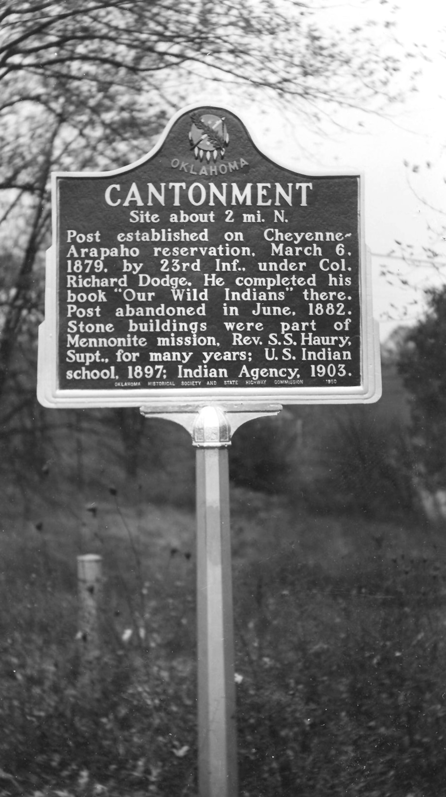
Colonel Richard Dodge established this post in March of 1879 as part of the US Army's attempt to intercept hostile American Indians raiding into Kansas and Nebraska. Major General Philip H. Sheridan directed the construction of the post on the Cheyenne-Arapaho Reservation. Three years later, the stone buildings were abandoned and were eventually used as a Mennonite mission, a federal Indian school, and Indian agency.
Location: on OK-A8 off OK-51 in Roman Nose State Park north of Watonga
Topics: Early Statehood 1907–1941, Social/Cultural, Government, American Indians, Recreational/Service
Men of the Civilian Conservation Corps (CCC) built roads and buildings in the state park during the Great Depression. Opened in 1937, the park is located on land that Cheyenne Chief Henry Roman Nose used as a campground. Chief Roman Nose was a veteran of Plains Indian warfare. He was imprisoned at Fort Marion, Florida, then attended school at Hampton Institute in Virginia and Carlisle Indian School in Pennsylvania.
Location: at Jessie Chisholm's gravesite near Left Hand Springs northeast of Geary
Topics: American Indians, Westward Expansion 1803–1861, Religion/Philosophy
Chief Left Hand was born in the 1840s near Fort Supply. This noted warrior and survivor of the Sand Creek Massacre attended the Medicine Lodge conference in 1867, which resulted in the removal of his people to Indian Territory. He became principal chief of the Southern Arapaho in 1889 and encouraged his tribe to accept the white man's ways. However, he believed the Ghost Dance movement promised a return to the old ways. His allotment included this site, then known as Raven Springs, now Left Hand Springs. In the early 1900s, blindness forced Chief Left Hand to relinquish his position as chief.
Location: on OK-8A in Roman Nose State Park
See CCC-Roman Nose State Park
Location: on US-281, north of Geary
Material: Aluminum
Topics: Indian and Frontier Trade, American Indians, Ranching, Territorial Period 1861–1907
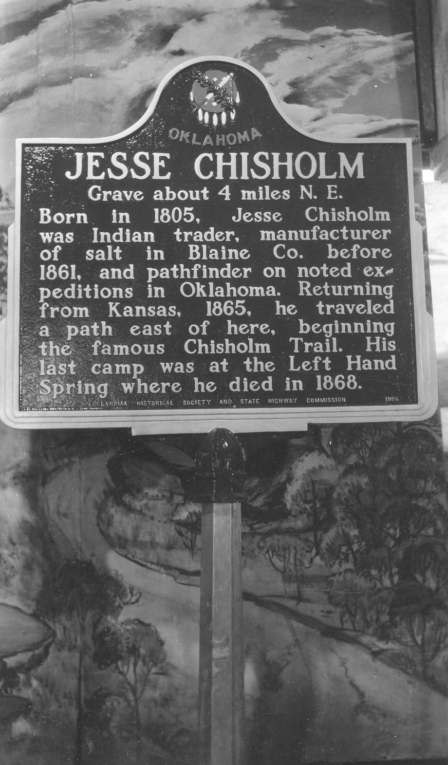
A pioneer merchant, trader, and explorer, Jesse Chisholm established a trail through western Indian Territory before the Civil War. Texas cattlemen used the trail until the late 1880s to move millions of cattle to northern markets. Chisholm died and was buried near this site in March 1868.

Location: at section 32, 15 north, 10 west
Material: Granite
Topics: American Indians, Indian and Frontier Trade, Ranching
Jesse Chisholm, for whom the Chisholm Trail was named, camped at Left Hand Spring in early March 1868. Becoming ill, probably from food poisoning, he died on March 4 and was buried on a nearby knoll.
Location: on OK-51, 1/2 mile west of Canton
Topics: Territorial Period 1861–1907, Government, Military
The road to Fort Cantonment crossed the North Canadian River in this area.
Location: thirteen miles west of Greenfield, on county road and south of the small creek near the north line of SE 1/4 of Sec. 32, T 15 N, R 13 W. Whirlwind Cemetery is near this location
Topics: Religion/Philosophy, Territorial Period 1861–1907, American Indians
A day school for Cheyenne children, named for friendly Chief Whirlwind, opened here at this location in 1897. From 1904 to 1917, it was a well-known mission school under the auspices of the Protestant Episcopal Church.
Le Flore County
Lincoln County
Logan County
Love County
Marshall County
Mayes County
McClain County
McCurtain County
McIntosh County
Murray County
Muskogee County
Noble County
Okfuskee County
Oklahoma County
Okmulgee County
Osage County
Ottawa County
Pawnee County
Payne County
Pittsburg County
Pontotoc County
Pottawatomie County
Pushmataha County
Roger Mills County
Rogers County
Seminole County
Sequoyah County
Stephens County
Texas County
Tillman County
Tulsa County
Wagoner County
Washington County
Washita County
Woods County
Woodward County
Historical Marker Program
Search Results
Your search returned 9 results.
Albert Expedition
Blaine CountyLocation: 1.5 miles northwest, then one mile north and seven miles west of the Canadian River bridge on former US Highway 66
Topics: Transportation, Empire Period 1541–1803, Government, Military
At this location on October 1, 1845, a military expedition to the Rocky Mountains under the command of James William Albert paused on its return journey to sketch the buttes appearing to the south. This was the first expedition to make the overland trip with a train of wagons from Bent's Fort, in present-day Colorado, down the Canadian River to Fort Gibson.
Cantonment
Blaine CountyLocation: on OK-51, 1/2 mile west of Canton
Topics: Military, Religion/Philosophy, Territorial Period 1861–1907, American Indians
Colonel Richard Dodge established this post in March of 1879 as part of the US Army's attempt to intercept hostile American Indians raiding into Kansas and Nebraska. Major General Philip H. Sheridan directed the construction of the post on the Cheyenne-Arapaho Reservation. Three years later, the stone buildings were abandoned and were eventually used as a Mennonite mission, a federal Indian school, and Indian agency.
CCC-Roman Nose State Park
Blaine CountyLocation: on OK-A8 off OK-51 in Roman Nose State Park north of Watonga
Topics: Early Statehood 1907–1941, Social/Cultural, Government, American Indians, Recreational/Service
Men of the Civilian Conservation Corps (CCC) built roads and buildings in the state park during the Great Depression. Opened in 1937, the park is located on land that Cheyenne Chief Henry Roman Nose used as a campground. Chief Roman Nose was a veteran of Plains Indian warfare. He was imprisoned at Fort Marion, Florida, then attended school at Hampton Institute in Virginia and Carlisle Indian School in Pennsylvania.
Chief Left Hand
Blaine CountyLocation: at Jessie Chisholm's gravesite near Left Hand Springs northeast of Geary
Topics: American Indians, Westward Expansion 1803–1861, Religion/Philosophy
Chief Left Hand was born in the 1840s near Fort Supply. This noted warrior and survivor of the Sand Creek Massacre attended the Medicine Lodge conference in 1867, which resulted in the removal of his people to Indian Territory. He became principal chief of the Southern Arapaho in 1889 and encouraged his tribe to accept the white man's ways. However, he believed the Ghost Dance movement promised a return to the old ways. His allotment included this site, then known as Raven Springs, now Left Hand Springs. In the early 1900s, blindness forced Chief Left Hand to relinquish his position as chief.
Chief Roman Nose
Blaine CountyLocation: on OK-8A in Roman Nose State Park
See CCC-Roman Nose State Park
Jesse Chisholm
Blaine CountyLocation: on US-281, north of Geary
Material: Aluminum
Topics: Indian and Frontier Trade, American Indians, Ranching, Territorial Period 1861–1907
A pioneer merchant, trader, and explorer, Jesse Chisholm established a trail through western Indian Territory before the Civil War. Texas cattlemen used the trail until the late 1880s to move millions of cattle to northern markets. Chisholm died and was buried near this site in March 1868.
Jesse Chisholm Grave
Blaine CountyLocation: at section 32, 15 north, 10 west
Material: Granite
Topics: American Indians, Indian and Frontier Trade, Ranching
Jesse Chisholm, for whom the Chisholm Trail was named, camped at Left Hand Spring in early March 1868. Becoming ill, probably from food poisoning, he died on March 4 and was buried on a nearby knoll.
Old Fort Cantonment Crossing
Blaine CountyLocation: on OK-51, 1/2 mile west of Canton
Topics: Territorial Period 1861–1907, Government, Military
The road to Fort Cantonment crossed the North Canadian River in this area.
Whirlwind Mission
Blaine CountyLocation: thirteen miles west of Greenfield, on county road and south of the small creek near the north line of SE 1/4 of Sec. 32, T 15 N, R 13 W. Whirlwind Cemetery is near this location
Topics: Religion/Philosophy, Territorial Period 1861–1907, American Indians
A day school for Cheyenne children, named for friendly Chief Whirlwind, opened here at this location in 1897. From 1904 to 1917, it was a well-known mission school under the auspices of the Protestant Episcopal Church.
(Page 1 of 1)
Search for Markers
Search by keyword or browse by county to learn about more than 700 historical markers created to recognize key locations, events, and people in Oklahoma history.
Please note that some markers listed in this database may have been moved, damaged, or are no longer standing.
Browse by County
Adair County
Alfalfa County
Atoka County
Beaver County
Beckham County
Blaine County
Bryan County
Caddo County
Canadian County
Carter County
Cherokee County
Choctaw County
Cimarron County
Cleveland County
Comanche County
Cotton County
Craig County
Creek County
Custer County
Delaware County
Dewey County
Ellis County
Garfield County
Garvin County
Grady County
Grant County
Greer County
Harmon County
Harper County
Haskell County
Hughes County
Jackson County
Jefferson County
Johnston County
Kay County
Kingfisher County
Kiowa County
Latimer CountyAlfalfa County
Atoka County
Beaver County
Beckham County
Blaine County
Bryan County
Caddo County
Canadian County
Carter County
Cherokee County
Choctaw County
Cimarron County
Cleveland County
Comanche County
Cotton County
Craig County
Creek County
Custer County
Delaware County
Dewey County
Ellis County
Garfield County
Garvin County
Grady County
Grant County
Greer County
Harmon County
Harper County
Haskell County
Hughes County
Jackson County
Jefferson County
Johnston County
Kay County
Kingfisher County
Kiowa County
Le Flore County
Lincoln County
Logan County
Love County
Marshall County
Mayes County
McClain County
McCurtain County
McIntosh County
Murray County
Muskogee County
Noble County
Okfuskee County
Oklahoma County
Okmulgee County
Osage County
Ottawa County
Pawnee County
Payne County
Pittsburg County
Pontotoc County
Pottawatomie County
Pushmataha County
Roger Mills County
Rogers County
Seminole County
Sequoyah County
Stephens County
Texas County
Tillman County
Tulsa County
Wagoner County
Washington County
Washita County
Woods County
Woodward County
Contact Us
If you have questions, please contact:
Matthew Pearce
Oklahoma Historical Society
800 Nazih Zuhdi Drive
Oklahoma City, OK 73105
405-522-8659
matthew.pearce@history.ok.gov