
Home | About OHS | Historical Marker Program
Location: on US-62 in National Hall of Fame for Famous American Indians in Anadarko
Topics: American Indians, Military, Westward Expansion 1803–1861
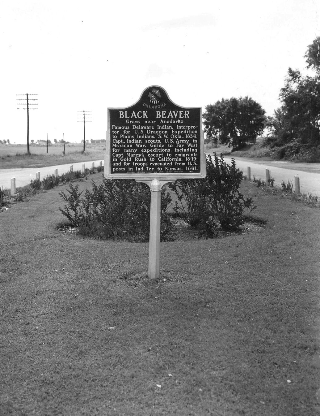
Black Beaver, Delaware Indian frontier scout, served as the interpreter for the US Dragoon Expedition to the Plains Indians in 1834. He was awarded the rank of captain and helped guide expeditions to the Far West, including Captain Randolph Marcy's trip to the goldfields in California in 1849. Black Beaver was buried near his home northwest of Anadarko. In 1975 the Delaware tribe reinterred his body on the Fort Sill Military Reservation.
Location: two miles east of Binger
Sponsored by: Ramona Taylor Rich
Topics: Education, Early Statehood 1907–1941
Britton School was established in 1911 and originally known as Science Hill. Its name was changed to Britton School in honor of a pioneer family. A church located at the same site served as a grade school.
Location: along highway in front of Concho Indian School, Concho
Topics: American Indians, Territorial Period 1861–1907, Education, Transportation
Noted for the purity of its waters which come from adjacent sand dune areas, Caddo Springs, sometimes called Concho Springs, was a favored spot on the Chisholm Trail. Cheyenne and Arapaho people alike shared the springs as did the Arapahoe School, later named Concho Indian School, built in 1870. The springs were named for the earliest known Oklahoma inhabitants, the Caddo Indians.
Location: on US Highway 62, near boundary line of Caddo and Comanche Counties
Topics: American Indians, Military, Government
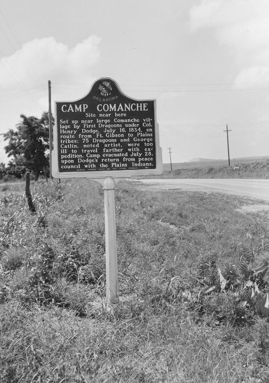
Camp Comanche was set up near a large Comanche village by the First Dragoons under Colonel Henry Dodge on July 16, 1834, while en route from Fort Gibson to Plains tribes. Seventy-five Dragoons and noted artist George Catlin were too ill to travel farther with the expedition. The camp was evacuated July 28, upon Dodge's return from peace councils with the Plains Indians.
Location: on OK-9 in Fort Cobb
Material: Aluminum
Topics: Military, American Indians, Western Expansion 1803–1861, Territorial Period 1861–1907
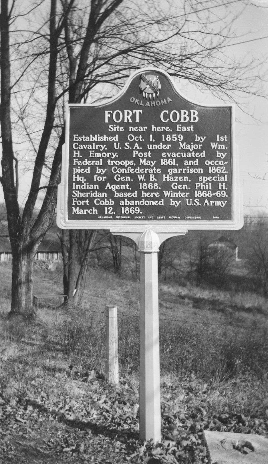
Established October 1, 1859, Fort Cobb was manned by Federal troops to allay fears of raids by Plains Indians on Choctaws, Chickasaws, and white settlers moving West. Four companies of infantry were garrisoned at the fort until it was evacuated in May of 1861. During the Civil War, the fort was occupied by Confederate soldiers. After the Battle of the Washita (1868), Fort Cobb was headquarters of General W. B. Hazen, special Indian agent, General Philip H. Sheridan, and Colonel George Armstrong Custer. The US Army abandoned the post in March of 1869.
Location: on US 281, near entrance to Riverside School north of Anadarko
Material: Aluminum
Topics: American Indians, Education, Territorial Period 1861–1907
Established by Alfred J. Standing on September 23, 1871, east of Fort Cobb on the Washita River, the Riverside Indian School became a highly successful boarding school for Wichita and Caddo children. Fire destroyed the original building in 1878, but the school was rebuilt nearby. It is one of the oldest Indian schools in continuous operation in the nation.
Location: on US-281, one mile south of Hinton
Topics: Westward Expansion 1803–1861, Government, Military, Social/Cultural
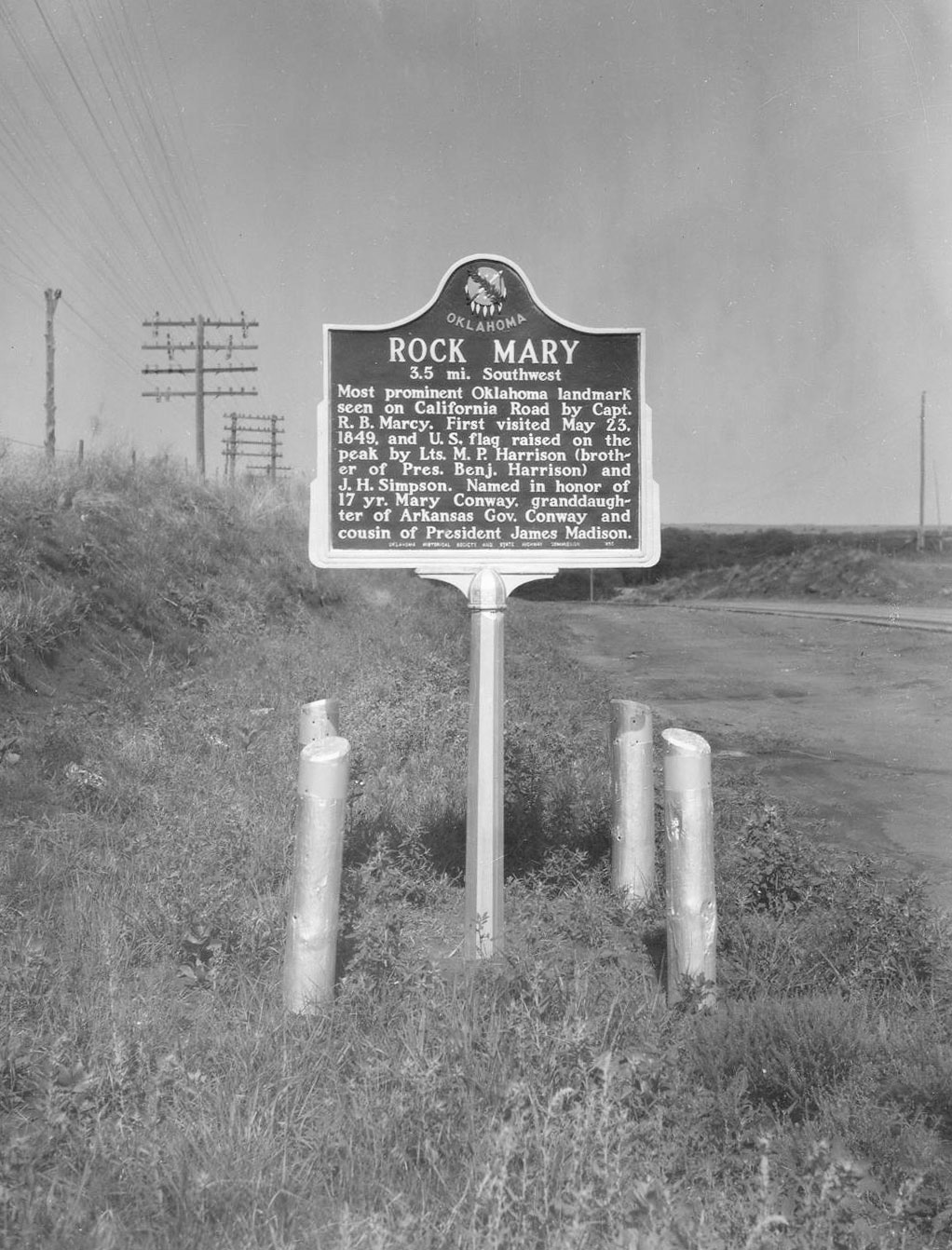
In 1849, Captain Randolph Marcy and his party camped nearby on their way to the gold fields in California. Several of Marcy's junior officers were enamored with a 17-year-old maiden, Mary Conway, a cousin of President James Madison. To seek her favor, the men raced to the crest of the nearby hill. Lieutenant J.H. Simpson planted an American flag and named the hill "Rock Mary" in her honor. They became engaged, but Simpson was killed by an outlaw party before they could marry.
Location: on OK-8, three miles north of Anadarko (OBHC)
Topics: Religion/Philosophy, American Indians, Territorial Period 1861–1907
Rock Springs was the first Baptist church established among the Plains Indians. The church was organized in 1874 by John McIntosh, a Creek Indian who was the first known Baptist missionary to the Plains tribes.
Location: on OK-66 west of junction with US-281
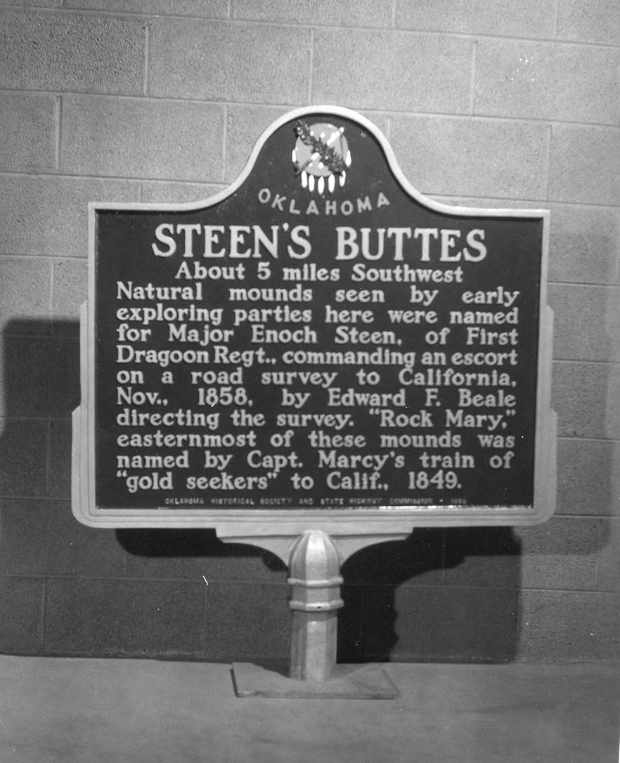
Topics: Military, Government, Westward Expansion 1803–1861
Exploring parties saw these natural mounds and named them for Major Enoch Steen of the First Dragoon Regiment who commanded an escort on a road survey to California in 1858. The easternmost of the mounds is named Rock Mary.
Location: on top of Rock Mary southwest of Hinton
Topics: Military, Government, Social/Cultural, Westward Expansion 1803–1861
Lieutenants M.P. Harrison and J.H. Simpson unfurled the Stars and Stripes on top of Rock Mary on May 23, 1849. See Rock Mary.
Location: three miles west of OK-9 near Fort Cobb
Topics: Early Statehood 1907–1941, Education, Government
From 1923 to 1955, area students were educated in a two-story red brick building. A gray stone gymnasium, built by the Works Progress Administration during the Great Depression, was home to the Washita Eagles but was torn down in 1996.
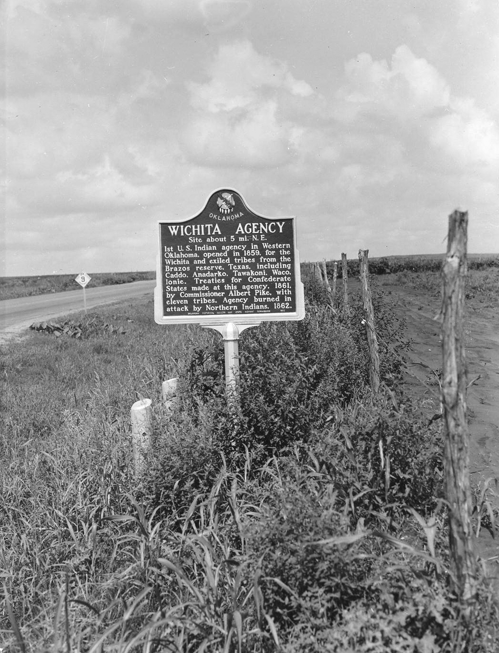
Location: on US-62, eight miles west of Anadarko
Material: Aluminum
Topics: American Indians, Government, Military, Westward Expansion 1803–1861
This first Indian agency opened by the federal government in western Oklahoma began operations in 1859 on the site of an abandoned Kichai village. Agents controlled relations with the Wichitas and exiled tribes from Texas, including Caddo, Anadarko, Tawakoni, Waco, and Ionie. Federal Indian forces attacked the agency on the night of October 23, 1862, before the federal troops all but exterminated the Confederate Tonkawa tribe in a bloody massacre nearby. The attacks closed the work of the agency until after the Civil War when it was moved to Anadarko.
Le Flore County
Lincoln County
Logan County
Love County
Marshall County
Mayes County
McClain County
McCurtain County
McIntosh County
Murray County
Muskogee County
Noble County
Okfuskee County
Oklahoma County
Okmulgee County
Osage County
Ottawa County
Pawnee County
Payne County
Pittsburg County
Pontotoc County
Pottawatomie County
Pushmataha County
Roger Mills County
Rogers County
Seminole County
Sequoyah County
Stephens County
Texas County
Tillman County
Tulsa County
Wagoner County
Washington County
Washita County
Woods County
Woodward County
Historical Marker Program
Search Results
Your search returned 12 results.
Black Beaver
Caddo CountyLocation: on US-62 in National Hall of Fame for Famous American Indians in Anadarko
Topics: American Indians, Military, Westward Expansion 1803–1861
Black Beaver, Delaware Indian frontier scout, served as the interpreter for the US Dragoon Expedition to the Plains Indians in 1834. He was awarded the rank of captain and helped guide expeditions to the Far West, including Captain Randolph Marcy's trip to the goldfields in California in 1849. Black Beaver was buried near his home northwest of Anadarko. In 1975 the Delaware tribe reinterred his body on the Fort Sill Military Reservation.
Britton School
Caddo CountyLocation: two miles east of Binger
Sponsored by: Ramona Taylor Rich
Topics: Education, Early Statehood 1907–1941
Britton School was established in 1911 and originally known as Science Hill. Its name was changed to Britton School in honor of a pioneer family. A church located at the same site served as a grade school.
Caddo Springs
Caddo CountyLocation: along highway in front of Concho Indian School, Concho
Topics: American Indians, Territorial Period 1861–1907, Education, Transportation
Noted for the purity of its waters which come from adjacent sand dune areas, Caddo Springs, sometimes called Concho Springs, was a favored spot on the Chisholm Trail. Cheyenne and Arapaho people alike shared the springs as did the Arapahoe School, later named Concho Indian School, built in 1870. The springs were named for the earliest known Oklahoma inhabitants, the Caddo Indians.
Camp Comanche
Caddo CountyLocation: on US Highway 62, near boundary line of Caddo and Comanche Counties
Topics: American Indians, Military, Government
Camp Comanche was set up near a large Comanche village by the First Dragoons under Colonel Henry Dodge on July 16, 1834, while en route from Fort Gibson to Plains tribes. Seventy-five Dragoons and noted artist George Catlin were too ill to travel farther with the expedition. The camp was evacuated July 28, upon Dodge's return from peace councils with the Plains Indians.
Fort Cobb
Caddo CountyLocation: on OK-9 in Fort Cobb
Material: Aluminum
Topics: Military, American Indians, Western Expansion 1803–1861, Territorial Period 1861–1907
Established October 1, 1859, Fort Cobb was manned by Federal troops to allay fears of raids by Plains Indians on Choctaws, Chickasaws, and white settlers moving West. Four companies of infantry were garrisoned at the fort until it was evacuated in May of 1861. During the Civil War, the fort was occupied by Confederate soldiers. After the Battle of the Washita (1868), Fort Cobb was headquarters of General W. B. Hazen, special Indian agent, General Philip H. Sheridan, and Colonel George Armstrong Custer. The US Army abandoned the post in March of 1869.
Riverside School
Caddo CountyLocation: on US 281, near entrance to Riverside School north of Anadarko
Material: Aluminum
Topics: American Indians, Education, Territorial Period 1861–1907
Established by Alfred J. Standing on September 23, 1871, east of Fort Cobb on the Washita River, the Riverside Indian School became a highly successful boarding school for Wichita and Caddo children. Fire destroyed the original building in 1878, but the school was rebuilt nearby. It is one of the oldest Indian schools in continuous operation in the nation.
Rock Mary
Caddo CountyLocation: on US-281, one mile south of Hinton
Topics: Westward Expansion 1803–1861, Government, Military, Social/Cultural
In 1849, Captain Randolph Marcy and his party camped nearby on their way to the gold fields in California. Several of Marcy's junior officers were enamored with a 17-year-old maiden, Mary Conway, a cousin of President James Madison. To seek her favor, the men raced to the crest of the nearby hill. Lieutenant J.H. Simpson planted an American flag and named the hill "Rock Mary" in her honor. They became engaged, but Simpson was killed by an outlaw party before they could marry.
Rock Springs Baptist Church
Caddo CountyLocation: on OK-8, three miles north of Anadarko (OBHC)
Topics: Religion/Philosophy, American Indians, Territorial Period 1861–1907
Rock Springs was the first Baptist church established among the Plains Indians. The church was organized in 1874 by John McIntosh, a Creek Indian who was the first known Baptist missionary to the Plains tribes.
Steen's Buttes
Caddo CountyLocation: on OK-66 west of junction with US-281
Topics: Military, Government, Westward Expansion 1803–1861
Exploring parties saw these natural mounds and named them for Major Enoch Steen of the First Dragoon Regiment who commanded an escort on a road survey to California in 1858. The easternmost of the mounds is named Rock Mary.
The American Flag
Caddo CountyLocation: on top of Rock Mary southwest of Hinton
Topics: Military, Government, Social/Cultural, Westward Expansion 1803–1861
Lieutenants M.P. Harrison and J.H. Simpson unfurled the Stars and Stripes on top of Rock Mary on May 23, 1849. See Rock Mary.
Washita School
Caddo CountyLocation: three miles west of OK-9 near Fort Cobb
Topics: Early Statehood 1907–1941, Education, Government
From 1923 to 1955, area students were educated in a two-story red brick building. A gray stone gymnasium, built by the Works Progress Administration during the Great Depression, was home to the Washita Eagles but was torn down in 1996.
Wichita Agency
Caddo CountyLocation: on US-62, eight miles west of Anadarko
Material: Aluminum
Topics: American Indians, Government, Military, Westward Expansion 1803–1861
This first Indian agency opened by the federal government in western Oklahoma began operations in 1859 on the site of an abandoned Kichai village. Agents controlled relations with the Wichitas and exiled tribes from Texas, including Caddo, Anadarko, Tawakoni, Waco, and Ionie. Federal Indian forces attacked the agency on the night of October 23, 1862, before the federal troops all but exterminated the Confederate Tonkawa tribe in a bloody massacre nearby. The attacks closed the work of the agency until after the Civil War when it was moved to Anadarko.
(Page 1 of 1)
Search for Markers
Search by keyword or browse by county to learn about more than 700 historical markers created to recognize key locations, events, and people in Oklahoma history.
Please note that some markers listed in this database may have been moved, damaged, or are no longer standing.
Browse by County
Adair County
Alfalfa County
Atoka County
Beaver County
Beckham County
Blaine County
Bryan County
Caddo County
Canadian County
Carter County
Cherokee County
Choctaw County
Cimarron County
Cleveland County
Comanche County
Cotton County
Craig County
Creek County
Custer County
Delaware County
Dewey County
Ellis County
Garfield County
Garvin County
Grady County
Grant County
Greer County
Harmon County
Harper County
Haskell County
Hughes County
Jackson County
Jefferson County
Johnston County
Kay County
Kingfisher County
Kiowa County
Latimer CountyAlfalfa County
Atoka County
Beaver County
Beckham County
Blaine County
Bryan County
Caddo County
Canadian County
Carter County
Cherokee County
Choctaw County
Cimarron County
Cleveland County
Comanche County
Cotton County
Craig County
Creek County
Custer County
Delaware County
Dewey County
Ellis County
Garfield County
Garvin County
Grady County
Grant County
Greer County
Harmon County
Harper County
Haskell County
Hughes County
Jackson County
Jefferson County
Johnston County
Kay County
Kingfisher County
Kiowa County
Le Flore County
Lincoln County
Logan County
Love County
Marshall County
Mayes County
McClain County
McCurtain County
McIntosh County
Murray County
Muskogee County
Noble County
Okfuskee County
Oklahoma County
Okmulgee County
Osage County
Ottawa County
Pawnee County
Payne County
Pittsburg County
Pontotoc County
Pottawatomie County
Pushmataha County
Roger Mills County
Rogers County
Seminole County
Sequoyah County
Stephens County
Texas County
Tillman County
Tulsa County
Wagoner County
Washington County
Washita County
Woods County
Woodward County
Contact Us
If you have questions, please contact:
Matthew Pearce
Oklahoma Historical Society
800 Nazih Zuhdi Drive
Oklahoma City, OK 73105
405-522-8659
matthew.pearce@history.ok.gov