
Home | About OHS | Historical Marker Program
Location: on US-81, eight miles north and one mile east of El Reno
Topics: Social/Cultural, Family/Household
The cemetery was established by the Beecham family to provide burial space for pioneers of the area. Many graves are marked only by crude stones, their inscriptions eroded by a century of exposure to the elements. In 1972, the Beecham Cemetery Association collected funds to provide for perpetual care for the one-acre cemetery.
Location: on Czech Hall Road
Topics: Territorial Period 1861–1907, Ethnic Diversity, Settlement Patterns, Social/Cultural
Bohemian Hall was established in 1899 by early Czech settlers. The original structure was replaced in 1924 by the present building. Bohemian Hall is the focal point of Czech social and musical functions in Oklahoma, including traditional weddings, reunions, and family gatherings. Czech plays have been performed periodically for the last fifty years. The original hand-painted canvas drops for the stage are still in existence.
Location: on US-81, three miles north of El Reno
Material: Granite
Topics: Indian and Frontier Trade, American Indians, Transportation, Ranching
A pioneer merchant, trader, and explorer, Jesse Chisholm, a Cherokee, established a trail through western Indian Territory before the Civil War. Texas cattlemen used the trail until the late 1880s to move millions of cattle to northern markets. The trail ran from Montague County, Texas, to Abilene, Kansas.
Location: on US-81, two miles north of El Reno
Topics: American Indians, Retail, Government, Religion/Philosophy, Transportation, Territorial Period 1861–1907, Mass Communication
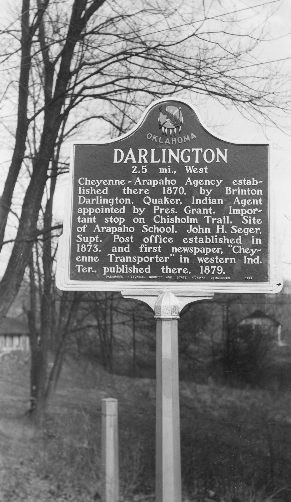
An important stop on the Chisholm Trail, the Cheyenne-Arapaho Agency was established at Darlington in 1870. The settlement is named for Brinton Darlington, a Quaker who was appointed Indian agent by President U. S. Grant. A post office opened in Darlington in 1873 and the first newspaper published in western Indian Territory, the Cheyenne Transporter, was printed in the community in 1879.
Location: on OK-66 at entrance to Fort Reno
Material: Aluminum
Topics: Military, Government, American Indians, Territorial Period 1861–1907, Early Statehood 1907–1941
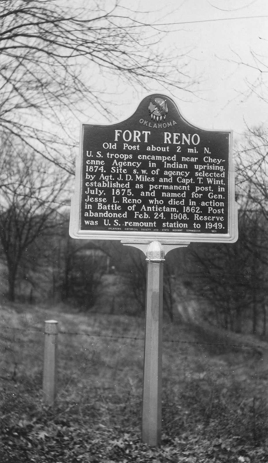
Named for General Jesse L. Reno, who died in action in the Battle of Antietam in 1862, Fort Reno was a prominent outpost among the Cheyenne. US troops camped in the area during an Indian uprising in 1874, and a permanent site for the post was chosen the following year. The post was abandoned as an active military installation in February 1908, but it served as an army remount station until 1949. Many of the original structures still stand.
Location: at entrance to Cemetery Road Parade Ground (DAR)
Sponsored by: Daughters of the American Revolution
See Fort Reno
Location: near Chisholm Trail marker in Yukon
Material: Aluminum
Topics: Ranching, Transportation, Social/Cultural
This memorial commemorating the famous Chisholm Trail was a gift of Oklahoma City philanthropist John E. Kirkpatrick. See Chisholm Trail.
Location: on SH-4 bridge crossing over the South Canadian River between SH-152 and SH-37 (between Mustang and Tuttle).
Coordinates: 35.322898, -97.723439
Topics: American Indians, Government, Military, Territorial Period 1861–1907
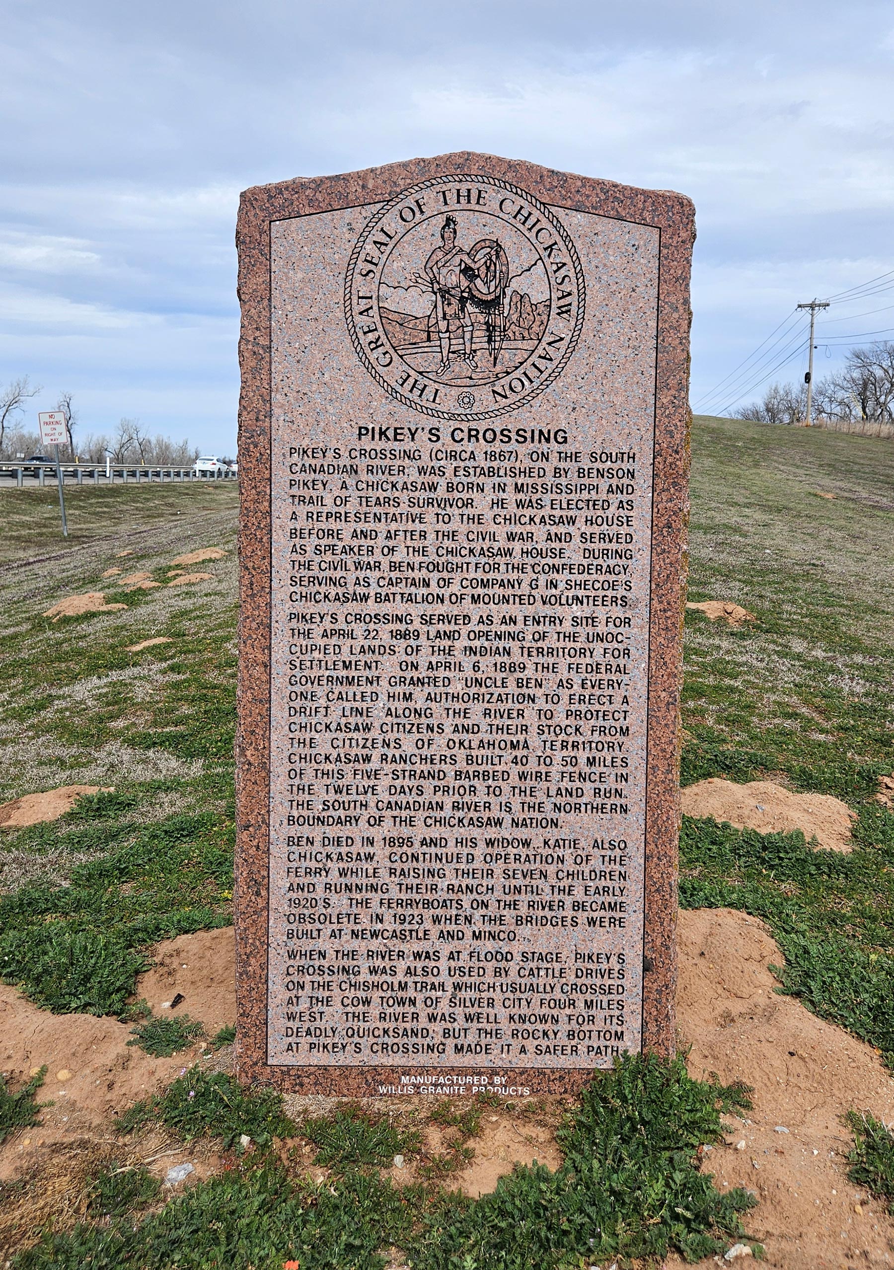
Pikey's Crossing (circa 1867) on the South Canadian River was established by Benson Pikey, a Chickasaw born in Mississippi and Trail of Tears survivor (circa 1837). He was elected as a Representative to the Chickasaw House before and after the Civil War. During the Civil War, Ben fought for the Confederacy, serving as Captain of Company G in Shecoe's Chickasaw Battalion Mounted Volunteers.
Location: on US Highway 66, one mile west of El Reno
Topics: Land Openings, Territorial Period 1861–1907
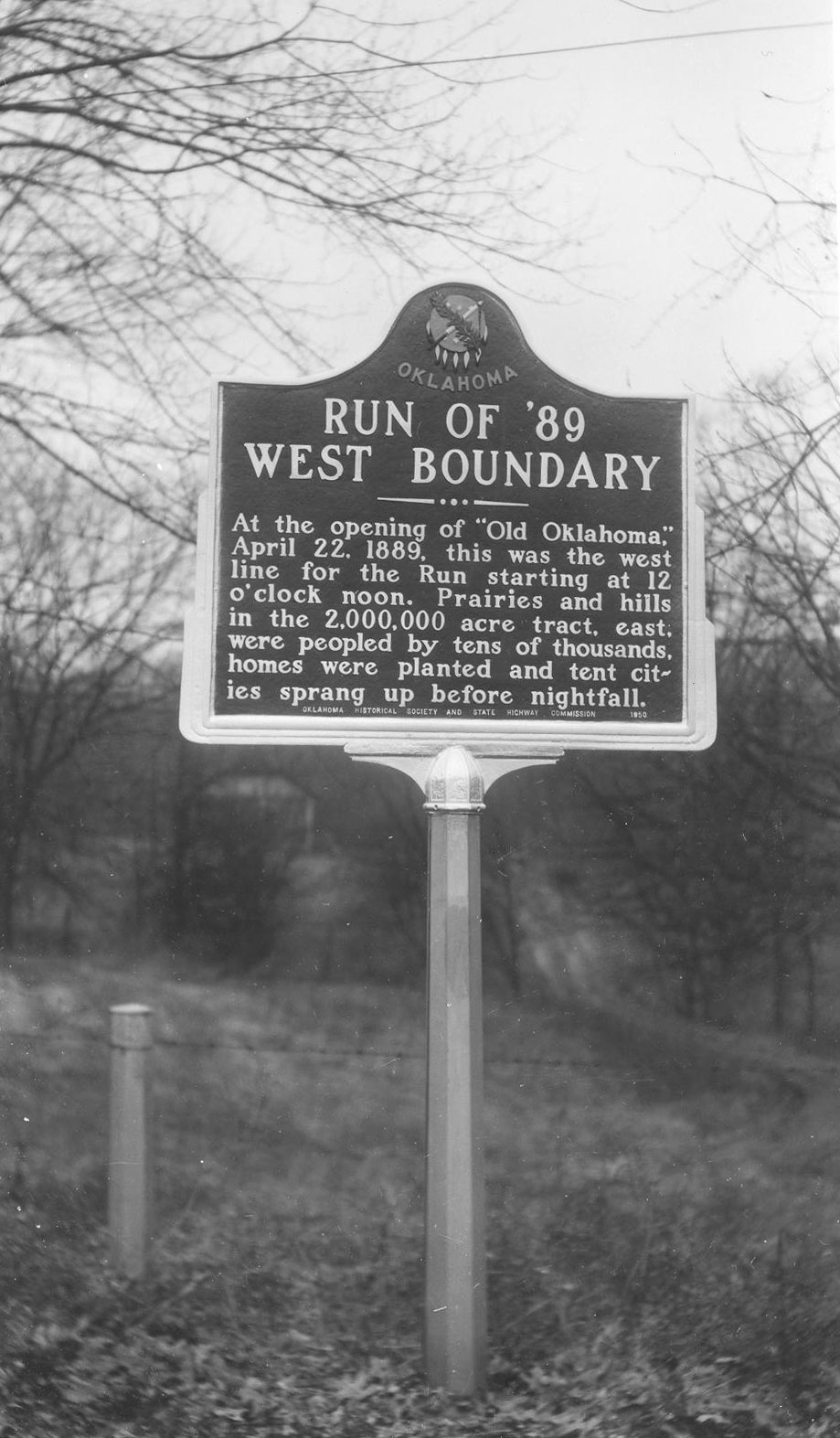
At the opening of the "Old Oklahoma," April 22, 1889, this was the west line for the run starting at noon. Prairies and hills in the 2-million-acre tract, south, were peopled by tens of thousands. Homes were planted and tent cities sprang up before nightfall.
Le Flore County
Lincoln County
Logan County
Love County
Marshall County
Mayes County
McClain County
McCurtain County
McIntosh County
Murray County
Muskogee County
Noble County
Okfuskee County
Oklahoma County
Okmulgee County
Osage County
Ottawa County
Pawnee County
Payne County
Pittsburg County
Pontotoc County
Pottawatomie County
Pushmataha County
Roger Mills County
Rogers County
Seminole County
Sequoyah County
Stephens County
Texas County
Tillman County
Tulsa County
Wagoner County
Washington County
Washita County
Woods County
Woodward County
Historical Marker Program
Search Results
Your search returned 9 results.
Beecham Cemetery
Canadian CountyLocation: on US-81, eight miles north and one mile east of El Reno
Topics: Social/Cultural, Family/Household
The cemetery was established by the Beecham family to provide burial space for pioneers of the area. Many graves are marked only by crude stones, their inscriptions eroded by a century of exposure to the elements. In 1972, the Beecham Cemetery Association collected funds to provide for perpetual care for the one-acre cemetery.
Bohemian Hall
Canadian CountyLocation: on Czech Hall Road
Topics: Territorial Period 1861–1907, Ethnic Diversity, Settlement Patterns, Social/Cultural
Bohemian Hall was established in 1899 by early Czech settlers. The original structure was replaced in 1924 by the present building. Bohemian Hall is the focal point of Czech social and musical functions in Oklahoma, including traditional weddings, reunions, and family gatherings. Czech plays have been performed periodically for the last fifty years. The original hand-painted canvas drops for the stage are still in existence.
Chisholm Trail
Canadian CountyLocation: on US-81, three miles north of El Reno
Material: Granite
Topics: Indian and Frontier Trade, American Indians, Transportation, Ranching
A pioneer merchant, trader, and explorer, Jesse Chisholm, a Cherokee, established a trail through western Indian Territory before the Civil War. Texas cattlemen used the trail until the late 1880s to move millions of cattle to northern markets. The trail ran from Montague County, Texas, to Abilene, Kansas.
Darlington
Canadian CountyLocation: on US-81, two miles north of El Reno
Topics: American Indians, Retail, Government, Religion/Philosophy, Transportation, Territorial Period 1861–1907, Mass Communication
An important stop on the Chisholm Trail, the Cheyenne-Arapaho Agency was established at Darlington in 1870. The settlement is named for Brinton Darlington, a Quaker who was appointed Indian agent by President U. S. Grant. A post office opened in Darlington in 1873 and the first newspaper published in western Indian Territory, the Cheyenne Transporter, was printed in the community in 1879.
Fort Reno
Canadian CountyLocation: on OK-66 at entrance to Fort Reno
Material: Aluminum
Topics: Military, Government, American Indians, Territorial Period 1861–1907, Early Statehood 1907–1941
Named for General Jesse L. Reno, who died in action in the Battle of Antietam in 1862, Fort Reno was a prominent outpost among the Cheyenne. US troops camped in the area during an Indian uprising in 1874, and a permanent site for the post was chosen the following year. The post was abandoned as an active military installation in February 1908, but it served as an army remount station until 1949. Many of the original structures still stand.
Fort Reno
Canadian CountyLocation: at entrance to Cemetery Road Parade Ground (DAR)
Sponsored by: Daughters of the American Revolution
See Fort Reno
Gift of John Kirkpatrick
Canadian CountyLocation: near Chisholm Trail marker in Yukon
Material: Aluminum
Topics: Ranching, Transportation, Social/Cultural
This memorial commemorating the famous Chisholm Trail was a gift of Oklahoma City philanthropist John E. Kirkpatrick. See Chisholm Trail.
Pikey's Crossing
Canadian / Grady CountyLocation: on SH-4 bridge crossing over the South Canadian River between SH-152 and SH-37 (between Mustang and Tuttle).
Coordinates: 35.322898, -97.723439
Topics: American Indians, Government, Military, Territorial Period 1861–1907
Pikey's Crossing (circa 1867) on the South Canadian River was established by Benson Pikey, a Chickasaw born in Mississippi and Trail of Tears survivor (circa 1837). He was elected as a Representative to the Chickasaw House before and after the Civil War. During the Civil War, Ben fought for the Confederacy, serving as Captain of Company G in Shecoe's Chickasaw Battalion Mounted Volunteers.
Run of '89 West Boundary
Canadian CountyLocation: on US Highway 66, one mile west of El Reno
Topics: Land Openings, Territorial Period 1861–1907
At the opening of the "Old Oklahoma," April 22, 1889, this was the west line for the run starting at noon. Prairies and hills in the 2-million-acre tract, south, were peopled by tens of thousands. Homes were planted and tent cities sprang up before nightfall.
(Page 1 of 1)
Search for Markers
Search by keyword or browse by county to learn about more than 600 historical markers created to recognize key locations, events, and people in Oklahoma history.
Please note that some markers listed in this database may have been moved, damaged, or are no longer standing.
Browse by County
Adair County
Alfalfa County
Atoka County
Beaver County
Beckham County
Blaine County
Bryan County
Caddo County
Canadian County
Carter County
Cherokee County
Choctaw County
Cimarron County
Cleveland County
Comanche County
Cotton County
Craig County
Creek County
Custer County
Delaware County
Dewey County
Ellis County
Garfield County
Garvin County
Grady County
Grant County
Greer County
Harmon County
Harper County
Haskell County
Hughes County
Jackson County
Jefferson County
Johnston County
Kay County
Kingfisher County
Kiowa County
Latimer CountyAlfalfa County
Atoka County
Beaver County
Beckham County
Blaine County
Bryan County
Caddo County
Canadian County
Carter County
Cherokee County
Choctaw County
Cimarron County
Cleveland County
Comanche County
Cotton County
Craig County
Creek County
Custer County
Delaware County
Dewey County
Ellis County
Garfield County
Garvin County
Grady County
Grant County
Greer County
Harmon County
Harper County
Haskell County
Hughes County
Jackson County
Jefferson County
Johnston County
Kay County
Kingfisher County
Kiowa County
Le Flore County
Lincoln County
Logan County
Love County
Marshall County
Mayes County
McClain County
McCurtain County
McIntosh County
Murray County
Muskogee County
Noble County
Okfuskee County
Oklahoma County
Okmulgee County
Osage County
Ottawa County
Pawnee County
Payne County
Pittsburg County
Pontotoc County
Pottawatomie County
Pushmataha County
Roger Mills County
Rogers County
Seminole County
Sequoyah County
Stephens County
Texas County
Tillman County
Tulsa County
Wagoner County
Washington County
Washita County
Woods County
Woodward County
Contact Us
If you have questions, please contact:
Matthew Pearce
Oklahoma Historical Society
800 Nazih Zuhdi Drive
Oklahoma City, OK 73105
405-522-8659
matthew.pearce@history.ok.gov