
Home | About OHS | Historical Marker Program
Location: in Brumfield section of Seiling Cemetery
Material: Aluminum
Topics: American Indians, Military, Territorial Period 1861–1907, Government, Westward Expansion 1803–1861
Amos Chapman was a famous civilian American Indian scout employed by the US Army. He was one of only five survivors of the Buffalo Wallow Fight in 1874, an action that earned him the Congressional Medal of Honor. Chapman later married Mary Longneck, the daughter of a Cheyenne chief.
Location: on OK-34, two miles north of Leedy
Part of the road west to California first used by gold seekers in 1849 can be seen at this site.
Location: on US-183 south of intersection with US-60
Coordinates: 36.140223, -98.955791
Sponsored by: Oklahoma Historical Society
Material: Aluminum
Topics: Settlement Patterns, Social/Cultural, Family/Household
Carry Nation and her husband David lived in a log cabin on this site after the opening of the Cheyenne-Arapaho lands in 1892. After moving to Medicine Lodge, Kansas, in 1899, Nation began her famous crusade against liquor, including using a hatchet to smash saloons.
Location: on US-60, five miles west of Vici
Material: Aluminum
Topics: Ranching, Transportation, Territorial Period 1861–1907
From 1874 to 1893, millions of cattle and horses were driven from Texas through what became western Oklahoma over the westernmost of the famous cattle trails. The Dodge City Trail crossed the Red River and Doan's Crossing in Jackson County and continued north to Dodge City, Kansas. A series of markers throughout Oklahoma preserve the memory of the trail.
Location: on US-60, five miles west of Vici
Material: Granite
See Dodge City Trail.
Le Flore County
Lincoln County
Logan County
Love County
Marshall County
Mayes County
McClain County
McCurtain County
McIntosh County
Murray County
Muskogee County
Noble County
Okfuskee County
Oklahoma County
Okmulgee County
Osage County
Ottawa County
Pawnee County
Payne County
Pittsburg County
Pontotoc County
Pottawatomie County
Pushmataha County
Roger Mills County
Rogers County
Seminole County
Sequoyah County
Stephens County
Texas County
Tillman County
Tulsa County
Wagoner County
Washington County
Washita County
Woods County
Woodward County
Historical Marker Program
Search Results
Your search returned 5 results.
Amos Chapman
Dewey CountyLocation: in Brumfield section of Seiling Cemetery
Material: Aluminum
Topics: American Indians, Military, Territorial Period 1861–1907, Government, Westward Expansion 1803–1861
Amos Chapman was a famous civilian American Indian scout employed by the US Army. He was one of only five survivors of the Buffalo Wallow Fight in 1874, an action that earned him the Congressional Medal of Honor. Chapman later married Mary Longneck, the daughter of a Cheyenne chief.
California Road
Dewey CountyLocation: on OK-34, two miles north of Leedy
Part of the road west to California first used by gold seekers in 1849 can be seen at this site.
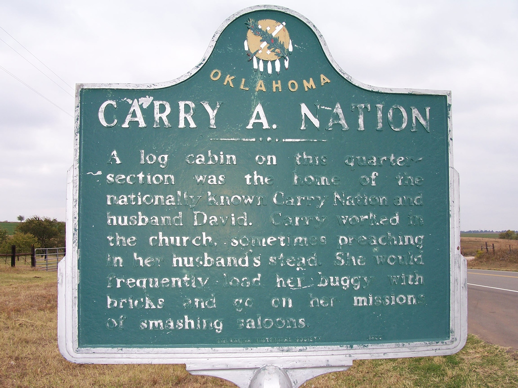
Carry A. Nation
Dewey CountyLocation: on US-183 south of intersection with US-60
Coordinates: 36.140223, -98.955791
Sponsored by: Oklahoma Historical Society
Material: Aluminum
Topics: Settlement Patterns, Social/Cultural, Family/Household
Carry Nation and her husband David lived in a log cabin on this site after the opening of the Cheyenne-Arapaho lands in 1892. After moving to Medicine Lodge, Kansas, in 1899, Nation began her famous crusade against liquor, including using a hatchet to smash saloons.
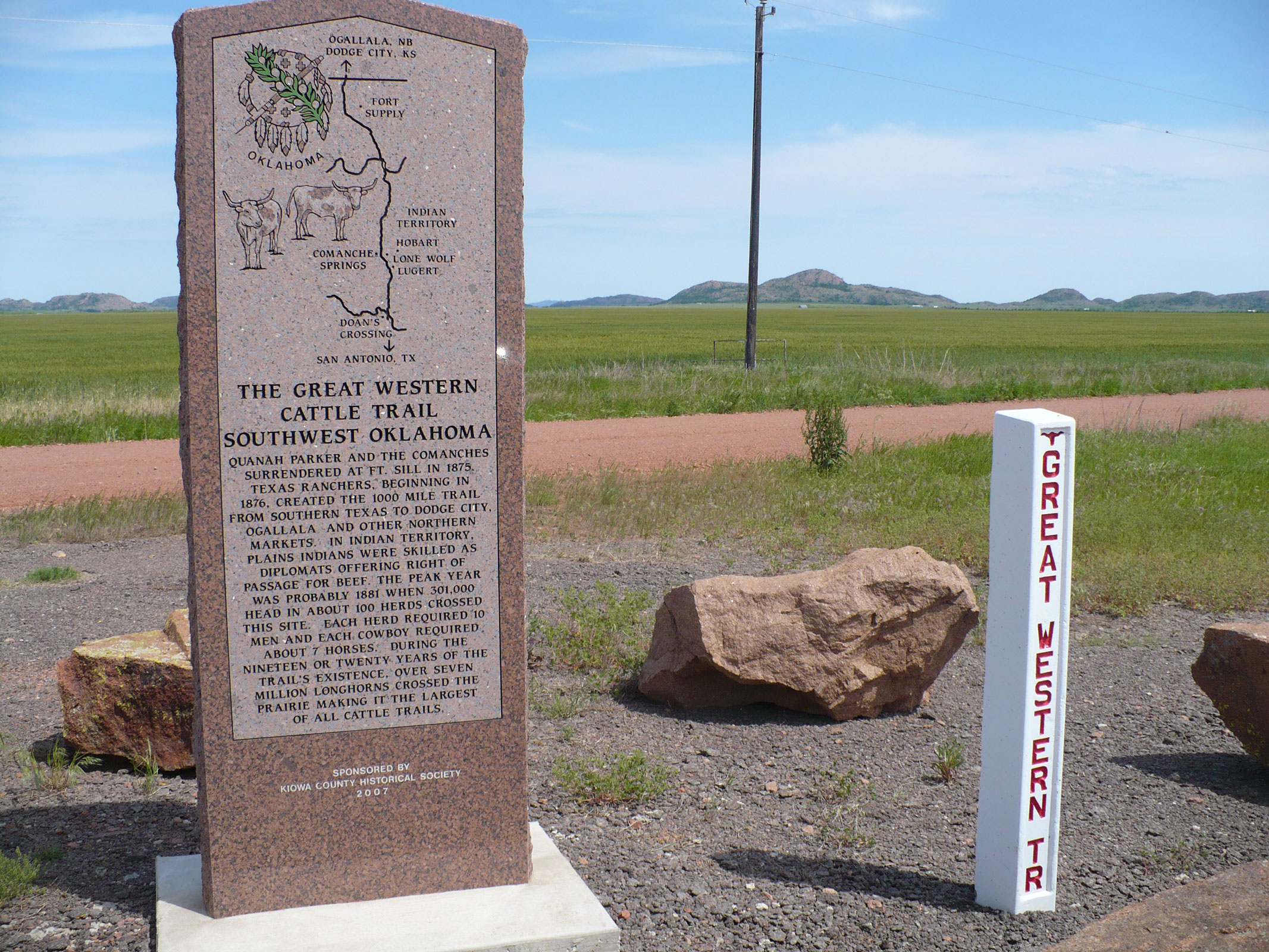
Dodge City Trail
Dewey CountyLocation: on US-60, five miles west of Vici
Material: Aluminum
Topics: Ranching, Transportation, Territorial Period 1861–1907
From 1874 to 1893, millions of cattle and horses were driven from Texas through what became western Oklahoma over the westernmost of the famous cattle trails. The Dodge City Trail crossed the Red River and Doan's Crossing in Jackson County and continued north to Dodge City, Kansas. A series of markers throughout Oklahoma preserve the memory of the trail.
Great Western Trail
Dewey CountyLocation: on US-60, five miles west of Vici
Material: Granite
See Dodge City Trail.
(Page 1 of 1)
Search for Markers
Search by keyword or browse by county to learn about more than 700 historical markers created to recognize key locations, events, and people in Oklahoma history.
Please note that some markers listed in this database may have been moved, damaged, or are no longer standing.
Browse by County
Adair County
Alfalfa County
Atoka County
Beaver County
Beckham County
Blaine County
Bryan County
Caddo County
Canadian County
Carter County
Cherokee County
Choctaw County
Cimarron County
Cleveland County
Comanche County
Cotton County
Craig County
Creek County
Custer County
Delaware County
Dewey County
Ellis County
Garfield County
Garvin County
Grady County
Grant County
Greer County
Harmon County
Harper County
Haskell County
Hughes County
Jackson County
Jefferson County
Johnston County
Kay County
Kingfisher County
Kiowa County
Latimer CountyAlfalfa County
Atoka County
Beaver County
Beckham County
Blaine County
Bryan County
Caddo County
Canadian County
Carter County
Cherokee County
Choctaw County
Cimarron County
Cleveland County
Comanche County
Cotton County
Craig County
Creek County
Custer County
Delaware County
Dewey County
Ellis County
Garfield County
Garvin County
Grady County
Grant County
Greer County
Harmon County
Harper County
Haskell County
Hughes County
Jackson County
Jefferson County
Johnston County
Kay County
Kingfisher County
Kiowa County
Le Flore County
Lincoln County
Logan County
Love County
Marshall County
Mayes County
McClain County
McCurtain County
McIntosh County
Murray County
Muskogee County
Noble County
Okfuskee County
Oklahoma County
Okmulgee County
Osage County
Ottawa County
Pawnee County
Payne County
Pittsburg County
Pontotoc County
Pottawatomie County
Pushmataha County
Roger Mills County
Rogers County
Seminole County
Sequoyah County
Stephens County
Texas County
Tillman County
Tulsa County
Wagoner County
Washington County
Washita County
Woods County
Woodward County
Contact Us
If you have questions, please contact:
Matthew Pearce
Oklahoma Historical Society
800 Nazih Zuhdi Drive
Oklahoma City, OK 73105
405-522-8659
matthew.pearce@history.ok.gov