
Home | About OHS | Historical Marker Program

Location: on US-81, 1 1/2 miles north of Bison
Coordinates: 36.2150336,-97.8872384
Material: Aluminum
Topics: Ranching, Transportation, American Indians, Indian and Frontier Trade, Territorial Period 1861–1907
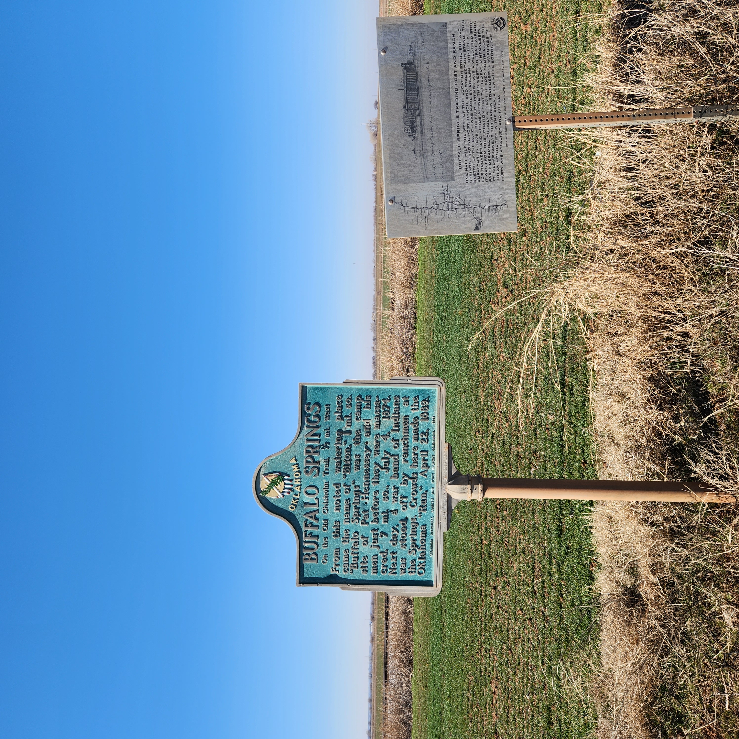
The springs were a favorite rest stop on the Chisholm Trail on long cattle drives from Texas to Kansas. A pioneer merchant, trader, and explorer, Jesse Chisholm, a Cherokee, established the trail through western Indian Territory before the Civil War. Texas cattlemen used the trail until the late 1880s to move millions of cattle to northern markets. The trail ran from Montague County, Texas, to Abilene, Kansas. Buffalo Springs was an important gathering place for settlers making the land run on April 22, 1889.
Location: on US-81 near Garfield-Kingfisher County line south of Bison
Coordinates: 36.164368,-97.8900864
Material: Aluminum
Topics: Land Openings, Territorial Period 1861–1907, Agriculture, Government
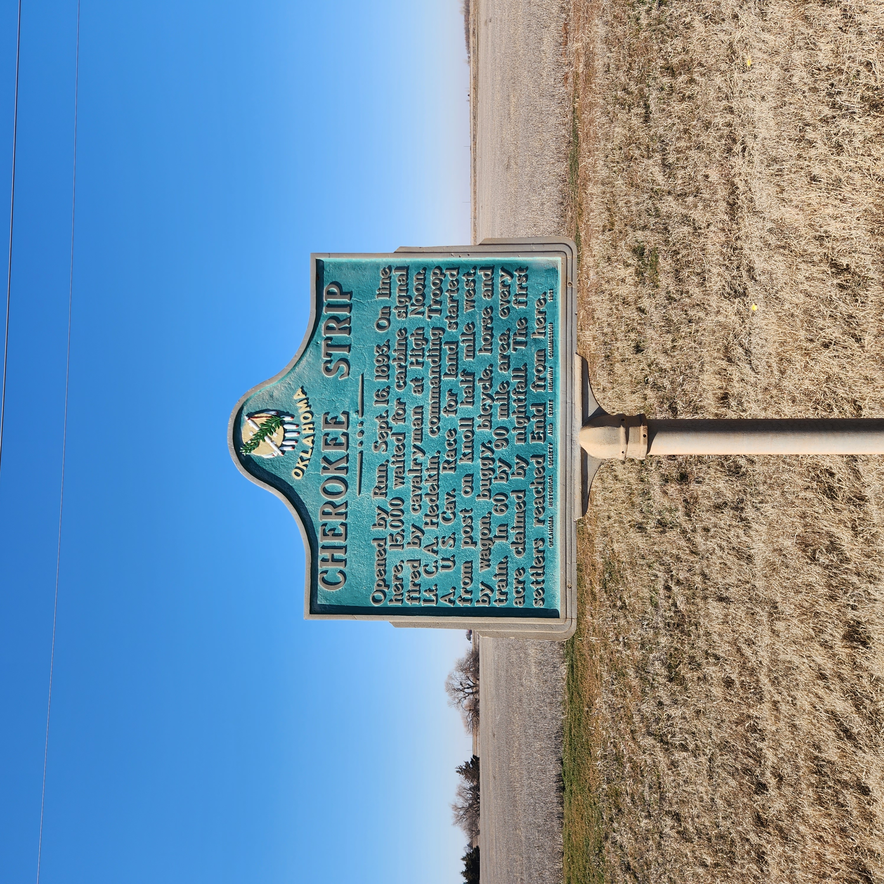
Opened by Run, Sept. 16, 1893. On line here, 15,000 waited for carbine signal fired by cavalryman at High Noon. Lt. C. A. Hedekin, commanding Troop A, U.S. Cav. Race for land started from post on knoll half mile west, by wagon, buggy, bicycle, horse and train. IN 60 by 90 mile area, every acre claimed by nightfall. The first settlers reached Enid from here.
Location: North of Enid on Highway 81 on the east side of the road just north of the Highway 45 intersection
Coordinates: 36.4641915,-97.8731928
Sponsored by: The Jesse Chisholm Trail and Memorial Association
Material: Granite
Topics: American Indians, Indian and Frontier Trade, Transportation, Westward Expansion 1803–1861, Territorial Period 1861–1907
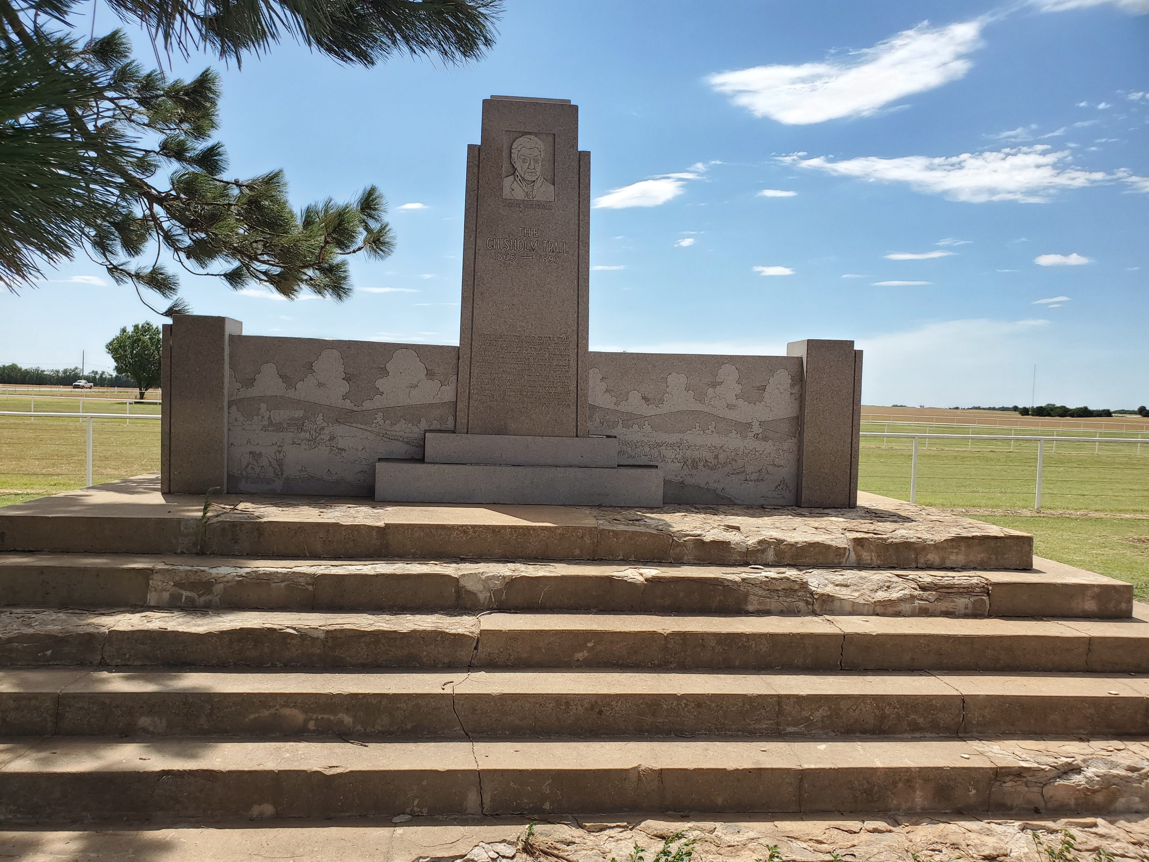
Here passed the old cattle trail, blazed by Jesse Chisolm, which finally stretched for eight hundred miles, from San Antonio, Texas, to Abilene, Kansas, over which cowboys from the pasturelands of the great southwest drove the herds to the railroads. Many tales of the adventure will perhaps remain untold with the passing of those who traveled the trail. To them, this memorial is dedicated, in the year 1945.
Location: 500 S. Independence, Enid, OK 73701
Coordinates: 36.388302,-97.8862934
Material: Aluminum
Topics: Education, Government, Social/Cultural
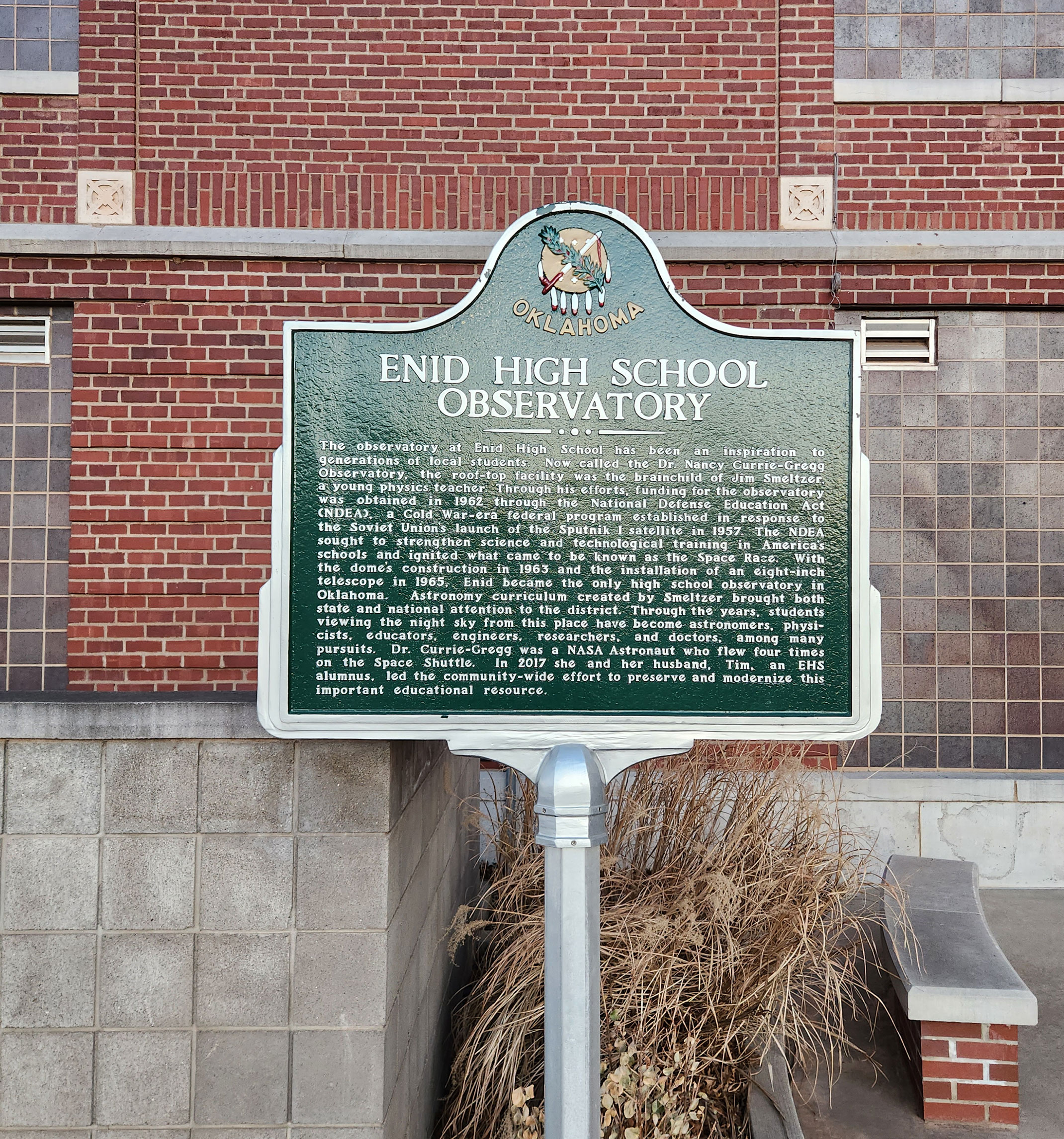
The observatory at Enid High School has been an inspiration to generations of local students. Now called the Dr. Nancy Currie-Gregg Observatory, the roof-top facility was the brainchild of Jim Smeltzer, a young physics teacher. Through his efforts, funding for the observatory was obtained in 1962 through the National Defense Education Act (NDEA), a Cold War-era federal program established in response to the Soviet Union's launch of the Sputnik I satellite in 1957. The NDEA sought to strengthen science and technological training in America's schools and ignited what came to be known as the Space Race. With the dome's construction in 1963 and the installation of an eight-inch telescope in 1965, Enid became the only high school observatory in Oklahoma. Astronomy curriculum created by Smeltzer brought both state and national attention to the district. Through the years, students viewing the night sky from this place have become astronomers, physicists, educators, engineers, researchers, and doctors, among many pursuits. Dr. Currie-Gregg was a NASA Astronaut who flew four times on the Space Shuttle. In 2017 she and her husband, Tim, an EHS alumnus, led the community-wide effort to preserve and modernize this important educational resource.
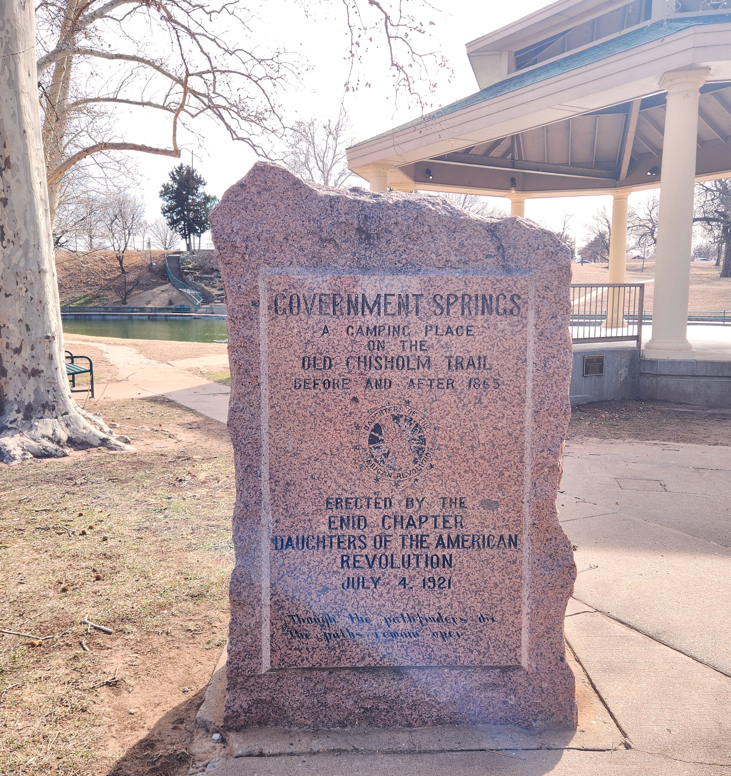
Location: at northwest corner of Government Springs Park in Enid (DAR)
Coordinates: 36.3924789,-97.8717339
Sponsored by: Enid Chapter of the Daughters of the American Revolution
Material: Granite
Topics: Social/Cultural, Transportation, Ranching
Government Springs was a camping place on the Chisholm Trail used originally by Indians and later by all travelers. See Buffalo Springs.
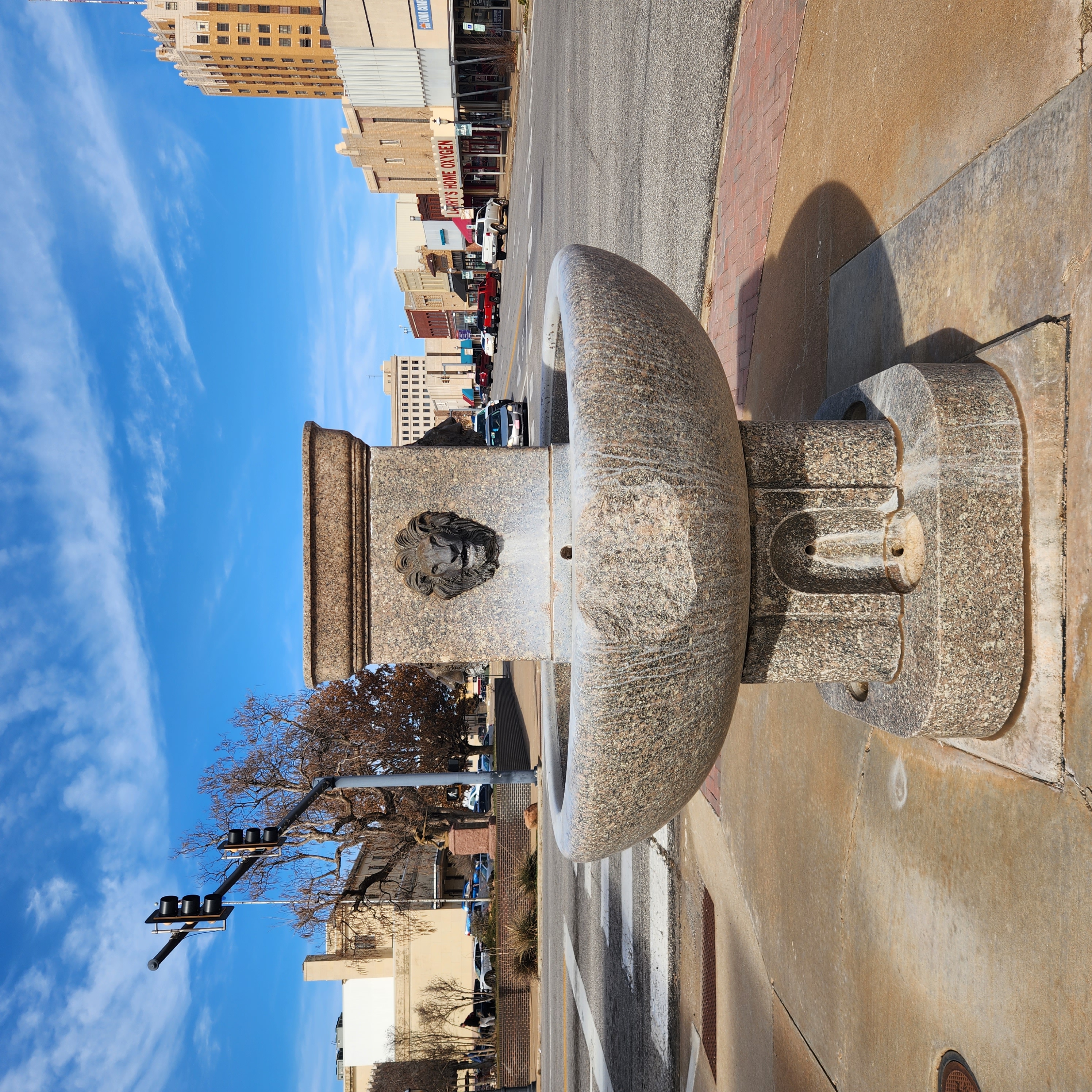
Location: at intersection of East Maine Street and South Grand Avenue in Enid (DAR)
Coordinates: 36.3954215,-97.8785324
Sponsored by: Daughters of the American Revolution
Material: Granite
Topics: Urban Development, Social/Cultural, Recreational/Service
The solid granite trough was originally located in the public square in downtown Enid and was used through the decades as a place to water thirsty horses and later as the center of a children's wading pool.
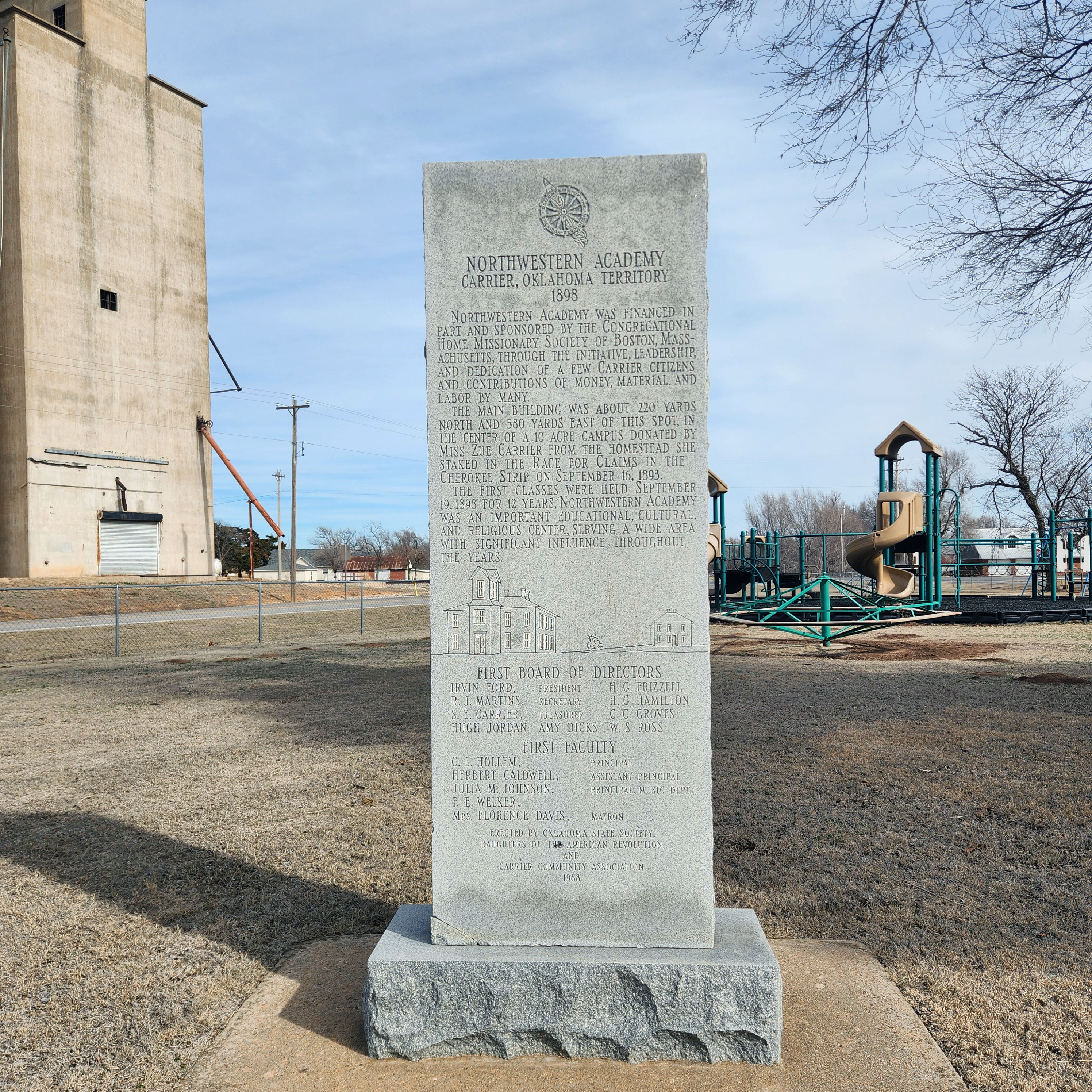
Location: in City Park in Carrier (DAR)
Coordinates: 36.4771082,-98.0223918
Sponsored by: Daughters of the American Revolution and Carrier Community Association, 1968
Material: Granite
Topics: Education, Religion/Philosophy, Territorial Period 1861–1907
Northwestern Academy opened in 1898 under the auspices of the Congregational Home Missionary Society of Boston, Massachusetts. A three-story building was the prominent structure of the school that was an important educational and religious center for twelve years.
Le Flore County
Lincoln County
Logan County
Love County
Marshall County
Mayes County
McClain County
McCurtain County
McIntosh County
Murray County
Muskogee County
Noble County
Okfuskee County
Oklahoma County
Okmulgee County
Osage County
Ottawa County
Pawnee County
Payne County
Pittsburg County
Pontotoc County
Pottawatomie County
Pushmataha County
Roger Mills County
Rogers County
Seminole County
Sequoyah County
Stephens County
Texas County
Tillman County
Tulsa County
Wagoner County
Washington County
Washita County
Woods County
Woodward County
Historical Marker Program
Search Results
Your search returned 7 results.
Buffalo Springs
Garfield CountyLocation: on US-81, 1 1/2 miles north of Bison
Coordinates: 36.2150336,-97.8872384
Material: Aluminum
Topics: Ranching, Transportation, American Indians, Indian and Frontier Trade, Territorial Period 1861–1907
The springs were a favorite rest stop on the Chisholm Trail on long cattle drives from Texas to Kansas. A pioneer merchant, trader, and explorer, Jesse Chisholm, a Cherokee, established the trail through western Indian Territory before the Civil War. Texas cattlemen used the trail until the late 1880s to move millions of cattle to northern markets. The trail ran from Montague County, Texas, to Abilene, Kansas. Buffalo Springs was an important gathering place for settlers making the land run on April 22, 1889.
Cherokee Strip
Garfield CountyLocation: on US-81 near Garfield-Kingfisher County line south of Bison
Coordinates: 36.164368,-97.8900864
Material: Aluminum
Topics: Land Openings, Territorial Period 1861–1907, Agriculture, Government
Opened by Run, Sept. 16, 1893. On line here, 15,000 waited for carbine signal fired by cavalryman at High Noon. Lt. C. A. Hedekin, commanding Troop A, U.S. Cav. Race for land started from post on knoll half mile west, by wagon, buggy, bicycle, horse and train. IN 60 by 90 mile area, every acre claimed by nightfall. The first settlers reached Enid from here.
Chisholm Trail
Garfield CountyLocation: North of Enid on Highway 81 on the east side of the road just north of the Highway 45 intersection
Coordinates: 36.4641915,-97.8731928
Sponsored by: The Jesse Chisholm Trail and Memorial Association
Material: Granite
Topics: American Indians, Indian and Frontier Trade, Transportation, Westward Expansion 1803–1861, Territorial Period 1861–1907
Here passed the old cattle trail, blazed by Jesse Chisolm, which finally stretched for eight hundred miles, from San Antonio, Texas, to Abilene, Kansas, over which cowboys from the pasturelands of the great southwest drove the herds to the railroads. Many tales of the adventure will perhaps remain untold with the passing of those who traveled the trail. To them, this memorial is dedicated, in the year 1945.
Enid High School Observatory
Garfield CountyLocation: 500 S. Independence, Enid, OK 73701
Coordinates: 36.388302,-97.8862934
Material: Aluminum
Topics: Education, Government, Social/Cultural
The observatory at Enid High School has been an inspiration to generations of local students. Now called the Dr. Nancy Currie-Gregg Observatory, the roof-top facility was the brainchild of Jim Smeltzer, a young physics teacher. Through his efforts, funding for the observatory was obtained in 1962 through the National Defense Education Act (NDEA), a Cold War-era federal program established in response to the Soviet Union's launch of the Sputnik I satellite in 1957. The NDEA sought to strengthen science and technological training in America's schools and ignited what came to be known as the Space Race. With the dome's construction in 1963 and the installation of an eight-inch telescope in 1965, Enid became the only high school observatory in Oklahoma. Astronomy curriculum created by Smeltzer brought both state and national attention to the district. Through the years, students viewing the night sky from this place have become astronomers, physicists, educators, engineers, researchers, and doctors, among many pursuits. Dr. Currie-Gregg was a NASA Astronaut who flew four times on the Space Shuttle. In 2017 she and her husband, Tim, an EHS alumnus, led the community-wide effort to preserve and modernize this important educational resource.
Government Springs
Garfield CountyLocation: at northwest corner of Government Springs Park in Enid (DAR)
Coordinates: 36.3924789,-97.8717339
Sponsored by: Enid Chapter of the Daughters of the American Revolution
Material: Granite
Topics: Social/Cultural, Transportation, Ranching
Government Springs was a camping place on the Chisholm Trail used originally by Indians and later by all travelers. See Buffalo Springs.
Horse Watering Trough
Garfield CountyLocation: at intersection of East Maine Street and South Grand Avenue in Enid (DAR)
Coordinates: 36.3954215,-97.8785324
Sponsored by: Daughters of the American Revolution
Material: Granite
Topics: Urban Development, Social/Cultural, Recreational/Service
The solid granite trough was originally located in the public square in downtown Enid and was used through the decades as a place to water thirsty horses and later as the center of a children's wading pool.
Northwestern Academy
Garfield CountyLocation: in City Park in Carrier (DAR)
Coordinates: 36.4771082,-98.0223918
Sponsored by: Daughters of the American Revolution and Carrier Community Association, 1968
Material: Granite
Topics: Education, Religion/Philosophy, Territorial Period 1861–1907
Northwestern Academy opened in 1898 under the auspices of the Congregational Home Missionary Society of Boston, Massachusetts. A three-story building was the prominent structure of the school that was an important educational and religious center for twelve years.
(Page 1 of 1)
Search for Markers
Search by keyword or browse by county to learn about more than 700 historical markers created to recognize key locations, events, and people in Oklahoma history.
Please note that some markers listed in this database may have been moved, damaged, or are no longer standing.
Browse by County
Adair County
Alfalfa County
Atoka County
Beaver County
Beckham County
Blaine County
Bryan County
Caddo County
Canadian County
Carter County
Cherokee County
Choctaw County
Cimarron County
Cleveland County
Comanche County
Cotton County
Craig County
Creek County
Custer County
Delaware County
Dewey County
Ellis County
Garfield County
Garvin County
Grady County
Grant County
Greer County
Harmon County
Harper County
Haskell County
Hughes County
Jackson County
Jefferson County
Johnston County
Kay County
Kingfisher County
Kiowa County
Latimer CountyAlfalfa County
Atoka County
Beaver County
Beckham County
Blaine County
Bryan County
Caddo County
Canadian County
Carter County
Cherokee County
Choctaw County
Cimarron County
Cleveland County
Comanche County
Cotton County
Craig County
Creek County
Custer County
Delaware County
Dewey County
Ellis County
Garfield County
Garvin County
Grady County
Grant County
Greer County
Harmon County
Harper County
Haskell County
Hughes County
Jackson County
Jefferson County
Johnston County
Kay County
Kingfisher County
Kiowa County
Le Flore County
Lincoln County
Logan County
Love County
Marshall County
Mayes County
McClain County
McCurtain County
McIntosh County
Murray County
Muskogee County
Noble County
Okfuskee County
Oklahoma County
Okmulgee County
Osage County
Ottawa County
Pawnee County
Payne County
Pittsburg County
Pontotoc County
Pottawatomie County
Pushmataha County
Roger Mills County
Rogers County
Seminole County
Sequoyah County
Stephens County
Texas County
Tillman County
Tulsa County
Wagoner County
Washington County
Washita County
Woods County
Woodward County
Contact Us
If you have questions, please contact:
Matthew Pearce
Oklahoma Historical Society
800 Nazih Zuhdi Drive
Oklahoma City, OK 73105
405-522-8659
matthew.pearce@history.ok.gov