
Home | About OHS | Historical Marker Program
Location: on OK-3, 1/2 mile east of Ringold
Topics: Government, American Indians, Territorial Period 1861–1907, Folklife, Social/Cultural
The last execution under Choctaw law was carried out here in 1899. According to Choctaw custom, a prisoner sentenced to death was allowed freedom to set family affairs in order from the time of sentencing until he returned to face the firing squad.
Topics: American Indians, Law and Order
Alikchi was established in about 1834 as “Court Town“ or the District Capital of the Oklahoma Falaya (later Apukshunnubbee) District of the Choctaw Nation. On July 13, 1899, Alikchi Court grounds were the scene of the last official execution under Choctaw tribal law. With the Curtis Act of 1906, the court was closed.
Location: at 302 Southeast Adams Street in Idabel
Topics: Family/Household, Government, Early Statehood 1907–1941
The restored 1912 home of Judge T. J. Barnes is now owned by the McCurtain County Historical Society. Barnes was McCurtain County's first county judge. The house contains World War I–era furnishings.
Location: at Beavers Bend State Park near Broken Bow
Material: Granite
Topics: Government, Early Statehood 1907–1941, Environmental/Cultural Ecology, Social/Cultural, Recreation/Service
This unique park was developed between 1935 and 1941 by members of CCC Company 2815, one of many such units organized during the Great Depression by the federal government to provide employment for thousands of young men in conserving and developing the nation's natural resources
Location: at the former Booker T. Washington School campus in Idabel
Coordinates: 33.893863, -94.838091
Sponsored by: Booker T. Washington-Slater-Riverside Alumni Association
Material: Aluminum
Topics: Social/Culture, Ethnic Diversity, Government, Early Statehood 1907–1941, Industrial Period 1941–1982
Booker T. Washington High School began independently in one room of the Masonic Hall. Around 1908, the school moved into an old store. In 1911, it was under the County Superintendent and moved into a two-room building on this site. T.F. Spigner became principal in 1925 and increased the grades steadily through 1931 when three girls graduated 12th grade. The wood building mysteriously burned in l936 and was replaced by the WPA with a stone building costing $21,735. Groundbreaking was held on August 24, 1936, and the building was dedicated on March 24, 1937.
Location: on US Hwy 70 between Broken Bow and Arkansas state line
Topics: Westward Expansion 1803–1861, American Indians, Government, Settlement Patterns, Transportation
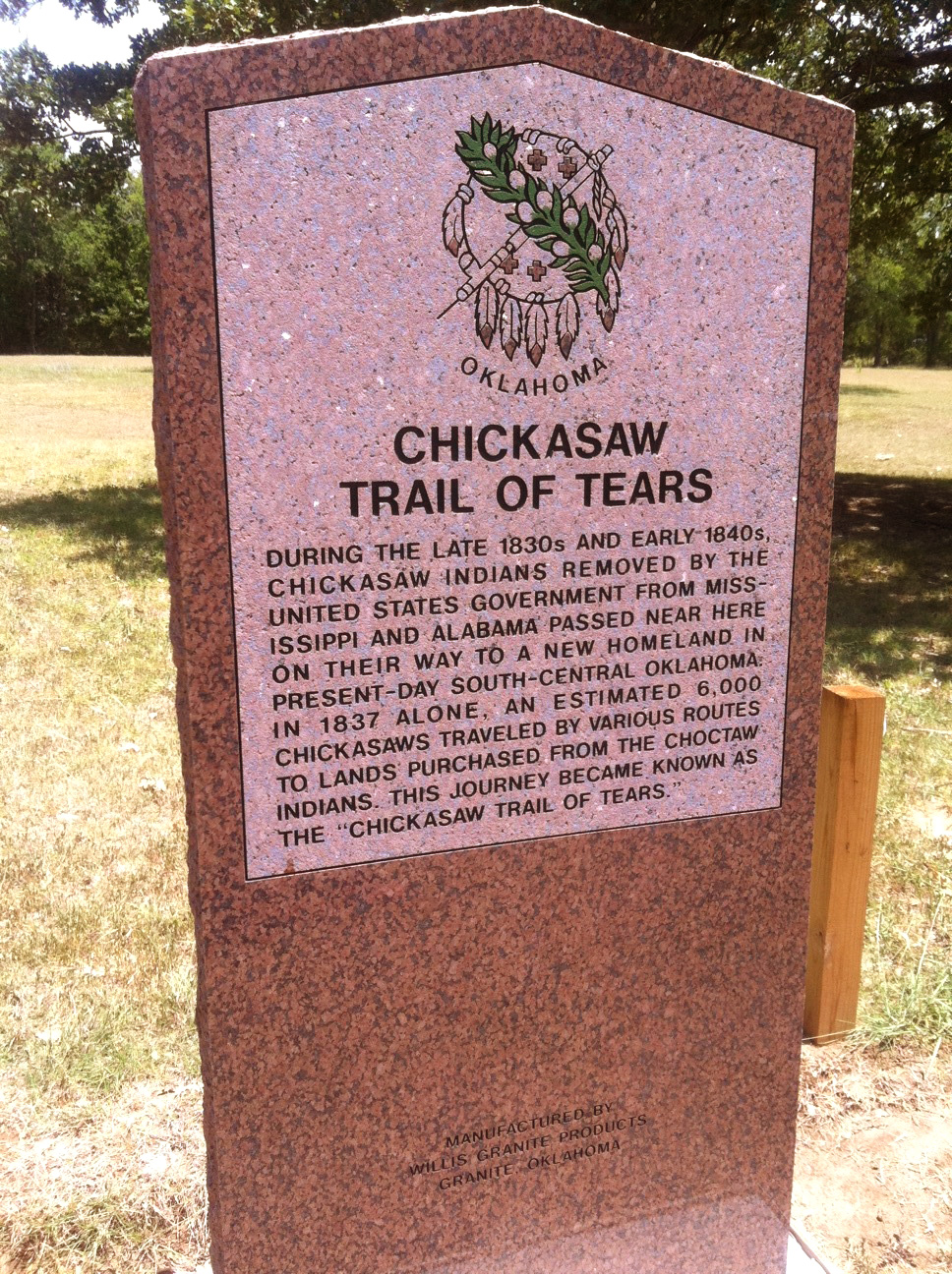
During the late 1830s and early 1840s, Chickasaws removed by the United States government from Mississippi and Alabama passed near here on their way to a new homeland in present-day south-central Oklahoma. In 1937 an estimated 6,000 Chickasaws traveled by various routes to lands purchased from the Choctaws. This journey became known as the Chickasaw Trail of Tears.
Location: in front yard of home five miles south of Smithville
Topics: Government, American Indians, Westward Expansion 1803–1861, Territorial Period 1861–1907, Folklife
This Creek Indian leader opposed allotment of tribal lands and led rebellions against the federal government's abandonment of early treaties with the Indians. He died here in 1909 in the home of Choctaw citizen, Daniel Bob, after being wounded in a gun battle with federal deputy marshals.
Location: in Waterhole Cemetery three miles south of Garvin
Topics: American Indians, Government, Family/Household, Westward Expansion 1803–1861, Social/Cultural
Garvin served as principal chief of the Choctaws from 1879 to his death in 1880.
Location: one mile west of Wheelock Mission on private land
Topics: American Indians
Leflore, chief of the Apuckshunnubbe District of the Choctaw Nation, 1834–1838 and 1842–1850, lived in a home built here under the 1830 Treaty of Dancing Rabbit Creek. He died in 1859 and was buried in a family cemetery nearby.
Location: at a point on US Hwy 70 near Broken Bow, Oklahoma
Topics: Westward Expansion 1803–1861, American Indians, Government, Transportation, Social/Cultural, Settlement Patterns
During the early 1830s, Choctaw Indians removed by the United States government from Mississippi passed near here on their way to new homes in present-day Oklahoma. An estimated 15,000 Choctaws traveled by steamboat, wagon, and on foot to Oklahoma. Approximately one-quarter of the tribe perished from cold, disease, and starvation during the removal journey. This journey became known as the "Choctaw Trails of Tears.
Location: on US-70 on west edge of Valliant
Topics: Arts, Water, Industry/Business, Ethnic Diversity
The water mill was established here in 1818. At the site, the Negro spiritual, "Swing Low Sweet Chariot," was first introduced in writing. The song had been oral tradition until then.
Location: in Eagletown Cemetery north of US-70
Topics: Religion/Philosophy, Education, Westward Expansion 1803–1861, Social/Cultural, Arts
Byington established Stockbridge Mission at Eagletown in 1834 where he produced the Dictionary of the Choctaw Language. The federal government finally published the grammar book in 1915. It is recognized as one of the greatest contributions to the field of American ethnology.
Location: on US-70 west of Mountain Fork River at Eagletown
Material: Granite
Topics: American Indians, Westward Expansion 1803–1861, Government, Religion/Philosophy, Education, Ethnic Diversity, arly Statehood, 1907–1941
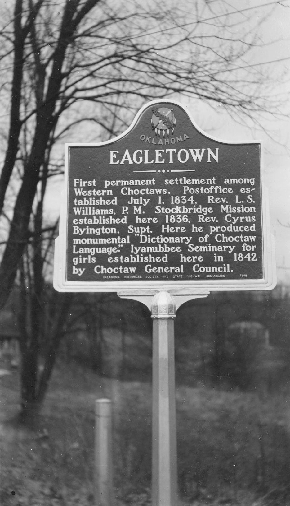
The first permanent settlement among Western Choctaws was west of Mountain Fork River, but the present town was platted east of the river in 1821. Oklahoma's first post office was established here on July 1, 1834.
Location: on US-70, on west edge of Valliant,
Material: Aluminum
Topics: Education
The Presbyterian Board of Missions opened a boarding school for children of freed slaves here in 1886. It was called Oak Hill Industrial School until 1912 when David Elliott contributed funds for the construction of a dormitory in memory of his wife, Alice. Hundreds of African American students were trained here before the school closed in 1936.
Location: on US-70 west of Mountain Fork River
Material: Aluminum
Topics: American Indians, Government, Territorial Period 1861–1907, Religion/Philosophy, Family/Household
Now privately owned, this two-story home belonged to Jefferson Gardner, principal chief of the Choctaws from 1894 to 1896. Well-known Choctaw minister and builder James Dyer constructed the house in 1884 near the site of old Eagletown.
Location: on OK-3, three miles west of the Oklahoma-Arkansas border
Topics: Social/Cultural, American Indians, Agriculture
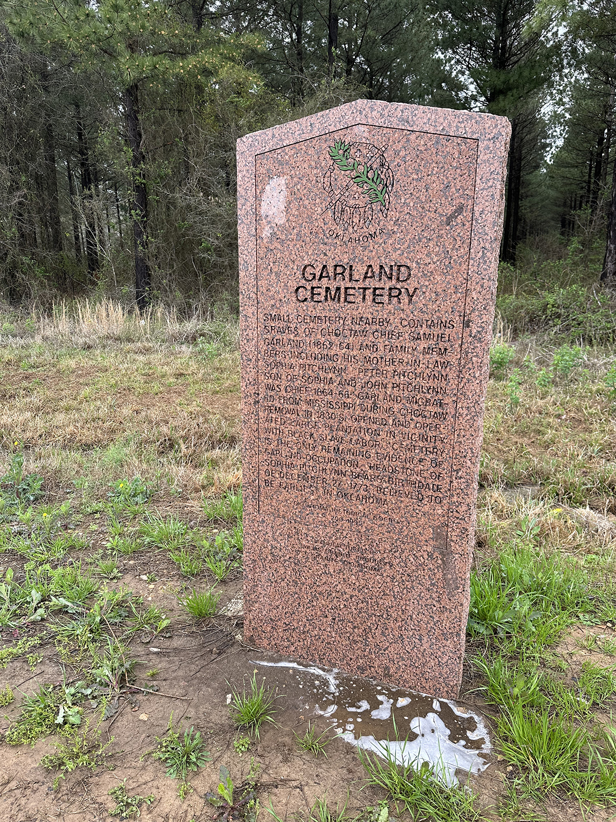
This cemetery was the family burying ground for prominent Choctaws. Chief Samuel Garland, 1864–1866, established a plantation here after arrival over the Trail of Tears in the 1830s. Buried here are Chief Garland and his mother-in-law, Sophia Pitchlynn, the mother of Choctaw Chief Peter Pitchlynn.
Location: on US-259, one mile south of Harris
Topics: Family/Household, Territorial Period 1861–1907, American Indians, Government, Transportation, Agriculture
Judge Henry C. Harris built the house in 1867. He served the Choctaw tribal government in several positions, including supreme judge of the Apukshunnubbe District. He founded Harris Ferry and operated a large plantation along the Red River.
Location: south side Hwy 70, one mile from Arkansas border
Location: on US-259 at Hochatown Union Church and Cemetery
Material: Granite
Topics: Pre-European Contact, before 1541 AD, Westward Expansion 1803–1861, American Indians, Territorial Period 1861-1907, Water, Industrial Period 1892–1941
Prehistoric hunters left spear points along the Mountain Fork River at Hochatown around 6,000 B.C. Caddo Indians occupied the area from 1,000–1791 A.C. The town was named for a Choctaw Indian, Hocha, who arrived on the Trail of Tears in 1833. White settlers moved into the area in 1900. The original town was inundated by waters from Broken Bow Lake in 1968.
Location: on county road, three miles west of Cerro Gordo
Topics: Settlement Patterns
The community was named for a pioneer Doan family member who settled the area before statehood.
Location: near John F. Kennedy Monument, Big Cedar
Topics: Social/Cultural, Government, Folklife
Sponsored by the members of the Poteau Knights of Columbus Council, the nearby granite and bronze marker commemorates the site where John F. Kennedy made his only address as President in Oklahoma.
Location: at 1307 Southeast Adams Street in Idabel
Topics: Family/Household, Early Statehood 1907–1941, Government
This two-story private home was built in 1912 for federal magistrate George A. Spaulding.
Location: on US-70 at chamber of commerce office in Broken Bow
Topics: Transportation, Settlement Patterns, American Indians
Cut from Washington, Arkansas, to Fort Towson in 1831 for removal of Choctaws from Mississippi, the road became known as the "Trail of Tears" after thousands of suffering Indians used it to reach the new land. The road served as a major east-west artery for the Choctaw Nation until early 1900s. Important early settlement along the road were Harris Mill, Eagletown, Lukfata, Wheelock, and Clear Creek. Segments of the road are still visible.
Location: on US-259 near US-70 junction in Idabel
Topics: Government, Westward Expansion 1803–1861, Mass Communication, American Indians, Settlement Patterns
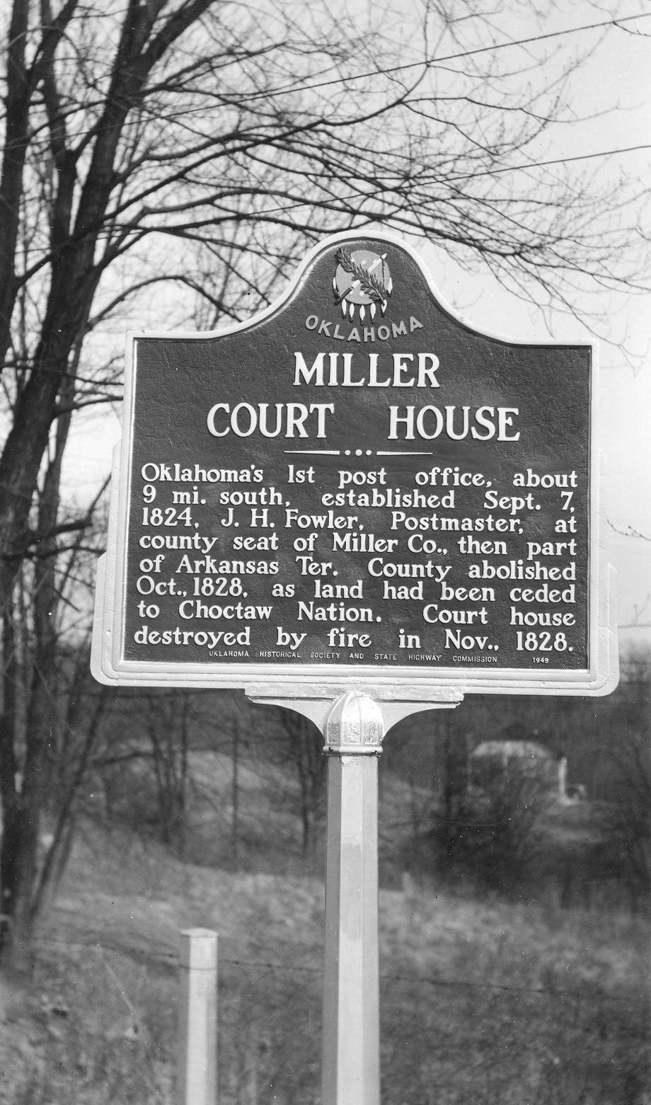
In 1821 this was the site of the first judicial proceedings in what would become Oklahoma. In 1824, a post office was established at an unknown site nearby as county seat of Miller County, Arkansas Territory. White settlers were forced out when the area was ceded to the Choctaws by treaty. The courthouse and post office burned in 1828.
Location: on US-259, one mile south of Harris
Topics: Religion/Philosophy, Indian and Frontier Trade, Westward Expansion 1803–1861
In 1818 Methodist minister Reverend William Stevenson held the first Protestant church service in present-day Oklahoma here at a trading post established three years earlier by George and Alex Wetmore.
Location: on US-259 near US-70 junction in Idabel
Topics: American Indians, Westward Expansion 1803–1861, Settlement Patterns
In the early 1800s a group of Absentee Shawnee Indians occupied a site near the Red River, southwest of present-day Idabel. The Shawnees departed in the 1830s when the area was ceded to the Choctaws.
Location: on US-259, 1/4 mile west of Smithville
Topics: Indian and Frontier Trade, Religion/Philosophy, Westward Expansion 1803–1861, Education, Early Statehood 1907–1941
Town's original name was Hatobi, but it was renamed in 1890. A nearby salt lick inspired the name of Big Lick Presbyterian Church, founded in the 1830s. The Folsom Training School was established here in the early 1920s.
Location: at Wright City
Topics: American Indians, Military
Location: in Garland Cemetery near town of Tom (DAR)
Sponsored by: Daughters of the American Revolution
Topics: Social/Cultural, American Indians, Agriculture
In this cemetery is the grave of Sophia Folsom Pitchlynn, wife of Major John Pitchlynn, who served under General George Washington in the Revolutionary War.
Location: on US-70 west of Mountain Fork River
Topics: American Indians, Government, Social/Cultural
Three prominent Choctaw principal chiefs made Eagletown their home: George Hudson (1860–1862); Peter Pitchlynn (1864–1866); and Jefferson Gardner (1894–1896).
Location: on US-70 between Vallient and Idabel
Material: Granite
Topics: Transportation, Military, Settlement Patterns, Social/Cultural, Folklife
During the early 1800s, present southeastern Oklahoma was a major transportation crossroads. Roads connected Fort Towson in the Choctaw Nation to military installations to the north, south, and west. On the Texas side of the Red River, Jonesboro was a major entry point for thousands headed for Austin's Colony and other settlements in Texas. Along these routes traveled such notable persons as General Zachary Taylor, Sam Houston, David Crockett, Jefferson Davis, and Benjamin Milan.
Location: on county road three miles south of Garvin
Topics: Social/Cultural, American Indians, Territorial Period 1861–1907
One of the first community cemeteries in McCurtain County, Waterhole was used by two Choctaw families in the 1870s, but later became a burial ground for all races. Choctaw Principal Chief Isaac Garvin is buried here.
Location: on US-70, 1 1/2 miles east of Millerton
Material: Aluminum
Topics: Education, American Indians, Social/Cultural, Territorial Period 1861–1907
This boarding school for Choctaw orphan girls was completed in 1884 northeast of the Wheelock Church. Five of the buildings survived and are being restored by the Choctaw Nation.

Location: on US-70, 1 1/2 miles east of Millerton at church site
Material: Aluminum
Topics: Education, Religion/Philosophy, Westward Expansion 1803–1861, American Indians
Wheelock is the oldest church building in Oklahoma. Built by Reverend Alfred Wright in 1846, the stone church is still used. Wright had established the mission among the Choctaws fourteen years earlier. Nearby was the Wheelock Academy, a famous school for Choctaw girls.
Le Flore County
Lincoln County
Logan County
Love County
Marshall County
Mayes County
McClain County
McCurtain County
McIntosh County
Murray County
Muskogee County
Noble County
Okfuskee County
Oklahoma County
Okmulgee County
Osage County
Ottawa County
Pawnee County
Payne County
Pittsburg County
Pontotoc County
Pottawatomie County
Pushmataha County
Roger Mills County
Rogers County
Seminole County
Sequoyah County
Stephens County
Texas County
Tillman County
Tulsa County
Wagoner County
Washington County
Washita County
Woods County
Woodward County
Historical Marker Program
Search Results
Your search returned 34 results.
Alikchi Court Ground
McCurtain CountyLocation: on OK-3, 1/2 mile east of Ringold
Topics: Government, American Indians, Territorial Period 1861–1907, Folklife, Social/Cultural
The last execution under Choctaw law was carried out here in 1899. According to Choctaw custom, a prisoner sentenced to death was allowed freedom to set family affairs in order from the time of sentencing until he returned to face the firing squad.
Alikchi Springs
McCurtain CountyTopics: American Indians, Law and Order
Alikchi was established in about 1834 as “Court Town“ or the District Capital of the Oklahoma Falaya (later Apukshunnubbee) District of the Choctaw Nation. On July 13, 1899, Alikchi Court grounds were the scene of the last official execution under Choctaw tribal law. With the Curtis Act of 1906, the court was closed.
Barnes-Stevenson House
McCurtain CountyLocation: at 302 Southeast Adams Street in Idabel
Topics: Family/Household, Government, Early Statehood 1907–1941
The restored 1912 home of Judge T. J. Barnes is now owned by the McCurtain County Historical Society. Barnes was McCurtain County's first county judge. The house contains World War I–era furnishings.
Beaver's Bend
McCurtain CountyLocation: at Beavers Bend State Park near Broken Bow
Material: Granite
Topics: Government, Early Statehood 1907–1941, Environmental/Cultural Ecology, Social/Cultural, Recreation/Service
This unique park was developed between 1935 and 1941 by members of CCC Company 2815, one of many such units organized during the Great Depression by the federal government to provide employment for thousands of young men in conserving and developing the nation's natural resources
Booker T. Washington High School
McCurtain CountyLocation: at the former Booker T. Washington School campus in Idabel
Coordinates: 33.893863, -94.838091
Sponsored by: Booker T. Washington-Slater-Riverside Alumni Association
Material: Aluminum
Topics: Social/Culture, Ethnic Diversity, Government, Early Statehood 1907–1941, Industrial Period 1941–1982
Booker T. Washington High School began independently in one room of the Masonic Hall. Around 1908, the school moved into an old store. In 1911, it was under the County Superintendent and moved into a two-room building on this site. T.F. Spigner became principal in 1925 and increased the grades steadily through 1931 when three girls graduated 12th grade. The wood building mysteriously burned in l936 and was replaced by the WPA with a stone building costing $21,735. Groundbreaking was held on August 24, 1936, and the building was dedicated on March 24, 1937.
Chickasaw Trail of Tears
McCurtain CountyLocation: on US Hwy 70 between Broken Bow and Arkansas state line
Topics: Westward Expansion 1803–1861, American Indians, Government, Settlement Patterns, Transportation
During the late 1830s and early 1840s, Chickasaws removed by the United States government from Mississippi and Alabama passed near here on their way to a new homeland in present-day south-central Oklahoma. In 1937 an estimated 6,000 Chickasaws traveled by various routes to lands purchased from the Choctaws. This journey became known as the Chickasaw Trail of Tears.
Chitto Harjo, Creek Patriot
McCurtain CountyLocation: in front yard of home five miles south of Smithville
Topics: Government, American Indians, Westward Expansion 1803–1861, Territorial Period 1861–1907, Folklife
This Creek Indian leader opposed allotment of tribal lands and led rebellions against the federal government's abandonment of early treaties with the Indians. He died here in 1909 in the home of Choctaw citizen, Daniel Bob, after being wounded in a gun battle with federal deputy marshals.
Choctaw Chief Isaac Garvin
McCurtain CountyLocation: in Waterhole Cemetery three miles south of Garvin
Topics: American Indians, Government, Family/Household, Westward Expansion 1803–1861, Social/Cultural
Garvin served as principal chief of the Choctaws from 1879 to his death in 1880.
Choctaw Chief Thomas LeFlore
McCurtain CountyLocation: one mile west of Wheelock Mission on private land
Topics: American Indians
Leflore, chief of the Apuckshunnubbe District of the Choctaw Nation, 1834–1838 and 1842–1850, lived in a home built here under the 1830 Treaty of Dancing Rabbit Creek. He died in 1859 and was buried in a family cemetery nearby.
Choctaw Trail of Tears
McCurtain CountyLocation: at a point on US Hwy 70 near Broken Bow, Oklahoma
Topics: Westward Expansion 1803–1861, American Indians, Government, Transportation, Social/Cultural, Settlement Patterns
During the early 1830s, Choctaw Indians removed by the United States government from Mississippi passed near here on their way to new homes in present-day Oklahoma. An estimated 15,000 Choctaws traveled by steamboat, wagon, and on foot to Oklahoma. Approximately one-quarter of the tribe perished from cold, disease, and starvation during the removal journey. This journey became known as the "Choctaw Trails of Tears.
Clear Creek Water Mill
McCurtain CountyLocation: on US-70 on west edge of Valliant
Topics: Arts, Water, Industry/Business, Ethnic Diversity
The water mill was established here in 1818. At the site, the Negro spiritual, "Swing Low Sweet Chariot," was first introduced in writing. The song had been oral tradition until then.
Cyrus Byington
McCurtain CountyLocation: in Eagletown Cemetery north of US-70
Topics: Religion/Philosophy, Education, Westward Expansion 1803–1861, Social/Cultural, Arts
Byington established Stockbridge Mission at Eagletown in 1834 where he produced the Dictionary of the Choctaw Language. The federal government finally published the grammar book in 1915. It is recognized as one of the greatest contributions to the field of American ethnology.
Eagletown
McCurtain CountyLocation: on US-70 west of Mountain Fork River at Eagletown
Material: Granite
Topics: American Indians, Westward Expansion 1803–1861, Government, Religion/Philosophy, Education, Ethnic Diversity, arly Statehood, 1907–1941
The first permanent settlement among Western Choctaws was west of Mountain Fork River, but the present town was platted east of the river in 1821. Oklahoma's first post office was established here on July 1, 1834.
Elliott Memorial Academy
McCurtain CountyLocation: on US-70, on west edge of Valliant,
Material: Aluminum
Topics: Education
The Presbyterian Board of Missions opened a boarding school for children of freed slaves here in 1886. It was called Oak Hill Industrial School until 1912 when David Elliott contributed funds for the construction of a dormitory in memory of his wife, Alice. Hundreds of African American students were trained here before the school closed in 1936.
Gardner Mansion
McCurtain CountyLocation: on US-70 west of Mountain Fork River
Material: Aluminum
Topics: American Indians, Government, Territorial Period 1861–1907, Religion/Philosophy, Family/Household
Now privately owned, this two-story home belonged to Jefferson Gardner, principal chief of the Choctaws from 1894 to 1896. Well-known Choctaw minister and builder James Dyer constructed the house in 1884 near the site of old Eagletown.
Garland Cemetery
McCurtain CountyLocation: on OK-3, three miles west of the Oklahoma-Arkansas border
Topics: Social/Cultural, American Indians, Agriculture
This cemetery was the family burying ground for prominent Choctaws. Chief Samuel Garland, 1864–1866, established a plantation here after arrival over the Trail of Tears in the 1830s. Buried here are Chief Garland and his mother-in-law, Sophia Pitchlynn, the mother of Choctaw Chief Peter Pitchlynn.
Harris House
McCurtain CountyLocation: on US-259, one mile south of Harris
Topics: Family/Household, Territorial Period 1861–1907, American Indians, Government, Transportation, Agriculture
Judge Henry C. Harris built the house in 1867. He served the Choctaw tribal government in several positions, including supreme judge of the Apukshunnubbe District. He founded Harris Ferry and operated a large plantation along the Red River.
Harris Mill Cemetery
McCurtain CountyLocation: south side Hwy 70, one mile from Arkansas border
Hochatown
McCurtain CountyLocation: on US-259 at Hochatown Union Church and Cemetery
Material: Granite
Topics: Pre-European Contact, before 1541 AD, Westward Expansion 1803–1861, American Indians, Territorial Period 1861-1907, Water, Industrial Period 1892–1941
Prehistoric hunters left spear points along the Mountain Fork River at Hochatown around 6,000 B.C. Caddo Indians occupied the area from 1,000–1791 A.C. The town was named for a Choctaw Indian, Hocha, who arrived on the Trail of Tears in 1833. White settlers moved into the area in 1900. The original town was inundated by waters from Broken Bow Lake in 1968.
Jadie
McCurtain CountyLocation: on county road, three miles west of Cerro Gordo
Topics: Settlement Patterns
The community was named for a pioneer Doan family member who settled the area before statehood.
Knights of Columbus Gift/John F. Kennedy Monument
McCurtain CountyLocation: near John F. Kennedy Monument, Big Cedar
Topics: Social/Cultural, Government, Folklife
Sponsored by the members of the Poteau Knights of Columbus Council, the nearby granite and bronze marker commemorates the site where John F. Kennedy made his only address as President in Oklahoma.
Magnolia
McCurtain CountyLocation: at 1307 Southeast Adams Street in Idabel
Topics: Family/Household, Early Statehood 1907–1941, Government
This two-story private home was built in 1912 for federal magistrate George A. Spaulding.
Military Road
McCurtain CountyLocation: on US-70 at chamber of commerce office in Broken Bow
Topics: Transportation, Settlement Patterns, American Indians
Cut from Washington, Arkansas, to Fort Towson in 1831 for removal of Choctaws from Mississippi, the road became known as the "Trail of Tears" after thousands of suffering Indians used it to reach the new land. The road served as a major east-west artery for the Choctaw Nation until early 1900s. Important early settlement along the road were Harris Mill, Eagletown, Lukfata, Wheelock, and Clear Creek. Segments of the road are still visible.
Miller Court House
McCurtain CountyLocation: on US-259 near US-70 junction in Idabel
Topics: Government, Westward Expansion 1803–1861, Mass Communication, American Indians, Settlement Patterns
In 1821 this was the site of the first judicial proceedings in what would become Oklahoma. In 1824, a post office was established at an unknown site nearby as county seat of Miller County, Arkansas Territory. White settlers were forced out when the area was ceded to the Choctaws by treaty. The courthouse and post office burned in 1828.
Pecan Point
McCurtain CountyLocation: on US-259, one mile south of Harris
Topics: Religion/Philosophy, Indian and Frontier Trade, Westward Expansion 1803–1861
In 1818 Methodist minister Reverend William Stevenson held the first Protestant church service in present-day Oklahoma here at a trading post established three years earlier by George and Alex Wetmore.
Shawneetown
McCurtain CountyLocation: on US-259 near US-70 junction in Idabel
Topics: American Indians, Westward Expansion 1803–1861, Settlement Patterns
In the early 1800s a group of Absentee Shawnee Indians occupied a site near the Red River, southwest of present-day Idabel. The Shawnees departed in the 1830s when the area was ceded to the Choctaws.
Smithville
McCurtain CountyLocation: on US-259, 1/4 mile west of Smithville
Topics: Indian and Frontier Trade, Religion/Philosophy, Westward Expansion 1803–1861, Education, Early Statehood 1907–1941
Town's original name was Hatobi, but it was renamed in 1890. A nearby salt lick inspired the name of Big Lick Presbyterian Church, founded in the 1830s. The Folsom Training School was established here in the early 1920s.
Soldier Joseph Oklahombi
McCurtain CountyLocation: at Wright City
Topics: American Indians, Military
Sophia Folsom Pitchlynn
McCurtain CountyLocation: in Garland Cemetery near town of Tom (DAR)
Sponsored by: Daughters of the American Revolution
Topics: Social/Cultural, American Indians, Agriculture
In this cemetery is the grave of Sophia Folsom Pitchlynn, wife of Major John Pitchlynn, who served under General George Washington in the Revolutionary War.
Three Choctaw Chiefs
McCurtain CountyLocation: on US-70 west of Mountain Fork River
Topics: American Indians, Government, Social/Cultural
Three prominent Choctaw principal chiefs made Eagletown their home: George Hudson (1860–1862); Peter Pitchlynn (1864–1866); and Jefferson Gardner (1894–1896).
Transportation Crossroads
McCurtain CountyLocation: on US-70 between Vallient and Idabel
Material: Granite
Topics: Transportation, Military, Settlement Patterns, Social/Cultural, Folklife
During the early 1800s, present southeastern Oklahoma was a major transportation crossroads. Roads connected Fort Towson in the Choctaw Nation to military installations to the north, south, and west. On the Texas side of the Red River, Jonesboro was a major entry point for thousands headed for Austin's Colony and other settlements in Texas. Along these routes traveled such notable persons as General Zachary Taylor, Sam Houston, David Crockett, Jefferson Davis, and Benjamin Milan.
Waterhole Cemetery
McCurtain CountyLocation: on county road three miles south of Garvin
Topics: Social/Cultural, American Indians, Territorial Period 1861–1907
One of the first community cemeteries in McCurtain County, Waterhole was used by two Choctaw families in the 1870s, but later became a burial ground for all races. Choctaw Principal Chief Isaac Garvin is buried here.
Wheelock Academy
McCurtain CountyLocation: on US-70, 1 1/2 miles east of Millerton
Material: Aluminum
Topics: Education, American Indians, Social/Cultural, Territorial Period 1861–1907
This boarding school for Choctaw orphan girls was completed in 1884 northeast of the Wheelock Church. Five of the buildings survived and are being restored by the Choctaw Nation.
Wheelock Mission
McCurtain CountyLocation: on US-70, 1 1/2 miles east of Millerton at church site
Material: Aluminum
Topics: Education, Religion/Philosophy, Westward Expansion 1803–1861, American Indians
Wheelock is the oldest church building in Oklahoma. Built by Reverend Alfred Wright in 1846, the stone church is still used. Wright had established the mission among the Choctaws fourteen years earlier. Nearby was the Wheelock Academy, a famous school for Choctaw girls.
(Page 1 of 1)
Search for Markers
Search by keyword or browse by county to learn about more than 600 historical markers created to recognize key locations, events, and people in Oklahoma history.
Please note that some markers listed in this database may have been moved, damaged, or are no longer standing.
Browse by County
Adair County
Alfalfa County
Atoka County
Beaver County
Beckham County
Blaine County
Bryan County
Caddo County
Canadian County
Carter County
Cherokee County
Choctaw County
Cimarron County
Cleveland County
Comanche County
Cotton County
Craig County
Creek County
Custer County
Delaware County
Dewey County
Ellis County
Garfield County
Garvin County
Grady County
Grant County
Greer County
Harmon County
Harper County
Haskell County
Hughes County
Jackson County
Jefferson County
Johnston County
Kay County
Kingfisher County
Kiowa County
Latimer CountyAlfalfa County
Atoka County
Beaver County
Beckham County
Blaine County
Bryan County
Caddo County
Canadian County
Carter County
Cherokee County
Choctaw County
Cimarron County
Cleveland County
Comanche County
Cotton County
Craig County
Creek County
Custer County
Delaware County
Dewey County
Ellis County
Garfield County
Garvin County
Grady County
Grant County
Greer County
Harmon County
Harper County
Haskell County
Hughes County
Jackson County
Jefferson County
Johnston County
Kay County
Kingfisher County
Kiowa County
Le Flore County
Lincoln County
Logan County
Love County
Marshall County
Mayes County
McClain County
McCurtain County
McIntosh County
Murray County
Muskogee County
Noble County
Okfuskee County
Oklahoma County
Okmulgee County
Osage County
Ottawa County
Pawnee County
Payne County
Pittsburg County
Pontotoc County
Pottawatomie County
Pushmataha County
Roger Mills County
Rogers County
Seminole County
Sequoyah County
Stephens County
Texas County
Tillman County
Tulsa County
Wagoner County
Washington County
Washita County
Woods County
Woodward County
Contact Us
If you have questions, please contact:
Matthew Pearce
Oklahoma Historical Society
800 Nazih Zuhdi Drive
Oklahoma City, OK 73105
405-522-8659
matthew.pearce@history.ok.gov