
Home | About OHS | Historical Marker Program
Location: at the Falls Creek Conference Center at Turner Falls south of Davis (OBHC)
Sponsored by: Baptist General Convention of Oklahoma
Topics: Religion/Philosophy, Arts, Social/Cultural
The legendary Southern Baptist composer, who directed music at Falls Creek from 1925 to 1947, wrote the song, "Wherever He Leads I'll Go," in this cabin.
Location: at Falls Creek Conference Center at Turner Falls south of Davis (OBHC)
Sponsored by: Baptist General Convention of Oklahoma
Topics: Natural Resources, Water, Recreational/Service, Social/Cultural
The springs were formerly known as the "Devil's Bathtub," due to the unique shape of the pool.
Location: on Bison Road west of US 177, in Chickasaw National Recreation Area
Coordinates: 34.501550, -96.971633
Sponsored by: Oklahoma CCC Alumni and the Oklahoma Historical Society
Material: Granite
Topics: Government, Social/Cultural, Recreational/Service, Early Statehood 1907–1941
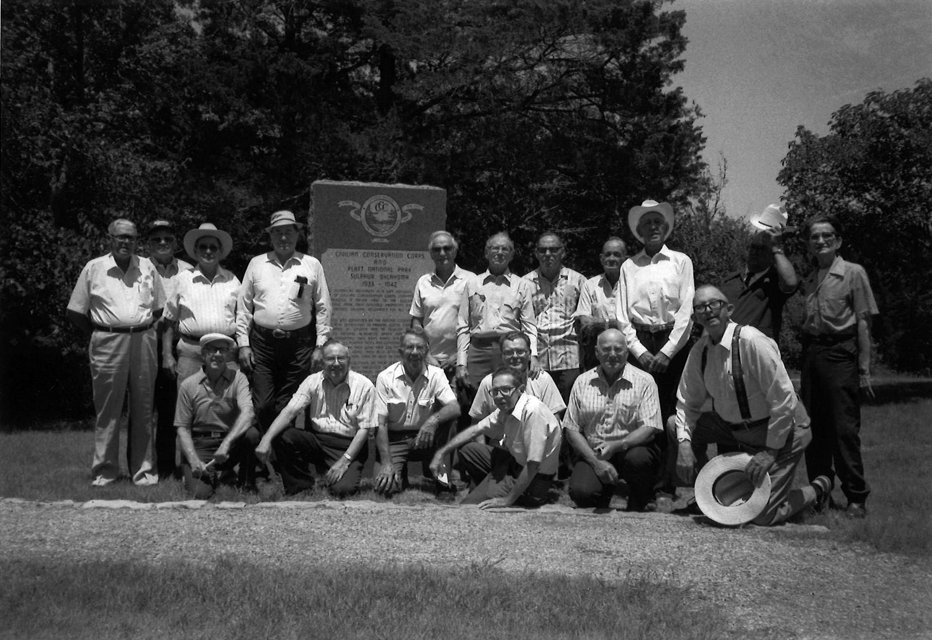
In the 1930s, young men of Civilian Conservation Corps (CCC) Company 808 contributed a major part to the building of Platt National Park, which was the only national park located in Oklahoma. The area is now part of the Chickasaw National Recreation Area.
Location: on I-35 at scenic turnout between mile markers 49 and 50
Note: Marker reported missing
Topics: Environmental/Cultural Ecology
Explains the Arbuckle Mountain Anticline geological structure. A nearby marker explains that the technique of oil exploration using reflection seismograph was born here.
Location: at Falls Creek Conference Center at Turner Falls south of Davis (OBHC)
Sponsored by: Baptist General Convention of Oklahoma
Topics: Transportation, Government, Religion/Philosophy, Early Statehood 1907–1941
Baptist leaders prayed here to dedicate the grounds to Baptist youth in 1917.
Location: the Turner Falls Scenic Turnout on Highway 77
Coordinates: 34.427300, -97.145737
Sponsored by: Citizens of Ardmore
Topics: Transportation
Two markers commemorating the construction of a highway through the Arbuckle Mountains. One is dedicated to George A. Ramsey, who initiated the highway’s construction. The other notes that the highway was constructed by prison laborers between 1925 and 1926.
Location: on US-177, eight miles south of Sulphur
Note: Marker reported missing
Topics: American Indians, Government, Social/Cultural
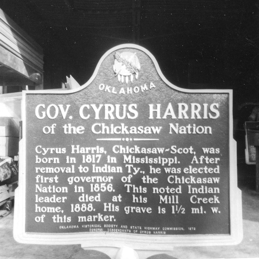
After adoption of a new constitution in 1856, the Chickasaws elected Cyrus Harris as the first governor of the Chickasaw Nation, a position he held for twenty-two years. Speaking both Chickasaw and English fluently, Harris was an interpreter at several early Chickasaw removal councils and represented the tribe in Washington, DC, in the 1850s.
Location: near OK-7 in the Arbuckle Mountains west of Davis
Topics: Settlement Patterns, Government, American Indians
Initial Point marks the exact location of the intersection of the north-south Indian Meridian and the east-west Base Line. Following the 1866 treaties with the Five Civilized Tribes, who agreed to the survey of their lands, the General Land Office in 1870 directed E. N. Darling to select the Indian Point (near Fort Arbuckle). The two lines he ran represent the basis of all future land descriptions in Oklahoma except the Panhandle. The rough stone pillar that marks Indian Point is on private land.
Location: the Turner Falls Scenic Turnout on Highway 77
Coordinates: 34.427285, -97.145737
Sponsored by: Oklahoma-Kansas Oil and Gas Association
Material: Granite
Topics: Environmental/Cultural Ecology
Oklahoma is the birthplace of the reflection seismic technique of oil exploration. This geophysical method records reflected seismic waves as they travel through the earth, helping to find oil-bearing formations. It has been responsible for the discovery of many of the world's largest oil and gas fields, containing billions of barrels of oil and trillions of cubic feet of natural gas. Pioneering research and development was led by Dr. J. C. Karcher, an Oklahoma physicist. The Arbuckle Mountains of Oklahoma were selected for a pilot survey of the technique and equipment because an entire geologic section from the basal permain to the basement mass of granite is exposed here. This survey followed limited testing in June 1921 in the outskirts of Oklahoma City. Verification and confirmation testing was conducted in the Arbuckles beginning July 4, 1921, by Dr. Karcher and Dr. W. P. Haseman, Dr. D. W. O'Hern, and Dr. Irving Perrine, of the University of Oklahoma. Results were promising. The world's first reflection seismograph geological section was measured on August 9, 1921, along Vines Branch a few miles north of Dougherty near here. The reflection technique has become the major method of energy exploration throughout the world. By 1983 more than 80 percent of the members of the Society of Exploration Geophysicists in 112 countries were involved in reflection seismography.
Location: at Falls Creek (OBHC)
Sponsored by: Baptist General Convention of Oklahoma
Topics: Religion/Philosophy, Recreational/Service, Early Statehood 1907–1941
In 1916, Baptist leaders saw a picture of the falls and wanted to purchase the land for a Baptist assembly. Price's Falls was not available, so Baptists bought land farther up the mountain and named it Falls Creek Baptist Assembly. In 1998, the Price's Falls area finally became part of the Baptists' Falls Creek complex.
Location: on OK-7/W. Broadway Ave. in Sulphur
Coordinates: 34.506250, -96.974183
Sponsored by: Rotary Club of Sulphur and OHS
Material: Aluminum with stone base
Topics: Environmental/Cultural Ecology, Natural Resources, Recreational/Service, Early Statehood 1907–1941
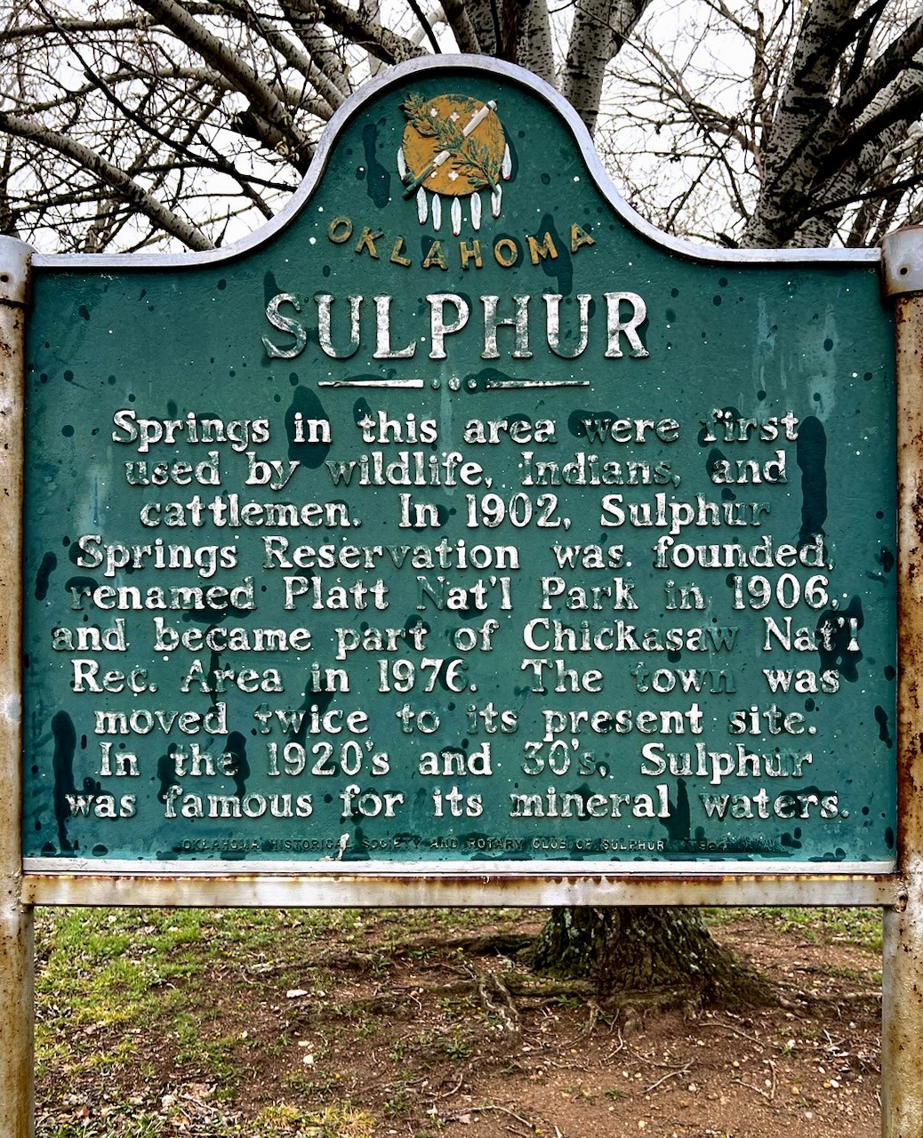
Springs in this area were first used by American Indians, wildlife, and cattlemen. In 1902 Sulphur Springs Reservation was founded, renamed Platt National Park in 1906, and became part of Chickasaw National Recreation Area in 1976. The town was moved twice to its present site in the 1920s and 1930s. Sulphur was famous for its mineral waters.
Lincoln County
Logan County
Love County
Major County
Marshall County
Mayes County
McClain County
McCurtain County
McIntosh County
Murray County
Muskogee County
Noble County
Okfuskee County
Oklahoma County
Okmulgee County
Osage County
Ottawa County
Pawnee County
Payne County
Pittsburg County
Pontotoc County
Pottawatomie County
Pushmataha County
Roger Mills County
Rogers County
Seminole County
Sequoyah County
Stephens County
Texas County
Tillman County
Tulsa County
Wagoner County
Washington County
Washita County
Woods County
Woodward County
Historical Marker Program
Search Results
Your search returned 11 results.
B. B. McKinney Cabin
Murray CountyLocation: at the Falls Creek Conference Center at Turner Falls south of Davis (OBHC)
Sponsored by: Baptist General Convention of Oklahoma
Topics: Religion/Philosophy, Arts, Social/Cultural
The legendary Southern Baptist composer, who directed music at Falls Creek from 1925 to 1947, wrote the song, "Wherever He Leads I'll Go," in this cabin.
Boulder Springs
Murray CountyLocation: at Falls Creek Conference Center at Turner Falls south of Davis (OBHC)
Sponsored by: Baptist General Convention of Oklahoma
Topics: Natural Resources, Water, Recreational/Service, Social/Cultural
The springs were formerly known as the "Devil's Bathtub," due to the unique shape of the pool.
Civilian Conservation Corps and Platt National Park, 1933–1942
Location: on Bison Road west of US 177, in Chickasaw National Recreation Area
Coordinates: 34.501550, -96.971633
Sponsored by: Oklahoma CCC Alumni and the Oklahoma Historical Society
Material: Granite
Topics: Government, Social/Cultural, Recreational/Service, Early Statehood 1907–1941
In the 1930s, young men of Civilian Conservation Corps (CCC) Company 808 contributed a major part to the building of Platt National Park, which was the only national park located in Oklahoma. The area is now part of the Chickasaw National Recreation Area.
Cross Section
Murray CountyLocation: on I-35 at scenic turnout between mile markers 49 and 50
Note: Marker reported missing
Topics: Environmental/Cultural Ecology
Explains the Arbuckle Mountain Anticline geological structure. A nearby marker explains that the technique of oil exploration using reflection seismograph was born here.
Falls Creek Memorial Park
Murray CountyLocation: at Falls Creek Conference Center at Turner Falls south of Davis (OBHC)
Sponsored by: Baptist General Convention of Oklahoma
Topics: Transportation, Government, Religion/Philosophy, Early Statehood 1907–1941
Baptist leaders prayed here to dedicate the grounds to Baptist youth in 1917.
George A. Ramsey and the Mountain Highway
Murray CountyLocation: the Turner Falls Scenic Turnout on Highway 77
Coordinates: 34.427300, -97.145737
Sponsored by: Citizens of Ardmore
Topics: Transportation
Two markers commemorating the construction of a highway through the Arbuckle Mountains. One is dedicated to George A. Ramsey, who initiated the highway’s construction. The other notes that the highway was constructed by prison laborers between 1925 and 1926.
Governor Cyrus Harris
Location: on US-177, eight miles south of Sulphur
Note: Marker reported missing
Topics: American Indians, Government, Social/Cultural
After adoption of a new constitution in 1856, the Chickasaws elected Cyrus Harris as the first governor of the Chickasaw Nation, a position he held for twenty-two years. Speaking both Chickasaw and English fluently, Harris was an interpreter at several early Chickasaw removal councils and represented the tribe in Washington, DC, in the 1850s.
Initial Point/Indian Meridian
Murray CountyLocation: near OK-7 in the Arbuckle Mountains west of Davis
Topics: Settlement Patterns, Government, American Indians
Initial Point marks the exact location of the intersection of the north-south Indian Meridian and the east-west Base Line. Following the 1866 treaties with the Five Civilized Tribes, who agreed to the survey of their lands, the General Land Office in 1870 directed E. N. Darling to select the Indian Point (near Fort Arbuckle). The two lines he ran represent the basis of all future land descriptions in Oklahoma except the Panhandle. The rough stone pillar that marks Indian Point is on private land.
Oklahoma, Where Reflection Seismograph Was Born
Murray CountyLocation: the Turner Falls Scenic Turnout on Highway 77
Coordinates: 34.427285, -97.145737
Sponsored by: Oklahoma-Kansas Oil and Gas Association
Material: Granite
Topics: Environmental/Cultural Ecology
Oklahoma is the birthplace of the reflection seismic technique of oil exploration. This geophysical method records reflected seismic waves as they travel through the earth, helping to find oil-bearing formations. It has been responsible for the discovery of many of the world's largest oil and gas fields, containing billions of barrels of oil and trillions of cubic feet of natural gas. Pioneering research and development was led by Dr. J. C. Karcher, an Oklahoma physicist. The Arbuckle Mountains of Oklahoma were selected for a pilot survey of the technique and equipment because an entire geologic section from the basal permain to the basement mass of granite is exposed here. This survey followed limited testing in June 1921 in the outskirts of Oklahoma City. Verification and confirmation testing was conducted in the Arbuckles beginning July 4, 1921, by Dr. Karcher and Dr. W. P. Haseman, Dr. D. W. O'Hern, and Dr. Irving Perrine, of the University of Oklahoma. Results were promising. The world's first reflection seismograph geological section was measured on August 9, 1921, along Vines Branch a few miles north of Dougherty near here. The reflection technique has become the major method of energy exploration throughout the world. By 1983 more than 80 percent of the members of the Society of Exploration Geophysicists in 112 countries were involved in reflection seismography.
Price's Falls
Murray CountyLocation: at Falls Creek (OBHC)
Sponsored by: Baptist General Convention of Oklahoma
Topics: Religion/Philosophy, Recreational/Service, Early Statehood 1907–1941
In 1916, Baptist leaders saw a picture of the falls and wanted to purchase the land for a Baptist assembly. Price's Falls was not available, so Baptists bought land farther up the mountain and named it Falls Creek Baptist Assembly. In 1998, the Price's Falls area finally became part of the Baptists' Falls Creek complex.
Sulphur
Location: on OK-7/W. Broadway Ave. in Sulphur
Coordinates: 34.506250, -96.974183
Sponsored by: Rotary Club of Sulphur and OHS
Material: Aluminum with stone base
Topics: Environmental/Cultural Ecology, Natural Resources, Recreational/Service, Early Statehood 1907–1941
Springs in this area were first used by American Indians, wildlife, and cattlemen. In 1902 Sulphur Springs Reservation was founded, renamed Platt National Park in 1906, and became part of Chickasaw National Recreation Area in 1976. The town was moved twice to its present site in the 1920s and 1930s. Sulphur was famous for its mineral waters.
(Page 1 of 1)
Search for Markers
Search by keyword or browse by county to learn about more than 700 historical markers created to recognize key locations, events, and people in Oklahoma history.
Please note that some markers listed in this database may have been moved, damaged, or are no longer standing.
Browse by County
Adair County
Alfalfa County
Atoka County
Beaver County
Beckham County
Blaine County
Bryan County
Caddo County
Canadian County
Carter County
Cherokee County
Choctaw County
Cimarron County
Cleveland County
Comanche County
Cotton County
Craig County
Creek County
Custer County
Delaware County
Dewey County
Ellis County
Garfield County
Garvin County
Grady County
Grant County
Greer County
Harmon County
Harper County
Haskell County
Hughes County
Jackson County
Jefferson County
Johnston County
Kay County
Kingfisher County
Kiowa County
Latimer County
Le Flore CountyAlfalfa County
Atoka County
Beaver County
Beckham County
Blaine County
Bryan County
Caddo County
Canadian County
Carter County
Cherokee County
Choctaw County
Cimarron County
Cleveland County
Comanche County
Cotton County
Craig County
Creek County
Custer County
Delaware County
Dewey County
Ellis County
Garfield County
Garvin County
Grady County
Grant County
Greer County
Harmon County
Harper County
Haskell County
Hughes County
Jackson County
Jefferson County
Johnston County
Kay County
Kingfisher County
Kiowa County
Latimer County
Lincoln County
Logan County
Love County
Major County
Marshall County
Mayes County
McClain County
McCurtain County
McIntosh County
Murray County
Muskogee County
Noble County
Okfuskee County
Oklahoma County
Okmulgee County
Osage County
Ottawa County
Pawnee County
Payne County
Pittsburg County
Pontotoc County
Pottawatomie County
Pushmataha County
Roger Mills County
Rogers County
Seminole County
Sequoyah County
Stephens County
Texas County
Tillman County
Tulsa County
Wagoner County
Washington County
Washita County
Woods County
Woodward County
Contact Us
If you have questions, please contact:
Matthew Pearce
Oklahoma Historical Society
800 Nazih Zuhdi Drive
Oklahoma City, OK 73105
405-522-8659
matthew.pearce@history.ok.gov