
Home | About OHS | Historical Marker Program
Location: in downtown Cheyenne one block south of US-283 and OK-47 intersection
Material: Granite
Topics: American Indians; Military; Territorial Period, 1861–1907
On November 27, 1868, Colonel George Armstrong Custer led the 7th Cavalry in an attack on Chief Black Kettle's camp on the Washita River. The surprise, early-morning attack decimated the Cheyenne camp and no doubt was the seed for Custer's later meeting with American Indians at the Battle of Little Big Horn.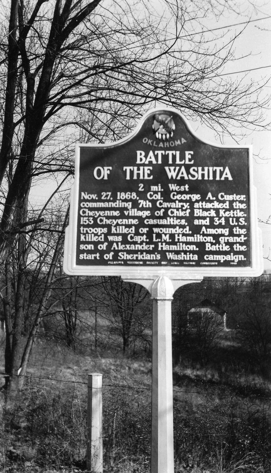
Location: on E1080 Rd approximately 2 miles west of US-283
Coordinates: 35.450837, -99.624696
Material: Granite
Sponsor(s): Berlin Extension Homemakers
Topics: Settlement Patterns; Territorial Period, 1861–1907
Originally known as Doxey, a post office was established in the vicinity in January 1894. Post office name changed to Berlin in September 1896. Named for Berlin, Germany, the town name is pronounced locally as “BUR-lin” because of anti-German sentiment during World War I. Berlin’s post office and school closed in 1967. Marker is dedicated to the settlers who persevered through “drought, flood, sickness, debt, and a multitude of other misfortunes” to establish the community.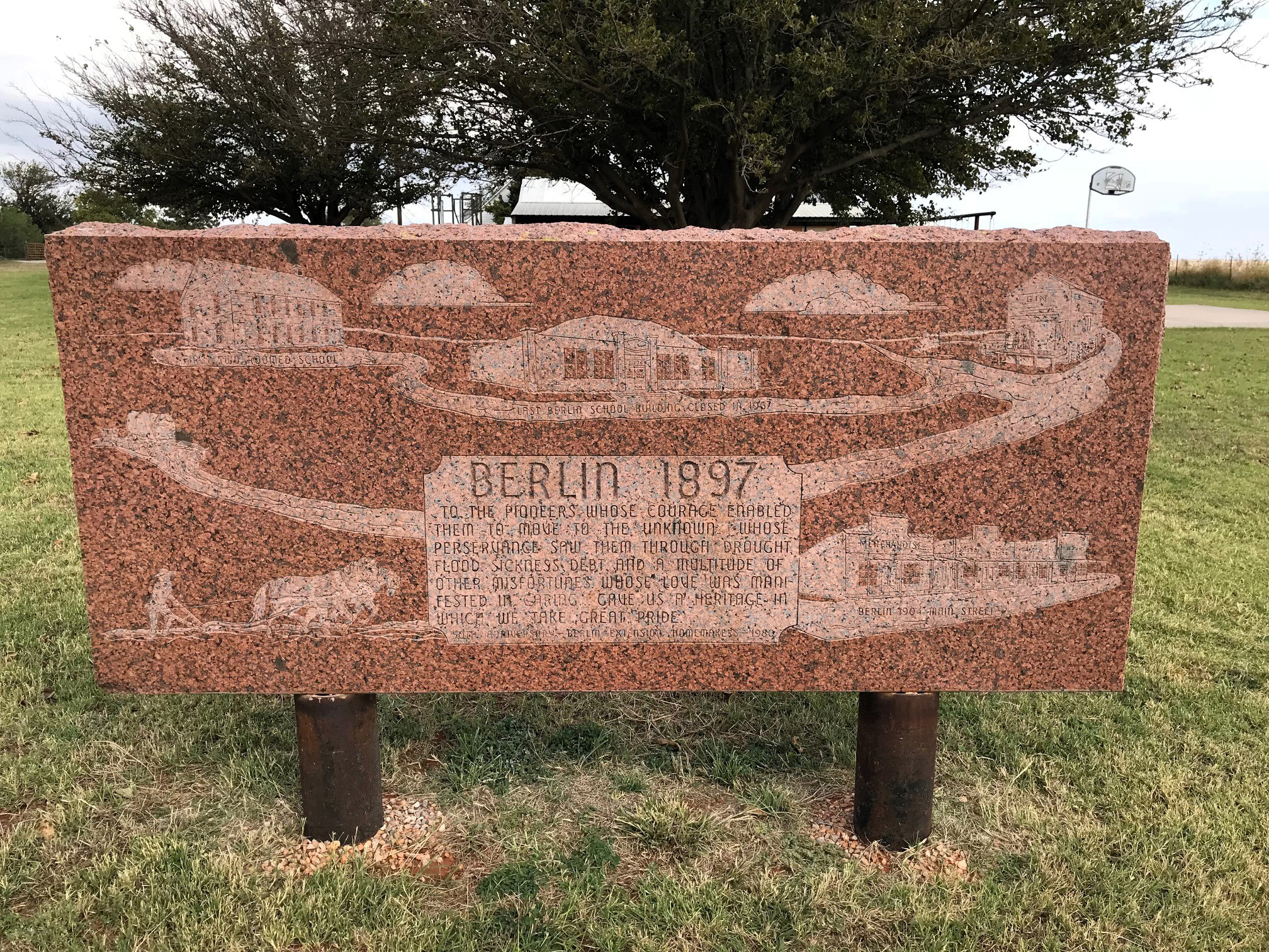
Location: at junction of US-283 and OK-33, 14 miles north of Cheyenne
Coordinates: 35.797609, -99.723281
Material: Aluminum
Sponsor(s): Oklahoma Historical Society and the Oklahoma Department of Transportation
Topics: Government; Environmental/Cultural Ecology; Industrial Period, 1941 to 1982; Settlement Patterns; Transportation; Water; Westward Expansion, 1803–1861
First traveled by gold seekers in the rush for California in the spring of 1849, under military escort commanded by Capt. R. B. Marcy, west from Fort Smith, Arkansas. Antelope Hills, 8 miles northwest, were once a landmark for the international line between the United States and Mexico. Little Robe Creek, northwest of hills, is site of Comanche battle with Texas Rangers, Capt. John S. Ford, in 1858.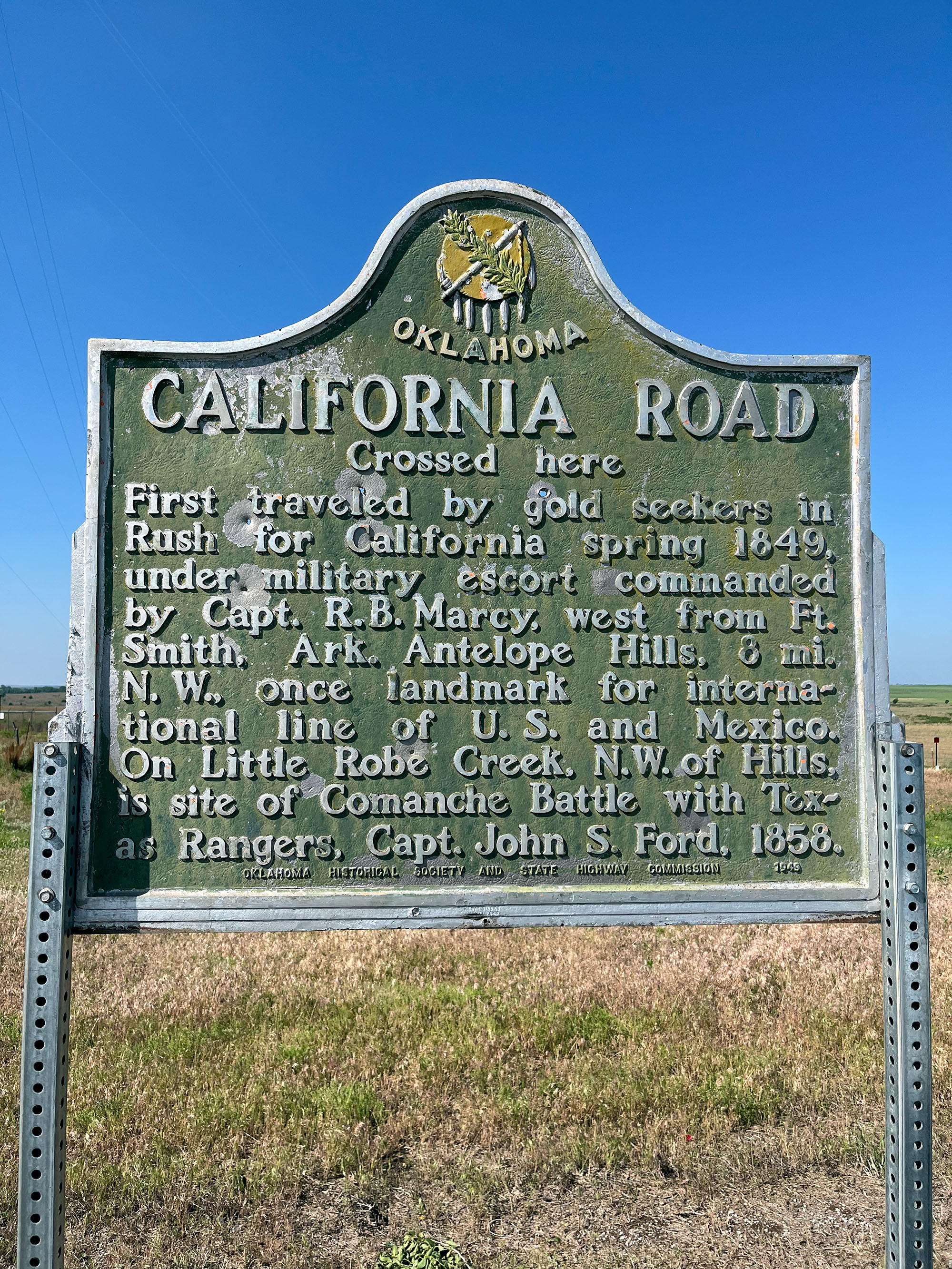
Location: on US-283, ten miles south of Cheyenne
The site of the world's first upstream flood prevention project that was completed in 1953 and drains more than 68,000 acres.
(Page 1 of 1)
Lincoln County
Logan County
Love County
Major County
Marshall County
Mayes County
McClain County
McCurtain County
McIntosh County
Murray County
Muskogee County
Noble County
Okfuskee County
Oklahoma County
Okmulgee County
Osage County
Ottawa County
Pawnee County
Payne County
Pittsburg County
Pontotoc County
Pottawatomie County
Pushmataha County
Roger Mills County
Rogers County
Seminole County
Sequoyah County
Stephens County
Texas County
Tillman County
Tulsa County
Wagoner County
Washington County
Washita County
Woods County
Woodward County
Historical Marker Program
Search Results
Your search returned 4 results.
Battle of the Washita
Roger Mills CountyLocation: in downtown Cheyenne one block south of US-283 and OK-47 intersection
Material: Granite
Topics: American Indians; Military; Territorial Period, 1861–1907
On November 27, 1868, Colonel George Armstrong Custer led the 7th Cavalry in an attack on Chief Black Kettle's camp on the Washita River. The surprise, early-morning attack decimated the Cheyenne camp and no doubt was the seed for Custer's later meeting with American Indians at the Battle of Little Big Horn.
Berlin
Roger Mills CountyLocation: on E1080 Rd approximately 2 miles west of US-283
Coordinates: 35.450837, -99.624696
Material: Granite
Sponsor(s): Berlin Extension Homemakers
Topics: Settlement Patterns; Territorial Period, 1861–1907
Originally known as Doxey, a post office was established in the vicinity in January 1894. Post office name changed to Berlin in September 1896. Named for Berlin, Germany, the town name is pronounced locally as “BUR-lin” because of anti-German sentiment during World War I. Berlin’s post office and school closed in 1967. Marker is dedicated to the settlers who persevered through “drought, flood, sickness, debt, and a multitude of other misfortunes” to establish the community.
California Road
Roger Mills CountyLocation: at junction of US-283 and OK-33, 14 miles north of Cheyenne
Coordinates: 35.797609, -99.723281
Material: Aluminum
Sponsor(s): Oklahoma Historical Society and the Oklahoma Department of Transportation
Topics: Government; Environmental/Cultural Ecology; Industrial Period, 1941 to 1982; Settlement Patterns; Transportation; Water; Westward Expansion, 1803–1861
First traveled by gold seekers in the rush for California in the spring of 1849, under military escort commanded by Capt. R. B. Marcy, west from Fort Smith, Arkansas. Antelope Hills, 8 miles northwest, were once a landmark for the international line between the United States and Mexico. Little Robe Creek, northwest of hills, is site of Comanche battle with Texas Rangers, Capt. John S. Ford, in 1858.
Sandstone Creek Area
Roger Mills CountyLocation: on US-283, ten miles south of Cheyenne
The site of the world's first upstream flood prevention project that was completed in 1953 and drains more than 68,000 acres.
(Page 1 of 1)
Search for Markers
Search by marker name or browse by county or subject to learn about more than 700 historical markers recognizing key locations, events, and people in Oklahoma history.
This database contains markers sponsored by the Oklahoma Historical Society and markers created by other organizations. Please note that some markers listed may have been relocated, damaged, or no longer exist.
Browse by County
Adair County
Alfalfa County
Atoka County
Beaver County
Beckham County
Blaine County
Bryan County
Caddo County
Canadian County
Carter County
Cherokee County
Choctaw County
Cimarron County
Cleveland County
Comanche County
Cotton County
Craig County
Creek County
Custer County
Delaware County
Dewey County
Ellis County
Garfield County
Garvin County
Grady County
Grant County
Greer County
Harmon County
Harper County
Haskell County
Hughes County
Jackson County
Jefferson County
Johnston County
Kay County
Kingfisher County
Kiowa County
Latimer County
Le Flore CountyAlfalfa County
Atoka County
Beaver County
Beckham County
Blaine County
Bryan County
Caddo County
Canadian County
Carter County
Cherokee County
Choctaw County
Cimarron County
Cleveland County
Comanche County
Cotton County
Craig County
Creek County
Custer County
Delaware County
Dewey County
Ellis County
Garfield County
Garvin County
Grady County
Grant County
Greer County
Harmon County
Harper County
Haskell County
Hughes County
Jackson County
Jefferson County
Johnston County
Kay County
Kingfisher County
Kiowa County
Latimer County
Lincoln County
Logan County
Love County
Major County
Marshall County
Mayes County
McClain County
McCurtain County
McIntosh County
Murray County
Muskogee County
Noble County
Okfuskee County
Oklahoma County
Okmulgee County
Osage County
Ottawa County
Pawnee County
Payne County
Pittsburg County
Pontotoc County
Pottawatomie County
Pushmataha County
Roger Mills County
Rogers County
Seminole County
Sequoyah County
Stephens County
Texas County
Tillman County
Tulsa County
Wagoner County
Washington County
Washita County
Woods County
Woodward County
Contact Us
If you have questions, please contact:
Matthew Pearce
Oklahoma Historical Society
800 Nazih Zuhdi Drive
Oklahoma City, OK 73105
405-522-8659
matthew.pearce@history.ok.gov