
Home | About OHS | Historical Marker Program
Sponsored by: Student Council and Patrons of Paden, 1987-1988
Material: Granite
Topics: Petroleum, Natural Resources, Industry/Business, American Indians, UB, Social/Cultural, Government, Folklife, Ethnic Diversity, Education
The Cromwell oil field and town were named for Joe I. Cromwell of Muskogee, Oklahoma. A gas well, the #1 Jim Willis in the SE/4 SE/4NW/4 of Section 15-10N-8E, was completed at a depth of 3,466 feet by the Cosden Oil Co. on November 11, 1922. However, it was not until the discovery of oil by the Cromwell Oil & Gas Company at the #1 Bruner in the NW/4 NE/4 SW/4 of Section 15-10N-8E on October 2, 1923, that the drilling boom started. This well was completed to a depth of 3,475 feet. A total of 393 wells produced oil in the field with the largest oil well producing 5,600 barrels per day, and the largest gas well producing 125,000,000 M.C.F. The town of Cromwell and the surrounding oil field had a peak population of 10,000 during 1923 and 1924. Lawlessness became rampant and caused the town to be named "Cromwell the Wicked". In September 1924, prisoners from Cromwell were handcuffed to a log cabin and marched 14 miles to the county jail in Wewoka. To help curb the lawlessness in the town, William (Bill) Tilghman, a pioneer law officer and one of the famous "Three Guardsmen" of Oklahoma was named Chief of Police in September 1924. On November 1, 1924, at the age of seventy, Tilghman was slain at the entrance of Murphy's dance hall located where this marker stands.
Location: in Seminole county, five miles south of Wewoka at intersection of US-270 and State-56
Topics: American Indians, Education
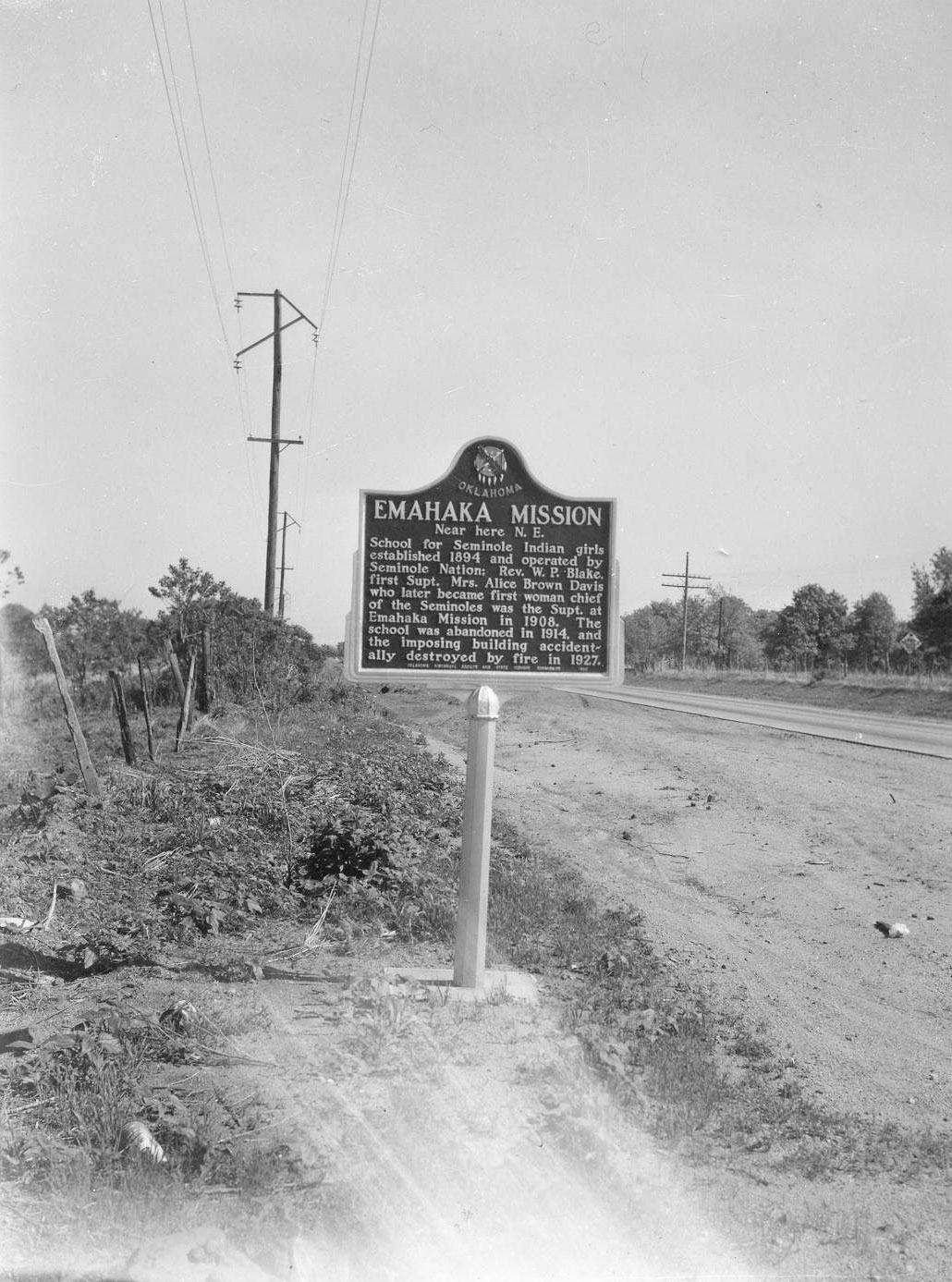
A school for Seminole Indian girls was established in 1894 operated by the Seminole Nation. Reverend W.P. Blake was the first superintendent. Mrs. Alice Brown Davis, who later became first female chief of the Seminole, was the superintendent in 1908 at Emahaka Mission. The school was abandoned in 1914, in a closing of Seminole government properties.
Location: in community of Lima
Topics: Ethnic Diversity, Territorial Period 1861–1907, Early Statehood 1907–1941, Settlement Patterns, Urban Development, Education
Lima is one of thirteen All-Black towns, out of more than fifty that once existed, remaining in Oklahoma. While Tullahassee is reportedly the oldest, most were established between 1889 and 1907 as African Americans sought security and control of their own destiny in a segregated world. Most of the towns began to decline in the 1920s and 1930s as rural African Americans faced economic hardships and began to move to urban areas. Lima had a post office from 1907 to 1957. It is the site of a Rosenwald School, which was constructed in 1921 with funding from Julius Rosenwald, president of Sears, Roebuck and Company and trustee of the Tuskegee Institute.
Location: on OK-59, four miles southwest of Seminole
Topics: Education, American Indians, Early Statehood 1907–1941
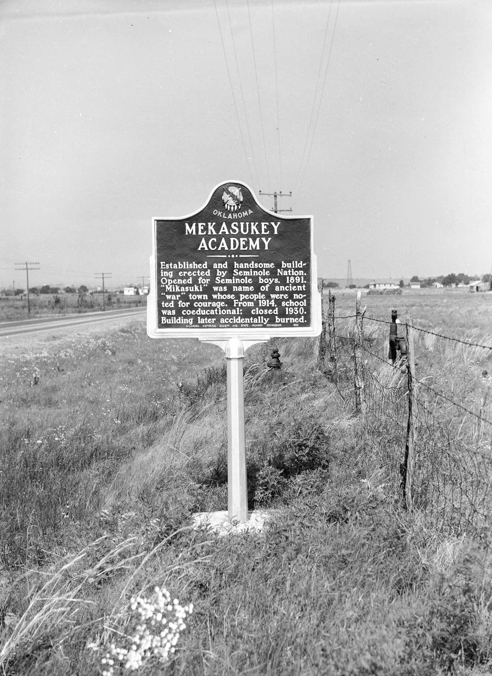
Opened in 1891, this school educated Seminole boys until it became coeducational in 1914. The name came from an ancient Seminole war town. The school closed in 1930.
Location: on SH56, two miles west of Sasakwa
Material: Aluminum
Topics: American Indians, Government, Religion/Philosophy, Westward Expansion 1803–1861
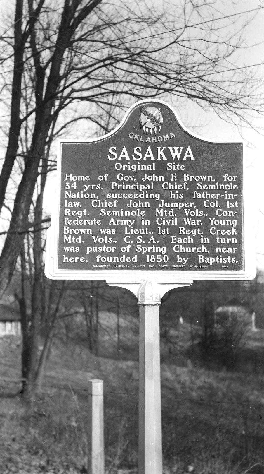
Home of Governor John F. Brown for fifty-four year who was Principal Chief of the Seminole Nation, succeeding his father-inaw. Chief John Jumper, Col 1st Reft. Seminole Mtd: Vols. Confederate Army in Civil War. Young Brown was Lieut., 1st Reft. Creek Mid. Vols. C.S.A. Each in turn was pastor of Spring Church, near here, founded 1850 by Baptists.
Le Flore County
Lincoln County
Logan County
Love County
Marshall County
Mayes County
McClain County
McCurtain County
McIntosh County
Murray County
Muskogee County
Noble County
Okfuskee County
Oklahoma County
Okmulgee County
Osage County
Ottawa County
Pawnee County
Payne County
Pittsburg County
Pontotoc County
Pottawatomie County
Pushmataha County
Roger Mills County
Rogers County
Seminole County
Sequoyah County
Stephens County
Texas County
Tillman County
Tulsa County
Wagoner County
Washington County
Washita County
Woods County
Woodward County
Historical Marker Program
Search Results
Your search returned 5 results.
Cromwell
Seminole CountySponsored by: Student Council and Patrons of Paden, 1987-1988
Material: Granite
Topics: Petroleum, Natural Resources, Industry/Business, American Indians, UB, Social/Cultural, Government, Folklife, Ethnic Diversity, Education
The Cromwell oil field and town were named for Joe I. Cromwell of Muskogee, Oklahoma. A gas well, the #1 Jim Willis in the SE/4 SE/4NW/4 of Section 15-10N-8E, was completed at a depth of 3,466 feet by the Cosden Oil Co. on November 11, 1922. However, it was not until the discovery of oil by the Cromwell Oil & Gas Company at the #1 Bruner in the NW/4 NE/4 SW/4 of Section 15-10N-8E on October 2, 1923, that the drilling boom started. This well was completed to a depth of 3,475 feet. A total of 393 wells produced oil in the field with the largest oil well producing 5,600 barrels per day, and the largest gas well producing 125,000,000 M.C.F. The town of Cromwell and the surrounding oil field had a peak population of 10,000 during 1923 and 1924. Lawlessness became rampant and caused the town to be named "Cromwell the Wicked". In September 1924, prisoners from Cromwell were handcuffed to a log cabin and marched 14 miles to the county jail in Wewoka. To help curb the lawlessness in the town, William (Bill) Tilghman, a pioneer law officer and one of the famous "Three Guardsmen" of Oklahoma was named Chief of Police in September 1924. On November 1, 1924, at the age of seventy, Tilghman was slain at the entrance of Murphy's dance hall located where this marker stands.
Emahaka Mission
Seminole CountyLocation: in Seminole county, five miles south of Wewoka at intersection of US-270 and State-56
Topics: American Indians, Education
A school for Seminole Indian girls was established in 1894 operated by the Seminole Nation. Reverend W.P. Blake was the first superintendent. Mrs. Alice Brown Davis, who later became first female chief of the Seminole, was the superintendent in 1908 at Emahaka Mission. The school was abandoned in 1914, in a closing of Seminole government properties.
Lima
Seminole CountyLocation: in community of Lima
Topics: Ethnic Diversity, Territorial Period 1861–1907, Early Statehood 1907–1941, Settlement Patterns, Urban Development, Education
Lima is one of thirteen All-Black towns, out of more than fifty that once existed, remaining in Oklahoma. While Tullahassee is reportedly the oldest, most were established between 1889 and 1907 as African Americans sought security and control of their own destiny in a segregated world. Most of the towns began to decline in the 1920s and 1930s as rural African Americans faced economic hardships and began to move to urban areas. Lima had a post office from 1907 to 1957. It is the site of a Rosenwald School, which was constructed in 1921 with funding from Julius Rosenwald, president of Sears, Roebuck and Company and trustee of the Tuskegee Institute.
Mekasukey Academy
Seminole CountyLocation: on OK-59, four miles southwest of Seminole
Topics: Education, American Indians, Early Statehood 1907–1941
Opened in 1891, this school educated Seminole boys until it became coeducational in 1914. The name came from an ancient Seminole war town. The school closed in 1930.
Sasakwa
Seminole CountyLocation: on SH56, two miles west of Sasakwa
Material: Aluminum
Topics: American Indians, Government, Religion/Philosophy, Westward Expansion 1803–1861
Home of Governor John F. Brown for fifty-four year who was Principal Chief of the Seminole Nation, succeeding his father-inaw. Chief John Jumper, Col 1st Reft. Seminole Mtd: Vols. Confederate Army in Civil War. Young Brown was Lieut., 1st Reft. Creek Mid. Vols. C.S.A. Each in turn was pastor of Spring Church, near here, founded 1850 by Baptists.
(Page 1 of 1)
Search for Markers
Search by keyword or browse by county to learn about more than 600 historical markers created to recognize key locations, events, and people in Oklahoma history.
Please note that some markers listed in this database may have been moved, damaged, or are no longer standing.
Browse by County
Adair County
Alfalfa County
Atoka County
Beaver County
Beckham County
Blaine County
Bryan County
Caddo County
Canadian County
Carter County
Cherokee County
Choctaw County
Cimarron County
Cleveland County
Comanche County
Cotton County
Craig County
Creek County
Custer County
Delaware County
Dewey County
Ellis County
Garfield County
Garvin County
Grady County
Grant County
Greer County
Harmon County
Harper County
Haskell County
Hughes County
Jackson County
Jefferson County
Johnston County
Kay County
Kingfisher County
Kiowa County
Latimer CountyAlfalfa County
Atoka County
Beaver County
Beckham County
Blaine County
Bryan County
Caddo County
Canadian County
Carter County
Cherokee County
Choctaw County
Cimarron County
Cleveland County
Comanche County
Cotton County
Craig County
Creek County
Custer County
Delaware County
Dewey County
Ellis County
Garfield County
Garvin County
Grady County
Grant County
Greer County
Harmon County
Harper County
Haskell County
Hughes County
Jackson County
Jefferson County
Johnston County
Kay County
Kingfisher County
Kiowa County
Le Flore County
Lincoln County
Logan County
Love County
Marshall County
Mayes County
McClain County
McCurtain County
McIntosh County
Murray County
Muskogee County
Noble County
Okfuskee County
Oklahoma County
Okmulgee County
Osage County
Ottawa County
Pawnee County
Payne County
Pittsburg County
Pontotoc County
Pottawatomie County
Pushmataha County
Roger Mills County
Rogers County
Seminole County
Sequoyah County
Stephens County
Texas County
Tillman County
Tulsa County
Wagoner County
Washington County
Washita County
Woods County
Woodward County
Contact Us
If you have questions, please contact:
Matthew Pearce
Oklahoma Historical Society
800 Nazih Zuhdi Drive
Oklahoma City, OK 73105
405-522-8659
matthew.pearce@history.ok.gov