
Home | About OHS | Historical Marker Program
Location: one mile north and 1/4 mile west of intersection of OK-18 and OK-51, four miles west of Yale
Material: Granite
Topics: Military, Government, American Indians, Westward Expansion 1803–1861
Between the landmark known as Round Mountain (Twin Mounds) to the south and a camp on Salt Creek two miles northwest, the first battle of the Civil War in Oklahoma was fought between a group of loyal Creeks under Opothleyahola and Confederate forces led by Colonel Douglas H. Cooper. Some scholars believe this engagement took place in Tulsa County.
Location: just west of North Perkins Road in Stillwater
Topics: Government, Land Openings, Settlement Patterns, Territorial Period 1861–1907
The federal government established this booth where thousands registered for the opening of the Cherokee Outlet on September 16, 1893.
Location: at intersection of Ranch Street and Washington Avenue in Stillwater
Material: Aluminum
Topics: Government, Land Openings, Settlement Patterns, Territorial Period 1861–1907, Agriculture
From this line, tens of thousands of settlers raced to stake 160-acre homesteads in the Unassigned Lands in the land run of 1889. This was also the boundary for the opening of the Cherokee Outlet four years later in 1893.
Location: at grave site of David Payne in Boomer Lake Park at Washington and Lakeview in Stillwater
Topics: Land Openings, Settlement Patterns, Social/Cultural
David Payne was the father of the Oklahoma Boomer movement. After his death, he was buried in Kansas. His remains were moved to Stillwater in January 1995.
Location: on Mehan Road northeast of Ripley (DAR)
Sponsored by: Daughters of the American Revolution
Topics: Westward Expansion 1803–1861, Arts, Natural Resources
Writer Washington Irving camped here on October 20, 1832, in his tour of the American prairie. In his description of the campground, Irving wrote, "It reminded me of the ruin of some Moorish castle, crowning a height in the midst of a lonely Spanish landscape.
Location: in Jim Thorpe Municipal Park in Yale
Topics: American Indians, Social/Cultural, Folklife, Territorial Period 1861–1907
In 1912, Jim Thorpe won both the decathlon and pentathlon in the Olympics and was praised for his athletic prowess by the entire world. He played both professional baseball and football and is considered one of the greatest athletes of American sports history.
Location: at 706 East Boston in Yale
Material: Aluminum
Topics: American Indians, Social/Cultural, Folklife, Territorial Period 1861–1907
This was the home of the Thorpe family beginning in 1917.
Location: on OK-40 near south edge of Stillwater
Material: Aluminum
Topics: Land Openings, Settlement Patterns, Social/Cultural, Military, Territorial Period 1861–1907
Boomers were followers of David L. Payne, who insisted upon the opening of central Oklahoma to settlement. Near here, 300 armed Boomers made their last stand for settlement of the Oklahoma country when they surrendered to US cavalry troops. The Boomers had built log cabins and dugouts and founded the town of Stillwater on December 12, 1884.
Location: at intersection of Adams and Harrison in Cushing
Material: Granite
Topics: Petroleum, Natural Resources, Industry/Business, Urban Development, Government, Mass Communication
In March 1912, Tom Slick and C. B. Shafer discovered oil nearby. The Cushing field became one of history's greatest oil finds. For eight years, it led the nation in oil production. The oil discovery turned Cushing into a boomtown. The post office of Cushing was established November 10, 1891. The town was named for Marshall Cushing, private secretary to Postmaster General John Wanamaker. In 1919, the Cushing-Drumright area accounted for 17 percent of the nation's oil production.
Location: on South Main Street at south edge of Stillwater
Material: Aluminum
Topics: Education, Territorial Period 1861–1907, Government
The college, now Oklahoma State University, was established December 25, 1890, by the Oklahoma territorial legislature. The prairie was broken for establishment of an experimental farm in 1891.
Location: on Oklahoma State University campus in Stillwater
Topics: Government, Social/Cultural, Recreational/Service
The Oklahoma Museum of Higher Education is housed in Old Central, built in 1894, the first permanent building on the OSU campus. It is the nation's only museum devoted to a state's higher education history.
Location: at intersection of OK-51 and Bethel Road east of Stillwater
Topics: Government, Folklife, Territorial Period 1861–1907
Three US marshals and two citizens were killed in a September 1, 1893, gunfight between lawmen and members of the Dalton-Doolin outlaw gang. It was the beginning of the end of the notorious outlaw gang.
Location: southeast of Ripley
Location: at Sixth Avenue and Perkins Road in Stillwater
Topics: Land Openings, Settlement Patterns, Social/Cultural, Territorial Period 1861–1907, Urban Development
Boomers, led by William C. Couch, settled nearby on Stillwater Creek in December 1884. When ordered to leave, they defied the US cavalry. In his wire for reinforcements, Lieutenant Mathias Day said, "They call this place Stillwater," the first recorded reference to a town in Oklahoma Territory. The Boomers departed, but Stillwater was settled in the first hour of the Land Run on April 22, 1889.
Location: at junction of OK-99 and OK-33
Material: Aluminum
Topics: Ranching, Transportation, Territorial Period 1861–1907
During the height of the Texas trail drives through Oklahoma, this ranch, owned by James Jerome and Leslie Combs, was used to fatten cattle before their final trip to markets in Kansas. Roundups were held on the present site of Cushing.
Location: in the Jim Thorpe Municipal Park in Yale
Topics: Arts, Westward Expansion 1803–1861, Folklife
Washington Irving camped nearby during his tour of the prairies in 1832.
Location: nine miles south of Stillwater, four miles west, and one mile north of OK-33
Topics: Westward Expansion 1803–1861, Arts, Folklife
Writer Washington Irving and his party camped on Wild Horse Creek during his tour of the prairies in 1832.
Le Flore County
Lincoln County
Logan County
Love County
Marshall County
Mayes County
McClain County
McCurtain County
McIntosh County
Murray County
Muskogee County
Noble County
Okfuskee County
Oklahoma County
Okmulgee County
Osage County
Ottawa County
Pawnee County
Payne County
Pittsburg County
Pontotoc County
Pottawatomie County
Pushmataha County
Roger Mills County
Rogers County
Seminole County
Sequoyah County
Stephens County
Texas County
Tillman County
Tulsa County
Wagoner County
Washington County
Washita County
Woods County
Woodward County
Historical Marker Program
Search Results
Your search returned 17 results.
Battle of Round Mountain
Payne CountyLocation: one mile north and 1/4 mile west of intersection of OK-18 and OK-51, four miles west of Yale
Material: Granite
Topics: Military, Government, American Indians, Westward Expansion 1803–1861
Between the landmark known as Round Mountain (Twin Mounds) to the south and a camp on Salt Creek two miles northwest, the first battle of the Civil War in Oklahoma was fought between a group of loyal Creeks under Opothleyahola and Confederate forces led by Colonel Douglas H. Cooper. Some scholars believe this engagement took place in Tulsa County.
Booth Number One
Payne CountyLocation: just west of North Perkins Road in Stillwater
Topics: Government, Land Openings, Settlement Patterns, Territorial Period 1861–1907
The federal government established this booth where thousands registered for the opening of the Cherokee Outlet on September 16, 1893.
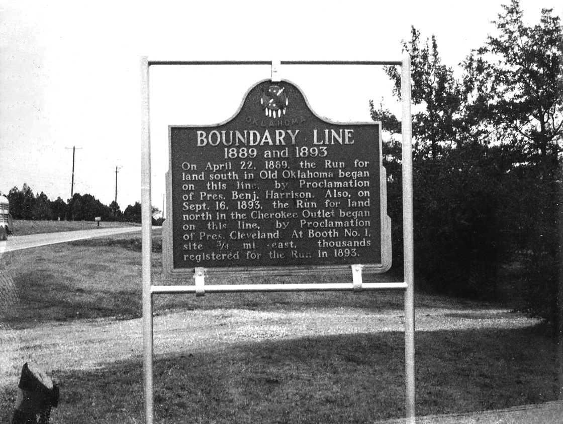
Boundary Line 1889 and 1893
Payne CountyLocation: at intersection of Ranch Street and Washington Avenue in Stillwater
Material: Aluminum
Topics: Government, Land Openings, Settlement Patterns, Territorial Period 1861–1907, Agriculture
From this line, tens of thousands of settlers raced to stake 160-acre homesteads in the Unassigned Lands in the land run of 1889. This was also the boundary for the opening of the Cherokee Outlet four years later in 1893.
David Payne
Payne CountyLocation: at grave site of David Payne in Boomer Lake Park at Washington and Lakeview in Stillwater
Topics: Land Openings, Settlement Patterns, Social/Cultural
David Payne was the father of the Oklahoma Boomer movement. After his death, he was buried in Kansas. His remains were moved to Stillwater in January 1995.
Irving's Castle
Payne CountyLocation: on Mehan Road northeast of Ripley (DAR)
Sponsored by: Daughters of the American Revolution
Topics: Westward Expansion 1803–1861, Arts, Natural Resources
Writer Washington Irving camped here on October 20, 1832, in his tour of the American prairie. In his description of the campground, Irving wrote, "It reminded me of the ruin of some Moorish castle, crowning a height in the midst of a lonely Spanish landscape.
Jim Thorpe
Payne CountyLocation: in Jim Thorpe Municipal Park in Yale
Topics: American Indians, Social/Cultural, Folklife, Territorial Period 1861–1907
In 1912, Jim Thorpe won both the decathlon and pentathlon in the Olympics and was praised for his athletic prowess by the entire world. He played both professional baseball and football and is considered one of the greatest athletes of American sports history.
Jim Thorpe
Payne CountyLocation: at 706 East Boston in Yale
Material: Aluminum
Topics: American Indians, Social/Cultural, Folklife, Territorial Period 1861–1907
This was the home of the Thorpe family beginning in 1917.
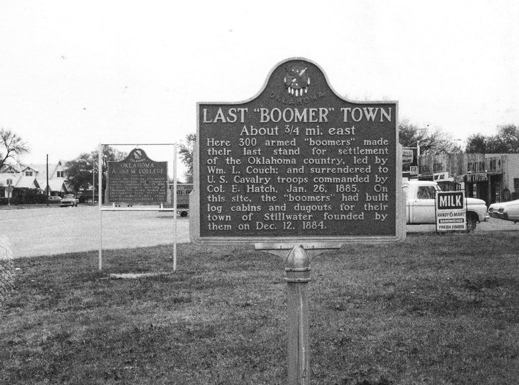
Last Boomer Town
Payne CountyLocation: on OK-40 near south edge of Stillwater
Material: Aluminum
Topics: Land Openings, Settlement Patterns, Social/Cultural, Military, Territorial Period 1861–1907
Boomers were followers of David L. Payne, who insisted upon the opening of central Oklahoma to settlement. Near here, 300 armed Boomers made their last stand for settlement of the Oklahoma country when they surrendered to US cavalry troops. The Boomers had built log cabins and dugouts and founded the town of Stillwater on December 12, 1884.
Oil in the Cushing-Drumright Area
Payne CountyLocation: at intersection of Adams and Harrison in Cushing
Material: Granite
Topics: Petroleum, Natural Resources, Industry/Business, Urban Development, Government, Mass Communication
In March 1912, Tom Slick and C. B. Shafer discovered oil nearby. The Cushing field became one of history's greatest oil finds. For eight years, it led the nation in oil production. The oil discovery turned Cushing into a boomtown. The post office of Cushing was established November 10, 1891. The town was named for Marshall Cushing, private secretary to Postmaster General John Wanamaker. In 1919, the Cushing-Drumright area accounted for 17 percent of the nation's oil production.
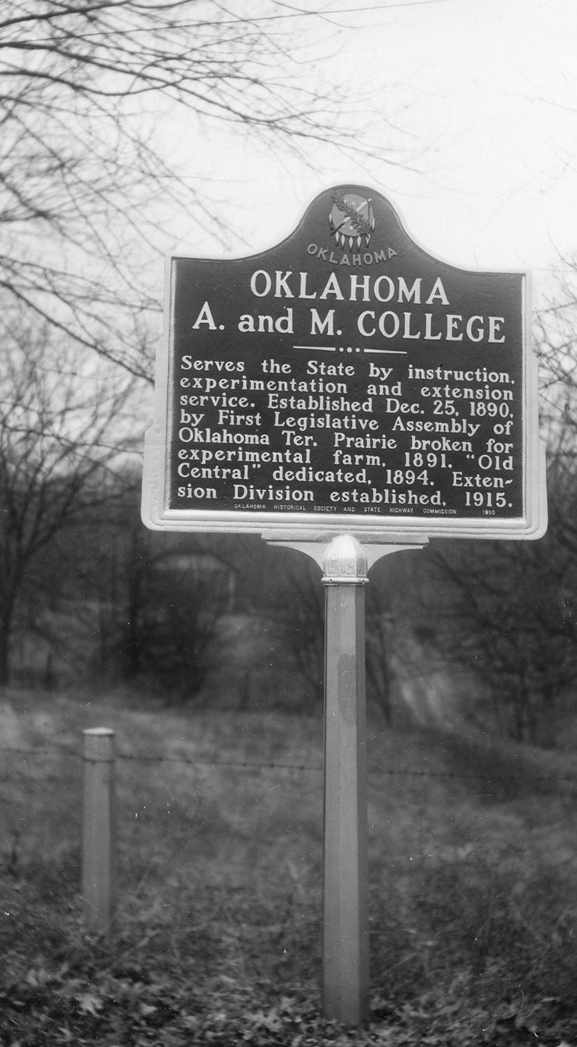
Oklahoma A&M College
Payne CountyLocation: on South Main Street at south edge of Stillwater
Material: Aluminum
Topics: Education, Territorial Period 1861–1907, Government
The college, now Oklahoma State University, was established December 25, 1890, by the Oklahoma territorial legislature. The prairie was broken for establishment of an experimental farm in 1891.
Oklahoma Museum of Higher Education
Payne CountyLocation: on Oklahoma State University campus in Stillwater
Topics: Government, Social/Cultural, Recreational/Service
The Oklahoma Museum of Higher Education is housed in Old Central, built in 1894, the first permanent building on the OSU campus. It is the nation's only museum devoted to a state's higher education history.
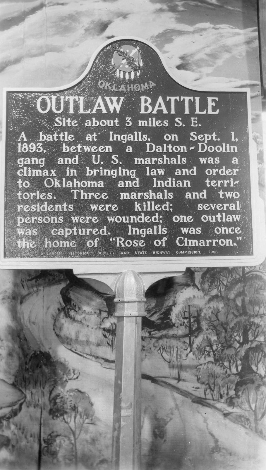
Outlaw Battle
Payne CountyLocation: at intersection of OK-51 and Bethel Road east of Stillwater
Topics: Government, Folklife, Territorial Period 1861–1907
Three US marshals and two citizens were killed in a September 1, 1893, gunfight between lawmen and members of the Dalton-Doolin outlaw gang. It was the beginning of the end of the notorious outlaw gang.
Ripley's Oak Park Cemetery
Payne CountyLocation: southeast of Ripley
Stillwater
Payne CountyLocation: at Sixth Avenue and Perkins Road in Stillwater
Topics: Land Openings, Settlement Patterns, Social/Cultural, Territorial Period 1861–1907, Urban Development
Boomers, led by William C. Couch, settled nearby on Stillwater Creek in December 1884. When ordered to leave, they defied the US cavalry. In his wire for reinforcements, Lieutenant Mathias Day said, "They call this place Stillwater," the first recorded reference to a town in Oklahoma Territory. The Boomers departed, but Stillwater was settled in the first hour of the Land Run on April 22, 1889.
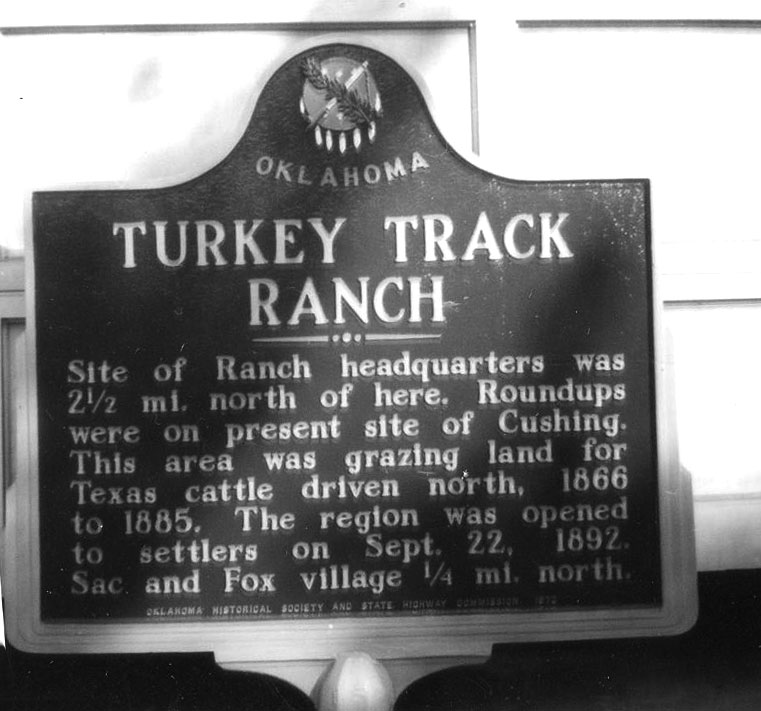
Turkey Track Ranch
Payne CountyLocation: at junction of OK-99 and OK-33
Material: Aluminum
Topics: Ranching, Transportation, Territorial Period 1861–1907
During the height of the Texas trail drives through Oklahoma, this ranch, owned by James Jerome and Leslie Combs, was used to fatten cattle before their final trip to markets in Kansas. Roundups were held on the present site of Cushing.
Washington Irving
Payne CountyLocation: in the Jim Thorpe Municipal Park in Yale
Topics: Arts, Westward Expansion 1803–1861, Folklife
Washington Irving camped nearby during his tour of the prairies in 1832.
Wild Horse Creek-Washington Irving
Payne CountyLocation: nine miles south of Stillwater, four miles west, and one mile north of OK-33
Topics: Westward Expansion 1803–1861, Arts, Folklife
Writer Washington Irving and his party camped on Wild Horse Creek during his tour of the prairies in 1832.
(Page 1 of 1)
Search for Markers
Search by keyword or browse by county to learn about more than 600 historical markers created to recognize key locations, events, and people in Oklahoma history.
Please note that some markers listed in this database may have been moved, damaged, or are no longer standing.
Browse by County
Adair County
Alfalfa County
Atoka County
Beaver County
Beckham County
Blaine County
Bryan County
Caddo County
Canadian County
Carter County
Cherokee County
Choctaw County
Cimarron County
Cleveland County
Comanche County
Cotton County
Craig County
Creek County
Custer County
Delaware County
Dewey County
Ellis County
Garfield County
Garvin County
Grady County
Grant County
Greer County
Harmon County
Harper County
Haskell County
Hughes County
Jackson County
Jefferson County
Johnston County
Kay County
Kingfisher County
Kiowa County
Latimer CountyAlfalfa County
Atoka County
Beaver County
Beckham County
Blaine County
Bryan County
Caddo County
Canadian County
Carter County
Cherokee County
Choctaw County
Cimarron County
Cleveland County
Comanche County
Cotton County
Craig County
Creek County
Custer County
Delaware County
Dewey County
Ellis County
Garfield County
Garvin County
Grady County
Grant County
Greer County
Harmon County
Harper County
Haskell County
Hughes County
Jackson County
Jefferson County
Johnston County
Kay County
Kingfisher County
Kiowa County
Le Flore County
Lincoln County
Logan County
Love County
Marshall County
Mayes County
McClain County
McCurtain County
McIntosh County
Murray County
Muskogee County
Noble County
Okfuskee County
Oklahoma County
Okmulgee County
Osage County
Ottawa County
Pawnee County
Payne County
Pittsburg County
Pontotoc County
Pottawatomie County
Pushmataha County
Roger Mills County
Rogers County
Seminole County
Sequoyah County
Stephens County
Texas County
Tillman County
Tulsa County
Wagoner County
Washington County
Washita County
Woods County
Woodward County
Contact Us
If you have questions, please contact:
Matthew Pearce
Oklahoma Historical Society
800 Nazih Zuhdi Drive
Oklahoma City, OK 73105
405-522-8659
matthew.pearce@history.ok.gov