Historical Marker Program
Search Results
Your search returned 4 results.
Council Grove
Oklahoma CountyLocation: near Northwest Tenth Street and East Overholser Drive in Oklahoma City
Coordinates: 35.479047, -97.663289
Material: Other (Stone with bronze plaque)
Sponsor(s): Daughters of the American Revolution
Topics: American Indians; Indian and Frontier Trade; Military; Territorial Period, 1861–1907; Westward Expansion, 1803–1861
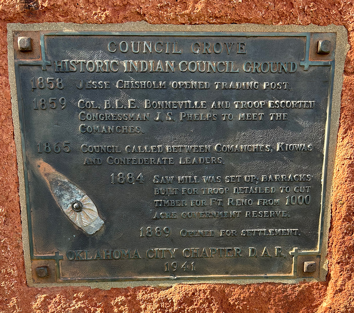
Jesse Chisholm opened a trading post in Council Grove in 1858. Col. Bonneville escorted Congressman J. S. Phelps through Council Grove to meet with the Comanche in 1859. In 1865 Comanche and Kiowa met with Confederate leaders. Barracks were constructed on site to house soldiers to clear timber for the construction of Fort Reno in 1884. Council Grove opened to settlement in 1889.
View image

View image
Council Grove
Oklahoma CountyLocation: 820 North MacArthur Boulevard in Oklahoma City
Coordinates: 35.475143, -97.618764
Material: Aluminum
Sponsor(s): WesTen District and the Oklahoma Historical Society
Topics: American Indians; Environmental/Cultural Ecology; Indian and Frontier Trade; Military; Ranching; Settlement Patterns; Territorial Period, 1861–1907; Westward Expansion, 1803–1861
Council Grove was heavily wooded with cottonwood and elm trees, creating an ideal meeting place for the Muscogee (Creek), Kiowa, and Comanche nations. Jesse Chisholm, a trader of Scottish and Cherokee descent, opened a trading post in Council Grove in 1858. Chisholm encouraged cattle rancher Montford T. Johnson (Chickasaw) to establish a ranch in the area. Vicey Hermon (or Harmon, Chickasaw) managed the ranch, also known as “Johnson’s Grove,” which became known as the first permanent settlement in present Oklahoma City. In 1874 the federal government established a military reservation within Council Grove to provide wood for the construction of Fort Reno. David Payne established a boomer camp in Council Grove in 1880. In 1885, William Couch announced his intentions to colonize present Oklahoma County near Johnson’s ranch, only to be removed by the US cavalry. All of Council Grove except for the military reservation was opened to settlement on April 22, 1889. The Council Grove military reservation opened to settlement in December 1899.

View image
Council Grove
Oklahoma CountyLocation: in Melrose Park in Oklahoma City
Coordinates: 35.471460, -97.651433
Material: Granite
Sponsor(s): Oklahoma Historical Society
Topics: Land Openings; Military; Territorial Period, 1861–1907
During the opening of the Unassigned Lands in 1889, several sections of land in Council Grove were closed to settlement. Wood from these sections was reserved for use by Fort Reno and was guarded by the US Cavalry. Once the fort had no more use for timber in the reserve, it was auctioned for settlement in 1899. One of the first schools in Oklahoma County was established near this marker’s location. A post office was established in June 1892 and operated until 1906.

View image
Council Grove School
Oklahoma CountyLocation: on grounds of Council Grove Elementary School, 7721 Melrose Lane, in Oklahoma City
Coordinates: 35.472130, -97.653110
Material: Other
Sponsor(s): Unknown
Topics: Early Statehood, 1907–1941; Education; Industrial Period, 1941–1982; Territorial Period, 1861–1907
One of the first schools in Oklahoma County was originally located on West Reno Avenue. It was later moved to the southeast corner of Melrose Lane and Council Road. A second school building was constructed in 1900. It was replaced by a brick structure in 1938. In 1959 the Council Grove School District joined with four other school districts to form the Western Heights Public School District. A new structure was built in 1962 to serve as an elementary school for the district. The present elementary school building was constructed in 2011.

View image
(Page 1 of 1)
Marker Search
Use quotation marks to search for an exact phrase.
Browse by County
Adair County
Alfalfa County
Atoka County
Beaver County
Beckham County
Blaine County
Bryan County
Caddo County
Canadian County
Carter County
Cherokee County
Choctaw County
Cimarron County
Cleveland County
Comanche County
Cotton County
Craig County
Creek County
Custer County
Delaware County
Dewey County
Ellis County
Garfield County
Garvin County
Grady County
Grant County
Greer County
Harmon County
Harper County
Haskell County
Hughes County
Jackson County
Jefferson County
Johnston County
Kay County
Kingfisher County
Kiowa County
Latimer County
Le Flore County
Lincoln County
Logan County
Love County
Major County
Marshall County
Mayes County
McClain County
McCurtain County
McIntosh County
Murray County
Muskogee County
Noble County
Nowata County
Okfuskee County
Oklahoma County
Okmulgee County
Osage County
Ottawa County
Pawnee County
Payne County
Pittsburg County
Pontotoc County
Pottawatomie County
Pushmataha County
Roger Mills County
Rogers County
Seminole County
Sequoyah County
Stephens County
Texas County
Tillman County
Tulsa County
Wagoner County
Washington County
Washita County
Woods County
Woodward County
Alfalfa County
Atoka County
Beaver County
Beckham County
Blaine County
Bryan County
Caddo County
Canadian County
Carter County
Cherokee County
Choctaw County
Cimarron County
Cleveland County
Comanche County
Cotton County
Craig County
Creek County
Custer County
Delaware County
Dewey County
Ellis County
Garfield County
Garvin County
Grady County
Grant County
Greer County
Harmon County
Harper County
Haskell County
Hughes County
Jackson County
Jefferson County
Johnston County
Kay County
Kingfisher County
Kiowa County
Latimer County
Le Flore County
Lincoln County
Logan County
Love County
Major County
Marshall County
Mayes County
McClain County
McCurtain County
McIntosh County
Murray County
Muskogee County
Noble County
Nowata County
Okfuskee County
Oklahoma County
Okmulgee County
Osage County
Ottawa County
Pawnee County
Payne County
Pittsburg County
Pontotoc County
Pottawatomie County
Pushmataha County
Roger Mills County
Rogers County
Seminole County
Sequoyah County
Stephens County
Texas County
Tillman County
Tulsa County
Wagoner County
Washington County
Washita County
Woods County
Woodward County
To find out more about the Oklahoma Historical Society Historical Marker Program or how to submit an application, please visit the Historical Marker Program page.
Missing or Damaged Markers
Please use our online form to report missing or damaged historical markers.
Report Missing or Damaged Markers
Contact Us
If you have questions, please contact:
Matthew Pearce
Oklahoma Historical Society
800 Nazih Zuhdi Drive
Oklahoma City, OK 73105
405-522-8659
[email protected]
