
Home | About OHS | Historical Marker Program
Location: on OK-78, one and a half miles south of Achille
Material: Granite
Note: Marker reported damaged
Topics: American Indians, Religion/Philosophy, Government, Westward Expansion 1803–1861, Education
Bloomfield Academy, a seminary for Chickasaw girls, was established in 1853 by authority of the Methodist Missionary Board. The school was located on two different sites in Bryan County before it was moved to Ardmore in 1917. There it was renamed Carter Seminary in honor of Congressman Charles D. Carter.
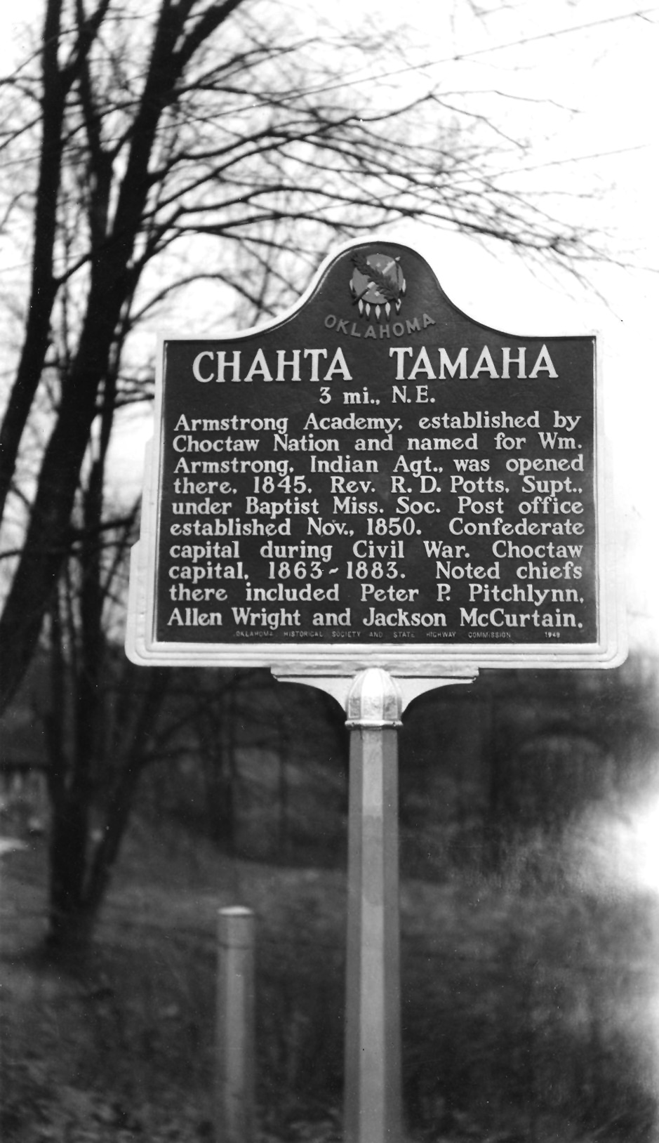
Location: on US-70 at the eastern city limits of Bokchito
Material: Aluminum
Topics: American Indians, Westward Expansion 1803–1861, Territorial Period 1861–1907, Government, Education
This settlement was also called Choctaw City and was the site of Armstrong Academy, established by the Choctaw Nation in 1845. The Choctaw National Council met in the main hall of the academy for twenty years. Chahte Tamaha served as the Confederate capital during the Civil War. Delegates to a meeting of the United Nations of Indian Territory met here at the beginning of the Civil War to ally with the Confederacy. Armstrong Academy continued as a Choctaw boys school until a fire destroyed the building in 1919.
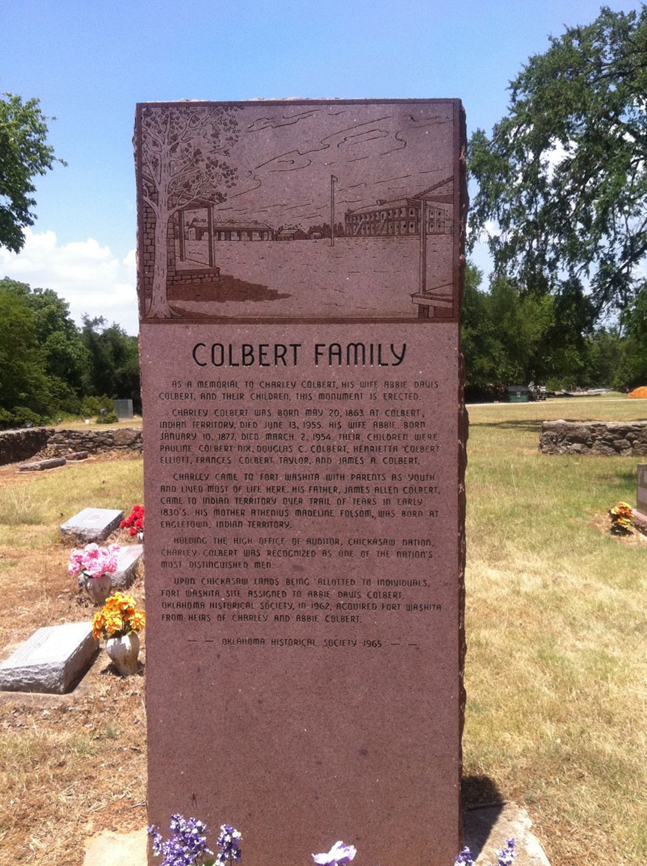
Location: on OK-199, thirteen miles east of Madill in Fort Washita Cemetery
Material: Granite
Topics: American Indians, Government
For 200 years, some of the most famous tribal leaders of the Chickasaw Nation came from this family. Their leadership abilities were well-known and utilized during negotiations with the federal government. The marker is a tribute to Charley Colbert, auditor of the Chickasaw Nation.
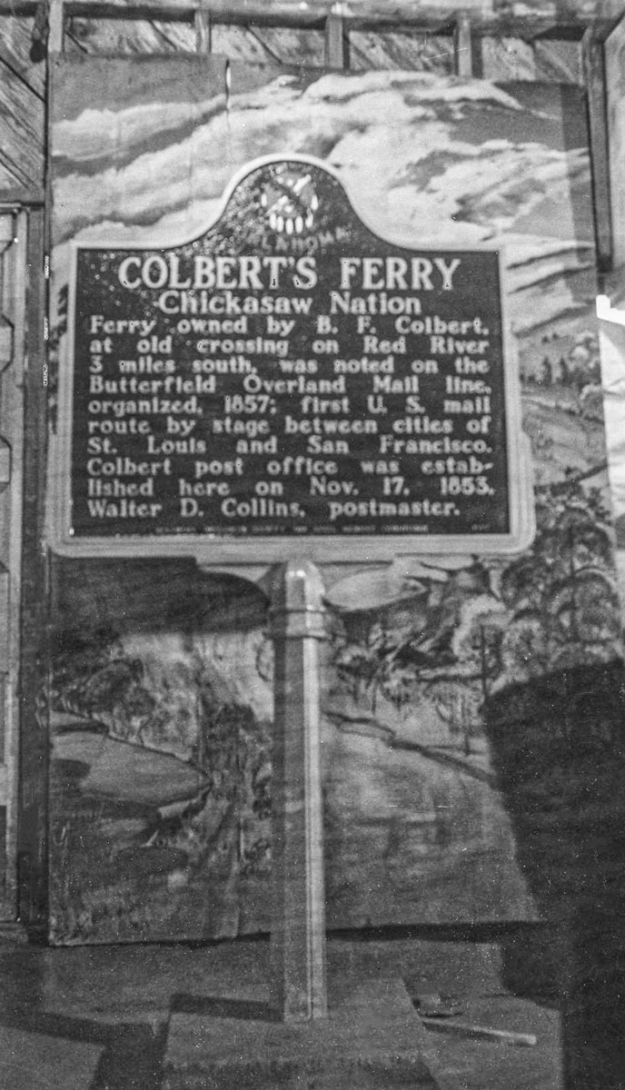
Location: on US-69 in Colbert
Topics: Transportation, American Indians, Government, Social/Cultural, Westward Expansion 1803–1861
Colbert's Ferry was located on the Red River about three-fourths of a mile from the home of Benjamin F. Colbert. Colbert owned the ferry that provided travelers with a safe journey across the river. Colbert's home served as a stop on the Butterfield Mail Route from 1858 to the early days of the Civil War. The Colbert post office was established here on November 17, 1853.
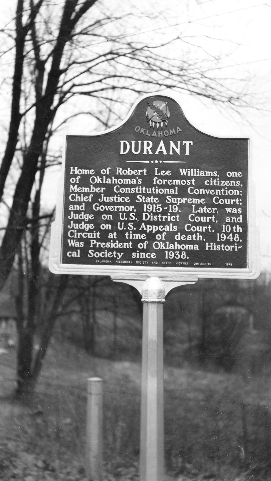
Location: on US-69 on north side of Durant
Topics: American Indians, Government, Territorial Period 1861–1907, Early Statehood 1907–1941
The town of Durant was named for Dixon Durant, member of a prominent Choctaw-French family in the Choctaw Nation. The first Durant post office was established on February 20, 1879. Durant was home to one of the state's greatest leaders, Robert Lee Williams, a member of the constitutional convention, chief justice of the Oklahoma Supreme Court, governor of Oklahoma, a federal district judge, and judge of the Tenth Circuit Court of Appeals.
Location: two miles south of US-70, four miles west of Durant
Material: Granite
Topics: Social/Cultural, Transportation, Government, Social/Cultural
In 1857, Congress created the Butterfield Overland Mail Route to carry mail and passengers between St. Louis, Missouri, and Memphis, Tennessee, and points west. It was the first real transcontinental link between the Atlantic states and the Pacific Coast of the United States. There were twelve stations along a 197-mile route in Oklahoma, including Fisher's.
Location: on OK-48 west of Kenefic
Material: Aluminum
Note: Marker reported missing
Topics: Government, Military, Territorial Period 1861–1907
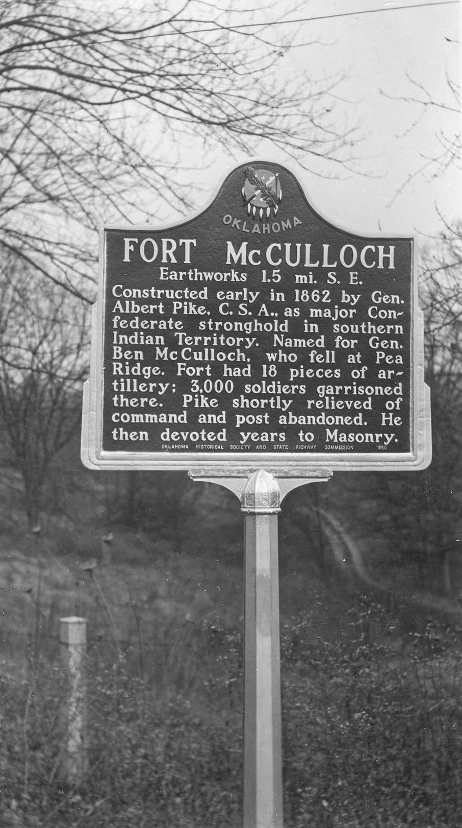
Brigadier General Albert Pike built Fort McCulloch in 1862 as a major Confederate stronghold in Indian Territory. The post was named for Brigadier General Ben McCullough who was killed in the Battle of Pea Ridge. During the Civil War, the fort was home to 3,000 soldiers and eighteen pieces of artillery. The post was abandoned soon after Pike was relieved of his command in the fall of 1862.
Location: on OK-199 east of Lake Texoma bridge, thirteen miles east of Madill
Material: Originally aluminum, now granite
Topics: Military, Government, Territorial Period 1861–1907
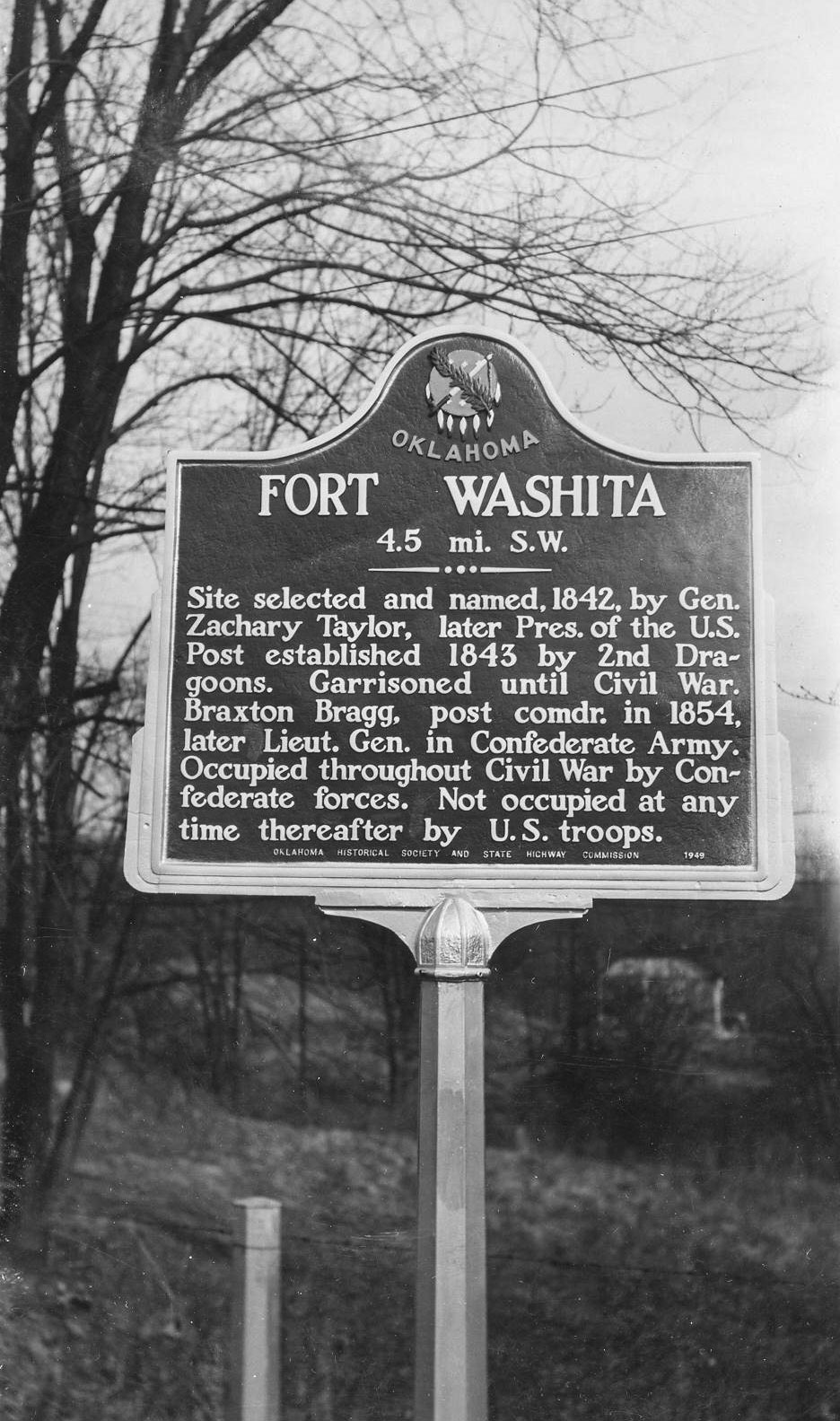
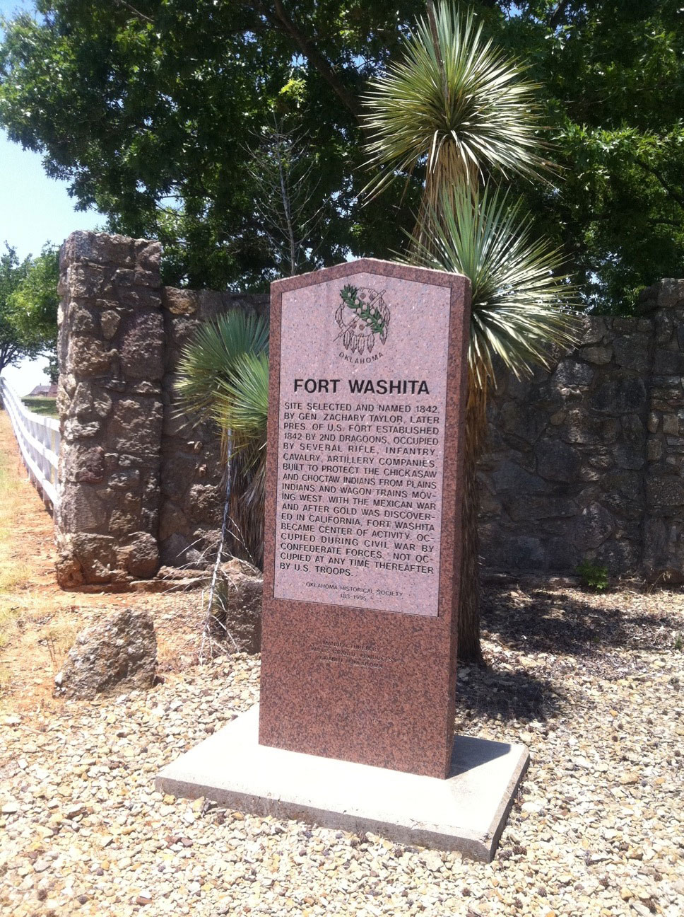
The site for Fort Washita was selected by the post's first commander, and later President of the United States, Zachary Taylor. US Army troops manned the fort from April 23, 1843, until it was abandoned to Confederate forces on May 1, 1861. After the Civil War, the fort was never again used as a military installation, but the post office remained open until May 1880.
Location: on OK-199, thirteen miles east of Madill in Fort Washita Cemetery
Material: Granite
Topics: American Indians, Government, Military, Westward Expansion 1803–1861, Territorial Period 1861–1907
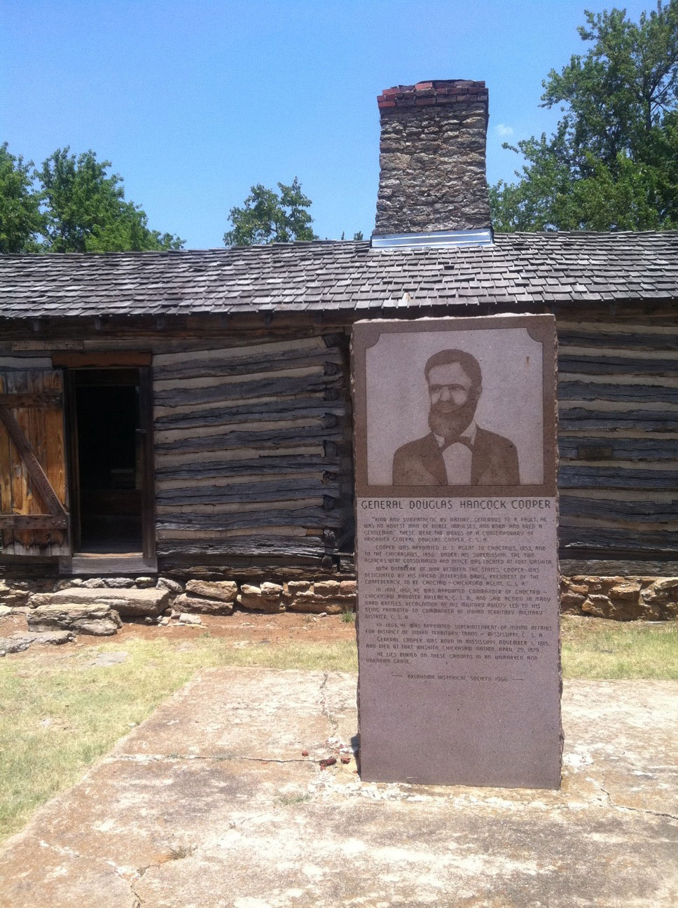
General Cooper was appointed as the US Indian agent to the Choctaws in 1853 and to the Chickasaws in 1856. He consolidated the two agencies and moved them to Fort Washita. When the Civil War began, Cooper's friend, Confederate President Jefferson Davis, appointed him Choctaw-Chickasaw agent for the Confederacy. As commander of the Choctaw-Chickasaw Confederate mounted riflemen, he saw much action. He later was promoted to commander of the Indian Territory Military District, C.S.A., and was named Superintendent of Indian Affairs by President Davis. He died at Fort Washita in 1879 and is buried in an unmarked grave.
Location: near Douglas Cooper monument at Fort Washita
Material: Granite
Topics: American Indians, Social/Cultural, Territorial Period 1861–1907, Military
Sponsored by the Julia Jackson Chapter of the United Daughters of the Confederacy, the nearby granite marker honors Douglas Hancock Cooper, the first Confederate agent for the Choctaws and Chickasaws and later commander of the Choctaw-Chickasaw Mounted Rifles.
Location: on east side of Blue River two miles southwest of Kenefic
Topics: Transportation, Government, Social/Cultural
Nail's Crossing was a stage stand of the Butterfield Overland Mail Route. See Fisher's Station.
Location: at entrance to Pioneer Cemetery in Durant
Sponsored by: Daughters of the American Revolution
Topics: Social/Cultural, American Indians, Westward Expansion 1803–1861, Government
The Pioneer Cemetery was first used as a burial plot for family members of Fisher Durant, who settled the area following removal of the Choctaws from Mississippi in 1834. Also in the cemetery is the grave of Dixon D. Durant, founder of the town of Durant.
Le Flore County
Lincoln County
Logan County
Love County
Marshall County
Mayes County
McClain County
McCurtain County
McIntosh County
Murray County
Muskogee County
Noble County
Okfuskee County
Oklahoma County
Okmulgee County
Osage County
Ottawa County
Pawnee County
Payne County
Pittsburg County
Pontotoc County
Pottawatomie County
Pushmataha County
Roger Mills County
Rogers County
Seminole County
Sequoyah County
Stephens County
Texas County
Tillman County
Tulsa County
Wagoner County
Washington County
Washita County
Woods County
Woodward County
Historical Marker Program
Search Results
Your search returned 12 results.
Bloomfield Academy
Bryan CountyLocation: on OK-78, one and a half miles south of Achille
Material: Granite
Note: Marker reported damaged
Topics: American Indians, Religion/Philosophy, Government, Westward Expansion 1803–1861, Education
Bloomfield Academy, a seminary for Chickasaw girls, was established in 1853 by authority of the Methodist Missionary Board. The school was located on two different sites in Bryan County before it was moved to Ardmore in 1917. There it was renamed Carter Seminary in honor of Congressman Charles D. Carter.
Chahte Tamaha
Bryan CountyLocation: on US-70 at the eastern city limits of Bokchito
Material: Aluminum
Topics: American Indians, Westward Expansion 1803–1861, Territorial Period 1861–1907, Government, Education
This settlement was also called Choctaw City and was the site of Armstrong Academy, established by the Choctaw Nation in 1845. The Choctaw National Council met in the main hall of the academy for twenty years. Chahte Tamaha served as the Confederate capital during the Civil War. Delegates to a meeting of the United Nations of Indian Territory met here at the beginning of the Civil War to ally with the Confederacy. Armstrong Academy continued as a Choctaw boys school until a fire destroyed the building in 1919.
Colbert Family
Bryan CountyLocation: on OK-199, thirteen miles east of Madill in Fort Washita Cemetery
Material: Granite
Topics: American Indians, Government
For 200 years, some of the most famous tribal leaders of the Chickasaw Nation came from this family. Their leadership abilities were well-known and utilized during negotiations with the federal government. The marker is a tribute to Charley Colbert, auditor of the Chickasaw Nation.
Colbert's Ferry
Bryan CountyLocation: on US-69 in Colbert
Topics: Transportation, American Indians, Government, Social/Cultural, Westward Expansion 1803–1861
Colbert's Ferry was located on the Red River about three-fourths of a mile from the home of Benjamin F. Colbert. Colbert owned the ferry that provided travelers with a safe journey across the river. Colbert's home served as a stop on the Butterfield Mail Route from 1858 to the early days of the Civil War. The Colbert post office was established here on November 17, 1853.
Durant
Bryan CountyLocation: on US-69 on north side of Durant
Topics: American Indians, Government, Territorial Period 1861–1907, Early Statehood 1907–1941
The town of Durant was named for Dixon Durant, member of a prominent Choctaw-French family in the Choctaw Nation. The first Durant post office was established on February 20, 1879. Durant was home to one of the state's greatest leaders, Robert Lee Williams, a member of the constitutional convention, chief justice of the Oklahoma Supreme Court, governor of Oklahoma, a federal district judge, and judge of the Tenth Circuit Court of Appeals.
Fisher's Station
Bryan CountyLocation: two miles south of US-70, four miles west of Durant
Material: Granite
Topics: Social/Cultural, Transportation, Government, Social/Cultural
In 1857, Congress created the Butterfield Overland Mail Route to carry mail and passengers between St. Louis, Missouri, and Memphis, Tennessee, and points west. It was the first real transcontinental link between the Atlantic states and the Pacific Coast of the United States. There were twelve stations along a 197-mile route in Oklahoma, including Fisher's.
Fort McCulloch
Bryan CountyLocation: on OK-48 west of Kenefic
Material: Aluminum
Note: Marker reported missing
Topics: Government, Military, Territorial Period 1861–1907
Brigadier General Albert Pike built Fort McCulloch in 1862 as a major Confederate stronghold in Indian Territory. The post was named for Brigadier General Ben McCullough who was killed in the Battle of Pea Ridge. During the Civil War, the fort was home to 3,000 soldiers and eighteen pieces of artillery. The post was abandoned soon after Pike was relieved of his command in the fall of 1862.
Fort Washita
Bryan CountyLocation: on OK-199 east of Lake Texoma bridge, thirteen miles east of Madill
Material: Originally aluminum, now granite
Topics: Military, Government, Territorial Period 1861–1907
The site for Fort Washita was selected by the post's first commander, and later President of the United States, Zachary Taylor. US Army troops manned the fort from April 23, 1843, until it was abandoned to Confederate forces on May 1, 1861. After the Civil War, the fort was never again used as a military installation, but the post office remained open until May 1880.
General Douglas Hancock Cooper
Bryan CountyLocation: on OK-199, thirteen miles east of Madill in Fort Washita Cemetery
Material: Granite
Topics: American Indians, Government, Military, Westward Expansion 1803–1861, Territorial Period 1861–1907
General Cooper was appointed as the US Indian agent to the Choctaws in 1853 and to the Chickasaws in 1856. He consolidated the two agencies and moved them to Fort Washita. When the Civil War began, Cooper's friend, Confederate President Jefferson Davis, appointed him Choctaw-Chickasaw agent for the Confederacy. As commander of the Choctaw-Chickasaw Confederate mounted riflemen, he saw much action. He later was promoted to commander of the Indian Territory Military District, C.S.A., and was named Superintendent of Indian Affairs by President Davis. He died at Fort Washita in 1879 and is buried in an unmarked grave.
Julia Jackson Chapter United Daughters of the Confederacy
Bryan CountyLocation: near Douglas Cooper monument at Fort Washita
Material: Granite
Topics: American Indians, Social/Cultural, Territorial Period 1861–1907, Military
Sponsored by the Julia Jackson Chapter of the United Daughters of the Confederacy, the nearby granite marker honors Douglas Hancock Cooper, the first Confederate agent for the Choctaws and Chickasaws and later commander of the Choctaw-Chickasaw Mounted Rifles.
Nail's Crossing
Bryan CountyLocation: on east side of Blue River two miles southwest of Kenefic
Topics: Transportation, Government, Social/Cultural
Nail's Crossing was a stage stand of the Butterfield Overland Mail Route. See Fisher's Station.
Pioneer Cemetery
Bryan CountyLocation: at entrance to Pioneer Cemetery in Durant
Sponsored by: Daughters of the American Revolution
Topics: Social/Cultural, American Indians, Westward Expansion 1803–1861, Government
The Pioneer Cemetery was first used as a burial plot for family members of Fisher Durant, who settled the area following removal of the Choctaws from Mississippi in 1834. Also in the cemetery is the grave of Dixon D. Durant, founder of the town of Durant.
(Page 1 of 1)
Search for Markers
Search by keyword or browse by county to learn about more than 600 historical markers created to recognize key locations, events, and people in Oklahoma history.
Please note that some markers listed in this database may have been moved, damaged, or are no longer standing.
Browse by County
Adair County
Alfalfa County
Atoka County
Beaver County
Beckham County
Blaine County
Bryan County
Caddo County
Canadian County
Carter County
Cherokee County
Choctaw County
Cimarron County
Cleveland County
Comanche County
Cotton County
Craig County
Creek County
Custer County
Delaware County
Dewey County
Ellis County
Garfield County
Garvin County
Grady County
Grant County
Greer County
Harmon County
Harper County
Haskell County
Hughes County
Jackson County
Jefferson County
Johnston County
Kay County
Kingfisher County
Kiowa County
Latimer CountyAlfalfa County
Atoka County
Beaver County
Beckham County
Blaine County
Bryan County
Caddo County
Canadian County
Carter County
Cherokee County
Choctaw County
Cimarron County
Cleveland County
Comanche County
Cotton County
Craig County
Creek County
Custer County
Delaware County
Dewey County
Ellis County
Garfield County
Garvin County
Grady County
Grant County
Greer County
Harmon County
Harper County
Haskell County
Hughes County
Jackson County
Jefferson County
Johnston County
Kay County
Kingfisher County
Kiowa County
Le Flore County
Lincoln County
Logan County
Love County
Marshall County
Mayes County
McClain County
McCurtain County
McIntosh County
Murray County
Muskogee County
Noble County
Okfuskee County
Oklahoma County
Okmulgee County
Osage County
Ottawa County
Pawnee County
Payne County
Pittsburg County
Pontotoc County
Pottawatomie County
Pushmataha County
Roger Mills County
Rogers County
Seminole County
Sequoyah County
Stephens County
Texas County
Tillman County
Tulsa County
Wagoner County
Washington County
Washita County
Woods County
Woodward County
Contact Us
If you have questions, please contact:
Matthew Pearce
Oklahoma Historical Society
800 Nazih Zuhdi Drive
Oklahoma City, OK 73105
405-522-8659
matthew.pearce@history.ok.gov