
Home | About OHS | Historical Marker Program
Location: on OK-11 at 86th Street North in Tulsa
Topics: Military, American Indians, Territorial Period 1861–1907, Government
This battle was the second in a series of three engagements between pro-Northern Indians led by Opothleyahola and a combined white and Indian Confederate force on December 9, 1861, on Bird Creek.
Location: at junction of OK-51 and Old Dawson Road south of old Keystone
Topics: Military, Territorial Period 1861–1907, Government
The first Civil War battle in Oklahoma was fought here on November 19, 1861, between Confederate troops led by Colonel Douglas H. Cooper and Union forces led by Creek Chief Opothleyahola. The Southerners prevailed and occupied the Confederate encampment nearby. Some scholars believe this battle occurred in Payne County.
Location: on south edge of OSU-Tulsa campus
Material: Granite
Topics: Education, Ethnic Diversity, Civil Rights, Early Statehood 1907–1941
The original school for African American students in Tulsa was a four-room wood building constructed in 1913. In 1919, a brick building was built on the same site and was one of the few structures to survive the 1921 Race Riot. The school moved to its present site in 1950.
Location: north of Eighteenth Street at South Cheyenne Avenue in Tulsa
Sponsored by: Tulsa County Historical Society
Topics: Social/Cultural, Natural Resources, Settlement Patterns
Under this great oak tree in 1828, the Creeks deposited the embers of a fire they had carried from their homeland in Alabama and kindled a new fire in their new home. It was the beginning of a village named Tulseytown, now the city of Tulsa.
Location: east side of US-75, 300 feet south of 141st Street in Tulsa
Material: Granite
Topics: Industry/Business, Petroleum, Natural Resources, Transportation, Early Statehood 1907–1941
The beginning of Oklahoma's famous oil boom brought the need for processing facilities located near the source of the raw material. Kiefer, Oklahoma, the closest unloading point on the Frisco Railroad to the newly opened oil fields, was the site selected for the first casing-head gas-treating plant which extracted gasoline from wet gas, west of the Mississippi River. The location of the plant in this region was a tremendous boost to the infant, but thriving oil industry in Oklahoma.
Location: on West Eleventh Street, between Jackson and Lawton streets, in Tulsa
Topics: Social/Cultural, Recreational/Service, Territorial Period 1861–1907
The site is two blocks north. Tulsa's first chartered Hospital and Training School for Nurses was organized on November 20, 1906. It was headed by Fred S. Clinton, M.D., president; C. L. Reeder, M.D., secretary; C. Z. Wiley, M.D., treasurer; and H. C. C. Ziegler, R.N., superintendent of nurses. It safeguarded health in a wide area of Indian Territory.
Location: on 66 at the north side of Red Fork
Topics: American Indians, Settlement Patterns, Petroleum, Natural Resources, Industrial Period 1841–1892
This well about a half-mile west of the marker was on the Creek allotment of Dr. Bland's wife and was in production with oil royalties, paying the Bland heirs until the well was closed down around 1952.
Location: in Brush Creek Park near Sand Springs
Sponsored by: Tulsa County Historical Society
Topics: Military, American Indians, Westward Expansion 1803–1861
The site of Fort Arbuckle is less than one mile north. One of the two US military posts on the western frontier of the Creek Nation, this "first" Fort Arbuckle in Indian Territory was built in 1834 by troops of the 7th Infantry with Major George Birch in command. The stockade buildings were garrisoned only a few months.
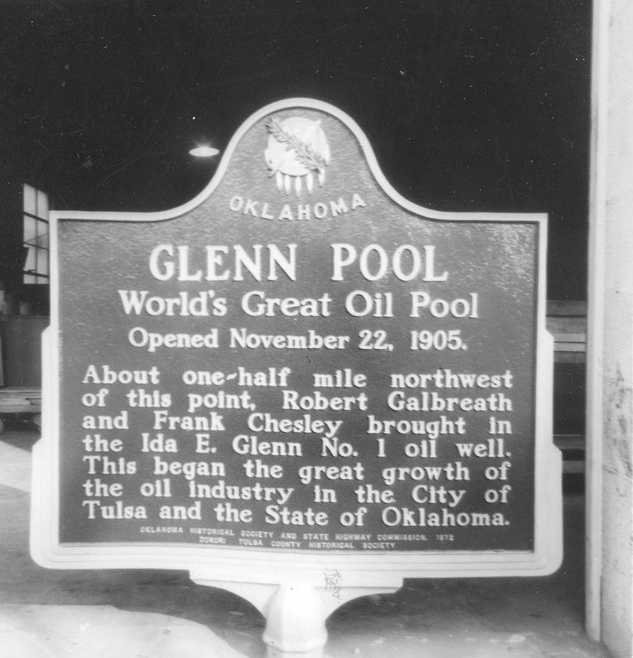
Location: at the town of Glenpool, Tulsa County on the east side of US-75 at junction with SH-67.
Topics: Territorial Period 1861–1907, Petroleum, Industry/Business, Natural Resources
Glenn Pool opened on November 22, 1905. About one-half mile northwest of this point, Robert Galbreath and Frank Chesley brought in the Ida E. Glenn No. 1 Oil Well. This began the great growth of the oil industry in the city of Tulsa and the state of Oklahoma.
Location: on OK-11, four miles north of Skiatook
Material: Aluminum
Topics: Religion/Philosophy, Social/Cultural, American Indians, Environmental/Cultural Ecology, Territorial Period 1861–1907
Reverend John Murdock established the Hillside Mission school in 1882 under the auspices of the Society of Friends. A nearby cemetery contains the grave of William C. Rogers, the last elected principal chief of the Cherokees prior to statehood.
Location: on Keystone Expressway (US-64) at the intersection of 45th West Avenue in Tulsa
Topics: Religion/Philosophy, Social/Cultural, American Indians, Environmental/Cultural Ecology, Territorial Period 1861–1907
Holmes Peak is the only geographical feature on Earth officially named by a government in honor of Sherlock Holmes. The US Board on Geographic Names approved the name on October 24, 1984. Another officially named geographic feature to honor Holmes is a crater on the Moon named by Astronaut Harrison Schmidt on the Apollo 17 Moon Landing.
Location: at entrance of Owen Park on West Edison Street in Tulsa (DAR)
Sponsored by: Daughters of the American Revolution
Topics: Government, American Indians
This is the spot where the Creek, Cherokee, and Osage national boundaries joined.
-001.jpg)
Location: on Tulsa State Fair Grounds
Material: Granite
Topics: Arts, Petroleum, Urban Development, Folklife, Natural Resources, Early Statehood 1907–1941
The huge Golden Driller honors the founding of the international showcase of the oil industry. During Tulsa's heyday as "Oil capital of the world," the annual exposition drew oil field exhibitors from around the world.
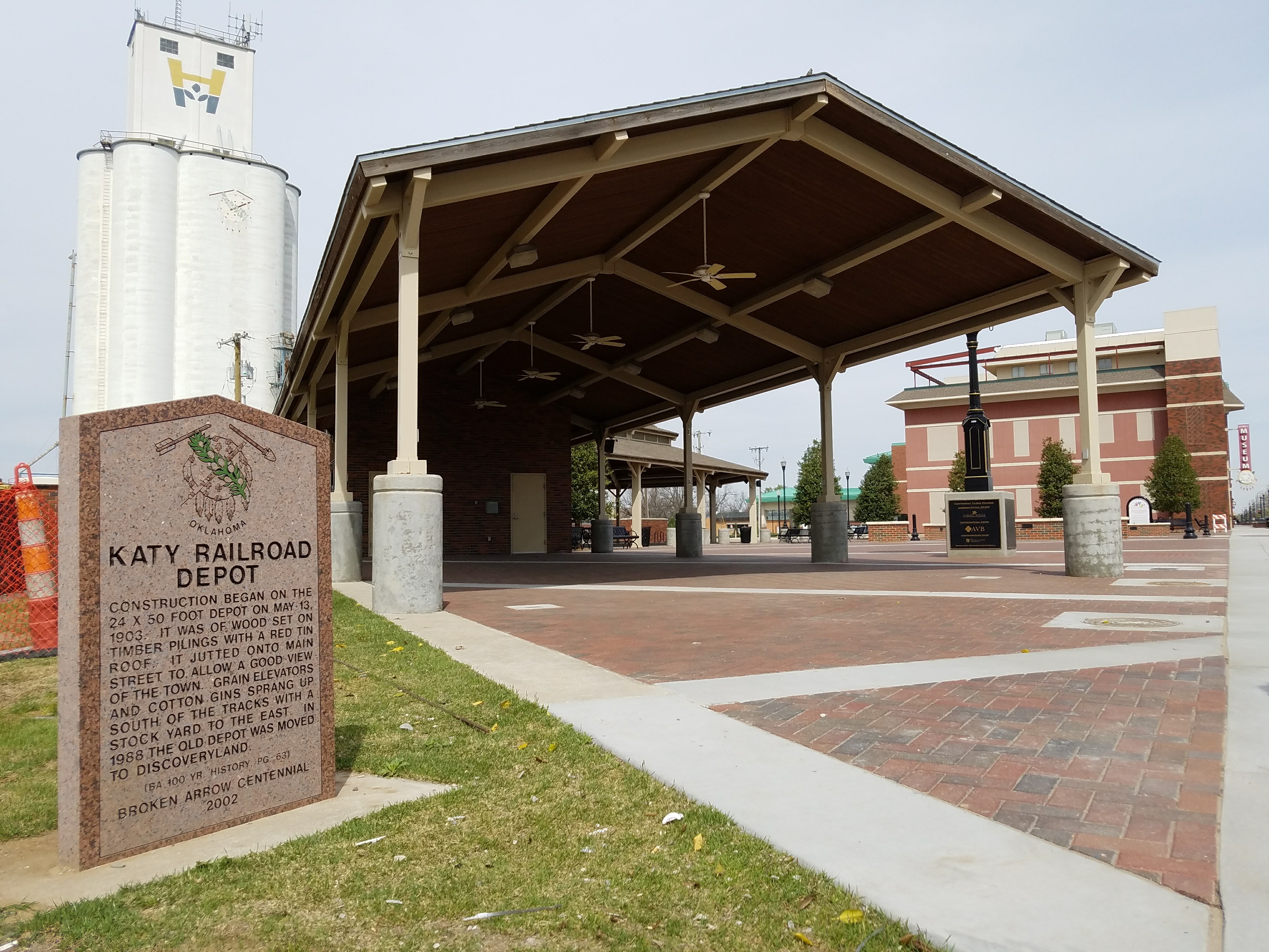
Location: On south Main Street in Broken Arrow
Coordinates: 36.048503, -95.790847
Material: Granite
Topics: Transportation
Construction began on the 24 x 50 foot depot on May 13, 1903. It was of wood set on timber pilings with a red tin roof. It jutted onto Main Street to allow a good view of the town. Grain elevators and cotton gins sprang up south of the tracks with a stockyard to the east. In 1988 the old depot was moved to Discoveryland. (BA. 100 yr. history, pg 63_ Broken Arrow Centennial 2002.
Location: 419 North Elgin Avenue, Tulsa
Topics: Religion/Philosophy
Mt. Zion Baptist Church was organized in 1909 in a one-room frame school building located in the 300 block of North Hartford under the Revered Sandy Lyons. Church Founders included Mr. Aaron Ellis, Mrs. Kate Bell Baldridge, Reverend Alexander Brown, Mrs. Georgia Brown, Mrs. Cornelia Dallas, Mrs. Mary A. Grayson, Mrs. Hannah Hale, Mr. Jim Hale, Mrs. Ella Bell Johnson, Mrs. Caroline Lollis, Mrs. Ella Suggs, Mrs. Ida Rector, Mrs. Jeanette E. Webb and Mrs. Nellie Brown Wharton. Soon after Reverend R.A. Whitaker assumed the pulpit at Mt. Zion, the congregation was forced to move from the school building with only three days notice. Hardships, discouragement and disappointment would not deter the congregation and a permanent church home was erected at 419 North Elgin.The first service was held in the new $92,000 church on April 4, 1921. Nearly one month later, the imposing structure of Mount Zion was reduced to ashes during the Tulsa Race Riot on June 1, 1921. It took twenty-one years, until November 23, 1942, for the original mortgage of $50,000 to be retired. Reverend J. H. Dotson immediately started a Building Fund for a new church. W. S. and J. C. Latimer were architects and members of Mount Zion. Graduating from Booker T. Washington's famed Tuskegee Institute, the two brothers completed the drawings and plans for the new church. Bit by bit, Mt. Zion's members paid for rebuilding the basement of the old church and a new church. On Sunday, October 21, 1952, dedication services were held in "The Church That Faith Built." Nearly one year later, Rev. Dotson's health began to fail and the Reverend G. Calvin McCutchen accepted the leadership of Mt. Zion. Dr. McCutchen, serving longer than any other pastor, led the church in paying off the mortgage of the church. Under his leadership numerous improvements have been made including a nursery, the J. H. Dotson Memorial Scholarship Fund was established for Mt. Zion college students, and the addition of a multi-purpose facility known as the Family Life Center. The Center was renamed to the G. Calvin McCutchen Sr. Family Life Center in honor of Dr. McCutchen in 1998.
Location: in Municipal Plaza in downtown Tulsa
Material: Granite
Tulsa has long been known as the Oil Capital of the World and the City That Oil Built. The rise of Tulsa to a place of preeminence in the petroleum industry began on June 25, 1901, when a well was brought in at Red Fork across the Arkansas River to the southwest. Tulsa leaders caused a bridge to be built between the two points and national publicity focused attention on Tulsa as a center of a new oil region. "When a major oil strike took place at the nearby Glenn Pool on Nov. 22, 1905, the production of oil in the area became so great that the term "Oil Capital of the World" was universally applied to Tulsa. Other fields were discovered and developed in adjacent areas to a point where, for a time, it was the largest oil producing center on earth. Tulsa remained in the forefront of exploration and development, financing, equipment manufacturing and provided skills and executive direction for a growing worldwide industry--hence it continued to hold the title: Oil Capital of the World.
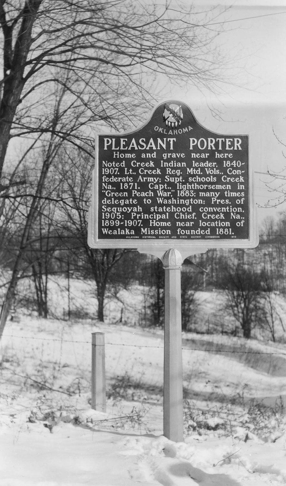
Location: on US-64, at village of Leonard, about nine miles east of Bixby, Tulsa County
Topics: American Indians, Military, Government, Territorial Period 1861–1907, Religion/Philosophy
The home and grave near here are of the noted Creek leader, Pleasant Porter (1840–1907). Lt. Creek Reg. Mtd. Vols., Confederate Army; Porter was superintendent of schools in the Creek Nation, 1871; Captain of the lighthorsemen in the "Green Peach War," 1883; a delegate to Washington; president of the Sequoyah Statehood Convention, 1905; and Principal Chief of the Creek Nation, 1899-1907. His home was near the location of Woalaka Mission founded in 1881.
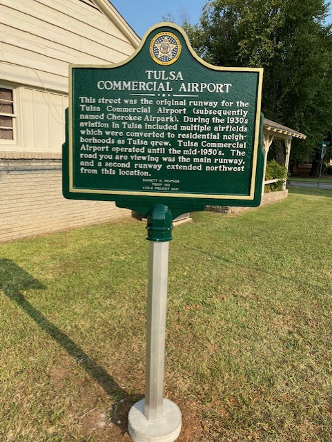
Location: 6060 American Plaza in Tulsa
Topics: Transportation
This street was the original runway for the Tulsa Commercial Airport (subsequently named Cherokee Airpark). During the 1930s aviation in Tulsa included multiple airfields which were converted to residential neighborhoods as Tulsa grew. Tulsa Commercial Airport operated until the mid-1950s. The road you are viewing was the main runway, and a second runway extended northwest from this location.
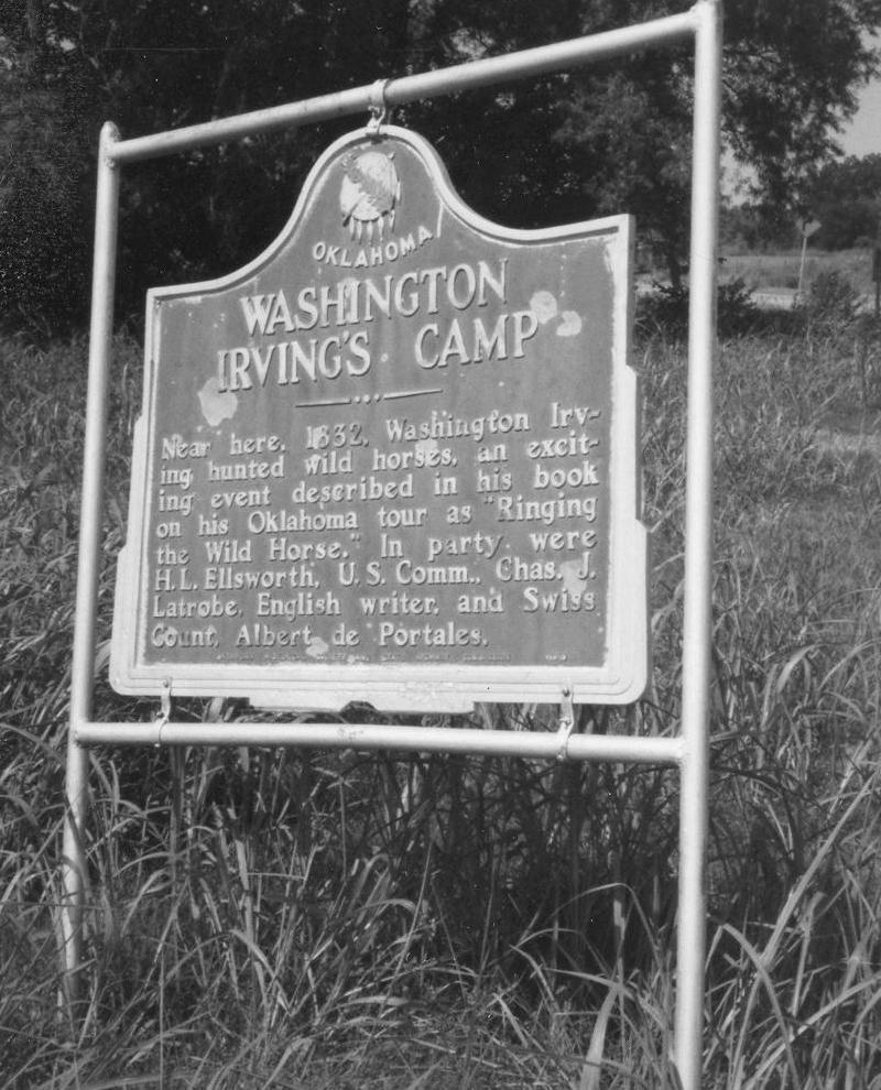
Location: at West Easton Avenue and North Vancouver Street in Tulsa
Topics: Arts, Westward Expansion 1803–1861, Transportation
Washington Irving traveled through Tulsa County in 1832 during his tour of the prairies.
Le Flore County
Lincoln County
Logan County
Love County
Marshall County
Mayes County
McClain County
McCurtain County
McIntosh County
Murray County
Muskogee County
Noble County
Okfuskee County
Oklahoma County
Okmulgee County
Osage County
Ottawa County
Pawnee County
Payne County
Pittsburg County
Pontotoc County
Pottawatomie County
Pushmataha County
Roger Mills County
Rogers County
Seminole County
Sequoyah County
Stephens County
Texas County
Tillman County
Tulsa County
Wagoner County
Washington County
Washita County
Woods County
Woodward County
Historical Marker Program
Search Results
Your search returned 19 results.
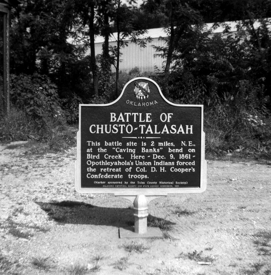
Battle of Chusto-Talasah
Tulsa CountyLocation: on OK-11 at 86th Street North in Tulsa
Topics: Military, American Indians, Territorial Period 1861–1907, Government
This battle was the second in a series of three engagements between pro-Northern Indians led by Opothleyahola and a combined white and Indian Confederate force on December 9, 1861, on Bird Creek.
Battle of Round Mountain
Tulsa CountyLocation: at junction of OK-51 and Old Dawson Road south of old Keystone
Topics: Military, Territorial Period 1861–1907, Government
The first Civil War battle in Oklahoma was fought here on November 19, 1861, between Confederate troops led by Colonel Douglas H. Cooper and Union forces led by Creek Chief Opothleyahola. The Southerners prevailed and occupied the Confederate encampment nearby. Some scholars believe this battle occurred in Payne County.
Booker T. Washington High School
Tulsa CountyLocation: on south edge of OSU-Tulsa campus
Material: Granite
Topics: Education, Ethnic Diversity, Civil Rights, Early Statehood 1907–1941
The original school for African American students in Tulsa was a four-room wood building constructed in 1913. In 1919, a brick building was built on the same site and was one of the few structures to survive the 1921 Race Riot. The school moved to its present site in 1950.
Creek Council Oak
Tulsa CountyLocation: north of Eighteenth Street at South Cheyenne Avenue in Tulsa
Sponsored by: Tulsa County Historical Society
Topics: Social/Cultural, Natural Resources, Settlement Patterns
Under this great oak tree in 1828, the Creeks deposited the embers of a fire they had carried from their homeland in Alabama and kindled a new fire in their new home. It was the beginning of a village named Tulseytown, now the city of Tulsa.
First Gas Processing Plant West of the Mississippi
Tulsa CountyLocation: east side of US-75, 300 feet south of 141st Street in Tulsa
Material: Granite
Topics: Industry/Business, Petroleum, Natural Resources, Transportation, Early Statehood 1907–1941
The beginning of Oklahoma's famous oil boom brought the need for processing facilities located near the source of the raw material. Kiefer, Oklahoma, the closest unloading point on the Frisco Railroad to the newly opened oil fields, was the site selected for the first casing-head gas-treating plant which extracted gasoline from wet gas, west of the Mississippi River. The location of the plant in this region was a tremendous boost to the infant, but thriving oil industry in Oklahoma.
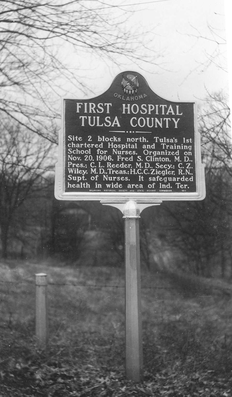
First Hospital, Tulsa County
Tulsa CountyLocation: on West Eleventh Street, between Jackson and Lawton streets, in Tulsa
Topics: Social/Cultural, Recreational/Service, Territorial Period 1861–1907
The site is two blocks north. Tulsa's first chartered Hospital and Training School for Nurses was organized on November 20, 1906. It was headed by Fred S. Clinton, M.D., president; C. L. Reeder, M.D., secretary; C. Z. Wiley, M.D., treasurer; and H. C. C. Ziegler, R.N., superintendent of nurses. It safeguarded health in a wide area of Indian Territory.
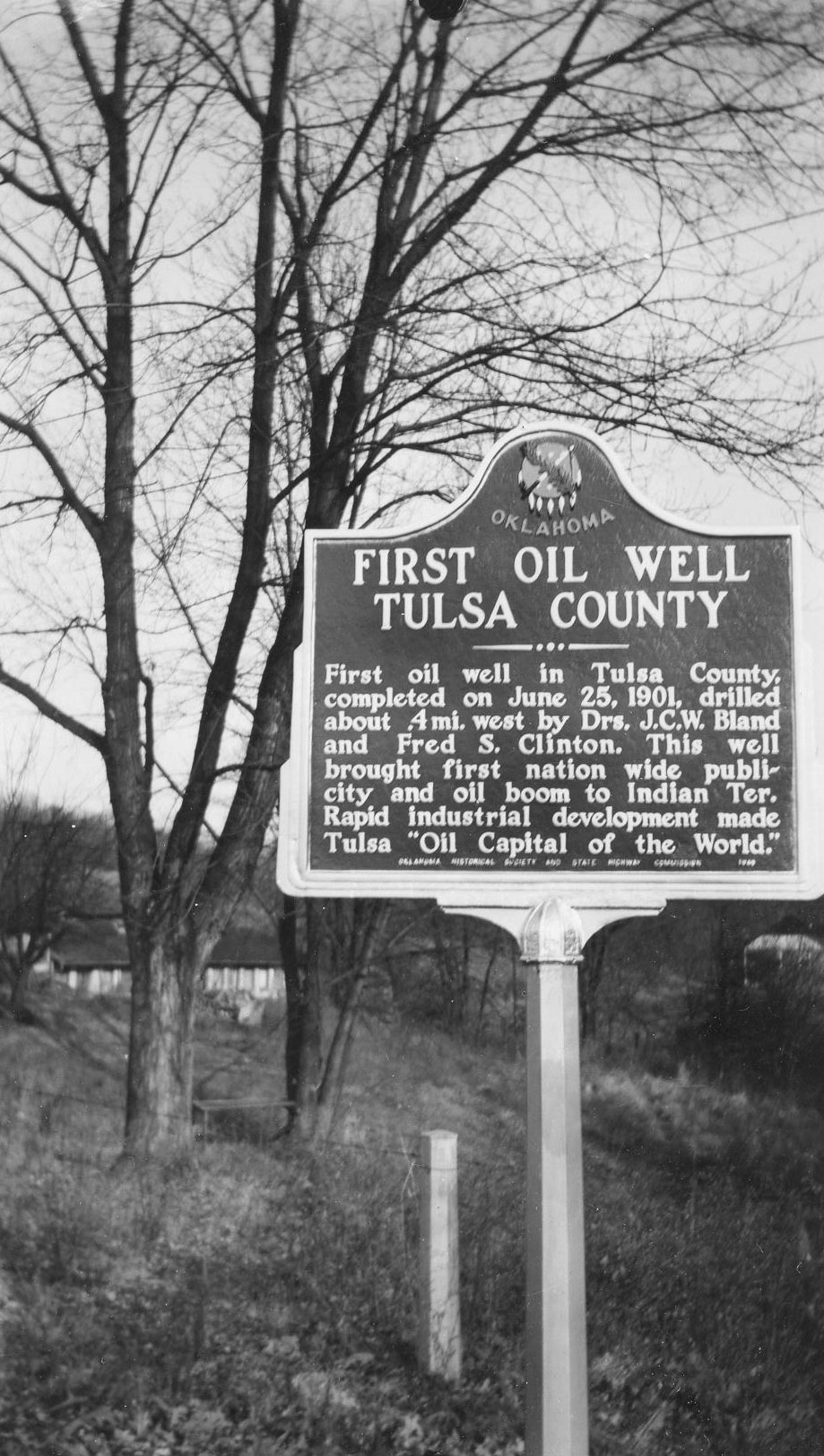
First Oil Well, Tulsa County
Tulsa CountyLocation: on 66 at the north side of Red Fork
Topics: American Indians, Settlement Patterns, Petroleum, Natural Resources, Industrial Period 1841–1892
This well about a half-mile west of the marker was on the Creek allotment of Dr. Bland's wife and was in production with oil royalties, paying the Bland heirs until the well was closed down around 1952.
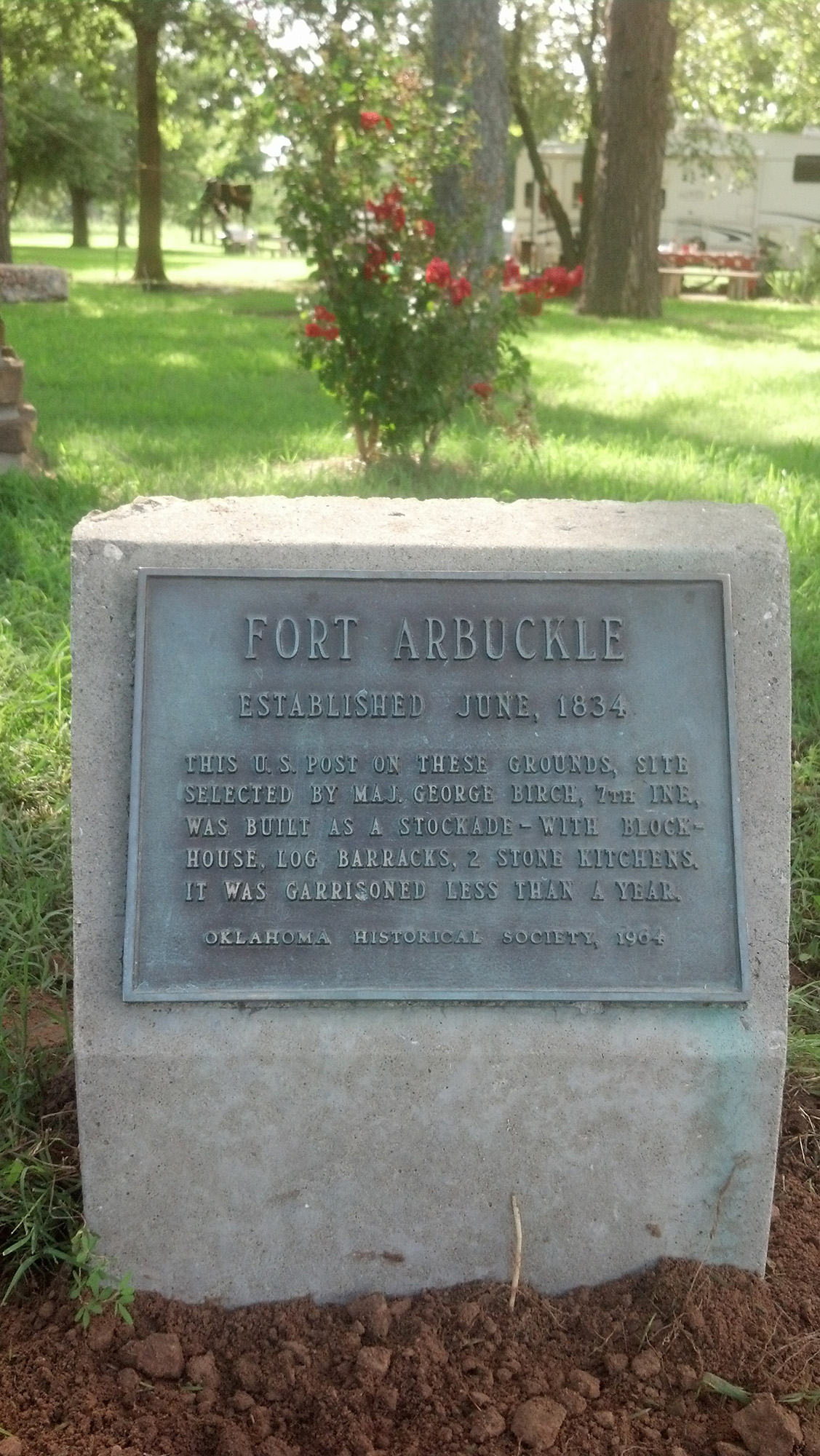
Fort Arbuckle
Tulsa CountyLocation: in Brush Creek Park near Sand Springs
Sponsored by: Tulsa County Historical Society
Topics: Military, American Indians, Westward Expansion 1803–1861
The site of Fort Arbuckle is less than one mile north. One of the two US military posts on the western frontier of the Creek Nation, this "first" Fort Arbuckle in Indian Territory was built in 1834 by troops of the 7th Infantry with Major George Birch in command. The stockade buildings were garrisoned only a few months.
Glenn Pool World's Great Oil Pool
Tulsa CountyLocation: at the town of Glenpool, Tulsa County on the east side of US-75 at junction with SH-67.
Topics: Territorial Period 1861–1907, Petroleum, Industry/Business, Natural Resources
Glenn Pool opened on November 22, 1905. About one-half mile northwest of this point, Robert Galbreath and Frank Chesley brought in the Ida E. Glenn No. 1 Oil Well. This began the great growth of the oil industry in the city of Tulsa and the state of Oklahoma.
Hillside Mission
Tulsa CountyLocation: on OK-11, four miles north of Skiatook
Material: Aluminum
Topics: Religion/Philosophy, Social/Cultural, American Indians, Environmental/Cultural Ecology, Territorial Period 1861–1907
Reverend John Murdock established the Hillside Mission school in 1882 under the auspices of the Society of Friends. A nearby cemetery contains the grave of William C. Rogers, the last elected principal chief of the Cherokees prior to statehood.
Holmes Peak
Tulsa CountyLocation: on Keystone Expressway (US-64) at the intersection of 45th West Avenue in Tulsa
Topics: Religion/Philosophy, Social/Cultural, American Indians, Environmental/Cultural Ecology, Territorial Period 1861–1907
Holmes Peak is the only geographical feature on Earth officially named by a government in honor of Sherlock Holmes. The US Board on Geographic Names approved the name on October 24, 1984. Another officially named geographic feature to honor Holmes is a crater on the Moon named by Astronaut Harrison Schmidt on the Apollo 17 Moon Landing.
Indian Memorial
Tulsa CountyLocation: at entrance of Owen Park on West Edison Street in Tulsa (DAR)
Sponsored by: Daughters of the American Revolution
Topics: Government, American Indians
This is the spot where the Creek, Cherokee, and Osage national boundaries joined.
International Petroleum Exposition
Tulsa CountyLocation: on Tulsa State Fair Grounds
Material: Granite
Topics: Arts, Petroleum, Urban Development, Folklife, Natural Resources, Early Statehood 1907–1941
The huge Golden Driller honors the founding of the international showcase of the oil industry. During Tulsa's heyday as "Oil capital of the world," the annual exposition drew oil field exhibitors from around the world.
Katy Railroad Depot
Tulsa CountyLocation: On south Main Street in Broken Arrow
Coordinates: 36.048503, -95.790847
Material: Granite
Topics: Transportation
Construction began on the 24 x 50 foot depot on May 13, 1903. It was of wood set on timber pilings with a red tin roof. It jutted onto Main Street to allow a good view of the town. Grain elevators and cotton gins sprang up south of the tracks with a stockyard to the east. In 1988 the old depot was moved to Discoveryland. (BA. 100 yr. history, pg 63_ Broken Arrow Centennial 2002.
Mt. Zion Baptist Church
Tulsa CountyLocation: 419 North Elgin Avenue, Tulsa
Topics: Religion/Philosophy
Mt. Zion Baptist Church was organized in 1909 in a one-room frame school building located in the 300 block of North Hartford under the Revered Sandy Lyons. Church Founders included Mr. Aaron Ellis, Mrs. Kate Bell Baldridge, Reverend Alexander Brown, Mrs. Georgia Brown, Mrs. Cornelia Dallas, Mrs. Mary A. Grayson, Mrs. Hannah Hale, Mr. Jim Hale, Mrs. Ella Bell Johnson, Mrs. Caroline Lollis, Mrs. Ella Suggs, Mrs. Ida Rector, Mrs. Jeanette E. Webb and Mrs. Nellie Brown Wharton. Soon after Reverend R.A. Whitaker assumed the pulpit at Mt. Zion, the congregation was forced to move from the school building with only three days notice. Hardships, discouragement and disappointment would not deter the congregation and a permanent church home was erected at 419 North Elgin.The first service was held in the new $92,000 church on April 4, 1921. Nearly one month later, the imposing structure of Mount Zion was reduced to ashes during the Tulsa Race Riot on June 1, 1921. It took twenty-one years, until November 23, 1942, for the original mortgage of $50,000 to be retired. Reverend J. H. Dotson immediately started a Building Fund for a new church. W. S. and J. C. Latimer were architects and members of Mount Zion. Graduating from Booker T. Washington's famed Tuskegee Institute, the two brothers completed the drawings and plans for the new church. Bit by bit, Mt. Zion's members paid for rebuilding the basement of the old church and a new church. On Sunday, October 21, 1952, dedication services were held in "The Church That Faith Built." Nearly one year later, Rev. Dotson's health began to fail and the Reverend G. Calvin McCutchen accepted the leadership of Mt. Zion. Dr. McCutchen, serving longer than any other pastor, led the church in paying off the mortgage of the church. Under his leadership numerous improvements have been made including a nursery, the J. H. Dotson Memorial Scholarship Fund was established for Mt. Zion college students, and the addition of a multi-purpose facility known as the Family Life Center. The Center was renamed to the G. Calvin McCutchen Sr. Family Life Center in honor of Dr. McCutchen in 1998.
Oil Capital of the World
Tulsa CountyLocation: in Municipal Plaza in downtown Tulsa
Material: Granite
Tulsa has long been known as the Oil Capital of the World and the City That Oil Built. The rise of Tulsa to a place of preeminence in the petroleum industry began on June 25, 1901, when a well was brought in at Red Fork across the Arkansas River to the southwest. Tulsa leaders caused a bridge to be built between the two points and national publicity focused attention on Tulsa as a center of a new oil region. "When a major oil strike took place at the nearby Glenn Pool on Nov. 22, 1905, the production of oil in the area became so great that the term "Oil Capital of the World" was universally applied to Tulsa. Other fields were discovered and developed in adjacent areas to a point where, for a time, it was the largest oil producing center on earth. Tulsa remained in the forefront of exploration and development, financing, equipment manufacturing and provided skills and executive direction for a growing worldwide industry--hence it continued to hold the title: Oil Capital of the World.
Pleasant Porter
Tulsa CountyLocation: on US-64, at village of Leonard, about nine miles east of Bixby, Tulsa County
Topics: American Indians, Military, Government, Territorial Period 1861–1907, Religion/Philosophy
The home and grave near here are of the noted Creek leader, Pleasant Porter (1840–1907). Lt. Creek Reg. Mtd. Vols., Confederate Army; Porter was superintendent of schools in the Creek Nation, 1871; Captain of the lighthorsemen in the "Green Peach War," 1883; a delegate to Washington; president of the Sequoyah Statehood Convention, 1905; and Principal Chief of the Creek Nation, 1899-1907. His home was near the location of Woalaka Mission founded in 1881.
Tulsa Commercial Airport Runway
Tulsa CountyLocation: 6060 American Plaza in Tulsa
Topics: Transportation
This street was the original runway for the Tulsa Commercial Airport (subsequently named Cherokee Airpark). During the 1930s aviation in Tulsa included multiple airfields which were converted to residential neighborhoods as Tulsa grew. Tulsa Commercial Airport operated until the mid-1950s. The road you are viewing was the main runway, and a second runway extended northwest from this location.
Washington Irving's Camp
Tulsa CountyLocation: at West Easton Avenue and North Vancouver Street in Tulsa
Topics: Arts, Westward Expansion 1803–1861, Transportation
Washington Irving traveled through Tulsa County in 1832 during his tour of the prairies.
(Page 1 of 1)
Search for Markers
Search by keyword or browse by county to learn about more than 600 historical markers created to recognize key locations, events, and people in Oklahoma history.
Please note that some markers listed in this database may have been moved, damaged, or are no longer standing.
Browse by County
Adair County
Alfalfa County
Atoka County
Beaver County
Beckham County
Blaine County
Bryan County
Caddo County
Canadian County
Carter County
Cherokee County
Choctaw County
Cimarron County
Cleveland County
Comanche County
Cotton County
Craig County
Creek County
Custer County
Delaware County
Dewey County
Ellis County
Garfield County
Garvin County
Grady County
Grant County
Greer County
Harmon County
Harper County
Haskell County
Hughes County
Jackson County
Jefferson County
Johnston County
Kay County
Kingfisher County
Kiowa County
Latimer CountyAlfalfa County
Atoka County
Beaver County
Beckham County
Blaine County
Bryan County
Caddo County
Canadian County
Carter County
Cherokee County
Choctaw County
Cimarron County
Cleveland County
Comanche County
Cotton County
Craig County
Creek County
Custer County
Delaware County
Dewey County
Ellis County
Garfield County
Garvin County
Grady County
Grant County
Greer County
Harmon County
Harper County
Haskell County
Hughes County
Jackson County
Jefferson County
Johnston County
Kay County
Kingfisher County
Kiowa County
Le Flore County
Lincoln County
Logan County
Love County
Marshall County
Mayes County
McClain County
McCurtain County
McIntosh County
Murray County
Muskogee County
Noble County
Okfuskee County
Oklahoma County
Okmulgee County
Osage County
Ottawa County
Pawnee County
Payne County
Pittsburg County
Pontotoc County
Pottawatomie County
Pushmataha County
Roger Mills County
Rogers County
Seminole County
Sequoyah County
Stephens County
Texas County
Tillman County
Tulsa County
Wagoner County
Washington County
Washita County
Woods County
Woodward County
Contact Us
If you have questions, please contact:
Matthew Pearce
Oklahoma Historical Society
800 Nazih Zuhdi Drive
Oklahoma City, OK 73105
405-522-8659
matthew.pearce@history.ok.gov